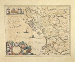
Items Similar to Old Print of Standia, a Greek Island 'Heraklion, Crete, Greece, Balkans', 1688


Want more images or videos?
Request additional images or videos from the seller
1 of 6
Old Print of Standia, a Greek Island 'Heraklion, Crete, Greece, Balkans', 1688
$273.44
$341.8020% Off
£205.96
£257.4420% Off
€232
€29020% Off
CA$377.09
CA$471.3620% Off
A$423.64
A$529.5520% Off
CHF 221.35
CHF 276.6920% Off
MX$5,170.72
MX$6,463.4020% Off
NOK 2,810.53
NOK 3,513.1620% Off
SEK 2,645.52
SEK 3,306.9020% Off
DKK 1,765.90
DKK 2,207.3720% Off
About the Item
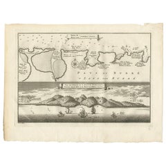
Antique print Greece titled 'Het Eilant Standia'. Old print of the island Standia, near Crete, Greece. This print originates from 'Nauwkeurige Beschrijving der eilanden in de in de Archipel der Middellantsche Zee' by O. Dapper.
Artists and Engravers: Olfert Dapper (c. 1635 - 1689) was a Dutch physician and writer. He wrote books about history and geography, although he never travelled outside Holland.
Condition: Very good, Dutch text on verso. Please study image carefully.
Date: 1688
Overall size: 19.5 x 30.5 cm.
Image size: 15 x 12.5 cm.
Antique prints have long been appreciated for both their aesthetic and investment value. They were the product of engraved, etched or lithographed plates. These plates were handmade out of wood or metal, which required an incredible level of skill, patience and craftsmanship. Whether you have a house with Victorian furniture or more contemporary decor an old engraving can enhance your living space. We offer a wide range of authentic antique prints for any budget.
- Dimensions:Height: 12.21 in (31 cm)Width: 7.88 in (20 cm)Depth: 0 in (0.01 mm)
- Materials and Techniques:
- Period:
- Date of Manufacture:1688
- Condition:Condition: Very good, Dutch text on verso. Please study image carefully.
- Seller Location:Langweer, NL
- Reference Number:Seller: BGI-002611stDibs: LU3054329901242
About the Seller
5.0
Recognized Seller
These prestigious sellers are industry leaders and represent the highest echelon for item quality and design.
Platinum Seller
Premium sellers with a 4.7+ rating and 24-hour response times
Established in 2009
1stDibs seller since 2017
2,534 sales on 1stDibs
Typical response time: <1 hour
- ShippingRetrieving quote...Shipping from: Langweer, Netherlands
- Return Policy
Authenticity Guarantee
In the unlikely event there’s an issue with an item’s authenticity, contact us within 1 year for a full refund. DetailsMoney-Back Guarantee
If your item is not as described, is damaged in transit, or does not arrive, contact us within 7 days for a full refund. Details24-Hour Cancellation
You have a 24-hour grace period in which to reconsider your purchase, with no questions asked.Vetted Professional Sellers
Our world-class sellers must adhere to strict standards for service and quality, maintaining the integrity of our listings.Price-Match Guarantee
If you find that a seller listed the same item for a lower price elsewhere, we’ll match it.Trusted Global Delivery
Our best-in-class carrier network provides specialized shipping options worldwide, including custom delivery.More From This Seller
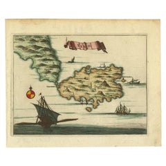
View AllAntique Print of a Greece Island, Most Likely Gavdopoula South of Crete, 1688
Located in Langweer, NL
Description: Untitled print of one of the islands of Greece, most likely Gavdopoula (located south of Crete).
Gavdopoula is an islet located north-west of its larger neighbour, G...
Category
Antique 1680s Maps
Materials
Paper
$330 Sale Price
20% Off
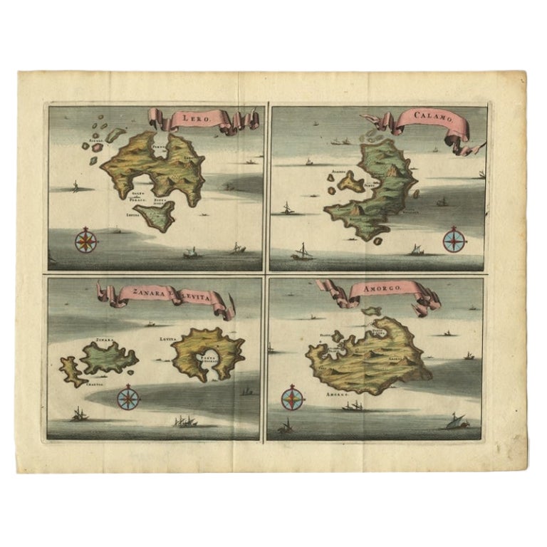
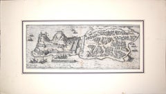
Original Antique Map of Leros and Kalimnos, and other islands, Greece, 1687
Located in Langweer, NL
Antique map titled 'Lero, Calamo, Zanara e Levita, Amorgo.'
heet with four maps on one page showing the islands Leros, Kalimnos, and other islands, Greece. Source unknown, to be de...
Category
Antique 17th Century Maps
Materials
Paper

$518 Sale Price
20% Off
Antique Map of the Island of Kyra Panagia by Dapper, 1688
Located in Langweer, NL
Antique map titled 'Pelagnisi.' Map of the island of Kyra Panagia, Pelagnisi (Pelagos), Greece. This map originates from 'Nauwkeurige Beschrijving der eilanden in de Archipel der Mid...
Category
Antique 17th Century Maps
Materials
Paper
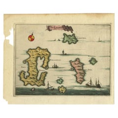
$141 Sale Price
20% Off
Antique Print of the Bay of Sierra Leone by J. Van Der Schley, 1758
Located in Langweer, NL
Beautiful map and bird's-eye view of the Bay of Sierra Leone. While these maps by Van Schley after Bellin were initially made for 'Histoire Generale des Voyages' (Paris, 1746-1759), ...
Category
Antique Mid-18th Century Prints
Materials
Paper
$150 Sale Price
20% Off
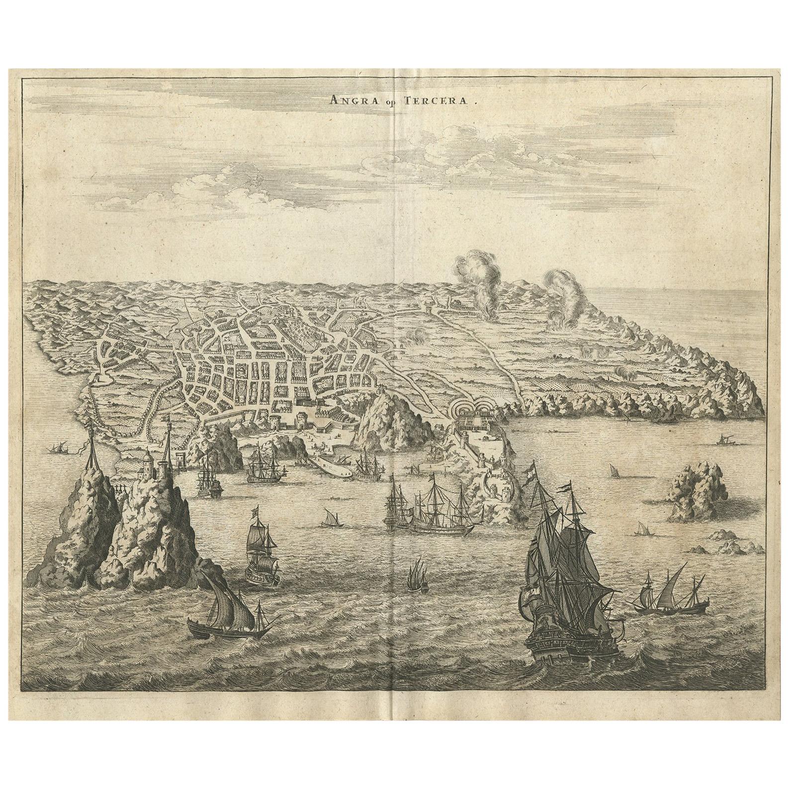
Antique Print of Angra 'Azores' by A. Montanus, 1671
By Arnoldus Montanus
Located in Langweer, NL
Antique print titled 'Angra op Tercera'. Antique print of Angra, Azores, in Portugal, during the mid-17th century. Shows roadways buildings, fortifications and geographical features;...
Category
Antique Mid-17th Century Prints
Materials
Paper

$486 Sale Price
24% Off
Antique Map of the Island of Tinos by Dapper, 1687
Located in Langweer, NL
Antique map titled 'Tino.' This original antique map shows the island of Tinos, Greece. Source unknown, to be determined.
Artists and Engravers: Made by 'Olfert Dapper' after an a...
Category
Antique 17th Century Maps
Materials
Paper
$165 Sale Price
20% Off
You May Also Like
Map of Greece - Original Etching by Antonio Zatta - 18th Century
Located in Roma, IT
This Map of Greece is an etching realized by Antonio Zatta, Cartographer, publisher and typographer.
The state of preservation of the artwork is good except for the worn paper and t...
Category
1780s Figurative Prints
Materials
Etching

Corfu, Big Antique Map from "Civitates Orbis Terrarum" - 1572-1617
By Franz Hogenberg
Located in Roma, IT
Braun G. and Hogenberg F., Corfu, from the collection Civitates Orbis Terrarum, Cologne, T. Graminaeus, 1572-1617. Image dimensions: cm 19 x 48; dimensions: cm 40 x 70.
Very lovely ...
Category
16th Century Landscape Prints
Materials
Etching
Antique Map - Mar Di Athiopia - Etching by Johannes Janssonius - 1650s
By Johannes Janssonius
Located in Roma, IT
Antique Map - Mar Di Athiopia is an antique map realized in 1650 by Johannes Janssonius (1588-1664).
The Map is Hand-colored etching, with coeval watercolorang.
Good conditions wit...
Category
1650s Modern Figurative Prints
Materials
Etching

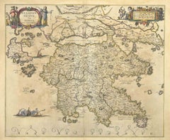
Peloponnesvs (Greece) - Etching by Johannes Janssonius - 1650s
By Johannes Janssonius
Located in Roma, IT
Peloponnesvs is an antique map realized in 1650 by Johannes Janssonius (1588-1664).
The Map is Hand-colored etching, with coeval watercoloring.
Good conditions with slight foxing.
...
Category
1650s Modern Figurative Prints
Materials
Etching
Epirus Albania - Etching by Johannes Janssonius - 1650s
By Johannes Janssonius
Located in Roma, IT
Epirus Albania is an ancient map realized in 1650 by Johannes Janssonius (1588-1664).
Good conditions.
From Atlantis majoris quinta pars, Orbem maritimum [Novus Atlas, volume V: ca...
Category
1650s Modern Figurative Prints
Materials
Etching
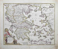
Accurata totius Archipelagi et Graeciae...- Etching by Frederick de Wit - 1680ca
By Frederick de Wit
Located in Roma, IT
This double-page etching with contemporary coloring, entitled Accurata totius Archipelagi et Graeciae Universae Tabula, was realized by the cartographer Frederick de Wit for the famo...
Category
1680s Modern Figurative Prints
Materials
Etching
More Ways To Browse
Boat Shaped Bowl
Brass Bed Finials
British Throne
Bureau Art Nouveau
Burmese Bench
Burmese Wood Figure
Cal Style
Carthage Antique
Carved Ironwood
Carvers And Gilders
Carvers Gilders
Channel Bed
Cherry Secretary
Chest With Writing Slide
Childrens Carriage
Chinese Amulet
Chinese Carnelian
Chinese Carved Hardwood Screen