Items Similar to Original Hand-Colored Antique Map of Tartary and Northern India

Want more images or videos?
Request additional images or videos from the seller
1 of 6
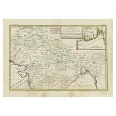
Original Hand-Colored Antique Map of Tartary and Northern India
$307.61
$384.5120% Off
£231.99
£289.9920% Off
€264
€33020% Off
CA$425.30
CA$531.6220% Off
A$476.41
A$595.5120% Off
CHF 250.23
CHF 312.7820% Off
MX$5,792.94
MX$7,241.1820% Off
NOK 3,168.67
NOK 3,960.8420% Off
SEK 3,007.92
SEK 3,759.9020% Off
DKK 2,009.74
DKK 2,512.1820% Off
About the Item
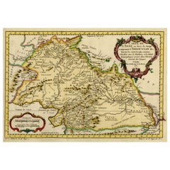
The antique map titled "Carte de la partie meridionale de la tartarie avec la p.tie septentrionale de l'nde" was crafted by Louis Brion de la Tour, a prominent French cartographer, and geographer in the 18th century. The map translates to "Map of the Southern Part of Tartary with the Northern Part of India."
Brion de la Tour was known for his meticulous cartographic skills and contributed significantly to the geographical knowledge of his time. This particular map, created during the 18th century, presents a depiction of the southern portion of Tartary, an ancient region in northern and central Asia, alongside the northern part of India.
As with many maps of that era, it likely features details on geographical boundaries, topographical features, major cities, rivers, and possibly cultural or historical notations relevant to the regions depicted. Brion de la Tour's maps were renowned for their accuracy and aesthetic appeal, often incorporating artistic elements along with precise cartographic information.
This specific map would have provided invaluable geographical knowledge and served as a significant reference tool for explorers, traders, and scholars of the time, shedding light on the territories of Tartary and northern India during the 18th century.
- Dimensions:Height: 9.45 in (24 cm)Width: 13.59 in (34.5 cm)Depth: 0 in (0.02 mm)
- Materials and Techniques:Paper,Engraved
- Period:1780-1789
- Date of Manufacture:ca.1780
- Condition:Good condition. Flattened folding lines from the publication it was taken from. Small margins on the right side, but leaving enough space for framing nicely.
- Seller Location:Langweer, NL
- Reference Number:Seller: BG-13513-11stDibs: LU3054337326102
About the Seller
5.0
Recognized Seller
These prestigious sellers are industry leaders and represent the highest echelon for item quality and design.
Platinum Seller
Premium sellers with a 4.7+ rating and 24-hour response times
Established in 2009
1stDibs seller since 2017
2,517 sales on 1stDibs
Typical response time: <1 hour
- ShippingRetrieving quote...Shipping from: Langweer, Netherlands
- Return Policy
Authenticity Guarantee
In the unlikely event there’s an issue with an item’s authenticity, contact us within 1 year for a full refund. DetailsMoney-Back Guarantee
If your item is not as described, is damaged in transit, or does not arrive, contact us within 7 days for a full refund. Details24-Hour Cancellation
You have a 24-hour grace period in which to reconsider your purchase, with no questions asked.Vetted Professional Sellers
Our world-class sellers must adhere to strict standards for service and quality, maintaining the integrity of our listings.Price-Match Guarantee
If you find that a seller listed the same item for a lower price elsewhere, we’ll match it.Trusted Global Delivery
Our best-in-class carrier network provides specialized shipping options worldwide, including custom delivery.More From This Seller
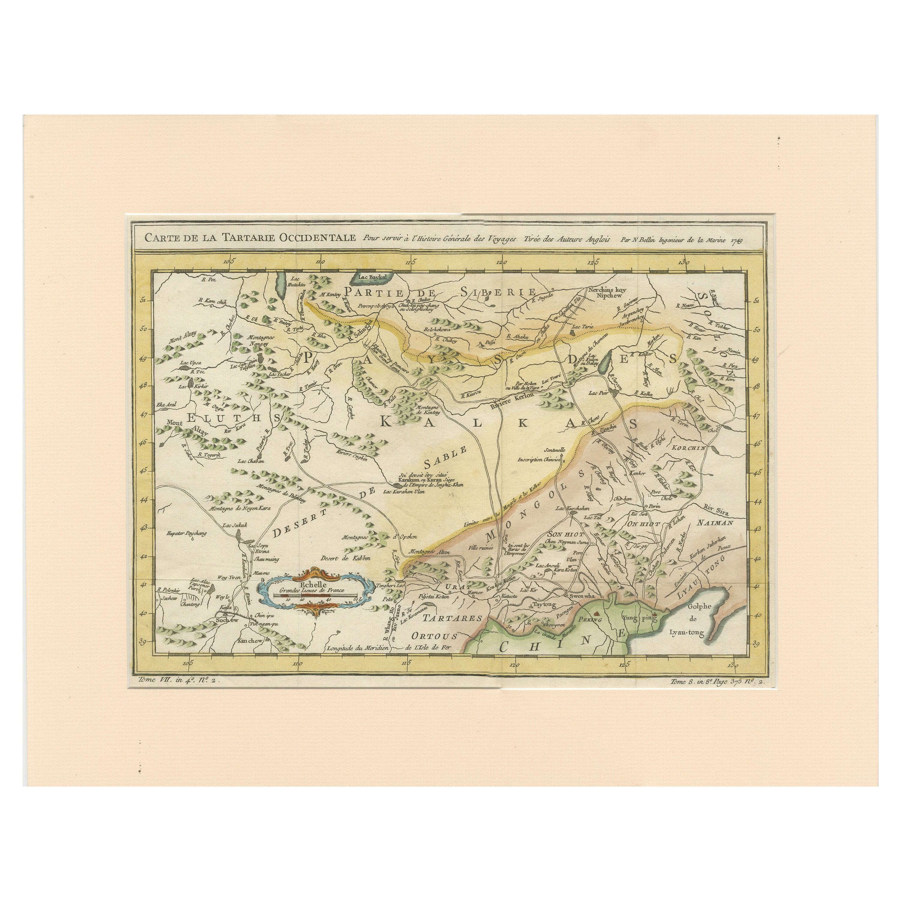
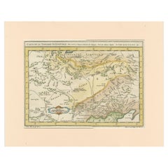
View AllAntique Map of Tartary and Northeast Asia with Hand Coloring
Located in Langweer, NL
Antique map titled 'Carte de la Tartarie Occidentale'. An interesting map of Tartary and northeast Asia, from Lake Baykal, Partie du Siberia in the north, Pays des Kalkas at the cent...
Category
Antique Mid-18th Century Maps
Materials
Paper
$261 Sale Price
20% Off
Nicely Hand-Colored Antique Map of Part of India, the Ganges & Hindustan, 1755
Located in Langweer, NL
Antique map titled 'Carte de l'Inde en deca du Gange comprenant l' Indoustan (..)'
A map of part of India, the Ganges and Hindustan. From: Antoine Francois Prevost d'Exiles' (or ...
Category
Antique 1750s Maps
Materials
Paper
$596 Sale Price
20% Off
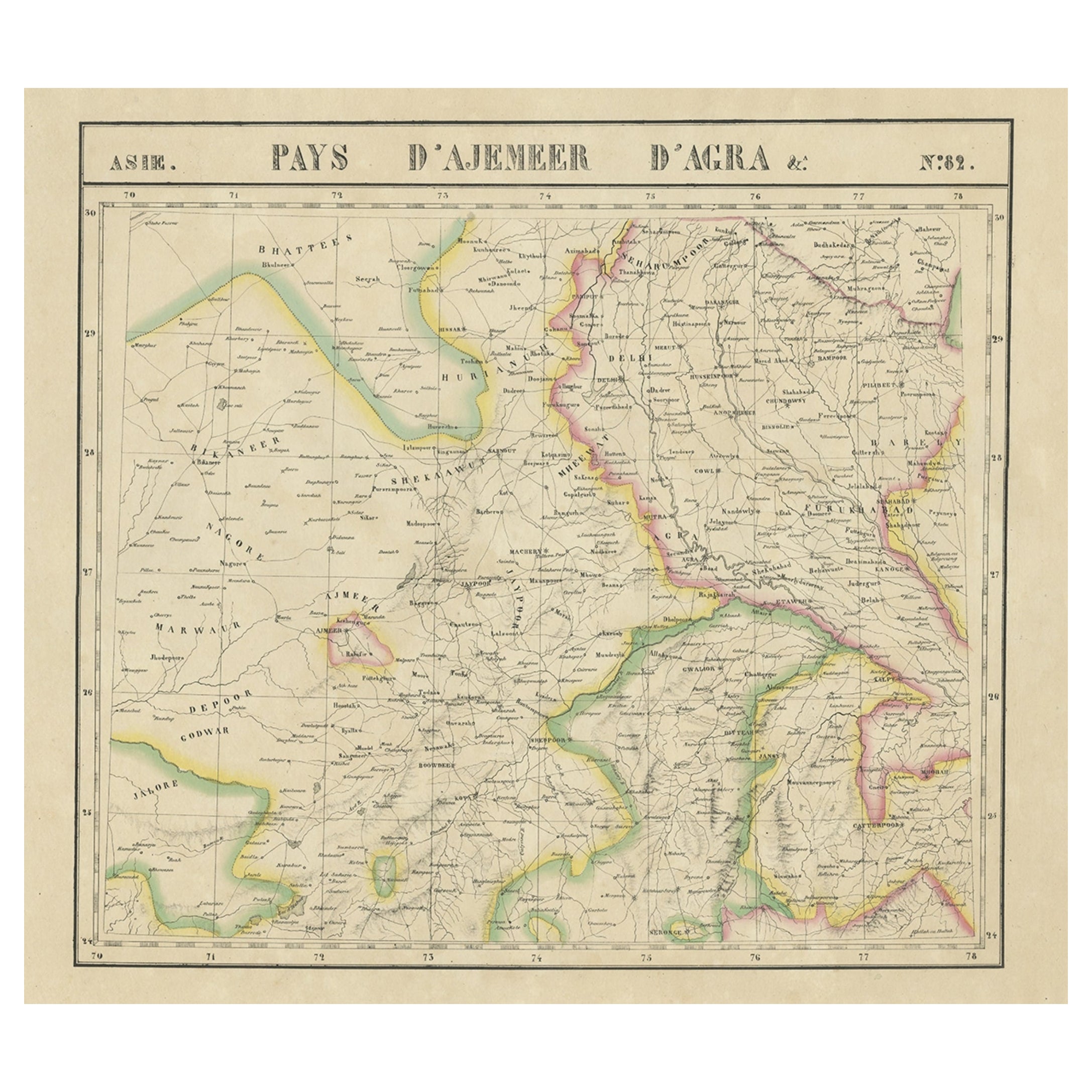
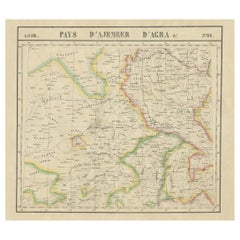
Large and Rare Antique Map of Northern India in Original Coloring, c.1825
Located in Langweer, NL
Antique map titled 'No. 82 Pays d'Ajemeer d'Agra'. Detailed map of Northern India. Originates from 'Atlas Universel' by P.M. Vandermaelen.
Artists and Engravers: Philippe Marie Van...
Category
Antique 19th Century Maps
Materials
Paper
$661 Sale Price
20% Off
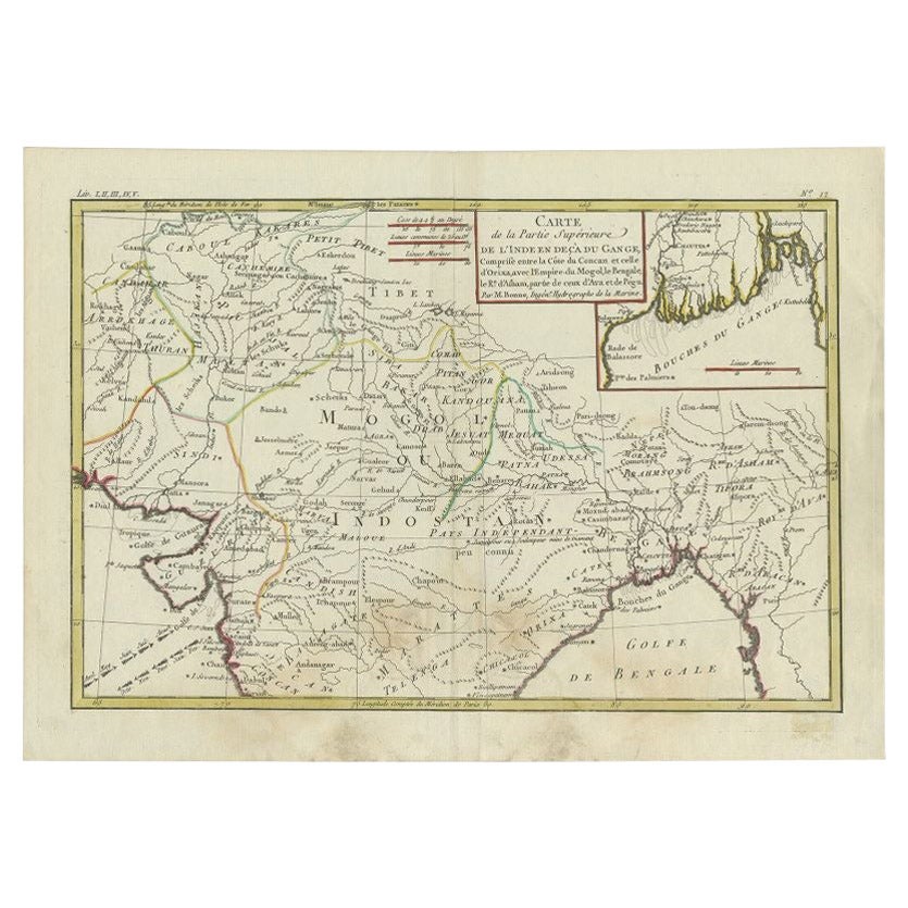
Antique Map of Northern India by Bonne, 1780
Located in Langweer, NL
Antique map titled 'Carte de la partie Supérieure de l'Inde (..)'. A fine example of Rigobert Bonne and Guilleme Raynal?s 1780 map of northern India. Covers the northern part of Indi...
Category
Antique 18th Century Maps
Materials
Paper
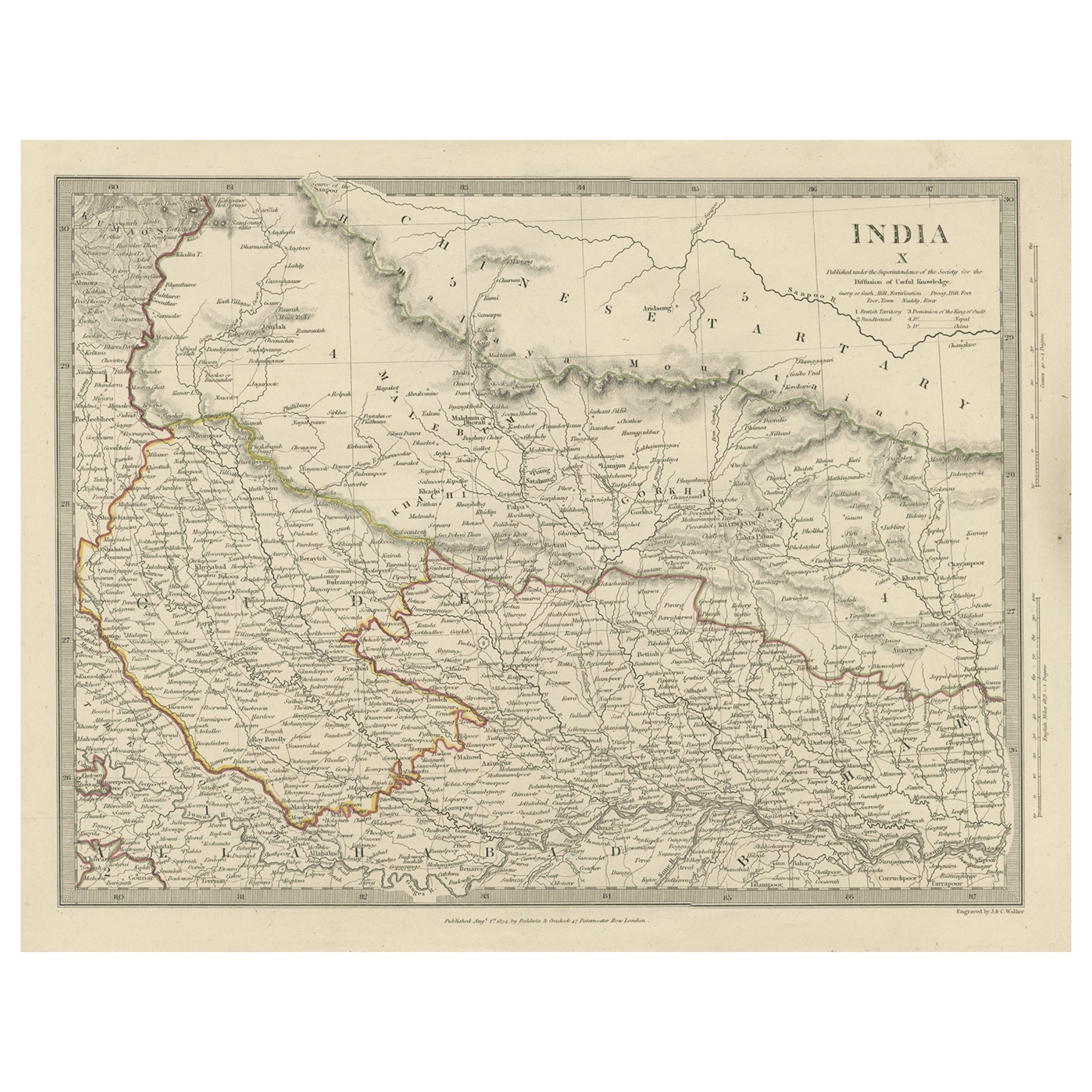
Original Antique Map of Part of the Bahar Region (India), 1834
Located in Langweer, NL
Antique map titled 'India X'. Old steel engraved map of part of the Bahar region, it also shows part of Nepal.
Artists and Engravers: Engraved by J. & C. Walker. Published under th...
Category
Antique 19th Century Maps
Materials
Paper
$270 Sale Price
20% Off
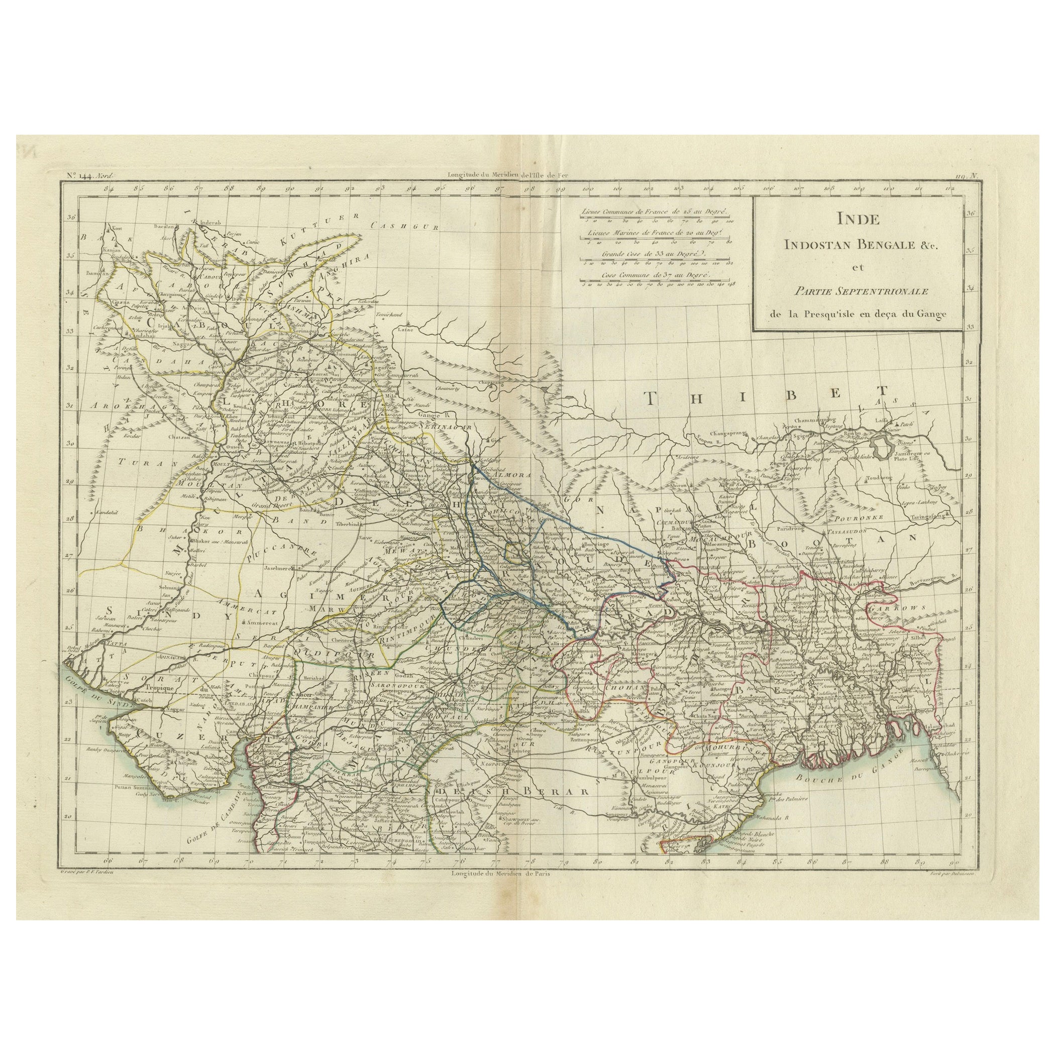
Antique Map of Northern India, Bengal, and Surrounding Regions by Tardieu, 1802
Located in Langweer, NL
This is an original antique map titled "Inde, Indostan Bengale &c. et Partie Septentrionale de la Presqu'isle en deça du Gange," depicting the northern part of the Indian subcontinen...
Category
Antique Early 1800s Maps
Materials
Paper
$410 Sale Price
20% Off
You May Also Like
Ancient National Atlas of France with Marengo
Located in Alessandria, Piemonte
Ancient National Atlas of France with the department of Marengo: a rare French etching dated 1806.
ST/178.
Category
Antique Early 19th Century French Other Prints
Materials
Paper

1851 Map of "Independent Tartary", Ric. R018
Located in Norton, MA
1851 Map of
Independent Tartary
"Russia"
Ric.r018
A highly decorative 1851 map of Independent Tartary by John Tallis and John Rapkin. Covers the regions between the Caspian Sea and Lake Bakquash and between Russia and Afghanistan. These include the ancient Silk Route kingdoms of Khiva, Tartaria, Kokand, and Bokhara. Today this region roughly includes Kazakhstan, Uzbekistan, Turkmenistan, Kyrgyzstan, and Tajikistan. This wonderful map offers a wealth of detail for anyone with an interest in the Central Asian portion of the ancient Silk Road. Identifies various caravan routes, deserts, wells, and stopping points, including the cities of Bokhara and Samarkand. Three vignettes by W. Bragg decorate the map, these including an image of Tartars on a Journey, a horseback Bride Chase, and a tartar camp site. Surrounded by a vine motif border. Engraved by J. Rapkin for John Tallis's 1851 Illustrated Atlas .
Tartary Antique Map...
Category
Antique 19th Century Unknown Maps
Materials
Paper

1849 Map of "Europaische Russland", 'Meyer Map of European Russia', Ric. R017
Located in Norton, MA
1849 Map of
"Europaische Russland"
( Meyer Map of European Russia)
Ric.r017
A lovely map of European Russia dating to 1849 by Joseph Meyer. It covers the European portions of...
Category
Antique 19th Century Unknown Maps
Materials
Paper

Antique 1803 Italian Map of Asia Including China Indoneseia India
Located in Amsterdam, Noord Holland
Antique 1803 Italian Map of Asia Including China Indoneseia India
Very nice map of Asia. 1803.
Additional information:
Type: Map
Country of Manufacturing: Europe
Period: 19th centu...
Category
Antique 19th Century European Maps
Materials
Paper

$584 Sale Price
20% Off
Original Antique Map of India by Dower, circa 1835
Located in St Annes, Lancashire
Nice map of India
Drawn and engraved by J.Dower
Published by Orr & Smith. C.1835
Unframed.
Free shipping
Category
Antique 1830s English Maps
Materials
Paper

17th Century Hand-Colored Map of a Region in West Germany by Janssonius
By Johannes Janssonius
Located in Alamo, CA
This attractive highly detailed 17th century original hand-colored map is entitled "Archiepiscopatus Maghdeburgensis et Anhaltinus Ducatus cum terris adjacentibus". It was published ...
Category
Antique Mid-17th Century Dutch Maps
Materials
Paper

More Ways To Browse
Calamander Wood
Cast Iron Horse Sculpture
Childrens Chest Of Drawers
Chinese Agate Snuff Bottle
Chinese Carved Ivory
Chinese Horse Terracotta
Chinese Root Wood Sculpture
Chinese Window Screen
Chippendale Burl Walnut
Concrete Bear Sculpture
Copper Moulds Antique
Cow Bell Used
Curtis Jere Bird Sculpture
Deer Figurines
Demilune Buffet
Doll House Toy
Dowry Box
Dragon Tea Set