Items Similar to World Map of Ocean Currents by A.K. Johnston, Educational Print 1852


Want more images or videos?
Request additional images or videos from the seller
1 of 10
World Map of Ocean Currents by A.K. Johnston, Educational Print 1852
$283.55per item
£212.54per item
€240per item
CA$389.55per item
A$434.89per item
CHF 227.88per item
MX$5,323.52per item
NOK 2,894.05per item
SEK 2,728.72per item
DKK 1,826.97per item
Quantity
Shipping
Retrieving quote...The 1stDibs Promise:
Authenticity Guarantee,
Money-Back Guarantee,
24-Hour Cancellation
About the Item
World Map of Ocean Currents by A.K. Johnston, Educational Print 1852
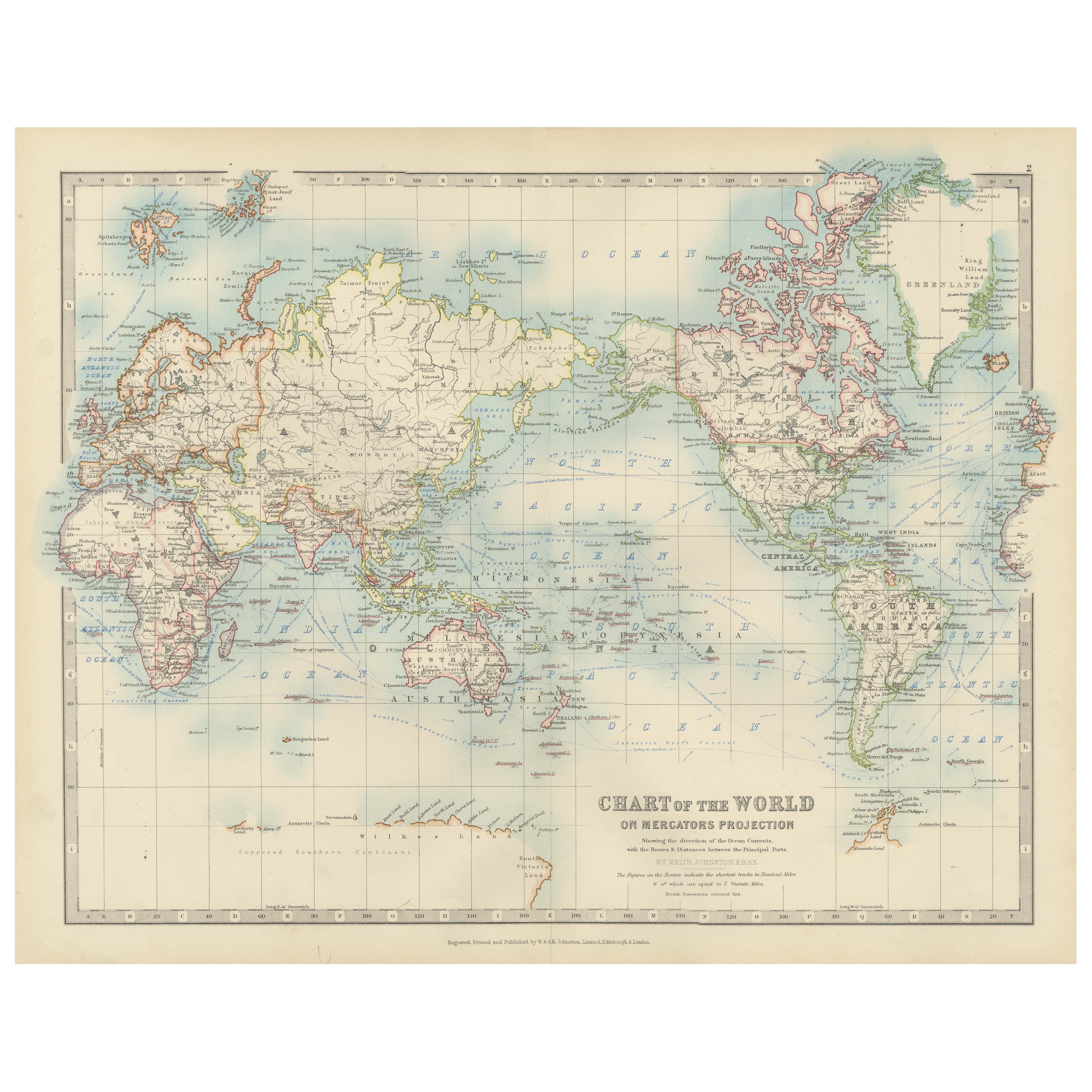
This detailed and scientifically rich chart titled 'Chart of the World Showing the Form & Direction of the Ocean Currents' was created by the Scottish cartographer Alexander Keith Johnston and published in 1852 by William Blackwood & Sons of Edinburgh and London. Issued as Plate 2 in a series on hydrology, it appeared in Johnston’s influential educational work *The Physical Atlas*.
The map illustrates the world’s ocean currents with remarkable clarity, using finely engraved directional arrows and shading to indicate both warm and cold currents across the globe’s seas. The Equatorial Current, Gulf Stream, Brazil Current, Kuroshio, and Antarctic Circumpolar Current are all clearly labeled and presented in relation to the major continents and climatic zones. The precise depiction of ocean flow patterns reveals the 19th-century understanding of global oceanography and its connection to trade, navigation, and climatology.
This map is not just a geographic representation, but a visual explanation of hydrological science. Two insets enhance the plate’s instructional value: one shows the “Proportion of Land & Water on the Globe,” and the other compares the relative elevation of mountain chains and ocean depths, including the Mariana Trench and Mount Everest. These contextual diagrams reflect the Enlightenment ideal of synthesizing visual data with scientific observation for public education.
Johnston (1804–1871) was known for merging scientific accuracy with elegant presentation. As “Geographer in Ordinary to Her Majesty for Scotland,” his maps were widely used in schools and universities. His Physical Atlas is considered one of the first thematic atlases, combining cartography with natural sciences.
This print is a compelling artifact of early scientific cartography, ideal for collectors of antique maps, maritime history, or 19th-century educational materials.
Condition and framing tips:
Excellent condition with minor age toning and clean margins. Frame in dark wood or matte black with a pale blue or neutral-toned mat to complement the soft blue engraving and highlight the fine scientific detailing.
- Dimensions:Height: 10.79 in (27.4 cm)Width: 13.59 in (34.5 cm)Depth: 0.01 in (0.2 mm)
- Materials and Techniques:
- Place of Origin:
- Period:
- Date of Manufacture:1852
- Condition:Very good antique condition. Clean impression with light age-toning and minimal foxing. Edges show only minor wear. Fold in middle as issued. Suitable for immediate display or archival framing.
- Seller Location:Langweer, NL
- Reference Number:Seller: BG-13207-21stDibs: LU3054345385652
About the Seller
5.0
Recognized Seller
These prestigious sellers are industry leaders and represent the highest echelon for item quality and design.
Platinum Seller
Premium sellers with a 4.7+ rating and 24-hour response times
Established in 2009
1stDibs seller since 2017
2,511 sales on 1stDibs
Typical response time: <1 hour
- ShippingRetrieving quote...Shipping from: Langweer, Netherlands
- Return Policy
Authenticity Guarantee
In the unlikely event there’s an issue with an item’s authenticity, contact us within 1 year for a full refund. DetailsMoney-Back Guarantee
If your item is not as described, is damaged in transit, or does not arrive, contact us within 7 days for a full refund. Details24-Hour Cancellation
You have a 24-hour grace period in which to reconsider your purchase, with no questions asked.Vetted Professional Sellers
Our world-class sellers must adhere to strict standards for service and quality, maintaining the integrity of our listings.Price-Match Guarantee
If you find that a seller listed the same item for a lower price elsewhere, we’ll match it.Trusted Global Delivery
Our best-in-class carrier network provides specialized shipping options worldwide, including custom delivery.More From This Seller
View AllAntique World Map on Mercator's Projection, Ocean Currents and Trade Routes 1903
Located in Langweer, NL
Title: Antique World Map on Mercator's Projection, 1903, Showing Ocean Currents and Trade Routes
Description:
This antique map, titled "Chart of the World on Mercator's Projection,"...
Category
Early 20th Century Maps
Materials
Paper

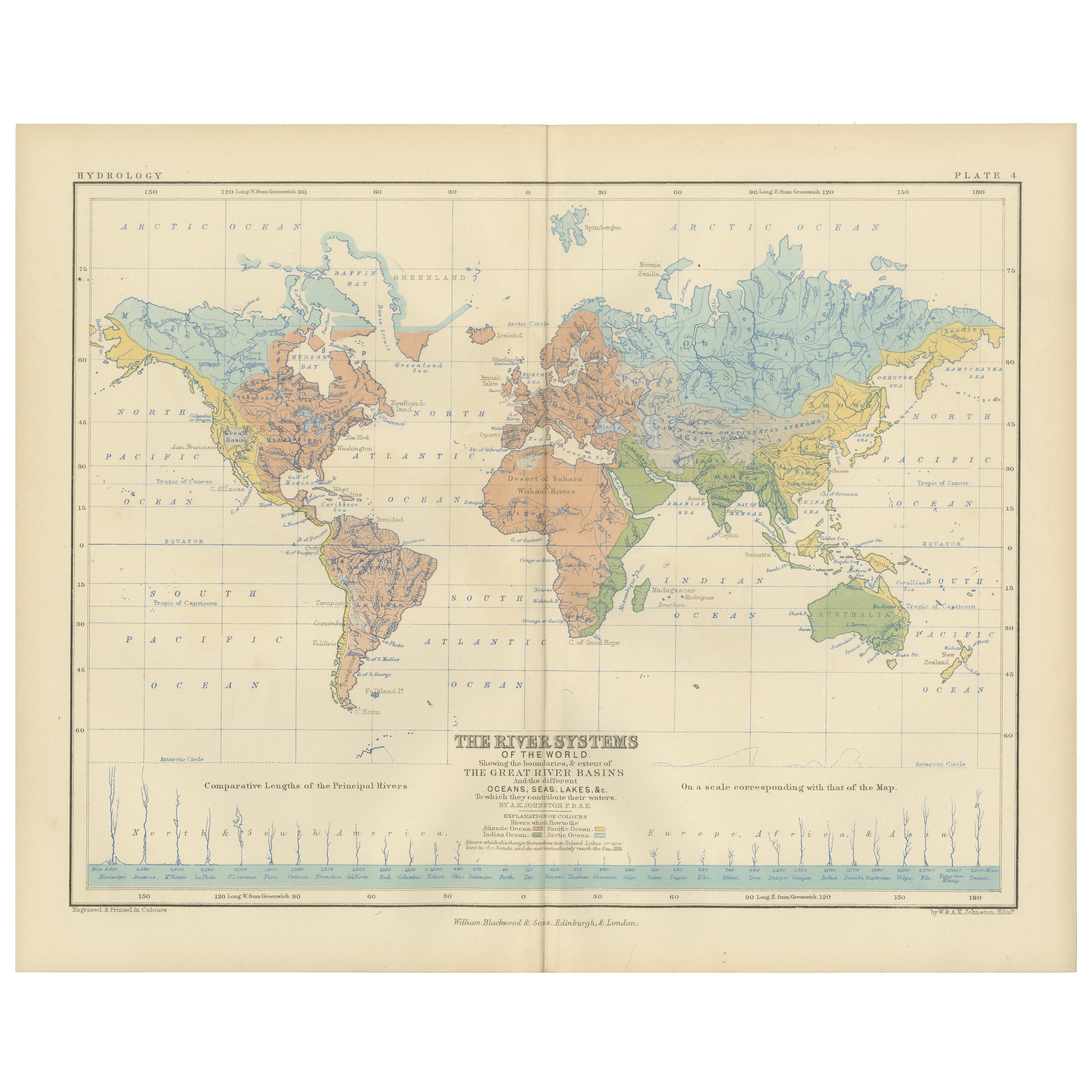
River Systems Map of the World by A.K. Johnston – Educational Print 1852
Located in Langweer, NL
River Systems Map of the World by A.K. Johnston – Educational Print 1852
This striking 1852 map titled "The River Systems of the World" was created by the noted Scottish geographer ...
Category
Antique Mid-19th Century Scottish Prints
Materials
Paper

Antique Map Showing the Ocean Currents and Temperature of Air, '1872'
Located in Langweer, NL
Two maps on one sheet titled 'Johnson's Oceans Currents (..)' and 'Johnson's World showing the Distribution of the Temperature of the Air'. Original world map...
Category
Antique Late 19th Century Maps
Materials
Paper

$330 Sale Price
20% Off
Wind and Hurricane Map by A.K. Johnston – Meteorological Chart 1852
Located in Langweer, NL
Wind and Hurricane Map by A.K. Johnston – Meteorological Chart 1852
This scientifically significant 1852 map titled "The Distribution of the Constant, Periodical & Variable Winds Ov...
Category
Antique Mid-19th Century Scottish Prints
Materials
Paper

Antique Map Showing the Distribution of the Currents of Air by Johnston '1850'
Located in Langweer, NL
Antique map titled 'Geographical Distribution of the Currents of Air'. Original antique map showing the distribution of the currents of air. This map originates from 'The Physical At...
Category
Antique Mid-19th Century Maps
Materials
Paper

$189 Sale Price
20% Off
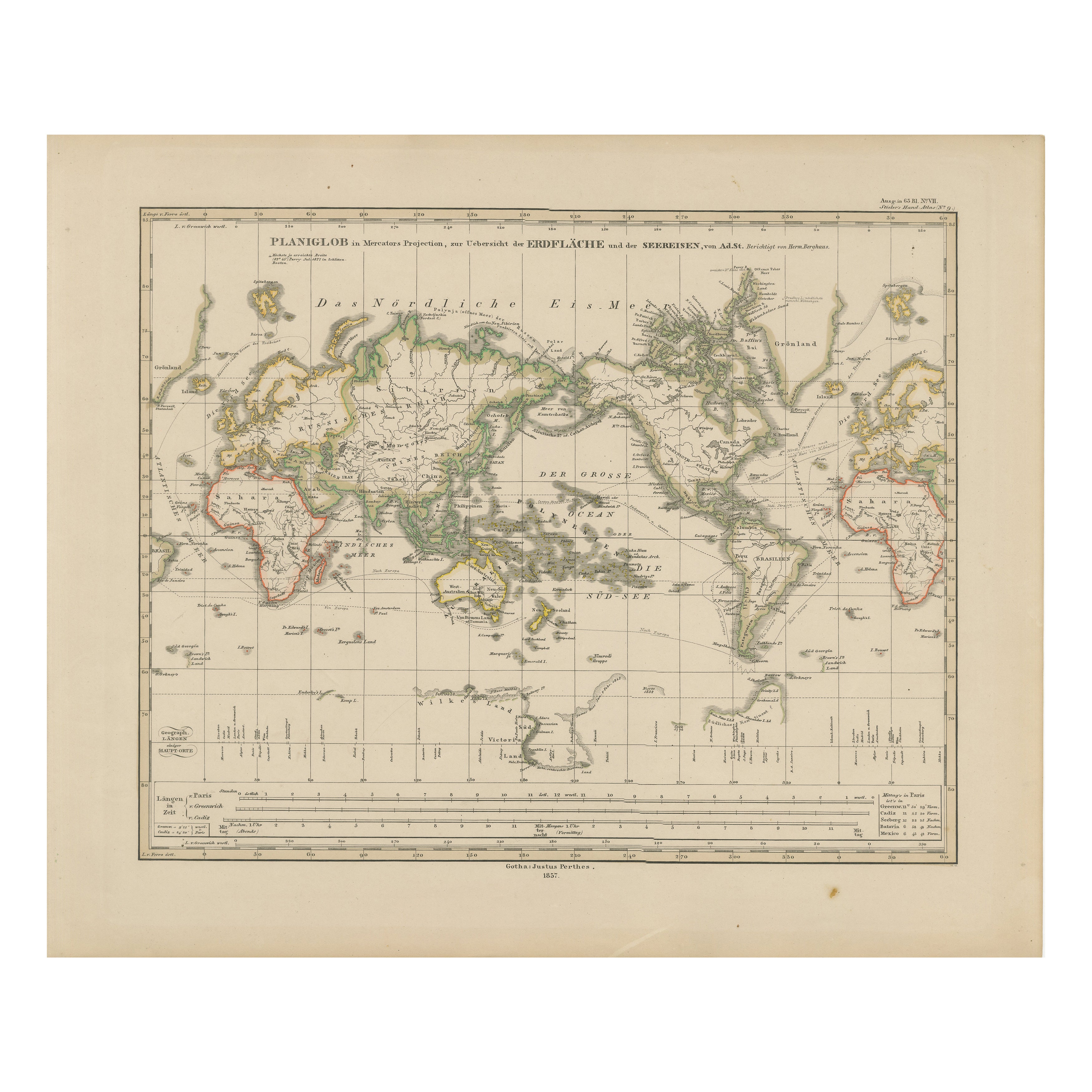
World Map – Mercator Projection with Global Sea Routes, Published in 1857
Located in Langweer, NL
World Map – Mercator Projection with Global Sea Routes 1857
This attractive antique print shows a world map titled “Planiglob in Mercators Projection zur Übersicht der Erdfläche und...
Category
Antique Mid-19th Century German Maps
Materials
Paper

You May Also Like
Large Original Antique Map of The Pacific Ocean, Fullarton, C.1870
Located in St Annes, Lancashire
Great map of The Pacific Ocean
From the celebrated Royal Illustrated Atlas
Lithograph by Swanston. Original color.
Published by Fullarton,...
Category
Antique 1870s Scottish Maps
Materials
Paper

Original Antique Map of The World by Dower, circa 1835
Located in St Annes, Lancashire
Nice map of the World
Drawn and engraved by J.Dower
Published by Orr & Smith. C.1835
Unframed.
Free shipping
Category
Antique 1830s English Maps
Materials
Paper

1864 Original illustrated planisphere - World Map - Geography
Located in PARIS, FR
Immerse yourself in the epic journey of the past with the Illustrated Historical Planisphere of 1864 by Charpentier! 🗺️ This cartographic treasure transports you through the intrica...
Category
1860s Prints and Multiples
Materials
Linen, Lithograph, Paper

Original Antique Map of The Western Hemisphere by Dower, circa 1835
Located in St Annes, Lancashire
Nice map of the Western Hemisphere
Drawn and engraved by J.Dower
Published by Orr & Smith. C.1835
Unframed.
Free shipping
Category
Antique 1830s English Maps
Materials
Paper

Ancient Map of Oceania - Original Etching - 19th century
Located in Roma, IT
This Map of Oceania is an etching realized in the 19th century.
The state of preservation of the artwork is good. At the top of the paper, the inscription “Longitudine del Meridiano...
Category
19th Century More Prints
Materials
Etching

Map of the World - Original Etching - 1820
Located in Roma, IT
Map of the World is an Original Etching realized by an unknown artist of 19th century in 1820.
Very good condition on two sheets of white paper joine...
Category
1820s Modern Figurative Prints
Materials
Etching

More Ways To Browse
French Herbarium
French Kitchen Hutch
French Regency Bed
French Tea Trolley
Frog Wood Sculpture
George Iii Dressing Table
Georgian Style China Cabinet
Ginger Jar Blossom
Glass Music Box
Golden Closet
Greek Key Tray
Grotto Wall
Gun Storage
Gustavian Tall Cabinet
Half Round Window
Hand Carved Elephant Head
Haute Savoie Furniture
Haviland China