Items Similar to Four Framed Hogarth Engravings "Four Times of the Day"

Want more images or videos?
Request additional images or videos from the seller
1 of 24
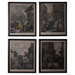
William HogarthFour Framed Hogarth Engravings "Four Times of the Day"1738, 1822
1738, 1822
$6,775
£5,145.78
€5,918.59
CA$9,466
A$10,555.66
CHF 5,507.50
MX$129,521.98
NOK 70,101.65
SEK 66,419.79
DKK 44,172.61
Shipping
Retrieving quote...The 1stDibs Promise:
Authenticity Guarantee,
Money-Back Guarantee,
24-Hour Cancellation
About the Item
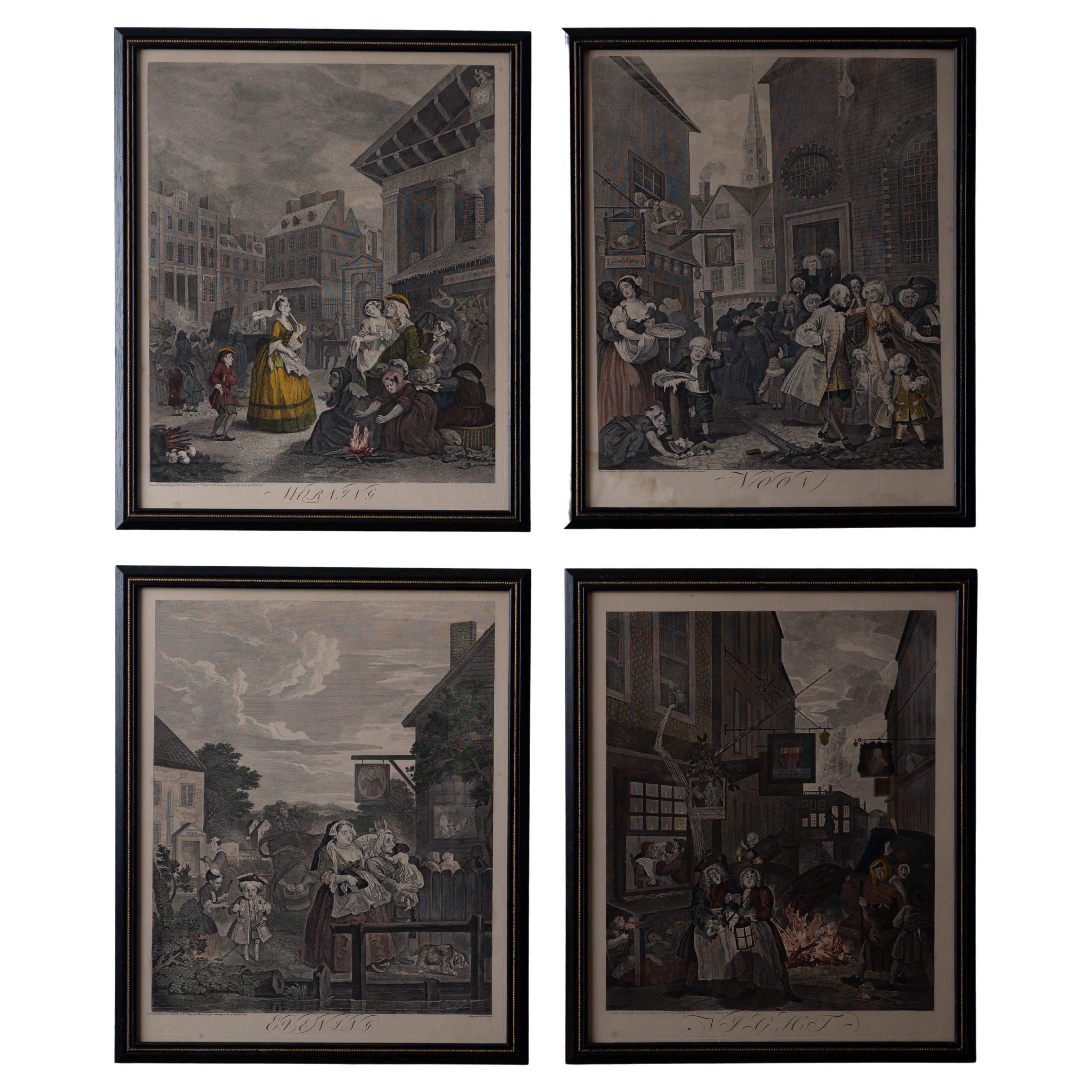
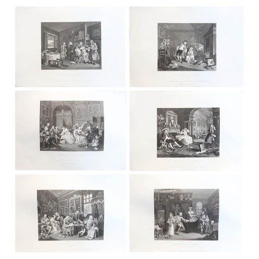
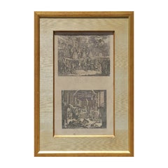
The four plates in this "Four Times of the Day" set were created utilizing both engraving and etching techniques by William Hogarth in 1738. Hogarth's original copper plates were refurbished where needed by James Heath and these engravings were republished in London in 1822 by Braddock, Cradock & Joy. This was the last time Hogarth's original copper plates were used for printing. Most were melted down during World War I for the construction of bombs. Printed upon early nineteenth century wove paper and with large, full margins as published by William Heath in 1822. The inscription below each print reads "Invented Painted & Engraved by Wm. Hogarth & Publish'd March 25. 1738 according to Act of Parliament".
These large folio sized "Four Times of the Day" engravings/etchings are presented in complex gold-colored wood frames with black bands and scalloped gold inner trim. A majority of each thick impressive frame is covered with glass applied near the outer edge. Each frame measures 25.75" high, 22.25" wide and 1.88" deep. There are a few small dents in the edge of these frames, which are otherwise in very good condition. "Morning" has two focal areas of discoloration in the upper margin and some discoloration in the right margin, a short tear in the left margin and a short tear or crease in the right margin. "Noon" has a spot in the upper margin that extends into the upper image, but it is otherwise in very good condition. "Evening" has a faint spot in the upper margin, but it is otherwise in very good condition. "Night" is in excellent condition.
The "Four Times of the Day" series is in the collection of many major museums, including: The British Museum, The Metropolitan Museum of Art, The Tate Museum, The Chicago Art Institute and The Victoria and Albert Museum.
Through this series Hogarth is portraying early 18th century London street life at "Four Times of the Day". His characters are exhibiting their personalities, quircks, strange activities, but he also wants to draw attention the disparities between the wealthy aristocracy and the common working class.
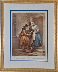
Plate 1, "Morning" depicts morning in Covent Garden in the winter in front of Tom King's Coffee House, where a fight has broken out in the doorway and someone's wig flies through the air. Vegetable and fruit vendors are setting up their display for the morning market, while two aristocratic men are fondling and kissing young market girls behind them. They are observed by a well-dressed elderly woman, who is heading to St. Paul's for church services. Her obviously very cold page boy follows her carrying her prayer book. The woman is ignoring a woman begging for a donation. In the upper right a clock above St. Paul's shows that is almost 7:00 AM. A small statue above the clock depicts Father Time with a scythe and an hourglass. Below the clock are the words "Sic Transit Gloria Mundi" (Thus passes the Glory of the World). In the lower left two children watch a woman carry a loaded basket of vegetables on her head on her way to sell them in the market.
Plate 2, "Noon" is thought to represent the dichotomy between the lives of the 18th century English working classes and that of the aristocracy. People exiting a French Huguenot church in the Soho region on the right are the wealthy and aristocracy, as well as the clergy. An aristocratic man, woman and child are showing off their elevated status with their dress and carriage. The man and even the child are carrying fashionable canes and a child seen from the rear is wearing extremely expensive clothing and a head covering resembling a beehive. The working class are seen on the left in the street in front of a restaurant with a sign "Good Eating" and a tavern called "Good Woman". A woman leaning out of a window on the second floor is arguing with a man over a plate of food and has spilled her food into the street below. A footman is fondling a servant girl from behind. She is carrying a tray, which may have contained a plate which has fallen off onto a young boy's head. He is rubbing his head and crying because his plate carrying a pie has broken and the pie has fallen to the street, where a young street urchin girl is eating it the remnants. No one pays attention to a dead cat which lies in the middle of the street. Life on both sides of the street seems to have its problems. The clock on the tower of St. Giles-in-the-Fields in the background reads 11:30 or 11:45, almost Noon.
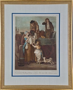
Plate 3, "Evening" depicts Islington is the northern edge of London, a popular amusement center for London's middle class. Unlike the crowded London city streets, here we see expansive sky and rolling hills in the background with an evening sunset, probably in summer. Sadlers Wells Theater on the left was belittled at the time for attracting tradesmen and domineering snobbish wives. In the foreground is a large, possibly pregnant woman who is walking next to her husband who looks unhappy, meek, presumably brow-beaten. A cow is being milked behind them. The horns of the animal are projected over the man's head, presumably symbolizing his lowly family stature. Even the dog walking in front, hanging his head and appearing downtrodden. On the left a girl scolds a boy who is crying, presumably mimicking their parent's relationship. A pub is seen on the right with people enjoying the evening and in an outdoor seating area.
Plate 4, "Night" depicts a side street in Charing Cross. Night deals with the miseries of London life. Two pubs are seen on this small street, the Earl of Cardigan on the left and the Rummer Tavern on the right. These were both Freemason Lodges in the 1730's when the print was composed by Hogarth. To the left, a drunken barber-dentist has just cut his customer. Bowls of blood from earlier patients lie on a ledge outside the window. Homeless people are huddled together for warmth under the ledge. In the foreground a drunken man and a woman stumble down the street. Blood on their heads suggests a recent bar fight. The contents of a chamber pot fall on them from a window above them. He is thought to represent Sir Thomas de Veil, a magistrate who was well known at the time for the severity of his sentencing, in particular for gin-sellers. Ironically, he is too drunk to notice the chaos around him. On the right the 'Salisbury Flying Coach' has overturned next to a bonfire. People are trying to get out, while someone inside has fired their gun. Everything on the street seems in chaos, with the exception of man, possibly a tavern or inn keeper, who is calmly smoking a pipe while he pours the contents of a barrel into a larger barrel. The equestrian statue of Charles I by Le Sueur is seen in the background at the end of the street.
Artist: William Hogarth (1697-1764) was an English painter, printmaker, pictorial satirist, social critic, and editorial cartoonist. Hogarth's work was extremely diverse, ranging from serious realistic paintings and portraits to satire and moralistic pieces filled with symbolism. He often communicated his moral message in a series of paintings and engravings, such as: A Rake's Progress, Marriage A-la-Mode and A Harlot's Progress. He was by far the most significant English artist of his generation and inspired a movement of English caricaturists and satirists, including James Gillray (1756-1815), Thomas Rowlandson (1757-1827), Isaac Cruickshank (1764-1811) and George Cruickshank (1792-1878). His work has been studied intensely for the greater than two and a half centuries since his death with several academic scholars focusing their careers on the analysis of every element of each of his creations.
- Creator:William Hogarth (1697 - 1764, British)
- Creation Year:1738, 1822
- Dimensions:Height: 25.75 in (65.41 cm)Width: 22.25 in (56.52 cm)Depth: 1.88 in (4.78 cm)
- Medium:
- Movement & Style:
- Period:
- Condition:
- Gallery Location:Alamo, CA
- Reference Number:Seller: #'s: 4403, 4404, 4405 and 44061stDibs: LU117326611682
William Hogarth
William Hogarth (1697-1764) was an English painter, printmaker, pictorial satirist, social critic, and editorial cartoonist. Hogarth's work was extremely diverse, ranging from serious realistic paintings and portraits to satire and moralistic pieces filled with symbolism. He often communicated his moral message in a series of paintings and engravings, such as: A Rake's Progress, Marriage A-la-Mode and A Harlot's Progress. He was by far the most significant English artist of his generation and inspired a movement of English caricaturists and satirists, including James Gillray (1756-1815), Thomas Rowlandson (1757-1827), Isaac Cruickshank (1764-1811) and George Cruickshank (1792-1878). His work has been studied intensely for the greater than two and a half centuries since his death with several academic scholars focusing their careers on the analysis of every element of each of his creations.
About the Seller
5.0
Platinum Seller
Premium sellers with a 4.7+ rating and 24-hour response times
Established in 2011
1stDibs seller since 2019
285 sales on 1stDibs
Typical response time: 1 hour
- ShippingRetrieving quote...Shipping from: Alamo, CA
- Return Policy
Authenticity Guarantee
In the unlikely event there’s an issue with an item’s authenticity, contact us within 1 year for a full refund. DetailsMoney-Back Guarantee
If your item is not as described, is damaged in transit, or does not arrive, contact us within 7 days for a full refund. Details24-Hour Cancellation
You have a 24-hour grace period in which to reconsider your purchase, with no questions asked.Vetted Professional Sellers
Our world-class sellers must adhere to strict standards for service and quality, maintaining the integrity of our listings.Price-Match Guarantee
If you find that a seller listed the same item for a lower price elsewhere, we’ll match it.Trusted Global Delivery
Our best-in-class carrier network provides specialized shipping options worldwide, including custom delivery.More From This Seller
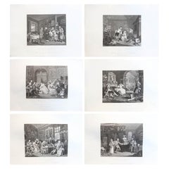
View AllWilliam Hogarth's "Analysis of Beauty": A Set of Two Framed 18th C. Engravings
By William Hogarth
Located in Alamo, CA
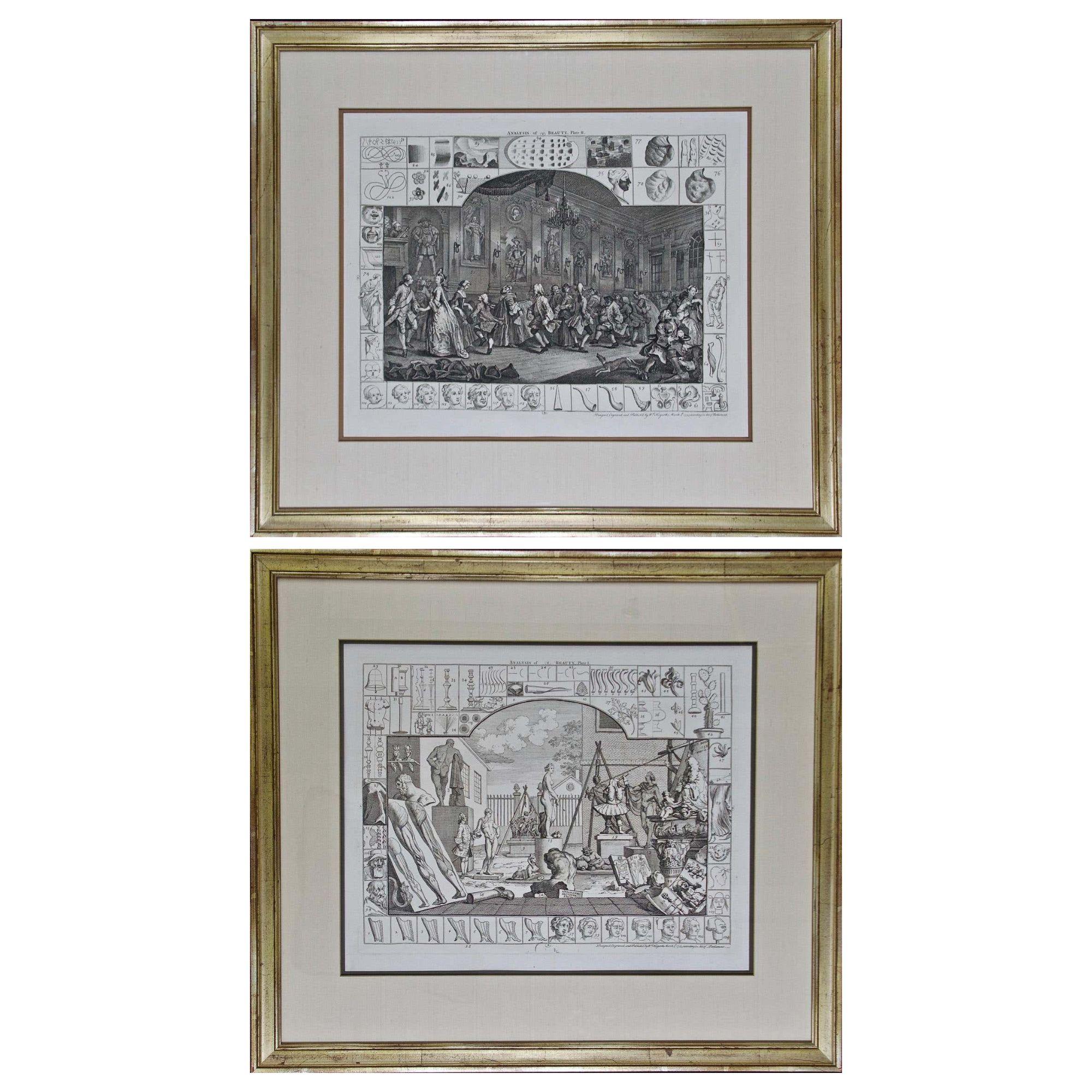
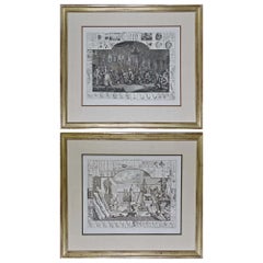
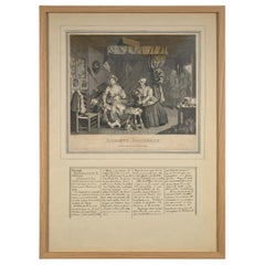
The two plates in this set were created utilizing both engraving and etching techniques by William Hogarth in 1753, originally as illustrations of his book on aesthetics, entitled "Analysis of Beauty". Due to their popularity, these plates were later published separately. The publication line in the lower right reads: "Designed, Engraved, and Publish'd by Wm. Hogarth, March 5th 1753, according to Act of Parliament." Hogarth's original copper plates were refurbished where needed by James Heath and engravings were republished in London in 1822 by Braddock, Cradock & Joy. This was the last time Hogarth's copper plates were used for printing. Most were melted during World War I for the construction of bombs.
These large folio sized "Analysis of Beauty" engravings are presented in antiqued gold-colored frames with double mats; the outer silk mats are light brown-colored and the inner mats are dark brown. Each frame measures 27.38" x 31.25" x 1.13". There is one tiny spot in the right margin of plate 1 and another in the lower margin; the latter could be from the printing process. The prints are otherwise in excellent condition.
The "Analysis of Beauty" series is in the collection of many major museums, including: The British Museum, The Metropolitan Museum of Art, The Tate Museum, The Chicago Art Institute and The Fine Arts Museums of San Francisco.
The first engraving (Plate 1) depicts a courtyard of statues which is filled with some of the most famous works of classical sculpture. The most important sculptures are surrounded by less impressive works. The Medicean Venus (#13) is in the center with a statue of Julius Caesar (#19) to the right, elevated on a pulley with a short, overdressed Brutus stands over the falling Caesar. The Apollo Belvedere (#12) is next. A judge stands to the right with his foot on a cherub (#16). Another crying cherub holds a gallows and wipes his tears with the judge's robe.
A sphinx (#21) and the drunken Silenus (#107) are below the Venus. Michaelangelo's torso (#54) and a statue of Antonius (#6) are seen in the foreground. The Farnese Hercules (#3) and a bust of another Hercules (#4) under two statuettes of Isis are also included in the scene.
The key to these objects is included in the form of a serpentine line winding around a cone (#26), Hogarth's "Line of Beauty". For Hogarth the winding line is an essential element of beauty in art. Hogarth's theory of beauty is communicated in this plate.
Plate 2 is thought to represent the Wanstead Assembly, with the Earl of Tynley and his household. It is an adaptation of a scene in the Happy Marriage series, which complements Hogarth's Marriage à la Mode...
Category
Mid-18th Century Old Masters Interior Prints
Materials
Engraving, Etching
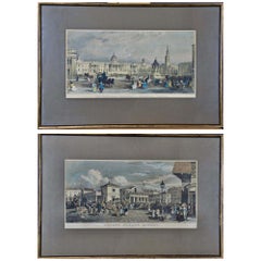
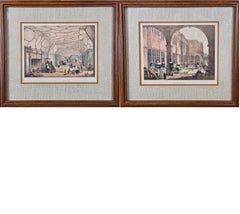
Views of London: A Pair of Framed 19th Century Engravings by Havell and Allom
Located in Alamo, CA
This is a pair of framed hand-colored prints, both utilizing engraving and etching techniques, depicting two London architectural landmarks: "The National Gallery, Charing Cross" and "Covent Garden Market" from the Stationers' Almanac, published in London by J. Robins & Sons in the early 19th century. Both of these prints show vibrant London street scenes with markets, carriages, common people as well as the wealthy in the foreground of "Covent Garden Market" and wealthy well dressed people, carriages, a begger, street merchants, as well as uniformed military on horseback in the foreground of "The National Gallery". "The National Gallery, Charing Cross" was created by James Sands from a painting by Thomas Allom (1804-1872), published in 1836. "Covent Garden Market" was created by Frederick James Havell (1801–1840/41) after a painting by William Havell...
Category
Mid-19th Century Naturalistic Landscape Prints
Materials
Engraving, Etching
"New Mackrel": An Engraving From the 18th Century Series 'The Cries of London'
By Francis Wheatley
Located in Alamo, CA
This is a beautifully framed engraving, printed in colors with additional hand coloring, from the famous "Cries of London" series, depicting the lives and professions of the common p...
Category
Late 18th Century Naturalistic Figurative Prints
Materials
Engraving
A Pair of Framed 19th Century Colored Lithographs of Tudor Scenes by Joseph Nash
By Joseph Nash
Located in Alamo, CA
This is a pair of framed 19th century tinted lithographs with hand-coloring entitled "Gallery Over the Hall, Knowle, Kent" and "Terrace Bramshill, Hants" by Charles Joseph Hullmandel (1789-1850) after drawings by Joseph Nash (1809-1878), from "Mansions of England in the Olden Time", published in London in 1839-1849. Nash's publication consists of a series of views of Tudor domestic architecture, which Nash said depicted "the most characteristic features of the domestic architecture of the Tudor Age, and also illustrating the costumes, habits, and recreations of our ancestors." The scenes of the aristocratic ladies and gentlemen (including Henry VIII and Queen Elizabeth I), who are depicted inhabiting the rooms of these great houses, were taken directly from the portraits on the walls.
Charles Joseph Hullmandel, was involved in the creation of these lithographs. He was a famous British lithographer, who invented the "lithotint" process, which he named and patented in 1840. This technique, allowing for greater nuance and value gradation than pure lithography, was an ideal means of expression for Nash's historically rich and picturesque depictions of Tudor mansions and their inhabitants. Hullmandel is also remembered for creating many lithographs from the paintings by J. M. W. Turner.
The "Gallery Over the Hall" depicts a great hall with children playing with skittles (wooden pins resembling bowling pins), a doll and what looks to be a St Charles spaniel, while a lady in Tudor attire watches over them next to a massive stone fireplace. Adults are watching from in the distance while a man bows...
Category
Late 19th Century Romantic Interior Prints
Materials
Lithograph
Fresh Gathered Peas: An 18th C. Engraving From the Series 'The Cries of London'
By Francis Wheatley
Located in Alamo, CA
This is a beautifully framed engraving, printed in colors with additional hand coloring, from the famous "Cries of London" series, depicting the lives and professions of the common p...
Category
Late 18th Century Naturalistic Figurative Prints
Materials
Engraving
Four Koa Wood Framed 18th C. Engravings from Captain Cook's 3rd Voyage Journal
By John Webber
Located in Alamo, CA
A grouping of four framed engravings of Hawaii, Tahiti, Tonga and Vancouver Island from the atlas of the official British Admiralty sanctioned journal of Captain Cook's 3rd Voyage entitled "A Voyage to the Pacific Ocean Undertaken by the Command of His Majesty, for Making Discoveries in the Northern Hemisphere", published upon completion of the voyage in London in 1784 by Strahan & Cadell. These engravings were made from drawings by John Webber (1752-1793), who was the artist on Captain James Cook's 3rd and final voyage of discovery. The set of engravings includes: "A Canoe of the Sandwich Islands, the Rowers Masked", Plate 65 in the atlas; "A Dance in Otaheite" (Tahiti), Plate 28; "King of the Friendly Islands" (Tonga), plate 20; "Inside of a House in Nootka Sound" (Canada), plate 42.
These engravings are professionally framed in Koa wood, the same wood as was used to make the canoes of the ancient Hawaiians. Koa wood is legendary in Hawaii. Not only is this amazing wood native to Hawaii, but it is known for the deep rich colors and varied grain pattern. Koa has an honored heritage in Hawaii and is highly revered and sacred. The word “koa” means “warrior” in Hawaiian. The warriors of King Kamehameha the Great, created canoes and weapons from a wood plentiful on the Big Island of Hawaii. This wood became synonymous with the warriors themselves, and it became known as koa.
These four engravings would make a wonderful grouping for a display of 2, 3 or 4 prints. They may be purchased separately or in groups on 1stDibs. Their listing Reference #'s are: LU117324682432, LU117324682022, LU117324684052 and LU117324684062. A discount is available for a grouping depending on the number of items included.
Hawaii was discovered by Captain Cook (1728-1779) during this voyage. Hawaii was originally called The Sandwich Islands in honor of The Earl of Sandwich...
Category
1780s Other Art Style Landscape Prints
Materials
Engraving
You May Also Like
William Hogarth, The Four Times of the Day - Set of 4
By William Hogarth
Located in Savannah, GA
William Hogarth
(British, 1697-1764)
William Hogarth’s The Four Times of the Day engravings, 19th century after the originals of 1738.
sight: 16 by 19 ¾ inches
frame: 18 by 21 ½ in...
Category
Antique 19th Century English Prints
Materials
Glass, Wood, Paper
"A Harlot's Progress" Plate 3 Etching
By William Hogarth
Located in Houston, TX
Etching from the series titled "A Harlots Progress" by William Hogarth. The series consists of six paintings and engravings. The story is about a woman named M. Hackabout who arrived in London and started working as a prostitute. The third plate is of her getting arrest for her choice in profession. The series is a satirical story that emphasizes the dangers of being a prostitute and the health risks that come from it.
In 18th century engraving, the detail of the black mole on women and men's face is a symbol of the deadly venereal disease, syphilis. In this plate, Hackabout has already contracted the disease and that is why the black dot is visible on her forehead as well as her madam's.
In 1828, William Innell Clement published Harlot's Progress in columns on a single page of his newspaper Bell's Life in London #330. The detail with the cross seen in earlier reproductions of the engraving.
Dimensions without Frame: H 14.5 in x W 16.5 in.
Artist Biography: William Hogarth ( 10 November 1697 – 26 October 1764) was an English painter, printmaker, pictorial satirist, social critic, and editorial cartoonist. His work ranged from realistic portraiture to comic strip-like series of pictures called "modern moral subjects", perhaps best known to be his moral series A Harlot's Progress, A Rake's Progress and Marriage A...
Category
1730s Old Masters Figurative Prints
Materials
Etching
Set of 6 Original Antique Prints After William Hogarth, "Marriage A La Mode"
By William Hogarth
Located in St Annes, Lancashire
Wonderful set of Hogarth prints
This is the " Marriage A La Mode " series typical of the satirical/political artwork of Hogarth
Steel engravings
Published by Jones & Co., Temple ...
Category
Antique 1840s English Rococo Prints
Materials
Paper
William Hogarth - 'Before and After' 2 Plate Etchings
By James Heath / William Hogarth
Located in Alpha, NJ
'Before and After' William Hogarth Etchings
Category
Antique 19th Century English Prints
Materials
Paper
$980 Sale Price / set
30% Off
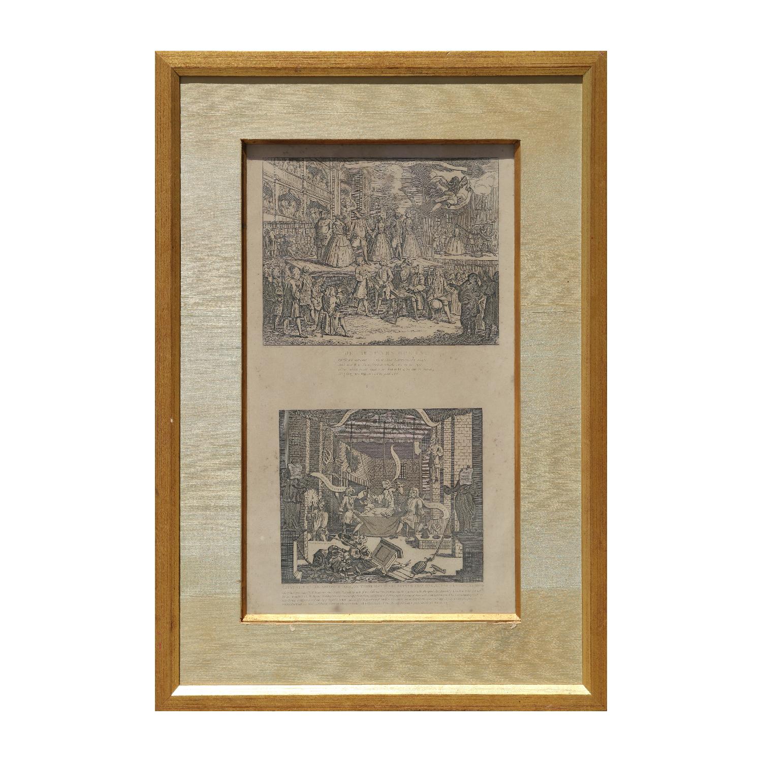
"The Beggars Opera" and " A Just View of The British Stage" Original Etchings
By William Hogarth
Located in Houston, TX
The original design for the top half was formally attributed to William Hogarth, according to the Met Museum, and published by John Bowles in 1728. The edition here has a second half...
Category
1820s Baroque Figurative Prints
Materials
Etching
William Hogarth, Harlot's Progress, Litographs with French Comments
Located in Leuven , BE
About the artist
William Hogarth (10 November 1697 – 26 October 1764) was an English painter, printmaker, pictorial satirist, social critic, and editorial cartoonist. His work ranges from realistic portraiture to comic strip-like series of pictures called "modern moral subjects", He is perhaps best known for his series A Harlot's Progress, A Rake's Progress and Marriage A-la-Mode. Knowledge of his work is so pervasive that satirical political illustrations...
Category
20th Century European Decorative Art
Materials
Paper
More Ways To Browse
Men Of The Day
Antique Frames Set Of Four
William Cross
The Antique Inn
Antique Cold Frame
Thomas Earl
Antique Master Clock
Antique Bombs
Antique End Of Day Glass
Cow Head
Small Antique Barrel
Antique Dog Plates
Used Floor Clocks
Pie Cut
Antique Equestrian Prints
Antique Restaurant Signs
George Barrel
British Antique Clocks