Items Similar to 1947 original map "Les eaux-de-vie de France - Le Cognac petite Champagne"


Want more images or videos?
Request additional images or videos from the seller
1 of 8
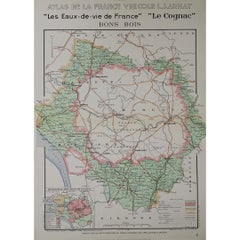
Louis Larmat1947 original map "Les eaux-de-vie de France - Le Cognac petite Champagne"1947
1947
$1,192.91
£881.93
€1,000
CA$1,640.83
A$1,823.89
CHF 956.04
MX$22,274.06
NOK 11,935.63
SEK 11,229.20
DKK 7,612.98
About the Item
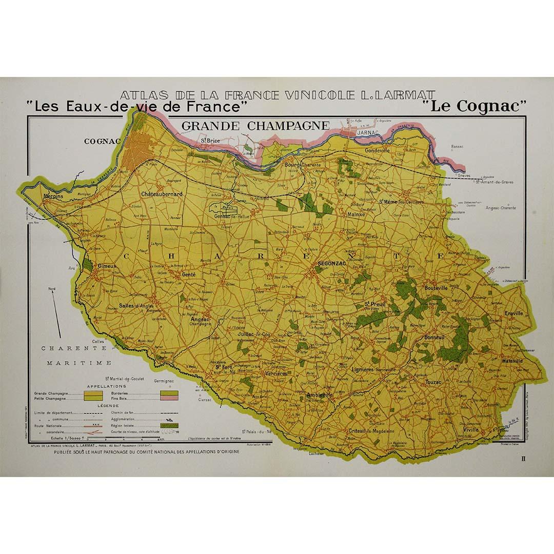
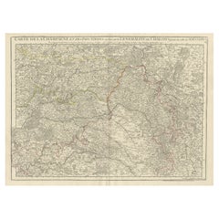
The 1947 original map Atlas de la France Vinicole - Les eaux-de-vie de France - Le Cognac Petite Champagne et Borderies, created by Louis Larmat and printed by Dorel in Paris, is a detailed and captivating representation of two of the key Cognac-producing regions in France: Petite Champagne and Borderies. This map is part of the renowned Atlas de la France Vinicole, a collection of maps that meticulously charted France’s wine and spirit-producing regions. Larmat’s work stands out for its combination of technical accuracy, geographical detail, and artistic beauty, making it a valuable resource for both professionals and collectors alike.
Louis Larmat was a prominent French cartographer known for his specialized focus on mapping France’s viticultural and spirit-producing regions. His Atlas de la France Vinicole series, published in the 1940s, is considered one of the most comprehensive and visually appealing collections of wine and spirits maps. These maps provide both an educational resource for those in the industry and a cultural artifact that celebrates France’s deep connection to its terroir. The Petite Champagne et Borderies map specifically highlights these two Cognac-producing sub-regions, offering insight into their importance within the broader Cognac landscape.
The Les eaux-de-vie de France - Le Cognac Petite Champagne et Borderies map showcases the geographical layout of these two distinct Cognac-producing areas. Petite Champagne is located to the south of the Grande Champagne region, and it is known for producing high-quality Cognac with excellent aging potential. Borderies, the smallest and oldest of the Cognac crus, is situated to the north of Cognac and produces eaux-de-vie with a more floral character, often prized for its roundness and smoothness.
The map provides a visual breakdown of the terroir in these regions, showing their boundaries, key villages, rivers, and other geographical features that contribute to the unique qualities of the Cognac produced there. Larmat’s map carefully delineates the contours of these regions, emphasizing the role of geography and soil composition in defining the characteristics of Cognac. Petite Champagne, with its chalky soils, and Borderies, with its clay and flint-rich earth, are both represented in this map in a way that highlights their importance in the overall production process.
In addition to the geographic layout, Larmat’s map often includes annotations that provide further details about the characteristics of each region’s eaux-de-vie. These notes help to explain the unique qualities of Cognac from Petite Champagne and Borderies, particularly their flavor profiles, aging potential, and typical aromas. Such information is valuable for those looking to understand the nuances between different Cognac-producing areas, underscoring the impact of terroir on the final product.
The map is also visually striking, with its hand-colored accents and artistic flourishes. Larmat’s use of color helps to distinguish between the regions, with Petite Champagne and Borderies each marked by different shades, allowing for easy identification of their boundaries. The artistry in the map’s design enhances its aesthetic appeal, making it not only a functional tool but also a work of art that is appreciated by collectors and connoisseurs of French vinicultural history.
The typography used on the map is clear and elegant, with the names of regions, villages, and other landmarks carefully placed to enhance readability. The map’s borders often include decorative elements that celebrate the subject matter, such as illustrations of vineyards, barrels, or grapevines, which further emphasize the connection between geography and the production of Cognac.
Maps like Larmat’s were created during a time when French viticulture and spirit production were regaining their prominence on the world stage. After the disruptions of World War II, there was a concerted effort to revive and promote France’s agricultural and artisanal industries. The Petite Champagne et Borderies map reflects this broader cultural movement, serving both as a practical tool for those involved in the Cognac industry and as a promotional piece that highlighted the heritage and prestige of French brandy.
The map was used not only by producers and merchants but also by educators and enthusiasts who sought to deepen their understanding of Cognac’s geographic and cultural roots. The clear delineation of different Cognac-producing areas on the map helped to reinforce the idea that Cognac’s quality and character were inherently tied to the land from which it originated. This connection between terroir and the final product remains a key principle in the production of Cognac today.
Today, Louis Larmat’s Petite Champagne et Borderies map from 1947 is a highly sought-after collectible for those interested in the history of French spirits and cartography. Its historical significance, coupled with its artistic beauty, makes it a prized possession for collectors, connoisseurs, and institutions dedicated to preserving France’s cultural heritage. The map provides a window into the post-war period when France was reasserting its global leadership in the production of fine wines and spirits, with Cognac at the forefront.
Larmat’s map not only serves as a functional reference for understanding the geography of Cognac production but also stands as a testament to the enduring importance of French terroir. It captures a moment in time when the tradition of Cognac-making was both a symbol of national pride and a crucial element of France’s cultural and economic recovery.
The 1947 Atlas de la France Vinicole - Les eaux-de-vie de France - Le Cognac Petite Champagne et Borderies map by Louis Larmat remains a remarkable example of mid-20th-century cartography and vinicultural documentation. Printed by Dorel in Paris, this map is a celebration of the artistry and precision that defines France’s approach to both mapmaking and spirit production. Its detailed depiction of two key Cognac regions continues to be of value to historians, industry professionals, and collectors who appreciate the intricate connection between land, culture, and craft in the production of one of the world’s finest spirits.
Original Poster
Alcohol - Map - Charente - France
Dorel - Paris
- Creator:Louis Larmat
- Creation Year:1947
- Dimensions:Height: 24.81 in (63 cm)Width: 17.72 in (45 cm)
- Medium:
- Period:
- Condition:Good condition, original folds.
- Gallery Location:PARIS, FR
- Reference Number:1stDibs: LU1792215285472
About the Seller
5.0
Gold Seller
Premium sellers maintaining a 4.3+ rating and 24-hour response times
Established in 2021
1stDibs seller since 2022
171 sales on 1stDibs
Typical response time: 1 hour
- ShippingRetrieving quote...Shipping from: PARIS, France
- Return Policy
Authenticity Guarantee
In the unlikely event there’s an issue with an item’s authenticity, contact us within 1 year for a full refund. DetailsMoney-Back Guarantee
If your item is not as described, is damaged in transit, or does not arrive, contact us within 7 days for a full refund. Details24-Hour Cancellation
You have a 24-hour grace period in which to reconsider your purchase, with no questions asked.Vetted Professional Sellers
Our world-class sellers must adhere to strict standards for service and quality, maintaining the integrity of our listings.Price-Match Guarantee
If you find that a seller listed the same item for a lower price elsewhere, we’ll match it.Trusted Global Delivery
Our best-in-class carrier network provides specialized shipping options worldwide, including custom delivery.More From This Seller
View All1947 original map "Les eaux-de-vie de France - Le Cognac" by Larmat
Located in PARIS, FR
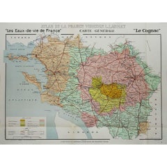
The 1947 original map Atlas de la France vinicole - Les eaux-de-vie de France - Le Cognac, created by Louis Larmat and printed by Dorel in Paris, is a fascinating and detailed cartog...
Category
1940s Prints and Multiples
Materials
Lithograph, Paper
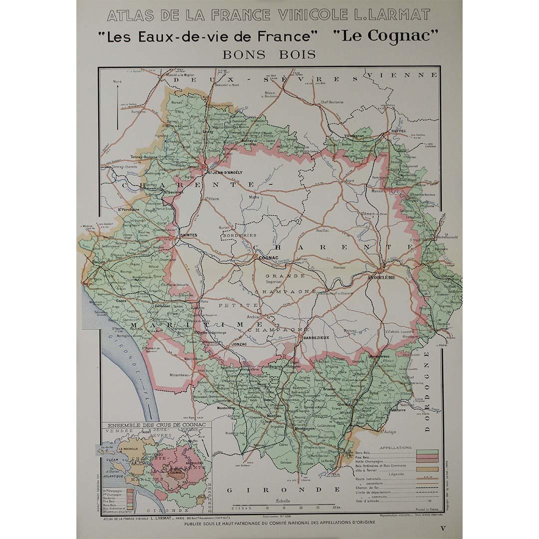
1947 original map "Les eaux-de-vie de France - Le Cognac Bons Bois" by Larmat
Located in PARIS, FR
The 1947 original map Atlas de la France Vinicole - Les Eaux-de-vie de France - Le Cognac Bons Bois, created by Louis Larmat and printed by Dorel in Paris, is a beautifully crafted c...
Category
1940s Prints and Multiples
Materials
Lithograph, Paper
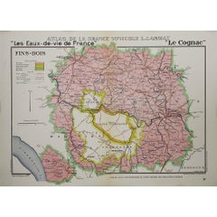
1947 original map "Les eaux-de-vie de France - Le Cognac fins bois" by Larmat
Located in PARIS, FR
The 1947 original map Atlas de la France Vinicole - Les Eaux-de-vie de France - Le Cognac Fins Bois, created by Louis Larmat and printed by Dorel in Paris, is an exquisite piece that...
Category
1940s Prints and Multiples
Materials
Lithograph, Paper
1947 original map "Les eaux-de-vie de France - Le Cognac" by Larmat
Located in PARIS, FR
The 1947 original map Atlas de la France vinicole - Les eaux-de-vie de France - Le Cognac, created by Louis Larmat and printed by Dorel in Paris, is a fascinating and detailed cartog...
Category
1940s Prints and Multiples
Materials
Lithograph, Paper
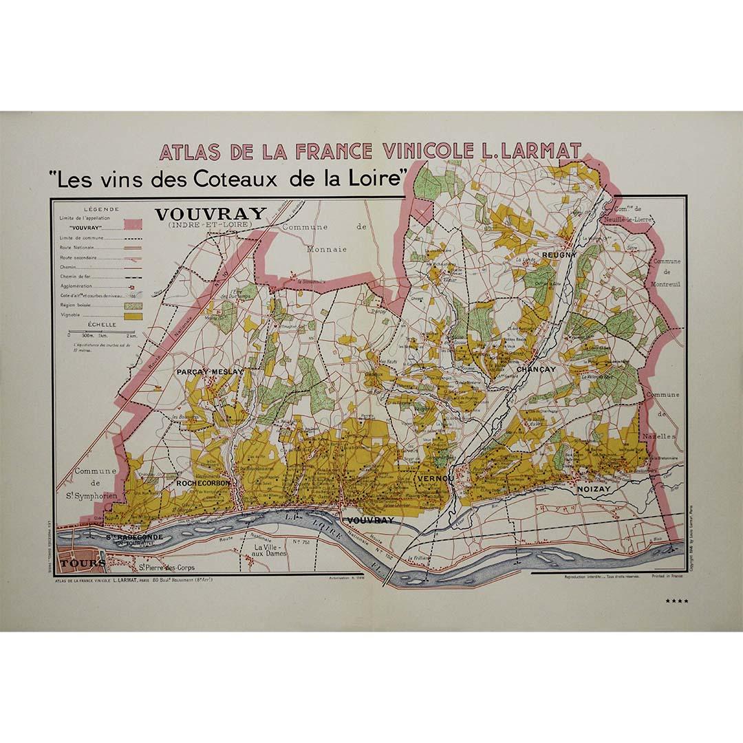
1946 original map "Les vins des côteaux de la Loire - Vouvray " by Larmat
Located in PARIS, FR
The 1946 map titled Atlas de la France Vinicole - Les Vins des Côteaux de la Loire: Vouvray by Louis Larmat, printed by Dorel in Paris, presents an intimate exploration of one of the...
Category
1940s Prints and Multiples
Materials
Lithograph, Paper

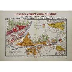
1946 original map "Les vins des côteaux de la Loire - Bourgueil" by Larmat
Located in PARIS, FR
The 1946 original map Atlas de la France Vinicole - Les Vins des Côteaux de la Loire: Bourgueil, St Nicolas-de-Bourgueil, Chinon, Montlouis, Jasnières, created by Louis Larmat and pr...
Category
1940s Prints and Multiples
Materials
Lithograph, Paper
You May Also Like
Antique Map of Champagne and surrounding Regions, France
Located in Langweer, NL
Antique map titled 'Carte de la Champagne et des Pays Voisins (..)'. Detailed map of Champagne and surrounding regions of Chalons and Soissons, Reims,...
Category
Antique Mid-18th Century Maps
Materials
Paper
Antique Map of France by Johnston (1909)
Located in Langweer, NL
Antique map titled 'France'. Original antique map of France. With inset maps of France in provinces, part of the Riviera and Corsica. This map or...
Category
Early 20th Century Maps
Materials
Paper

$238 Sale Price
20% Off
Original Vintage Poster Vignobles De France Vins Du Val De Loire Valley Wine Map
Located in London, GB
Original vintage drink advertising poster promoting French wines (one of a series issued by the Comite National de Propagande en Faveur du Vin national committee for the promotion of...
Category
Vintage 1950s French Posters
Materials
Paper
Original Vintage Poster Vineyards Of Champagne Wine Map Les Vignobles De France
Located in London, GB
Original vintage advertising poster for Les Vignobles de France Vins de Champagne / The Vineyards of France Wines of Champagne featuring a pictogra...
Category
Vintage 1960s French Posters
Materials
Paper
Antique Map of Vienne 'France' by V. Levasseur, 1854
By Victor Levasseur
Located in Langweer, NL
Antique map titled 'Dépt. de la Vienne'. Decorative antique map of the French Department of Vienne, with its capital of Poitiers and small engraved vignette of the battle of Poitiers...
Category
Antique Mid-19th Century Maps
Materials
Paper

$171 Sale Price
20% Off
Antique Map of Haute-Saone, France by V. Levasseur, 1854
By Victor Levasseur
Located in Langweer, NL
Antique map titled 'Dépt. de la Hte. Saône'. Map of the French department of Haute-Saone, France. Part of France's important Burgundy or Bourgogne Wine Region. This area is home to t...
Category
Antique Mid-19th Century Maps
Materials
Paper
$171 Sale Price
20% Off
More Ways To Browse
French Prints Floral
Vintage Champagne Art
Used Wine Barrels
Vintage French Poster Wine
Vintage Agricultural Poster
French Grande Poster
Vintage Alcohol Posters
French Poster Art Alcohol
Champagne Poster
Vineyard Poster
Vintage Barrel Stand
Wine Region Poster
French Champagne Posters
Cartographer Tool
Vintage Champagne Poster
Louis Cognac
Original Vintage Champagne Posters
Vintage Wine Barrels