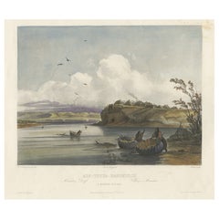
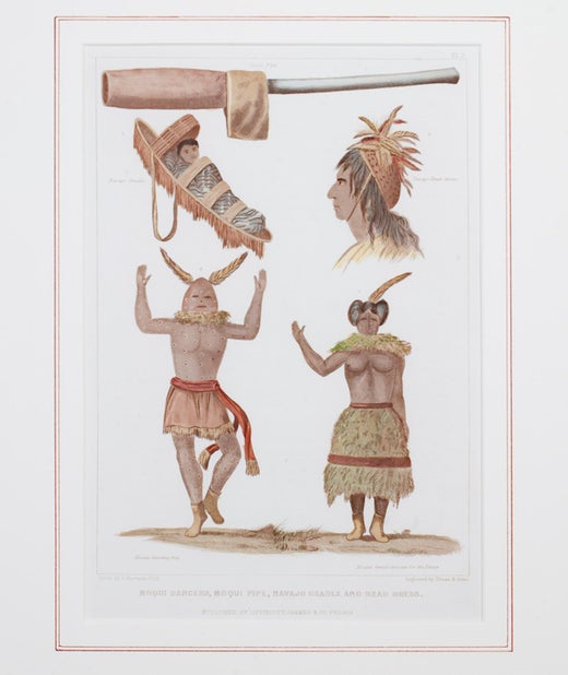
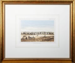
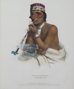
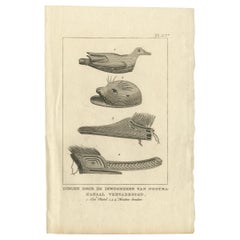
Want more images or videos?
Request additional images or videos from the seller
1 of 10

Seth Eastman
"Coin Beads--Western US Wilderness Expedition, " Color Lithograph by Seth Eastman

1847

$475
£360.77
€416.81
CA$665.73
A$745.08
CHF 388.87
MX$9,086.09
NOK 4,977.04
SEK 4,711.41
DKK 3,110.62
Shipping
Retrieving quote...
The 1stDibs Promise:
Authenticity Guarantee,
Money-Back Guarantee,
24-Hour Cancellation

About the Item

"Coin Beads - Western US Wilderness Expedition of 1847" is a color lithograph by Seth Eastman. It depicts various Native American beads used as currency and was published as an illustration to the 1850 Government Report. 8 1/4" x 5 1/2" art 19 3/8" x 17" frame Painter Seth Eastman is known primarily for his depictions of daily life among the Dakota and Ojibwa tribes in Minnesota. He was born to Robert and Sarah Lee Eastman on January 24, 1808, in Brunswick, Maine. Eastman attended the United States Military Academy at West Point, New York, where he received training in sketching and topography. While at West Point, he began to paint scenes featuring the daily life of local Native American tribes. In 1830 Eastman was assigned to topography duty on the frontier and spent a short time at Fort Snelling before returning to West Point to teach. While at Fort Snelling, Eastman married Wakaninajinwin (Stands Sacred), the fifteen-year-old daughter of Cloud Man, a Dakota chief. Eastman left in 1832 for another military assignment soon after the birth of their baby girl, Winona, and declared his marriage ended when he left. Winona was also known as Mary Nancy Eastman and was the mother of Charles Alexander Eastman, author of Indian Boyhood. From 1833 to 1840, Eastman taught drawing at West Point. In 1835 he married his second wife, Mary Henderson, the daughter of a West Point surgeon. In 1841 he returned to Fort Snelling as a military commander and remained there with Mary and their five children for the next seven years. It was during this time that Eastman began visually recording the everyday way of life of the Dakota and Ojibwa people. His wife Mary also became involved in preserving Indian culture by writing books on local tales and legends, which he would illustrate for her. The most important of these books was entitled Dacotah, or Life and Legends of the Sioux Around Fort Snelling. The Prairie Opposite Nauvoo, 1848. Location No. AV1988.45.277, Negative No. 21167In 1847 Henry R. Schoolcraft, a former Indian agent, was chosen to conduct a study of the American Indian people. Eastman illustrated the six-volume set, published between 1851 and 1857 as Historical and Statistical Information Respecting the History, Condition, and Prospects of the Indian Tribes of the United States. The U.S. House of Representatives Committee on Military Affairs also commissioned Eastman to paint images of seventeen important military forts, which he completed between 1870 and 1875. These paintings are now housed in the Capitol Building in Washington, D.C. Eastman died of a stroke while painting at his home in Washington, D.C., on August 31, 1875. Eastman's works are significant for Minnesota history because art historians believe that Eastman based many of his paintings and sketches on his observations in the Sioux villages of Kaposia and Little Crow, as well as in Scott, Wabasha, and Winona counties.
  • Creator:
    Seth Eastman (1808 - 1875, American)
  • Creation Year:
    1847
  • Dimensions:
    Height: 19.375 in (49.22 cm)Width: 17 in (43.18 cm)
  • Medium:
  • Period:
  • Condition:
  • Gallery Location:
    Milwaukee, WI
  • Reference Number:
    Seller: 10799g1stDibs: LU60533142953

More From This Seller

View All
19th century color engraving indigenous figures feathers text full body face
By Seth Eastman
Located in Milwaukee, WI
"Moqui Dancers, Moqui Pipe, Navajo Cradle & Headdress" is a hand-colored engraving by Seth Eastman. It depicts encyclopedic depictions of Native American...
Category

1840s More Prints

Materials

Engraving

'Camp Red River Hunters' original lithograph by John Mix Stanley
By John Mix Stanley
Located in Milwaukee, WI
In the mid-nineteenth century, the United States government set out to survey and document its newly acquired lands and territories west of the Mississippi. The goals of these surveys were manifold: to produce topographical maps, to document flora and fauna, and to document natural resources to build the emerging US economy. These surveys, and the images from them, also functioned to build the new sense of American identity with the landscape, condensing vistas into the 'picturesque' tradition of European image making. Thus, the entire span of US territory could be seen as a single, cohesive whole. This lithograph comes from one of six surveys commissioned by the Army's Topographic Bureau in 1853, which sought to find the best route to construct a transcontinental railroad. The result was a thirteen-volume report including maps, lithographs, and technical data entitled 'Explorations and Surveys to ascertain the most practicable and economical route for a Railroad from the Mississippi river to the Pacific Ocean.' In particular, the print comes from the northern survey, commanded by Isaac Stevens, which explored the regions between the 47th and 49th parallels. In this image, Stanley shows an encampment of the people known as the Red River of the North hunters. They were generations of European and mixed-race trappers who lived on the frontier and had Indian wives and mixed-race children. They had come to the area for bison hunting, as the herds were still vast on the prairies. In the image, the figures and their encampment are dwarfed by the vast landscape around them, indicating the sublimity of these new American territories. 5.75 x 8.75 inches, image 6.5 x 9.25 inches, stone 17 x 20 inches, frame Artist 'Stanley Del.' lower left Entitled 'Camp Red River Hunters' lower center margin Publisher 'Sarony, Major & Knapp. Lith.s 449 Broadway N.Y.' lower right Inscribed 'U.S.P.R.R. EXP. & SURVEYS — 47th & 49th PARALLELS' upper left Inscribed 'GENERAL REPORT — PLATE XII' upper right Framed to conservation standards using 100 percent rag matting with French accents; glazed with UV5 Plexiglas to inhibit fading; housed in a gold reverse ogee moulding. Print in overall good condition; some localized foxing and discoloration; minor surface abrasions to frame. John Mix Stanley...
Category

1850s Romantic Landscape Prints

Materials

Lithograph

'Distribution of Goods to the Assiniboines' original John Mix Stanley lithograph
By John Mix Stanley
Located in Milwaukee, WI
In the mid-nineteenth century, the United States government set out to survey and document its newly acquired lands and territories west of the Mississippi. The goals of these surveys were manifold: to produce topographical maps, to document flora and fauna, and to document natural resources to build the emerging US economy. These surveys, and the images from them, also functioned to build the new sense of American identity with the landscape, condensing vistas into the 'picturesque' tradition of European image making. Thus, the entire span of US territory could be seen as a single, cohesive whole. This lithograph comes from one of six surveys commissioned by the Army's Topographic Bureau in 1853, which sought to find the best route to construct a transcontinental railroad. The result was a thirteen-volume report including maps, lithographs, and technical data entitled 'Explorations and Surveys to ascertain the most practicable and economical route for a Railroad from the Mississippi river to the Pacific Ocean.' When it came to depicting the Assiniboine people, as seen in the present print, Stanley chose to juxtapose their encampment, marked by tipis in the distance, with the encampment of the Isaac Stevens survey party. In the foreground, commemorating this moment, Isaac Stevens can be seen presenting trade goods, which are known to include thirty two dressed skins and two robes. The survey leader Isaac Stevens noted being grateful for the generosity of the Assiniboine, commenting: "I felt very grateful indeed to those Indians, for their kindness to my men, their proffer of kind feeling and hospitality to myself and the survey." This description and this image, however, are arguably depicted through rose-colored glasses: to the Assiniboine people, this meeting may well have included stressful diplomatic relationships and have indicated a threat to the sovereignty over the territories agreed to be theirs by the 1851 Treaty of Fort Laramie. 5.75 x 8.75 inches, image 6.5 x 9.25 inches, stone 17 x 19.75 inches, frame Artist 'Stanley Del.' lower left Entitled 'Distribution of Goods to the Assiniboines' lower center margin Publisher 'Sarony, Major & Knapp. Lith.s 449 Broadway N.Y.' lower right Inscribed 'U.S.P.R.R. EXP. & SURVEYS — 47th & 49th PARALLELS' upper left Inscribed 'GENERAL REPORT — PLATE XIV' upper right Framed to conservation standards using 100 percent rag matting with French accents; glazed with UV5 Plexiglas to inhibit fading; housed in a gold reverse ogee moulding. Print in overall good condition; some localized foxing and discoloration; frame in excellent condition. John Mix Stanley...
Category

1850s Romantic Landscape Prints

Materials

Lithograph

'Maple River' original color lithograph by John Mix Stanley
By John Mix Stanley
Located in Milwaukee, WI
In the mid-nineteenth century, the United States government set out to survey and document its newly acquired lands and territories west of the Mississippi. The goals of these surveys were manifold: to produce topographical maps, to document flora and fauna, and to document natural resources to build the emerging US economy. These surveys, and the images from them, also functioned to build the new sense of American identity with the landscape, condensing vistas into the 'picturesque' tradition of European image making. Thus, the entire span of US territory could be seen as a single, cohesive whole. This lithograph comes from one of six surveys commissioned by the Army's Topographic Bureau in 1853, which sought to find the best route to construct a transcontinental railroad. The result was a thirteen-volume report including maps, lithographs, and technical data entitled 'Explorations and Surveys to ascertain the most practicable and economical route for a Railroad from the Mississippi river to the Pacific Ocean.' Along with the image, Stanley also noted in the report of the Maple River: "It would be an excellent plan for an emigrant travelling through the country, before reaching one of these rivers on which he expects to camp, to catch a few frogs, for the purpose of fishing in these streams, which abound pike, picarel, and large catfish. Frogs are by far the best bait that can be used." This note from the artist perhaps describes some of the actions of the figures in the camp in the foreground of the image. 5.75 x 8.75 inches, image 6.5 x 9.25 inches, stone 13.25 x 16.25 inches, frame Artist 'Stanley Del.' lower left Entitled 'Maple River' lower center margin Publisher 'Sarony, Major & Knapp. Lith.s 449 Broadway N.Y.' lower right Inscribed 'U.S.P.R.R. EXP. & SURVEYS — 47th & 49th PARALLELS' upper left Inscribed 'GENERAL REPORT — PLATE VIII' upper right Framed to conservation standards using 100 percent rag matting and Museum Glass to inhibit fading; housed in a brass-surface aluminium moulding. John Mix...
Category

1850s Romantic Landscape Prints

Materials

Lithograph

"Dahcota Mission of Peace 1820, Warning Against Tresspass, " by Seth Eastman
By Seth Eastman
Located in Milwaukee, WI
"Dahkota Mission of Peace 1820, Warning Against Tresspass" is a color lithograph by Seth Eastman. It features figures trying to warn people against trespassing on their land. 7 3/4...
Category

1840s More Prints

Materials

Lithograph

19th century color lithograph portrait indigenous male subject feathers signed
By McKenney & Hall
Located in Milwaukee, WI
"Wa-Em-Boesh-Kaa, A Chippeway Chief," is an original hand-colored lithograph by McKenney & Hall. It features a portrait of a notable Native American chief, with informational text below. 13 1/2" x 18 3/4" paper 25 5/8" x 20 1/2" frame American lithograph publishers. Most well-known for "History of the Indian Tribes of North America," a collection of 125 images that included biographical sketches and anecdotes of principal chiefs. Thomas Loraine McKenney (1785-1859) served as Commissioner of Indian Affairs from 1824 to 1830. In that capacity he commissioned and collected portraits of Native Americans...
Category

1830s Academic Portrait Prints

Materials

Lithograph

You May Also Like

Native North American Artefacts, German chromolithograph, circa 1895
Located in Melbourne, Victoria
German chromolithograph of native American artefacts. Circa 1895.
Category

Late 19th Century Naturalistic Portrait Prints

Materials

Lithograph

Antique Print with Decorations 'New Guinea, Indonesia' by Temminck, circa 1840
Located in Langweer, NL
Antique print titled 'Versierselen der Papoeas'. This print originates from 'Verhandelingen over de natuurlijke geschiedenis der Nederlandsche overzeesche bezittingen, door de Leden ...
Category

Antique Mid-19th Century Prints

Materials

Paper

Antique Print of Jewellery, Belts and other Items from Birara, New Ireland
Located in Langweer, NL
Antique print titled 'Ile Birara, Nouvelle-Irlande'. Jewellery, belts and other items from Birara Islands, New Ireland. Illustrated are a feather ornament,...
Category

Antique Mid-19th Century Prints

Materials

Paper

Antique Print of Various Objects of the Caroline Islands by Ferrario '1831'
Located in Langweer, NL
Original antique print of various objects of the Caroline Islands. This print originates from 'Costume Antico e Moderno: Palestine, China, India, Ocea...
Category

Antique Mid-19th Century Prints

Materials

Paper

Antique Print Depicting Various Items Produced by Natives by Cook, 1803
Located in Langweer, NL
Antique print titled 'Dingen door de Inwooneren van Nootka-Kanaal vervaardigd'. This print depicts various items, produced by Natives of Nootka, Canada. Originates from 'Reizen Rondo...
Category

Antique Early 19th Century Dutch Prints

Materials

Paper

Old Hand-Coloured Aquatint of a Mandan Village Near Fort Clark, Texas, ca.1840
Located in Langweer, NL
Antique print titled 'Mih-Tutta-Hangkusch'. Hand-coloured aquating of a Mandan village by Salathé after Bodmer. In response to raids by its neighbours, the Mandan Tribe consolidated its people in two main villages: Mih-Tutta-Hang-Kusch and Ruhptare. Mih-Tutta-Hang-Kusch, the larger of these, is represented here by Bodmer as it appeared in the summer of 1833. Close to Fort Clark, it consisted of sixty-five earth lodges or houses, many with scaffolding around the houses that was used for drying corn and other food. The village's position, high on a promontory jutting out into the Missouri, made it easily defensible. However, all is tranquil in this scene as the women in the foreground collect driftwood using...
Category

Antique 1840s Prints

Materials

Paper