Items Similar to 18th Century Map Engraving - Mechlin, or Malines
Want more images or videos?
Request additional images or videos from the seller
1 of 8
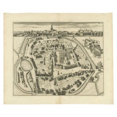
Unknown18th Century Map Engraving - Mechlin, or MalinesUnknown
Unknown
$269.60
$33720% Off
£207.04
£258.8020% Off
€237.27
€296.5820% Off
CA$379.53
CA$474.4120% Off
A$425.16
A$531.4520% Off
CHF 221.13
CHF 276.4220% Off
MX$5,186.05
MX$6,482.5620% Off
NOK 2,815.34
NOK 3,519.1820% Off
SEK 2,654.67
SEK 3,318.3320% Off
DKK 1,770.89
DKK 2,213.6220% Off
About the Item
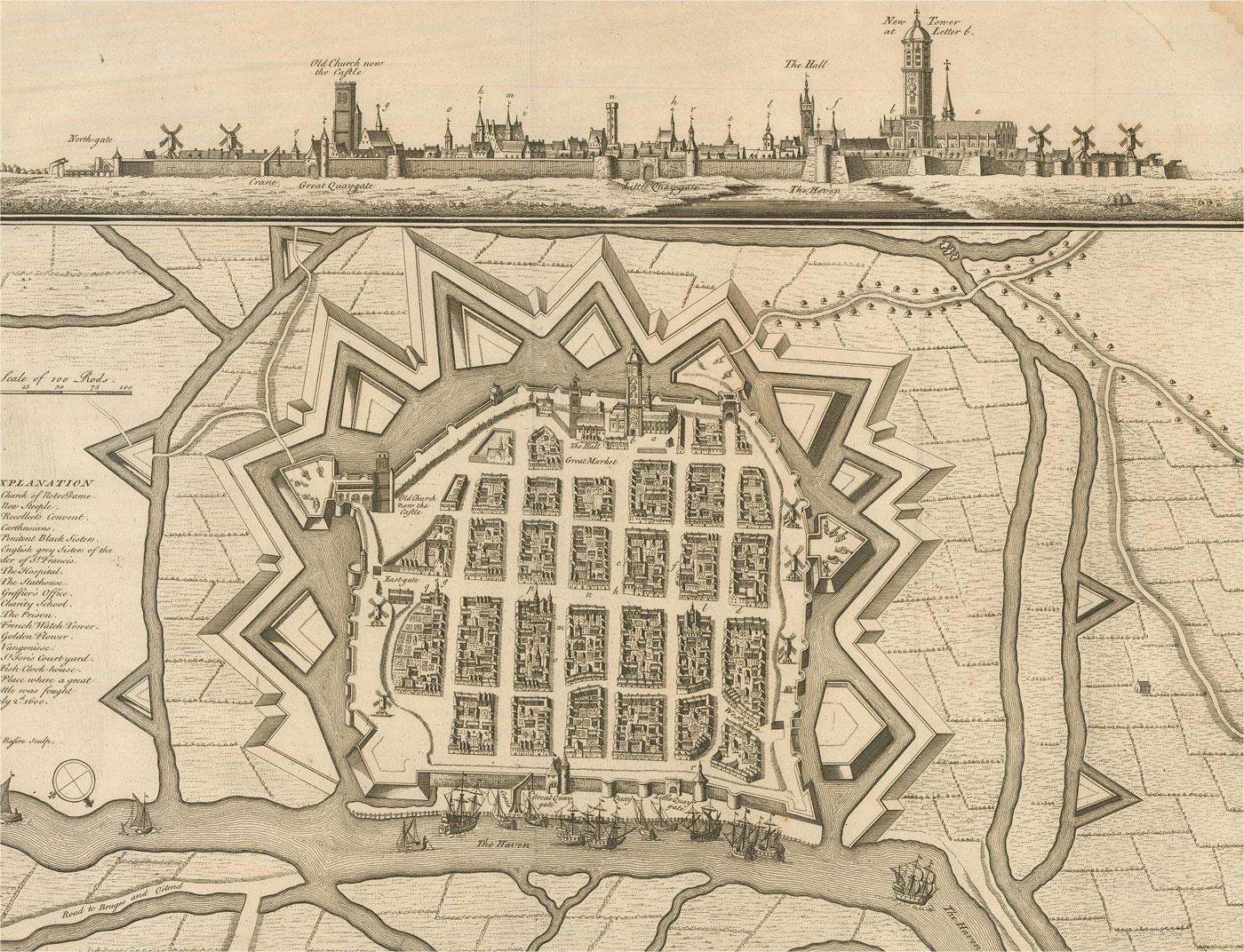
A map of Mechelen, known as Malines in French and Mechlin in English, a city and municipality in the province of Antwerp in the Flemish Region of Belgium. A birds-eye view plan of the city, it illustrates every street, building, and landmark, including the city's fortified walls which were ordered to be destroyed in 1781 by Joseph II, Holy Roman Emperor. Inscribed with the title in plate to the lower edge, 'Mechlin, or Malines the Capital of one of the ten Provinces of the Netherlands in Brabant an Archbishopric, situated upon the Dyle'. Engraved for 'Mr Tindal's Continuation of Mr Rapin's 'History of England'' with maps by Richard William Seale and John Basire and first published in 1727. This was a continuation of 'L'Histoire d'Angleterre' by Paul de Rapin-Thoyras (1661-1725) which was printed at the Hague in 1724. On laid.
- Creation Year:Unknown
- Dimensions:Height: 15.36 in (39 cm)Width: 19.3 in (49 cm)
- Medium:
- Period:
- Condition:There are several small closed tears around the edges. There is a centrefold crease and some mild foxing and discolouration around the edges. Cropped to the plate line at the upper-left edge.
- Gallery Location:Corsham, GB
- Reference Number:Seller: ra8371stDibs: LU881310269632
About the Seller
4.9
Gold Seller
Premium sellers maintaining a 4.3+ rating and 24-hour response times
Established in 2010
1stDibs seller since 2018
1,300 sales on 1stDibs
Typical response time: 3 hours
- ShippingRetrieving quote...Shipping from: Corsham, United Kingdom
- Return Policy
Authenticity Guarantee
In the unlikely event there’s an issue with an item’s authenticity, contact us within 1 year for a full refund. DetailsMoney-Back Guarantee
If your item is not as described, is damaged in transit, or does not arrive, contact us within 7 days for a full refund. Details24-Hour Cancellation
You have a 24-hour grace period in which to reconsider your purchase, with no questions asked.Vetted Professional Sellers
Our world-class sellers must adhere to strict standards for service and quality, maintaining the integrity of our listings.Price-Match Guarantee
If you find that a seller listed the same item for a lower price elsewhere, we’ll match it.Trusted Global Delivery
Our best-in-class carrier network provides specialized shipping options worldwide, including custom delivery.More From This Seller
View All18th Century Map Engraving - Newport, a Strong Sea-Port Town in Flanders
Located in Corsham, GB
A map of Nieuwpoort, anglicised to 'Newport', in northern Belgium. There is a panorama in the upper quarter depicting major landmarks. Below is a plan of the town, including its strong defences and ships at the port in the lower register. Inscribed with the title in plate to the lower edge, 'Newport a Strong Sea-Port Town...
Category
18th Century More Prints
Materials
Engraving

$269 Sale Price
20% Off
Henri Liebaux and Guillaume De L'Isle - 1706 Engraving, Map Of The Moscovites
Located in Corsham, GB
A early 18th Century map showing a section of Muscovite Russia. This is the lower half of the complete original map, finished with hand colouring. The artist's names are engraved in ...
Category
18th Century More Prints
Materials
Engraving
18th Century Map Engraving - Plan of the Works of the City of Messina, Sicily
Located in Corsham, GB
A map of Messina, a harbour city in northeast Sicily. Inscribed with the title in plate to the lower edge, 'Plan of the Works of the City of Messina, one of the strongest and most co...
Category
18th Century More Prints
Materials
Engraving

$285 Sale Price
20% Off
John Senex (1678-1740) - 18th Century Engraving, A New Map of Great Britain
By John Senex
Located in Corsham, GB
A New Map of Great Britain - Corrected from the Observations Communicated to the Royal Society at London. By John Senex F.R.S. A double-page engraved map on 2 sheets joined, with lat...
Category
18th Century More Prints
Materials
Engraving

After Johann B. Homann (1664-1724) - 19th C, General Map of Spain and Portugal
Located in Corsham, GB
General map of Spain and Portugal divided into its current provinces by D.T. Lopez, newly drawn by F. L. G. in Nuremberg at the Heret of Homann, 1782. A double-page engraved map with...
Category
19th Century More Prints
Materials
Engraving

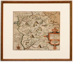
Christopher Saxton & William Kip - Framed 17th Century Engraving, Merionith
Located in Corsham, GB
An early copper-engraved county map of Merioneth, based on the work of Christopher Saxton (1540-1610), and engraved by William Kip (fl.1598-1610) for William Camden's 'Britannia'. Wi...
Category
18th Century More Prints
Materials
Engraving
You May Also Like
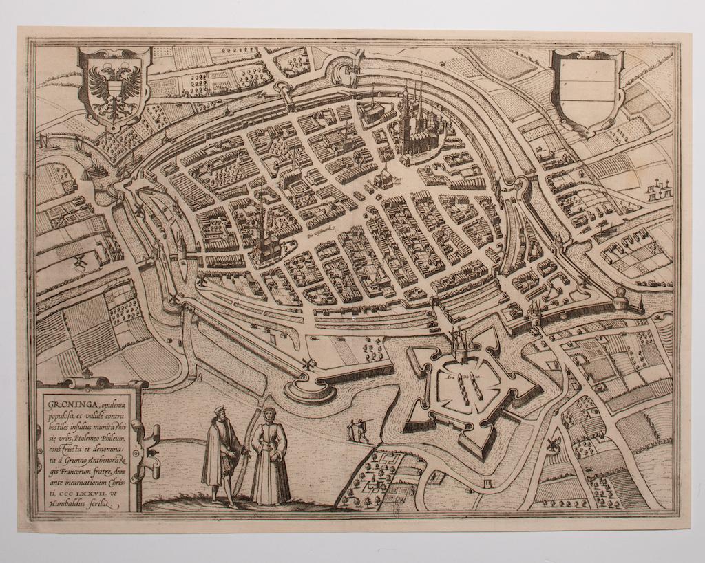
Map of Groningen - Etching by George Braun - Late 16th Century
Located in Roma, IT
This map of Groninga is an original etching realized by George Braun and Franz Hogenberg, and part of the series "Civitates Orbis Terrarum".
The state of preservation of the artwork...
Category
16th Century Figurative Prints
Materials
Etching

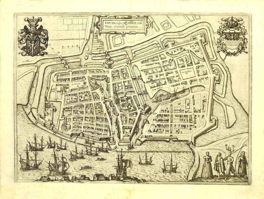
Map of Embden - Original Etching by G. Braun e F. Hogenberg - Late 16th Century
By Franz Hogenberg
Located in Roma, IT
This map of Embdena is an original etching realized by George Braun and Franz Hogenberg in the Late 16th Century, as part of the famous Series "Civitates Orbis Terrarum" (Atlas of t...
Category
16th Century Figurative Prints
Materials
Etching

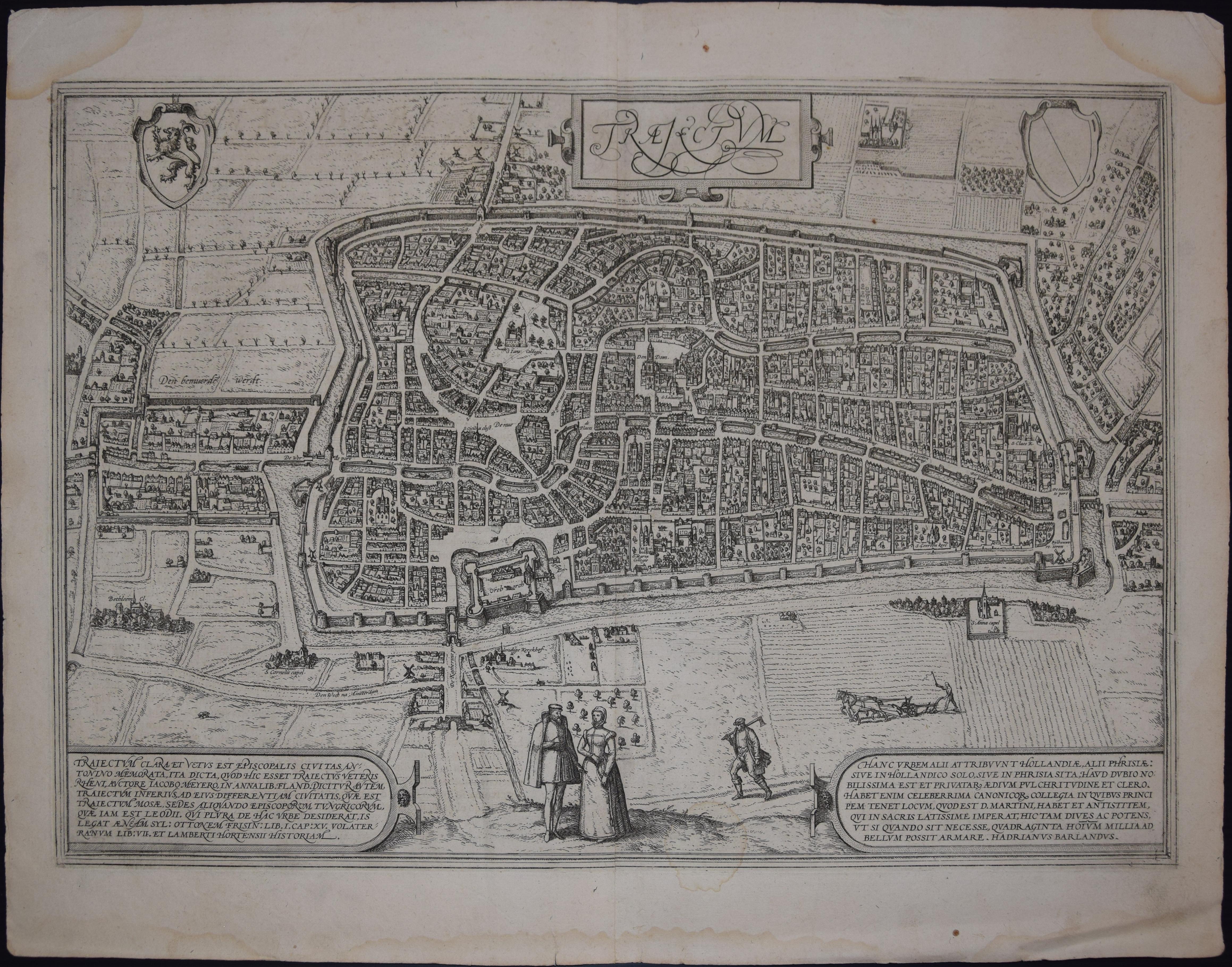
Utrecht, Antique Map from "Civitates Orbis Terrarum"
By Franz Hogenberg
Located in Roma, IT
Braun G., Hogenberg F., Traiectum or Utrecht, from the collection Civitates Orbis Terrarum, Cologne, T. Graminaeus, 1572-1617.
Very fine B/W aquatint showing a view of Utrecht, with...
Category
16th Century Landscape Prints
Materials
Etching

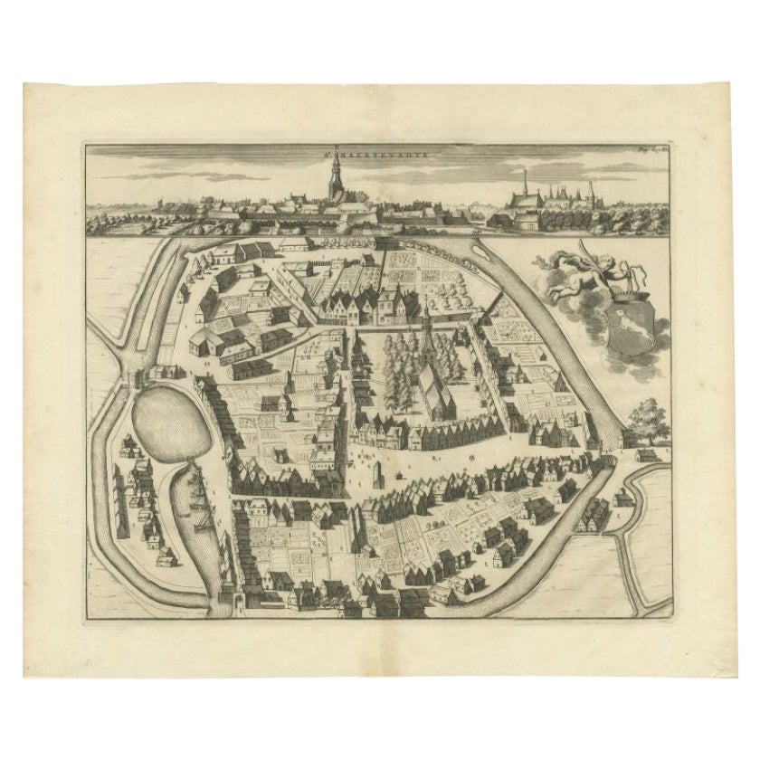
Antique Map of the City of Sint-Maartensdijk by Smallegange, c.1696
Located in Langweer, NL
Antique map titled 'St. Maertensdyk'. Original antique map of the city of Sint-Maartensdijk, the Netherlands. Source unknown, to be determined.
Artists and Engravers: Published b...
Category
Antique 17th Century Maps
Materials
Paper
$156 Sale Price
20% Off
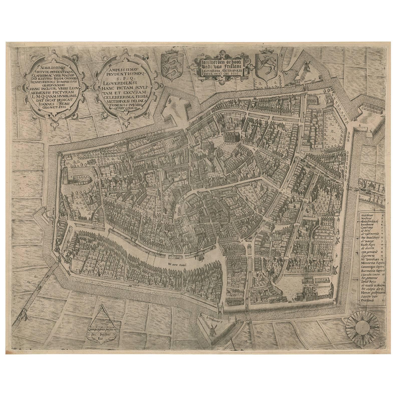
Rare Antique Map of Leeuwarden, Friesland, The Netherlands, by P. Bast, 1603
By P. Bast
Located in Langweer, NL
Very rare plan of Leeuwarden, Friesland, The Netherlands. With several cartouches and coat of arms. With a legend and compass rose at bottom right. Made by 'Pieter Bast' after the su...
Category
Antique Early 17th Century Maps
Materials
Paper

$3,457 Sale Price
35% Off
Antique Map of the City of Zutphen by Guicciardini, 1613
Located in Langweer, NL
Antique map Zutphen titled 'Zutphen'. This map depicts the city of Zutphen, Gelderland, The Netherlands. Originates from 'Discrittione di tutti i Paesi Bassi'.
Artists and Engrav...
Category
Antique 17th Century Maps
Materials
Paper
$158 Sale Price
20% Off
More Ways To Browse
18th Century French Prints
18th Century French Engraving
Capsule Sculpture
Warhol Gun
J Roberts Antiques
Pierre Joseph Redoute
Chad Sculpture
Marilyn Crying
Us Navy Poster
London Map Vintage
Rome Travel Poster
Communist Propaganda Art
The Wailing Wall
Vintage German China Marks
Namibian Sculpture
Valencia Poster
Original Vintage Champagne Posters
1964 Wine Vintage