George & John Cary Maps
to
1
1
1
1
1
1
1
1
1
1
1
1
3
104
63
28
24
Creator: George & John Cary
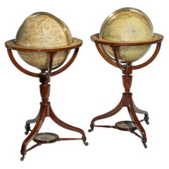
Fine Pair of Floor Globes by J & G Cary, Dated 1820 and 1833
By George & John Cary
Located in Lymington, Hampshire
A fine pair of 15 inch floor globes by J & G Cary, dated 1820 and 1833, each set into a mahogany stand with a vase shaped support and three legs centred on a compass, one with a labe...
Category
Early 19th Century English Regency Antique George & John Cary Maps
Materials
Mahogany
Related Items
Antique Hammond's 6-Inch Terrestrial Globe on Stand
By C.S. Hammond & Co.
Located in Philadelphia, PA
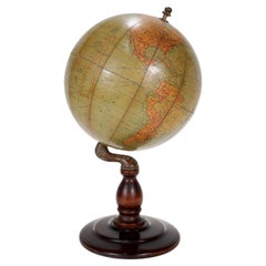
Offered here for your consideration is, A fine antique 6-inch terrestrial globe.
Additional Details:
By C.S. Hammond & Co.
The globe likely dates from 1927 to 1930 due to the ...
Category
20th Century Unknown Art Deco George & John Cary Maps
Materials
Wood, Paper
Antique World Globe From Fleet Street London 1923 on Wooden Stand
Located in Reading, Berkshire
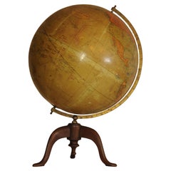
Antique Terrestrial Geographia of Fleet Street London 12"inch World Globe on handcrafted Wooden Three Legged Base 1923
Made 55 Fleet Street, London
Beautiful desktop globe, sho...
Category
1920s British Art Deco Vintage George & John Cary Maps
Materials
Wood, Paper
$1,339 Sale Price
25% Off
H 18.51 in Dm 11.82 in
English Campaign Trunk of Brass-Bound Leather and Camphor Wood, circa 1820
Located in Austin, TX
A handsome medium-sized British officer's military Campaign camphor trunk or chest of brass-bound and studded leather over camphor wood, circa 1820.
Manufactured by the British East India...
Category
Early 19th Century English Campaign Antique George & John Cary Maps
Materials
Brass, Metal
$3,495
H 13.13 in W 31.5 in D 16 in
19th Century German Miniature Pocket Terrestrial Globe
By C. Abel-Klinger
Located in Essex, MA
A miniature 19th century 3.5 inch diameter pocket terrestrial globe by C. Abel-Klinger, Nuremberg, Germany, in English for the English speaking markets. Signed with cartouche reading...
Category
1880s German Antique George & John Cary Maps
Materials
Brass
Floor Standing Globe On A Turned Hardwood & Brass Stand Model No 16
By Cram's
Located in Reading, Berkshire
Crams Imperial World Globe
Floor Standing Globe On A Turned Hardwood & Brass Stand Model No 16
Manufactured by George F Cram Co. Indiana, U.S.A
Category
Early 20th Century American Victorian George & John Cary Maps
Materials
Brass
$1,260 Sale Price
30% Off
H 34.26 in W 15.75 in D 14.97 in
Floor Model Light Up Globe by Replogle Ca. 1950/1960's
By Replogle Globes
Located in New York, NY
Exceptional light up floor model globe, by Replogle Globes Inc. The globe is 16 in. in diameter, it features an interior light, and restrain a solid mahogany frame. This example is i...
Category
Mid-20th Century American Mid-Century Modern George & John Cary Maps
Materials
Glass, Mahogany, Paper
1889s Antique Celestial Globe Signed Gussoni e Dotti Milano Papier Maché Sphere
Located in Milan, IT
Celestial globe compiled on the Hesi & Gould catalogs by Eng. Pini and published in 1889 by Gussoni & Dotti Milano piazza del Duomo. Sphere in paper mache covered with paper printed by engraving on copper plate and hand watercolored, base in turned and ebonized wood.
Good condition, conservative restoration at the base. Measures: Height 45 cm, inche 17.8, sphere diameter 22 cm 8.7.
Giovanni Gussoni in 1874 bought the business of Antonio Ronchi typographer in Via Unione 5 in Milan, and then moved in 1883 to the shop of the Southern Porticoes in Piazza Duomo. Giovanni Gussoni was followed by his son Vittorio, who on April 16, 1907 sold the company to a collaborator, Giovanni Serra, who continued the business until November 1914.
Man has always wanted to know the world in which he lives and has used all the means available to measure the space that surrounds him to expand his knowledge more and more. The conditions that allowed man to develop models of the world and space were probably realized only after...
Category
1880s Antique George & John Cary Maps
Materials
Paper
$3,002
H 8.7 in Dm 17.8 in
World Globe With Wooden Foot, and Brass 20th Century
Located in Mombuey, Zamora
Beautiful and elegant ball of the world to decorate any studio, living room or bedroom, it is small, with the base about 26 cm high and 10 wide.
Category
20th Century Italian Other George & John Cary Maps
Materials
Brass
$671 Sale Price
20% Off
H 14.57 in W 8.08 in D 8.08 in
English Pocket Globe, London, Circa 1775-1798
By Herman Moll
Located in Milano, IT
Pocket globe
London, between 1775 and 1798
Re-edition of the globe of Hermann Moll (1678-1732) dated 1719
The globe is contained in its original case, which itself is covered in shark skin.
There are slight gaps in the original paint on the sphere. The case no longer closes.
The sphere measures 2.7 in (7 cm) in diameter whereas the case measures 2.9 in (7.4 cm) in diameter.
lb 0.22 (kg 0.1)
The globe is made up of twelve printed paper gores aligned and glued to the sphere.
In the North Pacific Ocean there is a cartouche with the inscription:
A Correct
Globe
with the new
Discoveries.
The celestial globe is depicted on the inside of the box and is divided into two hemispheres with the cartouche:
A correct globe
with ye new cons
relations of Dr.
Halley & c.
It shows the ecliptic divided into the days of the zodiacal calendar and the constellations represented as animals and mythological figures.
On the globe are delineated the equinoctial line, divided by degrees and hours, the ecliptic and the meridian (passing west of Greenwich). The continents are shaded and outlined in pink, green and yellow. It shows: the Cook routes; a wind rose in the Southern Indian Ocean; Antarctica without land; Africa with Negroland (Hermann Moll is considered the first geographer to name the West African region in his 1727 map. (Encyclopaedia Britannica, ed. 1902, under "States of Central Africa"); Tartary in Central Asia; the Mogul kingdom in northern India; in North America only New England, Virginia, Carolina, Florida, Mississippi are identified; California is already a peninsula; the northwest coast of America is "unknown parts" (Alaska is not described and it is only partially delineated, it was to become part of the United States in 1867); Mexico is named "Spain"; Central South America "Amazone America". Australia (which was to be so named after 1829) is called New Holland. The route of Admiral Anson is traced (1740) and the trade winds are indicated by arrows. (See Van der Krogt, P., Old Globes in the Netherlands, Utrecht 1984, p. 146 and Van der Krogt, P. - Dekker, E., Globes from the Western World, London 1993, pp. 115.)
Elly Dekker, comparing Moll’s 1719 globe and his re-edition (of which the one described above is a sample), identifies the differences between them: the two editions are quite similar to each other, but in the "anonymous" globe, compared to the previous globe of 1719, California looks like a proper peninsula - the reports of the Spanish explorers of the region had given rise to uncertainty over whether it was connected to the mainland or not. The geographical nature of California was confirmed after the explorations of Juan Bautista de Anza (1774-1776). The routes of Dampier's journey were partially erased and the route of Captain James Cook's first voyage was superimposed on them, and the geography of Australasia was adapted accordingly, including the denomination of the Cook Strait. See Dekker, Elly, Globes at Greenwich, 1999.
An important ante quem element is represented by Tasmania: it is not separated from Australia by the Bass Strait...
Category
Late 18th Century English George III Antique George & John Cary Maps
Materials
Shagreen, Paper
Pair of English 12-inch Globes by William Harris, London, 1832 and 1835
By William Harris
Located in Milano, IT
Pair of 12-inch table globes
William Harris
London, 1832 and 1835
Slight abrasions from use; few cracks
lb 11 each (kg 5)
The two terrestrial and celestial globes rest in their original Dutch style stands with four supporting turned wood columns.
Each one measures 12 in in height x 16.5 in in diameter with the diameter of the spheres measuring approximately 12 in; 48 cm in height x 42 cm in diameter x 31 cm diameter of the spheres.
The 12 inch measure was the most frequently used by British manufacturers of globes of this period.
Each globe is composed of two series of twelve printed paper gores, aligned and glued onto plaster spheres.
The brass circle of the meridian bears engravings...
Category
1830s English William IV Antique George & John Cary Maps
Materials
Paper, Wood
$21,617 / set
H 18.9 in Dm 16.54 in
Midcentury Mahogany Floor Globe by Replogle
By Replogle Globes
Located in Van Nuys, CA
Mid-century era floor globe featuring a steel globe suspended by a mahogany stand. The globe rotates 360 degrees on two point axis comprised of metal ball bearings.
Manufactured by ...
Category
1950s American Mid-Century Modern Vintage George & John Cary Maps
Materials
Steel
18-inch Globe, Cary's, London, 1840
By Cary’s
Located in Milano, IT
John and William Cary
Updated by George and John Cary
Terrestrial Globe
London, 1840
lb 22 (kg 10)
Slight surface abrasions due to use. A small crack on the horizon circle.
The globe rests in its original Dutch style stand with four supporting turned wood columns.
It measures 26 in in height x 23.6 in in diameter with the diameter of the sphere measuring 18 in; 66 cm in height x 60 cm in diameter with the diameter of the sphere measuring 45.72 cm.
The 18 inch...
Category
1840s English Early Victorian Antique George & John Cary Maps
Materials
Paper, Wood
George & John Cary maps for sale on 1stDibs.
George & John Cary maps are available for sale on 1stDibs. These distinctive items are frequently made of wood and are designed with extraordinary care. There are many options to choose from in our collection of George & John Cary maps, although brown editions of this piece are particularly popular. Many of the original maps by George & John Cary were created in the Regency style in united kingdom during the 19th century. Prices for George & John Cary maps can differ depending upon size, time period and other attributes — on 1stDibs, these items begin at $94,092 and can go as high as $94,092, while a piece like these, on average, fetch $94,092.


