R. Walker Maps
to
1
1
1
1
1
1
1
1
1
104
63
28
24
Creator: R. Walker
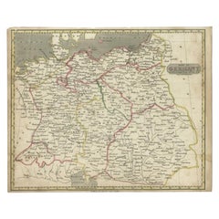
Antique Map of Germany by Walker, 1820
By R. Walker
Located in Langweer, NL
Antique map Germany titled 'Map of Germany as defined by the Peace of Paris'. Detailed antique map of Germany.
Artists and Engravers: Engrav...
Category
19th Century Antique R. Walker Maps
Materials
Paper
$62 Sale Price
20% Off
Related Items
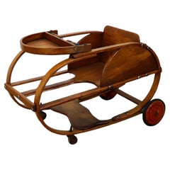
Antique Bauhaus Wooden Baby Walker
Located in Mexico City, CDMX
Circa 1940. We offer this rare Antique Bauhaus Wooden Baby Walker, great vintage conditions.
Category
1940s Mexican Bauhaus Vintage R. Walker Maps
Materials
Plywood
1864 Map of North America, Antique Hand-Colored Map, by Adolphe Hippolyte Dufour
Located in Colorado Springs, CO
Offered is a map of North America entitled Amerique du Nord from 1864. This rare, separately published wall map was produced by Adolphe Hippolyte Dufour. This map includes vibrant an...
Category
1860s French Antique R. Walker Maps
Materials
Paper
$4,500
H 44.5 in W 33 in D 1.5 in
Antique Andrees Handatlas, German Cartography Book, Maps, Atlas, Reference, 1924
Located in Hele, Devon, GB
This is a large volume antique copy of Andrees' Handatlas. A German, bound chromolithography atlas, dating to the early 20th century, this edition published in 1924.
Full title: And...
Category
1920s German Other Vintage R. Walker Maps
Materials
Paper
$866
H 17.72 in W 12.01 in D 2.56 in
1597 German Map of Alexandria by Georg Braun and Frans Hogenberg
By Georg Braun and Frans Hogenberg
Located in Chapel Hill, NC
1597 Map of Alexandria by Georg Braun and Frans Hogenberg, Germany. From "Civitas Orbis Terrarum", part 2, published in Cologne by Bertram Buchholz. Printed in 2 parts. Title: "Alexa...
Category
16th Century German Renaissance Antique R. Walker Maps
Materials
Paper
Antique Map of Principality of Monaco
By Antonio Vallardi Editore
Located in Alessandria, Piemonte
ST/619 - "Old Geographical Atlas of Italy - Topographic map of ex-Principality of Monaco" -
ediz Vallardi - Milano -
A somewhat special edition ---
Category
Late 19th Century Italian Other Antique R. Walker Maps
Materials
Paper
Antique Map of Italy by Andriveau-Goujon, 1843
By Andriveau-Goujon
Located in New York, NY
Antique Map of Italy by Andriveau-Goujon, 1843. Map of Italy in two parts by Andriveau-Goujon for the Library of Prince Carini at Palazzo Carini i...
Category
1840s French Antique R. Walker Maps
Materials
Linen, Paper
Antique Map Of Brabantia Ducantus By Bleau Circa 1640
Located in Brussels, Brussels
map of theBrabantia Ducantus (Belgium) circa 1640 by Bléau. Bléau was well known for antique atlas that he draw during the 17 century
beautiful map, double page folded in the middle,...
Category
17th Century French Renaissance Antique R. Walker Maps
Materials
Paper
Geographical Antique Map of Principality of Monaco
By Bruno Santini
Located in Alessandria, Piemonte
ST/609 - Interesting antique color map of Monaco Principality in French language : "Carte qui contient le Principauté de Piémont, le Monferrat et la comté de...
Category
Late 18th Century Italian Other Antique R. Walker Maps
Materials
Paper
Original Antique Map of Europe, Arrowsmith, 1820
Located in St Annes, Lancashire
Great map of Europe
Drawn under the direction of Arrowsmith.
Copper-plate engraving.
Published by Longman, Hurst, Rees, Orme and Brown, 1820
...
Category
1820s English Antique R. Walker Maps
Materials
Paper
Original Antique Map of South Africa, Arrowsmith, 1820
Located in St Annes, Lancashire
Great map of South Africa.
Drawn under the direction of Arrowsmith.
Copper-plate engraving.
Published by Longman, Hurst, Rees, Orme and Br...
Category
1820s English Antique R. Walker Maps
Materials
Paper
Original Antique English County Map, Durham, J & C Walker, 1851
Located in St Annes, Lancashire
Great map of Durham
Original colour
By J & C Walker
Published by Longman, Rees, Orme, Brown & Co. 1851
Unframed.
Category
1850s English Other Antique R. Walker Maps
Materials
Paper
Original 1891 Walker Map
Located in Norwell, MA
Original 1891 map of Massachusetts by Walker. Towns include Cambridge, Boston, Dedham, Ashland, Brookline, Newton etc... burl wood frame. Measures...
Category
19th Century Antique R. Walker Maps
R. Walker maps for sale on 1stDibs.
R. Walker maps are available for sale on 1stDibs. These distinctive items are frequently made of paper and are designed with extraordinary care. There are many options to choose from in our collection of R. Walker maps, although beige editions of this piece are particularly popular. If you’re looking for additional options, many customers also consider maps by Rand McNally & Co., Heinrich Kiepert, and J. Migeon. Prices for R. Walker maps can differ depending upon size, time period and other attributes — on 1stDibs, these items begin at $70 and can go as high as $70, while a piece like these, on average, fetch $70.


