Items Similar to Map Kyle Carrick Aireshire Thomas Kitchen 1749


Want more images or videos?
Request additional images or videos from the seller
1 of 5
Map Kyle Carrick Aireshire Thomas Kitchen 1749
About the Item
A Map of Kyle & Carrick Aireshire Thomas Kitchen 1749
In original black and gold frame
Just purchased more information to follow
MAKER Thomas Kitchin (1718-1784) English engraver and cartographer, who became hydrographer to the king.
- Creator:Thomas Kitchin (Artist)
- Dimensions:Height: 7.09 in (18 cm)Width: 7.88 in (20 cm)Depth: 0.79 in (2 cm)
- Style:Georgian (Of the Period)
- Materials and Techniques:
- Place of Origin:
- Period:
- Date of Manufacture:1749
- Condition:Wear consistent with age and use.
- Seller Location:BUNGAY, GB
- Reference Number:1stDibs: LU3867332633492
About the Seller
5.0
Vetted Seller
These experienced sellers undergo a comprehensive evaluation by our team of in-house experts.
Established in 1985
1stDibs seller since 2018
84 sales on 1stDibs
Typical response time: 9 hours
- ShippingRetrieving quote...Ships From: BUNGAY, United Kingdom
- Return PolicyA return for this item may be initiated within 7 days of delivery.
More From This SellerView All
- Map Southern Scotland Thomas Conder Alex Hogg 1795Located in BUNGAY, SUFFOLKA new map of the southern part of Scotland containing the counties of Stirling, Lanerk, Renfrew, Linlithgow, Edinburgh, Peebles, Haddingtoun, Berwick, Selkirk, Roxburgh, Dumfries, Wigtoun, Kirkudbright & Air Published by Alex Hogg at the Kings Arms...Category
Antique 18th Century English Georgian Maps
MaterialsPaper
- Map Turkey in Europe & Hungary Thomas Kitchin, 1783Located in BUNGAY, SUFFOLKThomas Kitchen (1718 - 1784) : Map of Turkey in Europe & Hungary 1783 Visible sheet within the cream mount 25.5cm., 10" height 20cm., 8" In an ebonised frame length 33cm. 13", height 28cm., 11" Kitchin, Thomas (1718 - 1784) Thomas Kitchin (August 4, 1718 – June 23, 1784) was a London based engraver, cartographer, and publisher. He was born in London to a hat-dyer of the same name. At 14, Kitchin apprenticed under Emanuel Bowen, under whom he mastered the art of engraving. He married Bowen daughter, Sarah Bowen, and later inherited much of his preceptor's prosperous business. Their son, Thomas Bowen Kitchin, also an engraver joined the family business, which thereafter published in Thomas Kitchin and Son. From 1858 or so Kitchin was the engraver to the Duke of York, and from about 1773 acquired the title, 'Royal Hydrographer to King George III.' He is responsible for numerous maps published in the The Star, Gentleman's Magazine, and London Magazine, as well as partnering with, at various times, with Thomas Jefferys, Emmanuel Bowen, Thomas Hinton, Issac Tayor, Andrew Dury, John Rocque, Louis de la Rochette, and Alexander Hogg, among others. Kitchin passed his business on to his son, Thomas Bowen Kitchin, who continued to republish many of his maps well after his death. Kitchin's apprentices included George Rollos...Category
Antique 18th Century English Georgian Maps
MaterialsPaper
- Map Bedfordshire General FramedLocated in BUNGAY, SUFFOLKA general map of Bedfordshire with its hundreds A scale of 5 miles in the original green mount and traditional black and gold frame. Measures: 36cm 14" high.Category
Antique 18th Century English Georgian Maps
MaterialsPaper
- Map Bedfordshire No 3 General FramedLocated in BUNGAY, SUFFOLKA general map of Bedfordshire with its hundreds. Measure: 37cm 14 1/2" high A scale of 5 miles. in the original green mount and traditional black and gold frame. charming map with...Category
Antique 18th Century English Georgian Maps
MaterialsPaper
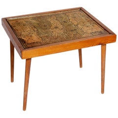
- Table Low Sofa Vintage 1950s Map Isle of Man John Speed 1610 Thomas Durham 1595Located in BUNGAY, SUFFOLK- The juxtaposition of modern design and this ancient map create a unique small table and conversation piece - This is the first map featuring the Isle of Man on its own. - It is also the first map of the Island based on an actual survey, undertaken by Thomas Durham 1595 and was first published by Speed in 1605-1611 and reprinted many times over the next century. This is the second state or print from 1610. The map is inset within a fruitwood box frame with a glass top. Supported by tapering stick legs. The map is based on a survey (and presumably a MS map) by Thomas Durham, of whom nothing is known other that he was paid by Sir Thomas Gerrard to make a survey of the Island. This survey, almost certainly for military purposes, arose from the disputed possession of the Island during which time Elizabeth had assumed control in order to prevent the Scots or the Spanish from using the Island as a base. Speed had used the Durham Map in his slightly earlier 4-sheet wall map showing invasions and battles of c1603/4 [ref: Shirley #261] - there are some differences from this 1605/10 map - Port Eran (rather than Earn on 1605);Knockalo point (= Contrary Hd) not on 1605;Spalbrecke shown west of Calf rather than E as on 1605/10. Thus it is possible that the Durham Map had even more detail than Speed used in his derived version. In sea are four mythical beasts with riders: to NW of Island Unicorn with Scottish flag...Category
Antique 1610s English Mid-Century Modern Sofa Tables
MaterialsPaper
- Map North Wales Robert Marsden AngleseyLocated in BUNGAY, SUFFOLKMap of North Wales by Robert Marsden Including Anglesey Charming topography and detail and colouring just purchased more information to follow.Category
Antique 18th Century English Georgian Maps
MaterialsPaper


You May Also Like
- Antique Map of Coiba Island by Anson '1749'Located in Langweer, NLAntique map titled 'Plan van de Oost-Zyde van het Eiland Quibo'. Original antique map of the eastside of Coiba Island (Quibo), Panama, showing the shoreline around Port de Dames indi...Category
Antique Mid-18th Century Maps
MaterialsPaper
- Antique Map of the Philippines by Anson '1749'Located in Langweer, NLAntique map titled 'Carte du Canal des Iles Philippines - Kaart van het Kanaal in de Filippynsche Eilanden'. Large detailed chart of the islands of the Philippines. One of the most detailed charts of the Philippines of the era. Shows Islands, bays, reefs, soundings tracks of the Manila Galleon route, etc. Includes a large compass...Category
Antique Mid-18th Century Maps
MaterialsPaper
- Antique Map of South America by G. Anson, 1749Located in Langweer, NLAntique map titled 'Kaart van het Zuidelykste Gedeelte van Zuider Amerika (..) - Carte de la Partie Meridionale de l'Amerique Meridionale (..)'. Detailed chart tracking the route of Capt. George Anson's ship The Centurion in 1745. The chart shows the tracks of Anson's ships around South America & Cape Horn to the Juan Fernandes Islands, with notes on currents and positions. This map originates from 'Reize rondsom de Werreld (..)' by George Anson, published 1749. In 1740 Capt. George Anson (1697-1762) of the Royal Navy, was given command of a squadron of ships. As England was at war with France and Spain, Anson's task was to intercept and capture a Spanish treasure...Category
Antique Mid-18th Century Dutch Maps
MaterialsPaper
- Uncoulored Original Antique Map of Western Africa, 1749Located in Langweer, NLInteresting detailed German antique map titled 'Neue Vorstellung der Abendlaendischen Küsten von Africa (..)'. Original antique map of Western Africa. This map originates from 'Neue ...Category
Antique Mid-18th Century Maps
MaterialsPaper
- Antique Map of Juan Fernandez Island by Anson '1749'Located in Langweer, NLAntique map titled 'l'Ile de Juan Fernandes dans la Mer du Sud (..) - Het Eiland Juan Fernandes in de Zuid Zee (..)'. This map depicts Juan Fernandez Island in the Southern Sea. This...Category
Antique Mid-18th Century Maps
MaterialsPaper
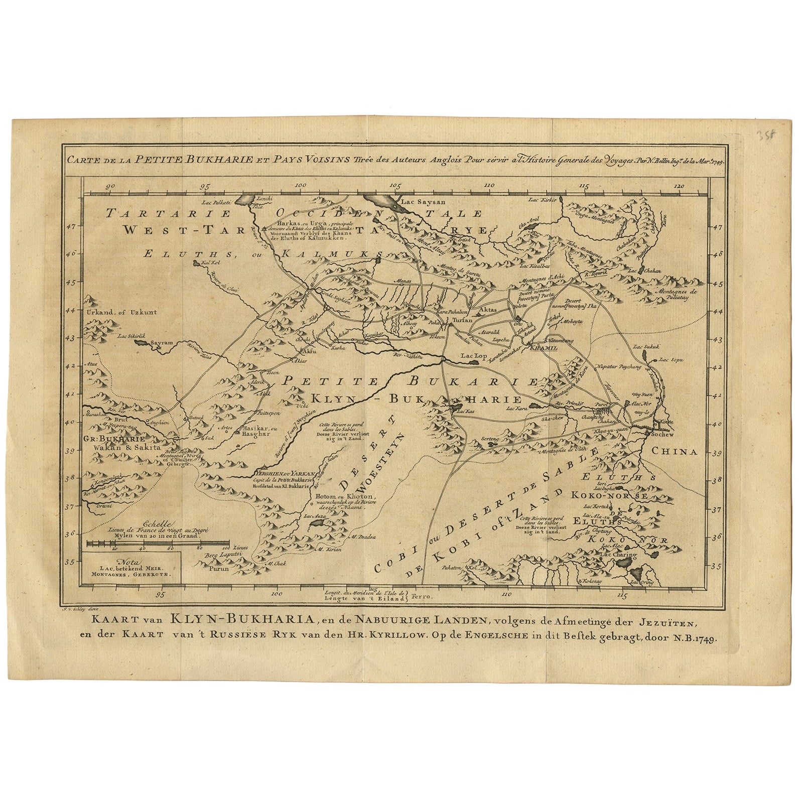
- Antique Map of Turkmenistan, Uzbekistan, Tajikistan and Kyrgyzstan, 1749Located in Langweer, NLAntique map titled ‘Carte de la Petite Bukharie et Pays Voisins – Tirée des Auteurs Anglois pour server a l ‘Histoire Generale des Voyages. Par N. Bellin Ing. D la Mar. 1749.’ Dutch title: ‘Kaart van Klyn-Bukharia, en de Nabuurige Landen, volgens de Afmeetinge der Jezuïten, en der Kaart van ’t Russiese Ryk van den Hr. Kyrillow. Op de Engelsche in dit Bestek gebragt door N.B. 1749’. An attractive mid-18th century French black and white map...Category
Antique 18th Century Maps
MaterialsPaper


