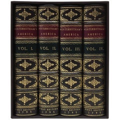
William Winterbotham's View of the American United States, First Editions, 1795
View Similar Items


Want more images or videos?
Request additional images or videos from the seller
1 of 6
William Winterbotham's View of the American United States, First Editions, 1795
$23,000List Priceper set
About the Item
- Dimensions:Height: 9.13 in (23.2 cm)Width: 5.88 in (14.94 cm)Depth: 7.5 in (19.05 cm)
- Sold As:Set of 4
- Materials and Techniques:
- Place of Origin:
- Period:1790-1799
- Date of Manufacture:1795
- Condition:Wear consistent with age and use.
- Seller Location:Colorado Springs, CO
- Reference Number:Seller: BK02481stDibs: LU90978273803
About the Seller
4.9
Platinum Seller
Premium sellers with a 4.7+ rating and 24-hour response times
Established in 2010
1stDibs seller since 2011
463 sales on 1stDibs
Authenticity Guarantee
In the unlikely event there’s an issue with an item’s authenticity, contact us within 1 year for a full refund. DetailsMoney-Back Guarantee
If your item is not as described, is damaged in transit, or does not arrive, contact us within 7 days for a full refund. Details24-Hour Cancellation
You have a 24-hour grace period in which to reconsider your purchase, with no questions asked.Vetted Professional Sellers
Our world-class sellers must adhere to strict standards for service and quality, maintaining the integrity of our listings.Price-Match Guarantee
If you find that a seller listed the same item for a lower price elsewhere, we’ll match it.Trusted Global Delivery
Our best-in-class carrier network provides specialized shipping options worldwide, including custom delivery.More From This Seller
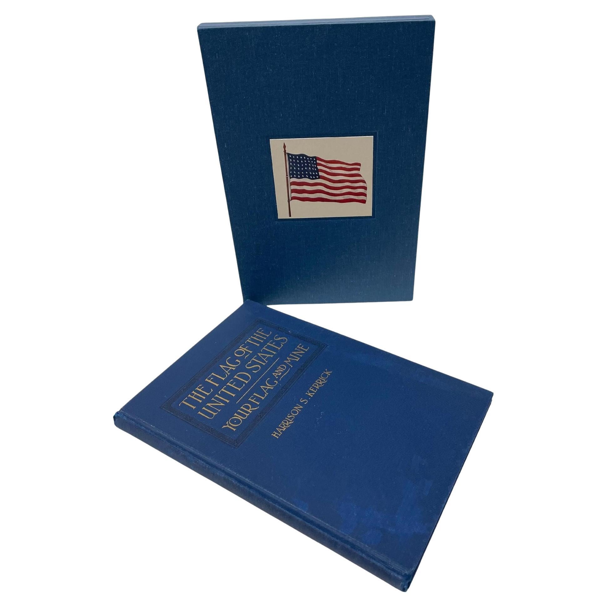
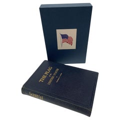
View AllThe Flag of the United States by Harrison S. Kerrick, First Edition, 1925
Located in Colorado Springs, CO
Kerrick, Harrison S. The Flag of the United States: Your Flag and Mine. Columbus: The Champlin Printing Co., 1925. First Edition, Second Printing. In original blue cloth boards, with gilt embossed title to the front board. New archival cloth slipcase.
Presented is a first edition, second printing of The Flag of the United States: Your Flag and Mine by Harrison S. Kerrick. This book was published by The Champlin Printing Co. in Columbus, Ohio. The first edition, first printing of this title was issued in February of 1925; this second printing was issued in April of 1925.
This book is a culmination of lifelong passion and respect for the American flag by the author Harrison S. Kerrick. The book begins by detailing the acts of continental and national Congresses, presidential proclamations, and Executive Orders that established the United States flag and Great Seal. He discusses the state laws pertaining to the American flag and argues the importance of a national flag code. Kerrick delves into the past history of flag design, including which European flags were popular in the early colonies, the early banners of the colonies, and the design elements that make up the stars and stripes as we know it today. He spends two chapters covering the facts and fictional myths surrounding our national flag. He then details how best to use the flag for personal and public use, inclduding how to create a flag, care for a flag, and the codes of conduct surrounding the proper display of the flag.
Lieutenant colonel Harrison Summers Kerrick (1873 – 1939) was an United States Army officer, teacher, and author. Kerrick was born in 1873 in Bloomington, Illinois, and attended Illinois Wesleyan University. In 1898, he enlisted in Company C of the 2nd Illinois Volunteer Infantry, serving in the Spanish–American War, during which he was promoted to captain. He served as a field artillery officer in the Philippine–American War and in WWI, he served in the U.S. Army Coast Artillery Corps from December 1917 to February 1918.
A lecturer and teacher, Kerrick was also the author of two books, Military and Naval America and The Flag of the United States. Passionate about American history and the symbolism of the American flag, Kerrick created the code of conduct on the proper handling and display of the United States flag, which was later adopted by the United States Congress...
Category
Vintage 1920s American Arts and Crafts Books
Materials
Paper

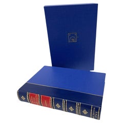
The Flag of the United States by Milo Milton Quaife, First Edition, 1942
Located in Colorado Springs, CO
Quaife, Milo Milton. The Flag of the United States. New York: Grosset & Dunlap, 1942. First edition. Octavo. Rebound in ¼ leather and cloth boards, with raised bands and gilt embossed titles to the spine. Illustrated. Presented with a matching archival slipcase.
Presented is a first edition printing of The Flag of the United States by Milo Milton Quaife. The book was published in New York by Grosset & Dunlap in 1942. It is presented here rebound in ¼ leather and cloth boards, with raised bands and gilt titles to the spine, and a matching archival slipcase.
Quaife wrote The Flag of the United States in order to present “the true and authentic history of the United States.” Wading through the myths and stories surrounding the flag, he details the origins and evolution of the American flag, using careful research to determine fact from fiction. There are several chapters on the early flags of Spain, France, and Holland in America and Quaife traces the development of the American flag from its English predecessor. He articulates the twenty-nine word resolution of the Second Continental Congress that made the flag of the United States, then outlines the changes to the flag’s design made in 1795, 1818, and 1912. He has a chapter on Civil War flags, a chapter on flags of the Army, and several debunking the many myths surrounding the American flag.
This book was very well received upon its publication. “Quaife is entitled to a good deal of praise for having written a straightforward, and very readable, history of our flag” (Ralph W. Steen, Southwestern Historical Quarterly, 1943). “To read this history of our flag is to read the history of these United States, not only in the years when we became an infant nation, but also in those later years variously devoted to territorial expansion, extending our commerce, and fighting other wars.” (Ardelia Olden Koch, Wisconsin Magazine of History, 1943).
Milo Milton Quaife (1880–1959) was a historian and writer, born in Nashua, Iowa. He received his education at Grinnell College, the University of Missouri, and the University of Chicago. Quaife was a published historian of the Great Lakes region, the Mississippi River valley, the Gold Rush, and President Polk...
Category
Vintage 1940s American Mid-Century Modern Books
Materials
Leather, Paper
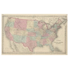
1859 "Map of the United States of America..." by J. H. Colton
By J.H. Colton
Located in Colorado Springs, CO
Presented is an 1859 “Map of the United States of America, the British Provinces, Mexico, the West Indies and Central America with Part of...
Category
Antique 1850s American Maps
Materials
Paper

N.E. View of the United States Capitol, Washington, DC Antique Proof Print 1858
Located in Colorado Springs, CO
This engraved print shows a view of the United States Capitol Building, in Washington, D.C. The print depicts the neoclassical building from the northeast orientation, with a bustling street scene in front. The steel engraving is a proof printing, drawn and engraved by Henry Sartain and published in 1858.
Plans began in May 1854 to build a new cast-iron dome for the United States Capitol. The then-architect of the Capitol Thomas Walter and his team were sold on the aesthetics of a new dome, as well as the utility of a fire-proof one. A year later, on March 3, 1855, President Franklin Pierce...
Category
Antique 1850s American Prints
Materials
Paper

The Flag of the United States by Hon. Frederick C. Hicks, Third Edition, 1926
Located in Colorado Springs, CO
Hicks, Frederick C. The Flag of the United States. Washington: W. F. Roberts Company, 1926. Third Edition. Octavo. Illustrated. In original leatherette boards with gilt titles to the...
Category
Vintage 1920s American Arts and Crafts Books
Materials
Fabric, Paper
1866 Ensign & Bridgman's Rail Road Map of the United States
Located in Colorado Springs, CO
Presented is an 1866 issue of “Ensign & Bridgeman’s Rail Road Map of the United States, showing Depots & Stations.” First published in 1856, this is the third edition, following anot...
Category
Antique 1860s American Late Victorian Maps
Materials
Paper

You May Also Like
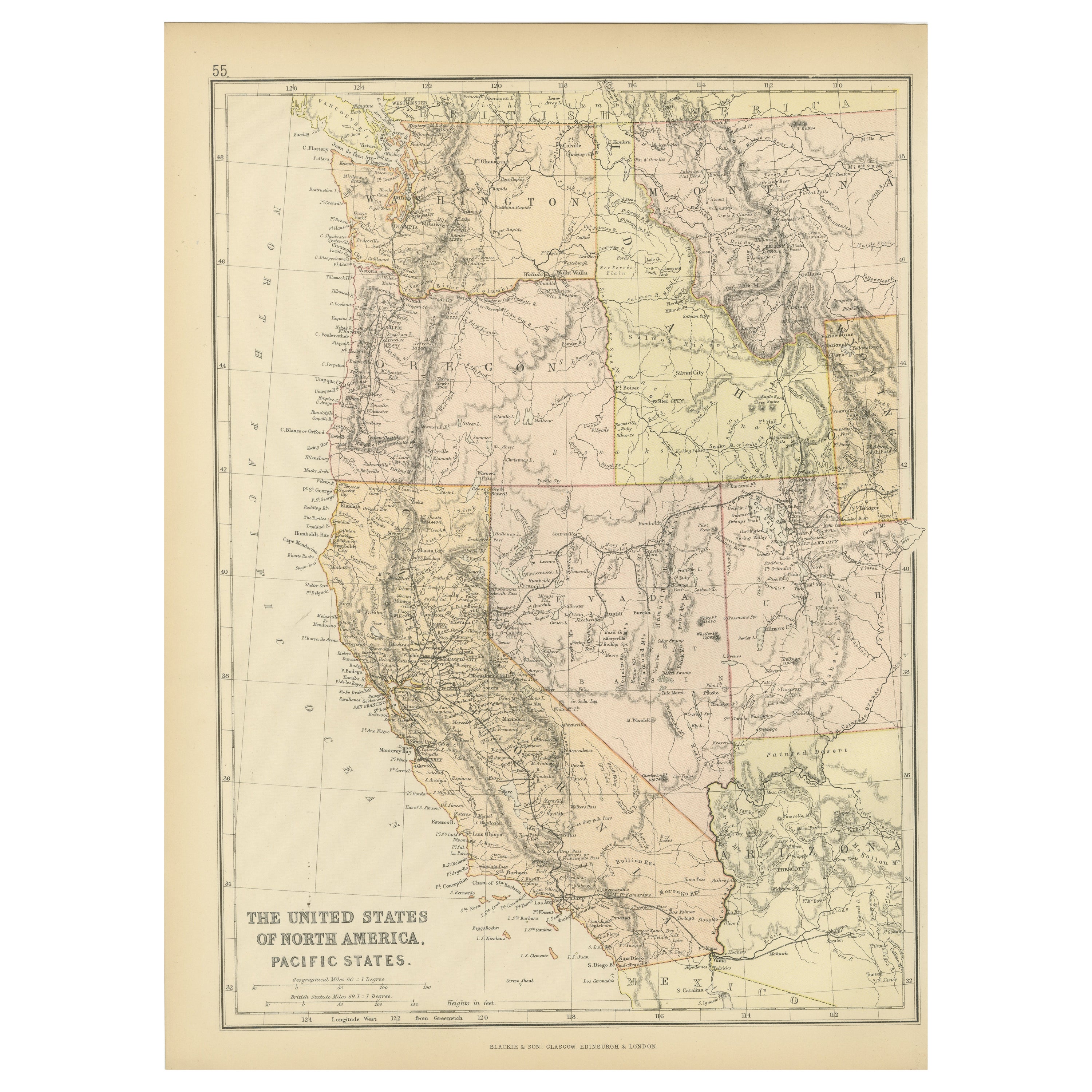
Antique Map of The United States of North America, Pacific States, 1882
Located in Langweer, NL
The map is from the same 1882 Blackie Atlas and focuses on the Pacific States of the United States of America during that period. Here are some details and historical context about t...
Category
Antique 1880s Maps
Materials
Paper

$238 Sale Price
20% Off
Free Shipping
Antique Map of the United States of North America, c.1882
Located in Langweer, NL
Antique map titled 'United States of North America'. Old map of the United States of North America. This map originates from 'The Royal Atlas of Modern Geography, Exhibiting, in a Se...
Category
Antique 1880s Maps
Materials
Paper

$334 Sale Price
20% Off
Antique Map of The United States of North America, 1882
Located in Langweer, NL
This is a historical map titled "The United States of North America, Central Part" from the 1882 Blackie Atlas. It depicts the continental United States with a high level of detail, ...
Category
Antique 1880s Maps
Materials
Paper

Antique Map Colton's United States of America
Located in Langweer, NL
Antique map titled 'Colton's United States of America'. Show railroads, canals, state capitals, major cities and towns, military posts, historic trails, Pony Express and U.S. mail routes; Dakota [Territory] extending deep into Nebraska, and Idaho [Territory] encompassing [modern day] Montana and Wyoming; Indian Territory...
Category
Antique Mid-19th Century Maps
Materials
Paper
$850 Sale Price
20% Off
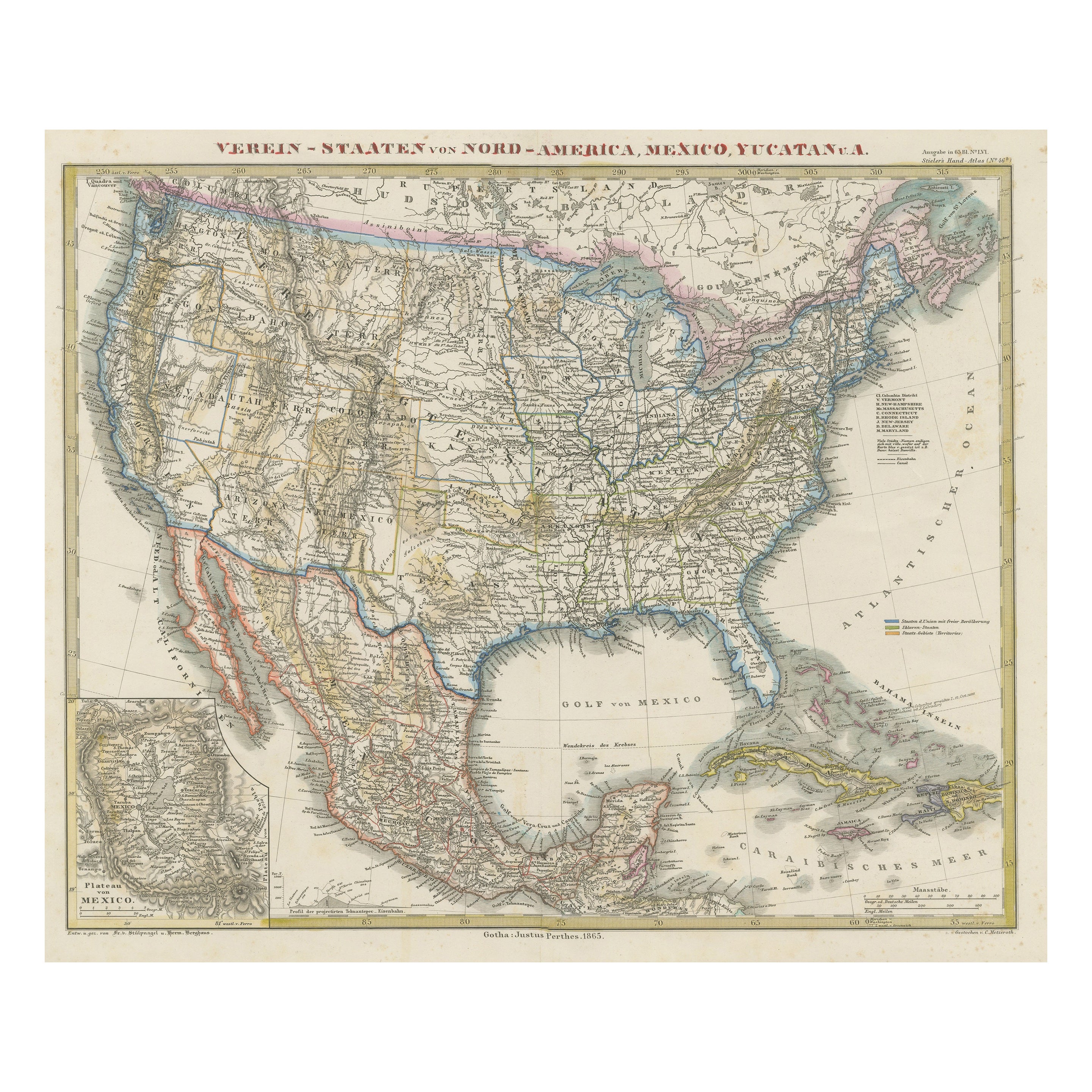
Antique Map of the United States of America, also showing the Caribbean
Located in Langweer, NL
Antique map titled 'Verein-Staaten von Nord-America, Mexico, Yucatan u.a.'. Very detailed map of the United States of America showing the ...
Category
Antique Mid-19th Century Maps
Materials
Paper

$783 Sale Price
20% Off
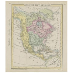
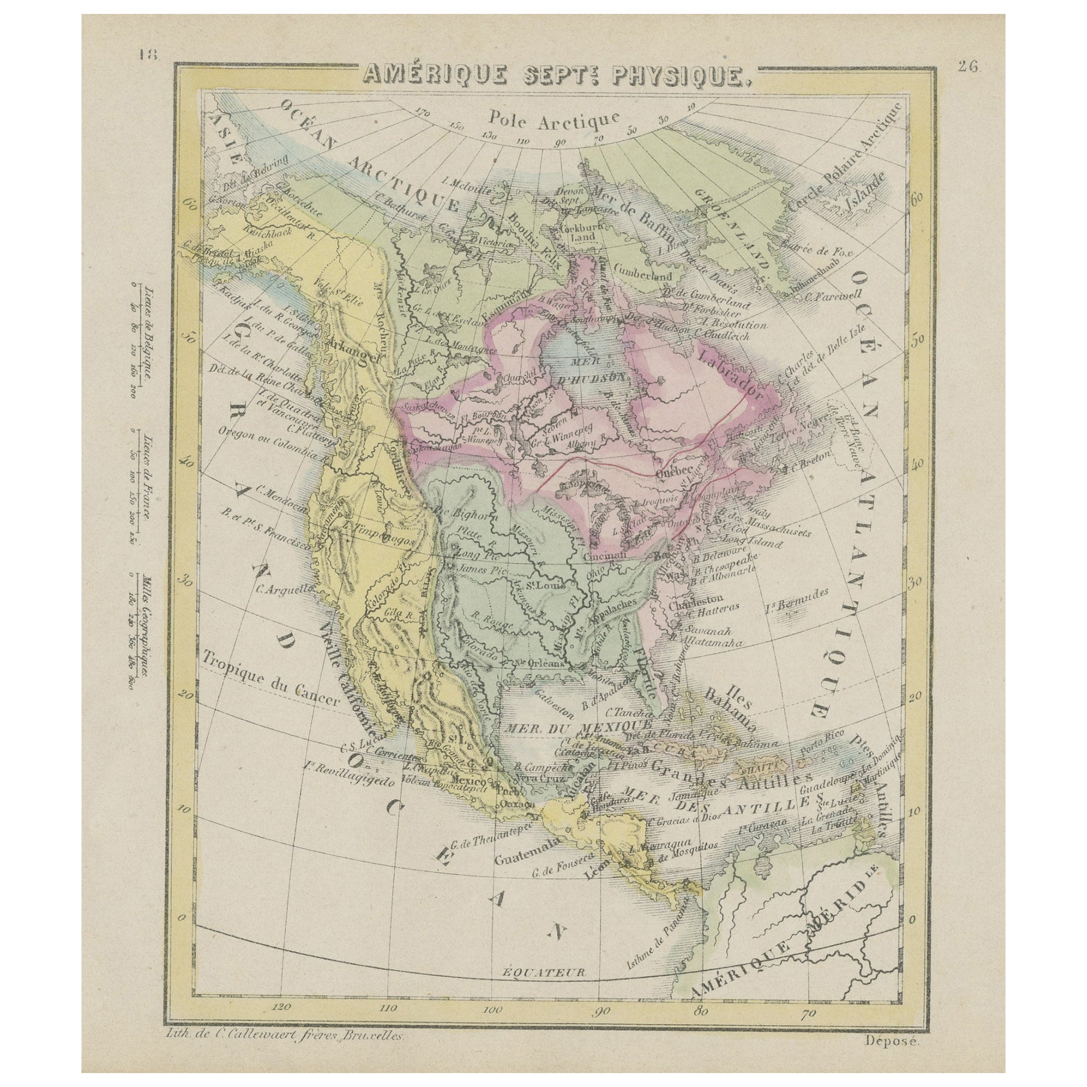
Small Map of the United States, circa 1870
Located in Langweer, NL
Antique map titled 'Amérique septe. Physique'. Small map of the United States. lithographed by C. Callewaert brothers in Brussels circa 1870.
Category
Antique Mid-19th Century Belgian Maps
Materials
Paper