Items Similar to 1616 Petrus Bertius Miniature Map of Cambay (Gujarat, India)


Want more images or videos?
Request additional images or videos from the seller
1 of 10
1616 Petrus Bertius Miniature Map of Cambay (Gujarat, India)
$419.35
£312.18
€350
CA$574.41
A$638.86
CHF 333.59
MX$7,774.29
NOK 4,260.51
SEK 3,995.61
DKK 2,664.43
Shipping
Retrieving quote...The 1stDibs Promise:
Authenticity Guarantee,
Money-Back Guarantee,
24-Hour Cancellation
About the Item
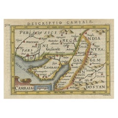
Title: 1616 Petrus Bertius Map of Cambay and Gujarat, India
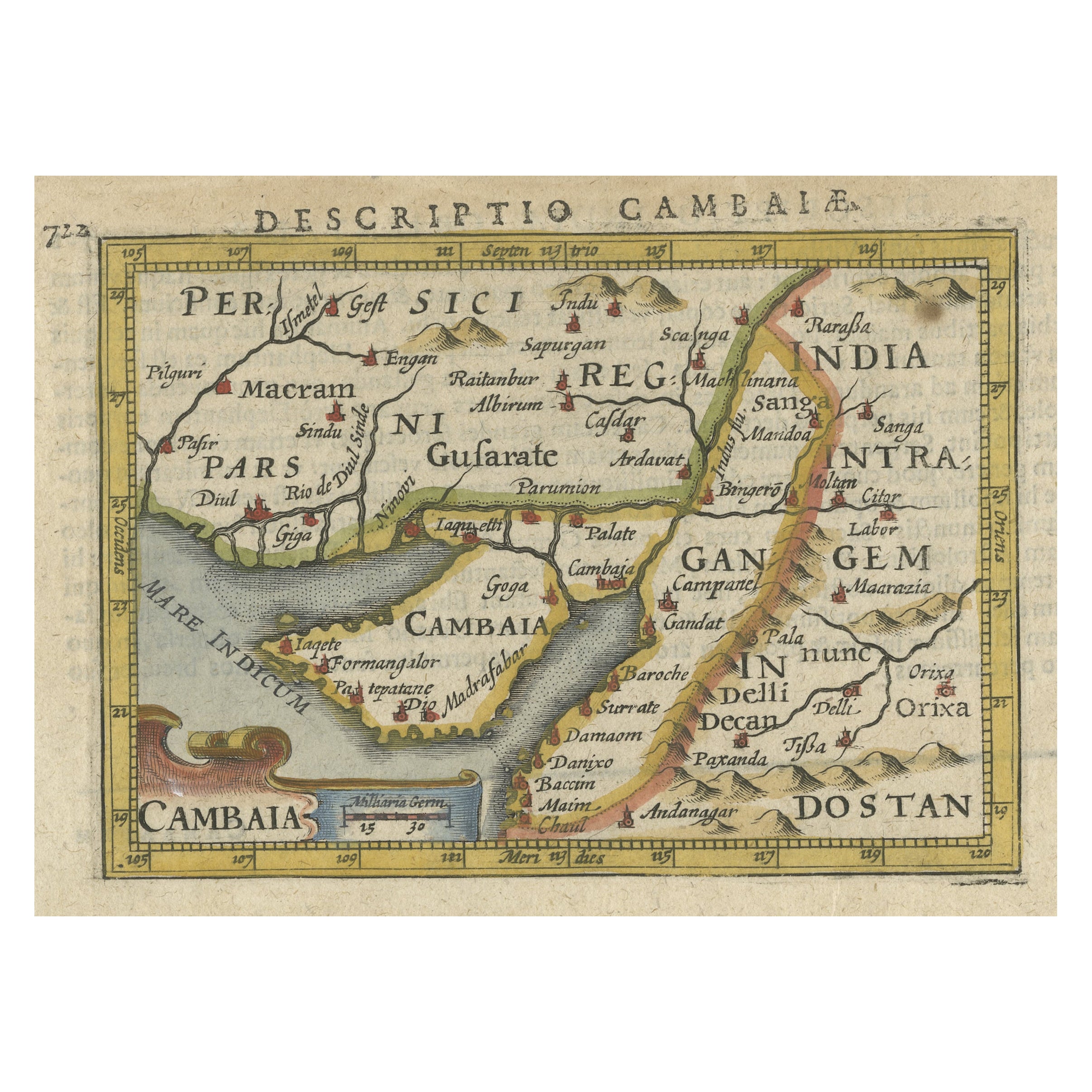
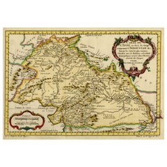
Description: This early seventeenth-century map, titled Descriptio Cambaiæ, was published in 1616 by Petrus Bertius, a well-known Dutch cartographer and historian. It depicts Cambay, known today as Khambhat, along with the surrounding regions of Gujarat, India, and parts of Rajasthan and Maharashtra. The map was originally based on Barent Langenes' Caert-Thresoor, first published between 1598 and 1600, and was later included in Bertius' 1616 edition of Tabularum Geographicarum Contractarum, a widely circulated geographic atlas of the time.
This map provides a detailed view of northwestern India, highlighting significant trade centers, rivers, and coastal ports along the Mare Indicum, or Indian Ocean. The region of Cambay was an important commercial hub during the Mughal period, known for its textile production and extensive maritime trade. The decorative cartouche in the lower-left corner bears the title “Cambaia,” emphasizing the city's significance as a major trading center connecting India with the Middle East and Europe.
The map includes various political and geographical details. It marks Pars, which corresponds to the Sindh region in modern-day Pakistan, featuring locations such as Diul, or Diu, Pafpr, or Porbandar, and Giga. The region of Gujsarate, or Gujarat, includes cities like Cambaya, or Khambhat, Goga, or Gogha, and Madrafabar, or Madrafapur. Further inland, the map identifies Delli, or Delhi, and Decan, or the Deccan Plateau, representing the heart of the Mughal Empire. The map also notes Gangem, referring to the Ganges region, highlighting trade connections between western and eastern India. The Gulf of Cambay is prominently depicted with key trading ports such as Damaom, or Daman, and Bacim, or Bassein, which were part of Portuguese-controlled India during the early seventeenth century.
Hand-colored details add a vibrant touch, with different regions shaded in yellow, green, and red to distinguish territorial divisions. Small red icons representing fortified cities and ports reflect the strategic importance of various locations in regional and global trade.
Cartographer and Source:
Petrus Bertius, who lived from fifteen sixty-five to sixteen twenty-nine, was a Dutch cartographer, historian, and theologian. His 1616 edition of Tabularum Geographicarum Contractarum compiled and reissued maps originally created by Barent Langenes and Jodocus Hondius. Bertius’ work was designed for scholars, traders, and explorers, providing a compact but highly detailed view of the known world during the early seventeenth century. His maps became an essential reference for European maritime powers seeking trade opportunities in India and Asia.
Condition Report:
The paper is well-preserved, showing the fine laid texture typical of early seventeenth-century Dutch printing. The engraving remains sharp, with clearly legible place names and delicate line work defining rivers, coastlines, and settlements.
There is slight age-toning, especially along the edges, which is expected in a map of this period. Minor text bleed-through from the reverse is present but does not interfere with the visual clarity of the map. The original hand-coloring remains vibrant, with only minimal fading. The margins are intact, and there are no significant tears, stains, or restorations, making this a well-preserved and highly collectible example of an early European map of India.
Framing Recommendations:
To properly protect and display this antique map, archival-quality materials are recommended.
For matting and backing, use acid-free, museum-grade board to prevent deterioration. A double mat with a neutral outer mat and a subtle gold or beige inner accent will highlight the fine details and warm tones of the engraving.
A dark walnut, black, or gilded wooden frame will complement the historical character of the map. An antique-style frame with subtle carvings can enhance its early seventeenth-century aesthetic.
To ensure longevity, UV-resistant museum glass or acrylic is advised to prevent fading from light exposure. Anti-reflective glass will allow clear visibility of the intricate details without glare.
For mounting, avoid adhesives that could damage the paper. Instead, use archival-quality corner mounts or Japanese paper hinges to secure the map without causing harm.
The framed map should be displayed in a stable environment, away from direct sunlight, humidity, and extreme temperature fluctuations. A study, library, or gallery setting would be ideal for appreciating its historical and artistic value.
This 1616 Bertius map of Cambay and Gujarat is a rare and historically significant artifact, reflecting early European exploration, trade, and cartographic representation of India. It is a valuable addition to collections focused on antique maps, Indian maritime history, and early cartography of South Asia.
- Dimensions:Height: 4.85 in (12.3 cm)Width: 7.37 in (18.7 cm)Depth: 0.01 in (0.2 mm)
- Materials and Techniques:Paper,Engraved
- Period:1610-1619
- Date of Manufacture:1616
- Condition:Good condition. Light age-toning, particularly along the edges. The original hand-coloring is well preserved, with only slight fading in some areas. The margins remain intact, with minor text bleed-through from the reverse.
- Seller Location:Langweer, NL
- Reference Number:Seller: BGSH-0081stDibs: LU3054343931262
About the Seller
5.0
Recognized Seller
These prestigious sellers are industry leaders and represent the highest echelon for item quality and design.
Platinum Seller
Premium sellers with a 4.7+ rating and 24-hour response times
Established in 2009
1stDibs seller since 2017
2,510 sales on 1stDibs
Typical response time: <1 hour
- ShippingRetrieving quote...Shipping from: Langweer, Netherlands
- Return Policy
Authenticity Guarantee
In the unlikely event there’s an issue with an item’s authenticity, contact us within 1 year for a full refund. DetailsMoney-Back Guarantee
If your item is not as described, is damaged in transit, or does not arrive, contact us within 7 days for a full refund. Details24-Hour Cancellation
You have a 24-hour grace period in which to reconsider your purchase, with no questions asked.Vetted Professional Sellers
Our world-class sellers must adhere to strict standards for service and quality, maintaining the integrity of our listings.Price-Match Guarantee
If you find that a seller listed the same item for a lower price elsewhere, we’ll match it.Trusted Global Delivery
Our best-in-class carrier network provides specialized shipping options worldwide, including custom delivery.More From This Seller
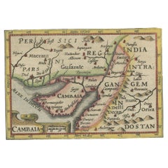
View AllRare Antique Miniature Map of Pakistan, India and Cambaia, ca.1616
Located in Langweer, NL
Old 17th century miniature antique map of 'Cambaia' , from the 1616 edition of Jadocus Hondius Atlas by Petrus Bertius.
Original copperplate engraving with hand coloring.
Carto...
Category
Antique 17th Century Maps
Materials
Paper
$373 Sale Price
20% Off
Rare Antique Miniature Map of Pakistan, India and Cambaia, ca.1618
Located in Langweer, NL
Old 17th century miniature antique map of 'Cambaia' , from the 1616 edition of Jadocus Hondius Atlas by Petrus Bertius.
Original copperplate engraving with hand coloring.
Carto...
Category
Antique 17th Century Maps
Materials
Paper
$373 Sale Price
20% Off
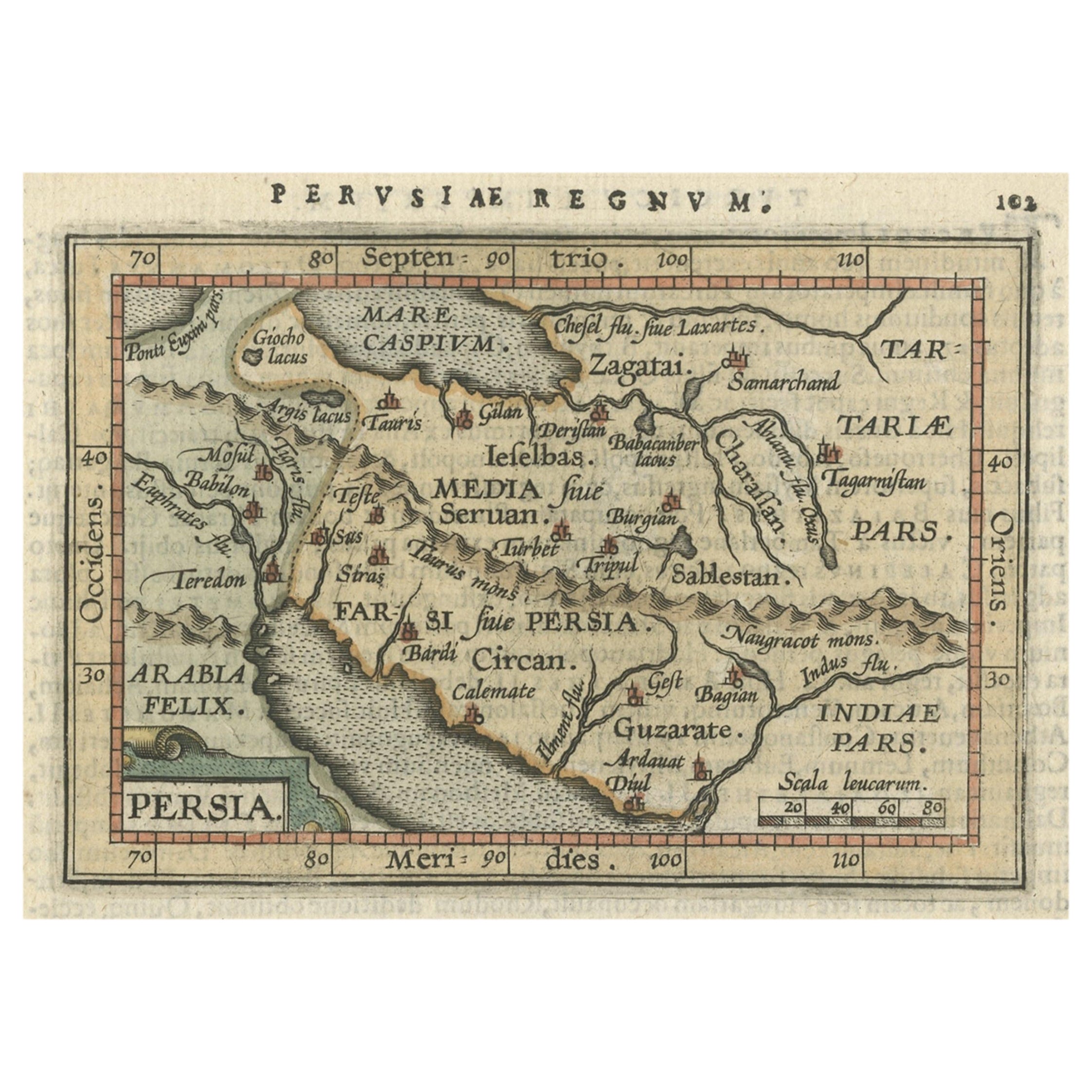
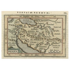
Original Antique Miniature Map of Persia, Published, ca.1601
Located in Langweer, NL
Antique miniature map titled 'Persia'. Small map of Persia published in the Epitome, or pocket-edition of the "Theatrum Orbis Terrarum".
Artists and e...
Category
Antique Early 1600s Maps
Materials
Paper
$517 Sale Price
20% Off
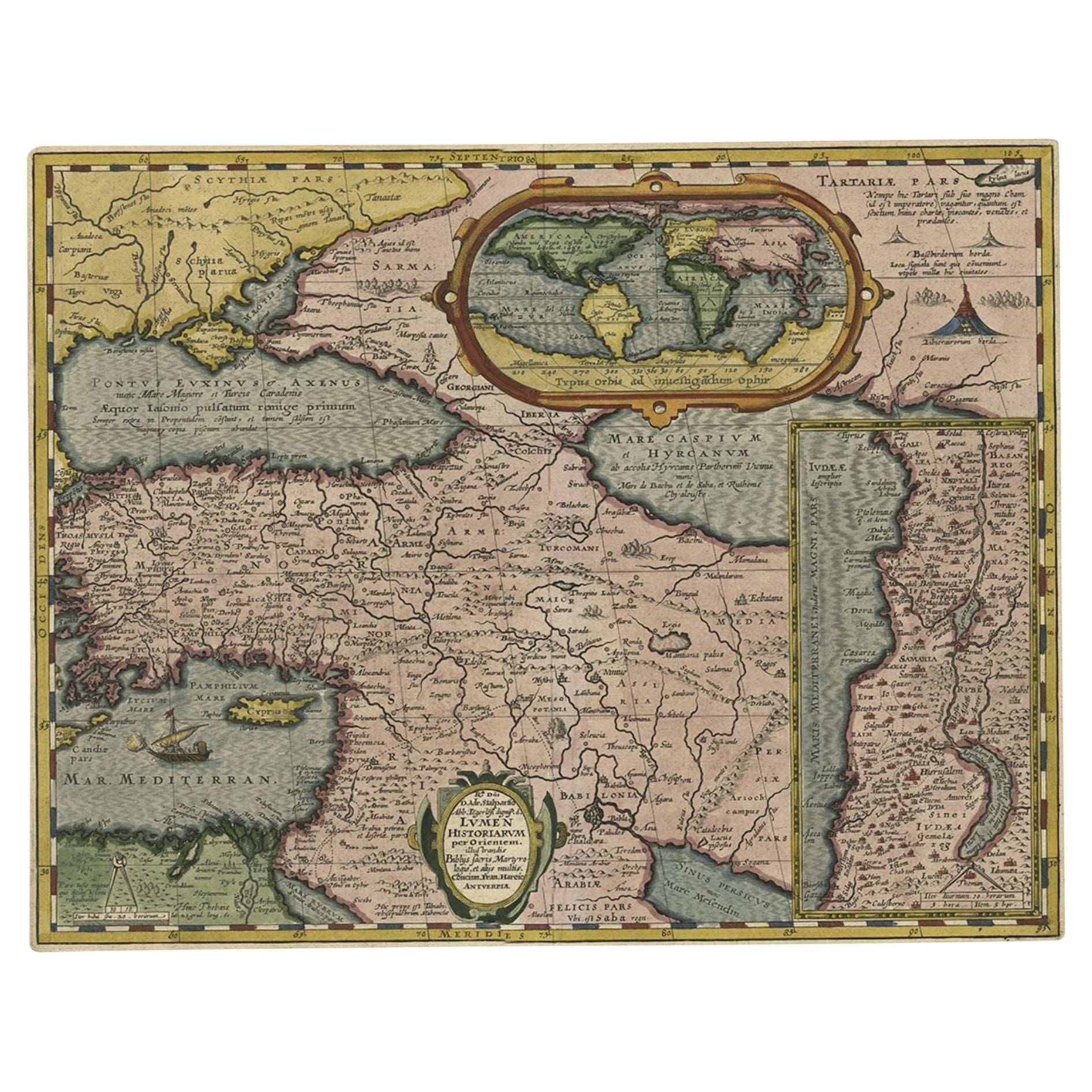
Scarce Antique Map of the Middle East, Surrounded by Latin Text, 1624
Located in Langweer, NL
Antique map titled 'Lumen Historium per Orientem (..).'
Scarce map of the Middle East, surrounded by Latin text. The two insets show Israel and an oval world map. This map (from the last edition of Ortelius Theatri Orbis Terrarum Parergon, 1624) was engraved by Franciscus Hareio. Later, this map was copied by Hornius for his World Atlas (1653).
Artists and Engravers: Franciscus Haraeus (Latinised form of Franciscus Verhaer; also known as Frans Verhaer), (Utrecht 1555? - Leuven, 11 January 1631), was a Dutch theologian, historian, and cartographer. He is best known for his history (from a Catholic point of view) of the Dutch Revolt...
Category
Antique 1620s Maps
Materials
Paper

$910 Sale Price
20% Off
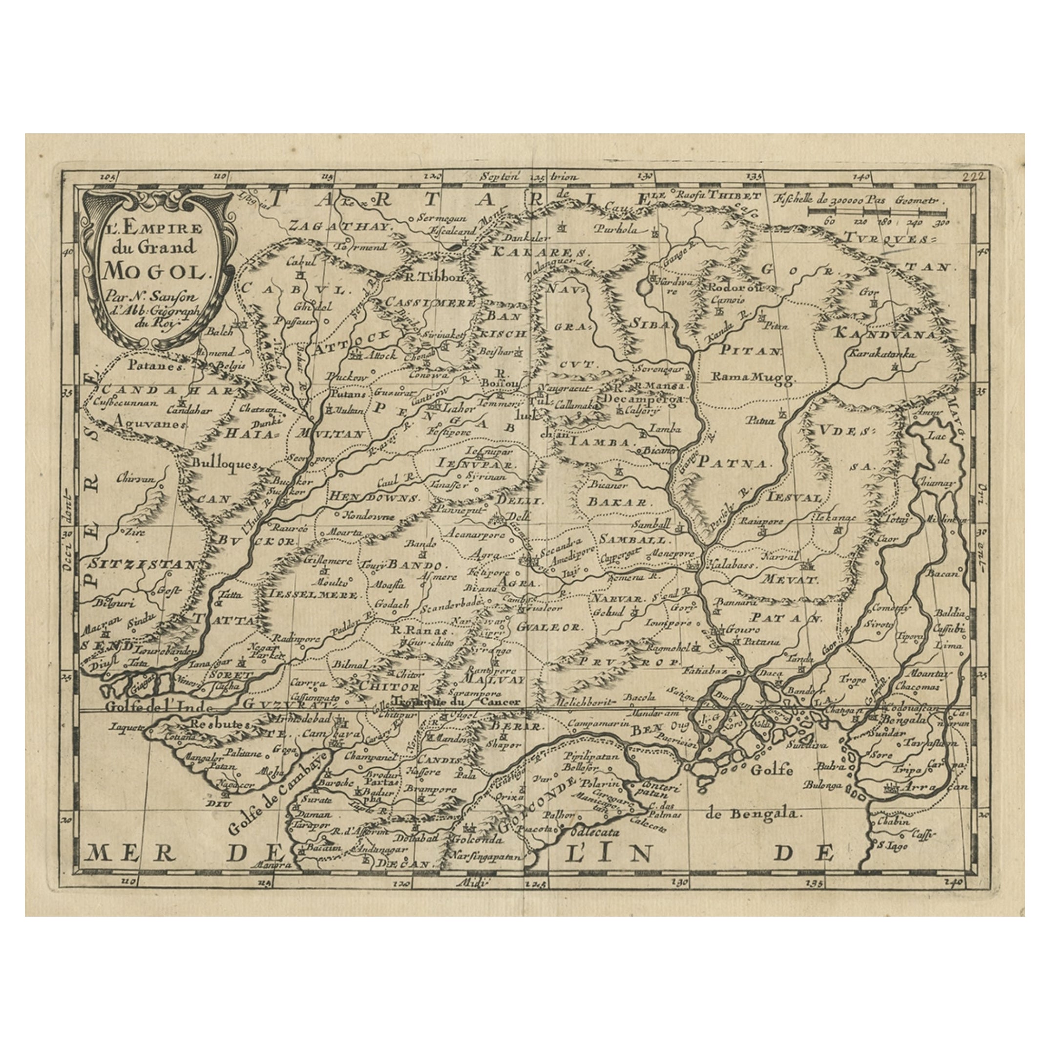
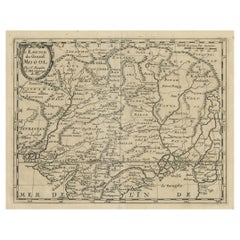
Old Map of the Mughal Empire, Persia in the West to Lake Chimay etc., ca.1685
Located in Langweer, NL
Antique map titled 'L'Empire du Grand Mogol'. Old map of India and Central Asia.
The map extends from Persia in the West to Lake Chimay and the Bay of Bengal...
Category
Antique 1680s Maps
Materials
Paper
$306 Sale Price
20% Off
Nicely Hand-Colored Antique Map of Part of India, the Ganges & Hindustan, 1755
Located in Langweer, NL
Antique map titled 'Carte de l'Inde en deca du Gange comprenant l' Indoustan (..)'
A map of part of India, the Ganges and Hindustan. From: Antoine Francois Prevost d'Exiles' (or ...
Category
Antique 1750s Maps
Materials
Paper
$613 Sale Price
20% Off
You May Also Like
"Nova Barbariae Descriptio", a 17th Century Hand-Colored Map of North Africa
By Johannes Janssonius
Located in Alamo, CA
This original attractive 17th century hand-colored map of North Africa entitled "Nova Barbariae Descriptio" by Johannes Janssonius was published in Paris in 1635. It includes the Med...
Category
Antique Mid-17th Century Dutch Maps
Materials
Paper

Engraving Depicting 16th Century Map of Terra Sancta
Located in Buchanan, MI
Abraham Ortelius (Flemish, 1527-1598) Terra Sancta.
Engraving depicting 16th century map of Terra Sancta. Site 15" x 19.5.
Category
Antique 18th Century and Earlier Maps
Materials
Paper

1590 Mercator Map Entitled "France Picardie Champaigne, Ric.0001
Located in Norton, MA
Description: Published in Amsterdam by Mercator/Hondius ca. 1590.
Ric.0001
Artists and Engravers: Map : 'France Picardie Champaigne cum regionibus adiacentibus'. (Map of the french provinces of Picardie and Champagne.) Copper engraved map of the french provinces of Picardie and Champagne, showing the cities of Caen, Paris, Melun, Auxerre, Verdun, etc. Copperplate engraving on verge type hand laid paper with watermark. Description: Published in Amsterdam by Mercator/Hondius ca. 1600.Artists and Engravers: Mercator was born in Rupelmonde in Flanders and studied in Louvain under Gemma Frisius, Dutch writer, astronomer and mathematician. The excellence of his work brought him the patronage of Charles V, but in spite of his favor with the Emperor he was caught up in the persecution of Lutheran protestants and charged with heresy, fortunately without serious consequences. No doubt the fear of further persecution influenced his move in 1552 to Duisburg, where he continued the production of maps, globes and instruments. Mercator's sons and grandsons, were all cartographers and made their contributions in various ways to his atlas. Rumold, in particular, was responsible for the complete edition in 1595. The map plates...
Category
Antique 16th Century Dutch Maps
Materials
Paper

Persia, Armenia & Adjacent Regions: A 17th Century Hand-colored Map by De Wit
By Frederick de Wit
Located in Alamo, CA
A large 17th century hand colored copperplate engraved map entitled "Novissima nec non Perfectissima Scandinaviae Tabula comprehendens Regnorum Sueciae, Daniae et Norvegiae distincte...
Category
Antique Late 17th Century Dutch Maps
Materials
Paper

1633 Map Entitled "Beauvaisis Comitatus Belova Cium, Ric.0002
Located in Norton, MA
1633 map entitled
"Beauvaisis Comitatus Belova Cium,"
Hand Colored
Ric.0002
Description: Cartographer : - Hondius, Henricus 1587-1638
Artists and Engravers:Jodocus Hondius, one of the most notable engravers of his time. He is known for his work in association with many of the cartographers and publishers prominent at the end of the sixteenth and the beginning of the seventeenth century. A native of Flanders, he grew up in Ghent, apprenticed as an instrument and globe maker and map engraver. In 1584, to escape the religious troubles sweeping the Low Countries at that time, he fled to London where he spent some years before finally settling in Amsterdam about 1593. In the London period he came into contact with the leading scientists and geographers of the day and engraved maps in The Mariner\\\\\\\\\\\\\\\'s Mirrour, the English edition of Waghenaer\\\\\\\\\\\\\\\'s Sea Atlas, as well as others with Pieter van den Keere, his brother-in-law. No doubt his temporary exile in London stood him in good stead, earning him an international reputation, for it could have been no accident that Speed chose Hondius to engrave the plates for the maps in The Theatre of the Empire of Great Britaine in the years between 1605 and 1610. In 1604 Hondius bought the plates of Mercator\\\\\\\\\\\\\\\'s Atlas which, in spite of its excellence, had not competed successfully with the continuing demand for the Ortelius Theatrum Orbis Terrarum. To meet this competition Hondius added about 40 maps to Mercator\\\\\\\\\\\\\\\'s original number and from 1606 published enlarged editions in many languages, still under Mercator\\\\\\\\\\\\\\\'s name but with his own name as publisher. These atlases have become known as the Mercator/Hondius series. The following year the maps were reengraved in miniature form and issued as a pocket Atlas Minor. After the death of Jodocus Hondius the Elder in 1612, work on the two atlases, folio and miniature, was carried on by his widow and sons, Jodocus II and Henricus, and eventually in conjunction with Jan Jansson in Amsterdam.
In all, from 1606 onwards, nearly 50 editions with increasing numbers of maps with texts in the main European languages were printed. Summaries of these issues are given under the entry for Gerard Mercator. Jodocus Hondius the Elder * 1588 Maps in The Mariner\\\\\\\\\\\\\\\'s Mirrour (Waghenaer/Ashley) * 1590 World Map...
Category
Antique 17th Century Dutch Maps
Materials
Paper

West Africa: A 17th Century Hand-Colored Map by Mercator/Hondius
By Gerard Mercator
Located in Alamo, CA
A 17th century hand-colored map entitled "Guineae Nova Descriptio" by Gerard Mercator and Jodocus Hondius, published in their 'Atlas Minor' in Amsterdam in 1635. It is focused on the...
Category
1630s Landscape Prints
Materials
Engraving

More Ways To Browse
India Engraving
Antique Key Heart
Mughal Frame
Mughal Textiles
Japanese Compact
Stained Glass Dutch
India Miniature
Antique Rajasthan
Rajasthan Antique Furniture
Live Edge Black Walnut
Mughal Miniature
Antique Furniture Delhi
Indian Reverse Glass
Mughal Antique Glasses
Vintage Scandanavian Chairs
19th Century Red Glass
Antique French Console Table Tables
Silver Bowl Large