Items Similar to 1683 Alain Manesson Mallet Map of Ancient India, the Ganges, and Taprobane


Want more images or videos?
Request additional images or videos from the seller
1 of 10
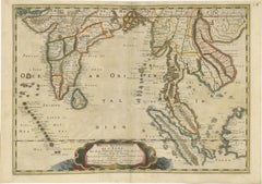
1683 Alain Manesson Mallet Map of Ancient India, the Ganges, and Taprobane
$535.03
$668.7920% Off
£395.36
£494.1920% Off
€448
€56020% Off
CA$741.17
CA$926.4620% Off
A$810.13
A$1,012.6620% Off
CHF 426.67
CHF 533.3420% Off
MX$9,961.30
MX$12,451.6320% Off
NOK 5,332.26
NOK 6,665.3220% Off
SEK 5,016.60
SEK 6,270.7520% Off
DKK 3,411.49
DKK 4,264.3620% Off
About the Item
Title: 1683 Alain Manesson Mallet Map of Ancient India, the Ganges, and Taprobane
Description: This finely engraved seventeenth-century map, titled Inde Ancienne à l’Occident du Gange, was published in 1683 as part of Alain Manesson Mallet’s 'Description de l’Univers'. The map was produced in Paris by Denys Thierry and is hand-colored, presenting an early European interpretation of ancient India, the Indian Ocean, and the surrounding territories, including Taprobane, an early cartographic representation of Sri Lanka.
Mallet’s map focuses on India as it was understood in classical antiquity, drawing from early Greco-Roman sources such as Ptolemy. It depicts the Indus Valley, the Ganges River, and the Indian subcontinent as divided into various regions, with place names derived from ancient texts. The map labels Persia, Scythia, and the Gangetic Gulf (Golfe Gangetique), reflecting early European conceptions of India’s geography. The Himalayas and northern frontiers are depicted with stylized mountain ranges, while the coastline is carefully detailed with ports and settlements known to early explorers.
The Ganges River, a key geographic and cultural landmark, is prominently shown flowing into the Bay of Bengal. Mallet's depiction of Taprobane, or Sri Lanka, follows classical traditions that misrepresented the island’s size and location, a common error in European maps of this period. The inclusion of Taprobane reflects the continuing influence of Greco-Roman geographic traditions, even as more accurate maps of South Asia were emerging through European maritime exploration.
This map belongs to Mallet’s *Description de l’Univers*, a comprehensive geographical work first published in 1683. Mallet, a French cartographer, military engineer, and cosmographer, created detailed miniature maps that combined aesthetic appeal with contemporary geographic knowledge. His maps were widely circulated and were designed to inform European readers about distant lands during the height of France’s global ambitions under King Louis XIV.
Mallet’s engraving style is evident in the delicate hatching and shading used to depict terrain, as well as the decorative border that frames the map. The original hand-coloring, with soft yellow outlining the coastline and red markings for settlements, enhances its visual appeal. This compact yet detailed map serves as both a historical record of early European perceptions of India and an artistic representation of seventeenth-century cartography.
Cartographer and Source:
Alain Manesson Mallet, who lived from sixteen thirty to seventeen hundred six, was a French military engineer, cartographer, and cosmographer. His *Description de l’Univers*, published in sixteen eighty three, was an ambitious work containing maps, city views, and descriptions of the known world. Mallet’s maps are recognized for their fine engraving, compact format, and artistic quality, making them highly sought after by collectors.
Condition Report:
The paper is well-preserved, exhibiting the fine laid texture and chain lines typical of seventeenth-century French printing. The engraving remains crisp, with clear lettering and well-defined geographical features.
There is light age-toning, particularly along the edges, which is expected for a map of this age. The hand-coloring remains vibrant, with soft yellow outlining the coastline and red dots marking settlements. There is minor text bleed-through from the reverse side, common in books of this period, but it does not interfere with the map’s clarity. The margins are intact, with no significant tears, stains, or repairs, making this a fine and collectible example of early European cartography of India.
Framing Recommendations:
To properly protect and display this antique map, museum-quality archival materials are recommended.
For matting and backing, use acid-free, museum-grade board to prevent further aging. A double mat with a neutral outer mat and a warm beige or soft gold inner accent will enhance the historical character of the engraving.
A dark walnut, black, or gilded wooden frame will complement the map’s early cartographic style. An antique-style frame with subtle detailing would further highlight its seventeenth-century origins.
To protect the map, UV-resistant museum glass or acrylic is advised to prevent fading while maintaining clarity. Anti-reflective glass ensures that the fine engraving details remain fully visible without glare.
For mounting, avoid adhesives. Instead, use archival-quality corner mounts or Japanese paper hinges to secure the map safely without causing damage.
The framed map should be displayed in a stable environment, away from direct sunlight, humidity, and temperature fluctuations. Ideal locations for display include a study, library, or gallery, where its historical and artistic significance can be fully appreciated.
This 1683 Mallet map of ancient India, the Ganges, and Taprobane is a rare and historically significant artifact, offering insights into early European exploration and classical interpretations of South Asia. It is an excellent addition to collections focusing on antique maps, Indian history, and seventeenth-century cartography.
- Dimensions:Height: 7.88 in (20 cm)Width: 5.32 in (13.5 cm)Depth: 0.01 in (0.2 mm)
- Materials and Techniques:Paper,Engraved
- Period:1680-1689
- Date of Manufacture:1683
- Condition:Good condition with minor text bleed-through from the reverse side, common in books of this period, but it does not interfere with the map’s clarity. The margins are intact, with no significant tears, stains, or repairs,.
- Seller Location:Langweer, NL
- Reference Number:Seller: BGSH-0041stDibs: LU3054343934612
About the Seller
5.0
Recognized Seller
These prestigious sellers are industry leaders and represent the highest echelon for item quality and design.
Platinum Seller
Premium sellers with a 4.7+ rating and 24-hour response times
Established in 2009
1stDibs seller since 2017
2,620 sales on 1stDibs
Typical response time: <1 hour
- ShippingRetrieving quote...Shipping from: Langweer, Netherlands
- Return Policy
Authenticity Guarantee
In the unlikely event there’s an issue with an item’s authenticity, contact us within 1 year for a full refund. DetailsMoney-Back Guarantee
If your item is not as described, is damaged in transit, or does not arrive, contact us within 7 days for a full refund. Details24-Hour Cancellation
You have a 24-hour grace period in which to reconsider your purchase, with no questions asked.Vetted Professional Sellers
Our world-class sellers must adhere to strict standards for service and quality, maintaining the integrity of our listings.Price-Match Guarantee
If you find that a seller listed the same item for a lower price elsewhere, we’ll match it.Trusted Global Delivery
Our best-in-class carrier network provides specialized shipping options worldwide, including custom delivery.More From This Seller
View All1705 Sanson Map of Southern India and Malabar with an Inset Map
Located in Langweer, NL
Title: 1705 Sanson Map of Southern India and Malabar with an Inset Map
Description: This finely engraved and beautifully hand-colored antique map, published in 1705, depicts south...
Category
Antique Early 1700s Maps
Materials
Paper

$735 Sale Price
20% Off
1654 Nicolas Sanson Map of Southern India and Southeast Asia
Located in Langweer, NL
1654 Nicolas Sanson Map of Southern India and Southeast Asia - Partie Meridionale de L'Inde
This 1654 map by Nicolas Sanson, titled "Partie Meridionale de L'Inde en deux Presqu'Is...
Category
Antique 1650s Maps
Materials
Paper
Antique Map of India and the Gulf of Bengal by Mallet, c.1686
Located in Langweer, NL
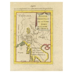
Antique map titled ?Partie Orientale de la Terre Ferme de l'Inde Moderne. Small map of India and the Gulf of Bengal. This map originates from a German edition of 'Description de l' Univers'.
Artists and Engravers: Alain Manesson Mallet (1630-1706) was a French cartographer and engineer. He started his career as a soldier in the army of Louis XIV, became a Sergeant-Major in the artillery and an Inspector of Fortifications. He also served under the King of Portugal, before returning to France, and his appointment to the court of Louis XIV. His military engineering and mathematical background led to his position teaching mathematics at court. His 'Description de L'Universe' contains a wide variety of information, including star maps...
Category
Antique 17th Century Maps
Materials
Paper
$334 Sale Price
20% Off
Antique Map of India as Described It Was before the 5th Century, 1744
Located in Langweer, NL
Antique map titled 'India, as described by all Authors before the fifth Century'. Detailed map of part of India, including Hyrcania, Parthia, Carmania, Gedorossii, Drangiana, Aria, M...
Category
Antique 18th Century Maps
Materials
Paper

$305 Sale Price
20% Off
1698 Mercator Ptolemaic Map of Asia East of the Ganges
Located in Langweer, NL
**Catalogue Description:**
**Title:** Tab. XI. Asiae, comprehendens Indiam extra Gangem.
**Description:**
This is an exquisite Ptolemaic map depicting Asia east of the Ganges, ti...
Category
Antique 1680s Maps
Materials
Paper

$898 Sale Price
20% Off
Detailed Original Antique Map of India, Southeast Asia and the Far East, 1719
Located in Langweer, NL
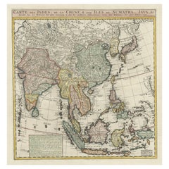
Antique map titled 'Carte des Indes, de la Chine & des Iles de Sumatra, Java & c'.
Detailed map of India, Southeast Asia and the Far East, extending from Gujerat to the supposed "T...
Category
Antique 1710s Maps
Materials
Paper
$1,671 Sale Price
20% Off
You May Also Like
Antique French Map of Asia Including China Indoneseia India, 1783
Located in Amsterdam, Noord Holland
Very nice map of Asia. 1783 Dedie au Roy.
Additional information:
Country of Manufacturing: Europe
Period: 18th century Qing (1661 - 1912)
Condition: Overall Condition B (Good Used)...
Category
Antique 18th Century European Maps
Materials
Paper

$648 Sale Price
20% Off
Original Antique Map of India by Dower, circa 1835
Located in St Annes, Lancashire
Nice map of India
Drawn and engraved by J.Dower
Published by Orr & Smith. C.1835
Unframed.
Free shipping
Category
Antique 1830s English Maps
Materials
Paper

Antique 1803 Italian Map of Asia Including China Indoneseia India
Located in Amsterdam, Noord Holland
Antique 1803 Italian Map of Asia Including China Indoneseia India
Very nice map of Asia. 1803.
Additional information:
Type: Map
Country of Manufacturing: Europe
Period: 19th centu...
Category
Antique 19th Century European Maps
Materials
Paper

$584 Sale Price
20% Off
Map Of India - Original Lithograph - 19th Century
Located in Roma, IT
Map of India is an original lithograph artwork realized by an Anonymous engraver of the 19th Century.
Printed in the series of "France Pittoresque".
Titled "France Pittoresque".
...
Category
19th Century Modern Figurative Prints
Materials
Lithograph

1627 Hendrik Hondius Map Entitled "Vltoniae Orientalis Pars, " Ric.a009
Located in Norton, MA
1627 Hendrik Hondius map entitled
"Vltoniae orientalis pars,"
Ric.a009
Title:
Vltoniae orientalis : pars
Title (alt.) :
Ultoniae orientalis pars
Creator:
Mercator, Gerh...
Category
Antique 17th Century Dutch Maps
Materials
Paper

1718 Ides & Witsen Map "Route D'amsterdam a Moscow Et De La Ispahan Et Gamron
Located in Norton, MA
1718 Ides & Witsen map, entitled
"Route D'Amsterdam A Moscow Et De La Ispahan Et Gamron,"
Ric.b005
Subject: Eastern Europe and Central Asia
Period: 1718 (published)
Publicati...
Category
Antique Early 18th Century Dutch Maps
Materials
Paper

More Ways To Browse
Japanese Compact
Live Edge Black Walnut
Indian Reverse Glass
Engraving Louis Xiv
Large Antique Tapestry
Mid Century Modern Corner Chair
Sterling Silver Flatware Set Service For 12
1970s Brass Glass Coffee Table
Mid Century Sofa Red
Painted Arm Chairs
Vintage Azerbaijan
Charles Rennie Mackintosh For Cassina
Painted Bar Stools
3x5 Rugs
French Iron And Glass Table
Mcm Table
Tufted Bar
Green Oushak