Items Similar to 1717 Johannes Van Keulen Sea Chart of the Eastern Atlantic - Amsterdam to Gambia
Want more images or videos?
Request additional images or videos from the seller
1 of 7
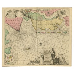
1717 Johannes Van Keulen Sea Chart of the Eastern Atlantic - Amsterdam to Gambia
$2,695.82
£2,006.49
€2,250
CA$3,692.60
A$4,106.98
CHF 2,144.54
MX$49,977.59
NOK 27,389.02
SEK 25,686.07
DKK 17,128.46
Shipping
Retrieving quote...The 1stDibs Promise:
Authenticity Guarantee,
Money-Back Guarantee,
24-Hour Cancellation
About the Item
1717 Johannes Van Keulen Sea Chart of the Eastern Atlantic - Amsterdam to Gambia
This 1717 sea chart by Johannes Van Keulen, titled "Nieuwe Paskaert vande Gheleele Westersche Scheep-vaert," beautifully illustrates the eastern Atlantic Ocean, extending from Amsterdam and the British Isles in the north to Gambia in the south.
The chart is centered on the Straits of Gibraltar and the Azores, providing detailed coastal information with clear depictions of important ports and geographic features.
Classic early 18th-century Dutch maritime craftsmanship is evident in the chart's decoration, which includes two compass roses, numerous rhumb lines for navigational plotting, and decorative cartouches illustrating scenes of maritime life. A cherub carrying a coat of arms and two sailing ships embellish the scene, with a sea monster adding an element of mythical intrigue. The map is oriented with east at the top, and the hand coloring is vibrant, accentuating its details.
Johannes Van Keulen was an influential figure in Dutch cartography, founding the firm "In de Gekroonde Lootsman" (In the Crowned Pilot) in 1678, which became one of the most prominent maritime chartmakers of the era. His business flourished through the publication of the "Zee-Atlas" (Sea Atlas) and "Nieuwe Lichtende Zee-Fakkel" (New Shining Sea Torch), securing a reputation for accuracy and artistic quality. After Johannes' death, his son Gerard and later generations continued the family business, even supplying charts to the Dutch East India Company (VOC).
This chart reflects the golden age of Dutch maritime exploration, depicting the navigational routes and coastal details crucial to seafarers in the early 18th century. It serves not only as a navigational tool but also as a testament to the artistry and precision of Dutch cartography during this influential period in maritime history.
The 1717 sea chart by Johannes Van Keulen highlights several key islands and important geographic points in the eastern Atlantic region, extending from Amsterdam to Gambia, focusing on the waters of Western Europe and Africa. Below are the main islands and notable features depicted on the map:
main islands:
1. azores (de azoren)
- prominently featured near the center of the map, the azores are a key cluster of islands used as an important stopover for ships crossing the atlantic.
2. canary islands (de canarische eylanden)
- located off the northwest coast of africa, these islands are detailed with individual island names marked. they were significant for navigation and resupply points for ships heading south or west.
3. madeira (madeira)
- madeira is depicted along with porto santo, located further north of the canary islands. this portuguese archipelago was an essential waypoint for atlantic explorers and traders.
4. cape verde islands (de eylanden van caep verde)
- situated off the coast of senegal, the cape verde islands were crucial for ships traveling between europe, africa, and the americas. each of the islands is depicted and labeled.
other important geographic points:
1. strait of gibraltar
- the map prominently shows the strait of gibraltar, the narrow entrance between the atlantic ocean and the mediterranean sea, an area of critical importance for maritime trade and naval navigation.
2. western european coast
- the coastline of western europe, including parts of spain, portugal, and france, is detailed, highlighting important coastal features, ports, and cities. the detailed rendering of these coastlines was vital for ships navigating nearshore waters.
3. british isles and ireland
- parts of southern england, ireland, and scotland are included, showing major ports and providing a broader view of the navigational context along western europe.
4. west african coast
- the map extends south to gambia on the western coast of africa, covering notable points like the senegal river and coastal trading areas that were significant during the era of european exploration and the slave trade.
decorative elements and cartouches:
1. compass roses and rhumb lines
- there are two compass roses, along with an intricate network of rhumb lines that cover the entire map, allowing navigators to chart their course across the open sea effectively.
2. decorative cartouches
- the decorative cartouches, including one with figures of sailors, natives, and explorers, reflect maritime themes and the exotic allure of the lands explored by dutch seafarers. a cherub carrying a coat of arms above the mediterranean also adds visual flair.
3. sea monsters and ships
- the map features sailing ships and sea monsters, adding both a decorative and navigational reference to help mariners and captivate those interested in maritime myths.
orientation:
- east is at the top
- notably, the map is oriented with east at the top, a unique approach to orientation that was common among sea charts during this time, emphasizing the importance of different directions for navigational purposes.
these islands and geographic points were significant for seafaring trade routes, providing essential stopovers for provisioning, navigation, and establishing control over atlantic maritime pathways during the height of european exploration and colonial expansion.
The map is in good condition with vibrant original hand-coloring, intact margins, and minor toning along the edges. There are light creases from the central fold but no significant tears. Decorative cartouches and engraving details remain clear and crisp.
- Dimensions:Height: 20.87 in (53 cm)Width: 23.82 in (60.5 cm)Depth: 0.01 in (0.2 mm)
- Materials and Techniques:Paper,Engraved
- Period:1710-1719
- Date of Manufacture:1717
- Condition:The map is in good condition with vibrant original hand-coloring, intact margins, and minor toning along the edges. There are light creases from the central fold but no tears. Decorative cartouches and engraving details remain clear and crip.
- Seller Location:Langweer, NL
- Reference Number:Seller: BHZ102361stDibs: LU3054342599192
About the Seller
5.0
Recognized Seller
These prestigious sellers are industry leaders and represent the highest echelon for item quality and design.
Platinum Seller
Premium sellers with a 4.7+ rating and 24-hour response times
Established in 2009
1stDibs seller since 2017
2,508 sales on 1stDibs
Typical response time: <1 hour
- ShippingRetrieving quote...Shipping from: Langweer, Netherlands
- Return Policy
Authenticity Guarantee
In the unlikely event there’s an issue with an item’s authenticity, contact us within 1 year for a full refund. DetailsMoney-Back Guarantee
If your item is not as described, is damaged in transit, or does not arrive, contact us within 7 days for a full refund. Details24-Hour Cancellation
You have a 24-hour grace period in which to reconsider your purchase, with no questions asked.Vetted Professional Sellers
Our world-class sellers must adhere to strict standards for service and quality, maintaining the integrity of our listings.Price-Match Guarantee
If you find that a seller listed the same item for a lower price elsewhere, we’ll match it.Trusted Global Delivery
Our best-in-class carrier network provides specialized shipping options worldwide, including custom delivery.More From This Seller
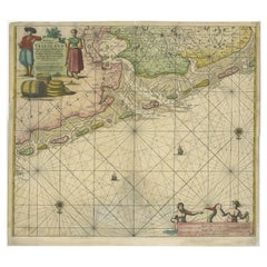
View AllRare North Atlantic and Caribbean Sea Chart: Newfoundland to Venezuela, 1745
Located in Langweer, NL
This impressive map titled "Terra Neuf, en de Custen van Nieu Vranckryck, Nieuw Engeland... Venezuela," published by Louis Renard in 1745, captures the North Atlantic coastline, enco...
Category
Antique 1740s Maps
Materials
Paper
Sea Chart of Central America and the Northwest Coast of South America, ca.1745
Located in Langweer, NL
Antique map titled 'Novae Hispaniae, Chili, Peruviae et Guatamala Littorae.'
Sea chart of Central America and the northwest coast of South America, oriented to the east, by Reinier & Joshua Ottens (after Frederick de Wit - 1675) in 1745 ('Atlas van de Zeevaart'). The map shows all or parts of the coasts of Peru, Chili, Honduras, Costa Rica and Mexico as well as the western Caribbean and the Galapagos...
Category
Antique 1740s Maps
Materials
Paper
$2,348 Sale Price
20% Off
Free Shipping
Rare Sea Chart of the East Frisian Islands or Watten and the North Sea, c.1700
Located in Langweer, NL
Description: Antique map titled 'Paskaarte van de rievier de Elve streckende van Oldenbroek tot Hamburgh.'
Rare and interesting chart of the East Frisian Islands (or Watten) and ...
Category
Antique Early 1700s Maps
Materials
Paper
$1,773 Sale Price
20% Off
Old Decorative & Highly Detailed Sea Chart of the North Dutch-German Coast, 1681
Located in Langweer, NL
Antique map titled 'Paskaart van een gedeelte van Vriesland, Groeninger, en Emderland. Met zyn onderhoorige Eylanden; Strekkende van't Eylant der Schelling'.
Decorative and highl...
Category
Antique 1680s Maps
Materials
Paper
$1,581 Sale Price
20% Off
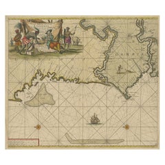
Antique Sea Chart of the Western Coast of Africa
Located in Langweer, NL
Antique map titled 'Nieuwe Paskaert van de Kust van Genehoa (..)'. This attractive sea chart covers the western coast of Africa from Cape Blanco (Ras Nouadhibou) to Cape Verde (Dakar...
Category
Antique Late 17th Century Maps
Materials
Paper
$853 Sale Price
20% Off
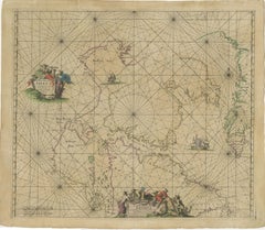
1690 Frederick de Wit Sea Chart of Hudson Bay, Baffin Bay and Greenland
Located in Langweer, NL
Title: c. 1690 Frederick de Wit Sea Chart of Hudson Bay, Baffin Bay, and Greenland - Engraved by Romeyn de Hooghe
This striking sea chart by Frederick de Wit, titled "Septemtrionali...
Category
Antique 1690s Maps
Materials
Paper
You May Also Like
Antique Map - Mare Pacificum - Etching by Johannes Janssonius - 1650s
By Johannes Janssonius
Located in Roma, IT
Mare Pacificum is an antique map realized in 1650 by Johannes Janssonius (1588-1664).
The Map is Hand-colored etching, with coeval watercolorang.
Good conditions with slight foxing...
Category
1650s Modern Figurative Prints
Materials
Etching

West Coast of Africa, Guinea & Sierra Leone: An 18th Century Map by Bellin
By Jacques-Nicolas Bellin
Located in Alamo, CA
Jacques Bellin's copper-plate map entitled "Partie de la Coste de Guinee Dupuis la Riviere de Sierra Leona Jusquau Cap das Palmas", depicting the coast of Guinea and Sierra Leone in ...
Category
Antique Mid-18th Century French Maps
Materials
Paper

Indiarum Occidentalium Tractus Littorales cum Insulis Caribicis / Pascaert van W
By Louis Renard
Located in New York, NY
This early 18th-century engraved map was published by Louis Renard in Amsterdam. The image size is 19 x 22 " (48.3 x 55.9 cm) plus margins.
A beautifully engraved Dutch sea chart. Shown is the entire Caribbean basin including the eastern seaboard up to Cape Cod and includes Bermuda. Florida is shown with the classic flattened southeastern coast that was derived by Hessel Gerritz. Noted are the routes taken by the Spanish treasure...
Category
18th Century Other Art Style More Prints
Materials
Engraving

Antique Map - Mar Di Athiopia - Etching by Johannes Janssonius - 1650s
By Johannes Janssonius
Located in Roma, IT
Antique Map - Mar Di Athiopia is an antique map realized in 1650 by Johannes Janssonius (1588-1664).
The Map is Hand-colored etching, with coeval watercolorang.
Good conditions wit...
Category
1650s Modern Figurative Prints
Materials
Etching

West Coast of Africa; Guinea & Sierra Leone: Bellin 18th Century Map
Located in Alamo, CA
This is a Jacques Bellin copper-plate map entitled "Partie de la Coste de Guinee Dupuis la Riviere de Sierra Leona Jusquau Cap das Palmas", depicting the coast of Guinea and Sierra L...
Category
1740s Old Masters Landscape Prints
Materials
Engraving

Antique Map - Gallia - Etching by Johannes Janssonius - 1650s
By Johannes Janssonius
Located in Roma, IT
Antique Map - Gallia is an antique map realized in 1650 by Johannes Janssonius (1588-1664).
The Map is Hand-colored etching, with coeval watercoloring.
Good conditions with slight ...
Category
1650s Modern Figurative Prints
Materials
Etching

More Ways To Browse
Eastern European Furniture
Southern Colonial
Voc Antique
French Santos
East India Trading Company
Sea Monster
Santos Figure
18th Century Naval
Dutch Sailing Ship
Spanish Santos
British East India Company
Colonial New England
18th Century Santos
Portuguese Colonial Furniture
British Compass
Flair Holland
Cape Dutch Furniture
Antique African Tools