Items Similar to 1742 Antique Map of the Persian Empire with Detailed Borders and Cartouche
Want more images or videos?
Request additional images or videos from the seller
1 of 12
1742 Antique Map of the Persian Empire with Detailed Borders and Cartouche
$1,940.99
£1,444.67
€1,620
CA$2,658.67
A$2,957.03
CHF 1,544.07
MX$35,983.87
NOK 19,720.10
SEK 18,493.97
DKK 12,332.49
Shipping
Retrieving quote...The 1stDibs Promise:
Authenticity Guarantee,
Money-Back Guarantee,
24-Hour Cancellation
About the Item
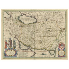
Title: 1742 Covens & Mortier Map of the Persian Empire by Guillaume De L'Isle
This remarkable 1742 map, "Carte de Perse," was originally designed by Guillaume De L'Isle, a preeminent geographer of his time, and published in Amsterdam by Covens & Mortier. The map offers a detailed representation of the Persian Empire, one of the most influential regions of the 18th century, spanning from the Black Sea to the Arabian Sea and from the Caspian Sea to the borders of the Indian subcontinent.
The map is richly detailed, with hand-colored outlines delineating the territories, including Persia (modern-day Iran), Armenia, Mesopotamia (Iraq), and parts of the Arabian Peninsula. Major cities, mountain ranges, rivers, and deserts are meticulously engraved, reflecting De L'Isle's commitment to accuracy. Additionally, the map extends into regions such as the Ottoman Empire, Central Asia, and northern India, offering a broader geopolitical context.
A beautifully designed title cartouche, adorned with allegorical figures, adds an artistic touch to this cartographic masterpiece. The upper margin bears the Latin title "Nova et accurata Imperii Persici delineatio ad usum serenissimi Burgundiae Ducis," indicating its high-quality design for a noble audience.
De L'Isle's maps are celebrated for their scientific rigor and elegance, and this map exemplifies his influence on cartography during the Enlightenment. It is a valuable piece for collectors of historical maps, particularly those focused on the Middle East and Central Asia.
Condition Report: The map is in very good to excellent condition for its age, with strong engraving and original hand-coloring. Light toning and minor foxing are visible, consistent with its age. Margins are intact, and no significant tears or repairs are noted.
Framing and Matting Tips:
To emphasize the map's historical and artistic qualities, use an archival-quality mat in cream or soft beige tones. Pair it with an ornate gold or dark wooden frame to complement the decorative cartouche. UV-protective glass is essential to preserve the hand-coloring and prevent fading. Adding a descriptive plaque highlighting the map's significance would make it a centerpiece in any collection or display.
- Dimensions:Height: 22.25 in (56.5 cm)Width: 25.99 in (66 cm)Depth: 0.01 in (0.2 mm)
- Materials and Techniques:Paper,Engraved
- Place of Origin:
- Period:1740-1749
- Date of Manufacture:1742
- Condition:Condition Report: The map is in excellent condition for its age, with strong engraving and original hand-coloring. Light toning and minor foxing are visible, consistent with its age. Margins are intact, and no significant tears or repairs are noted.
- Seller Location:Langweer, NL
- Reference Number:Seller: BG-140471stDibs: LU3054343437962
About the Seller
5.0
Recognized Seller
These prestigious sellers are industry leaders and represent the highest echelon for item quality and design.
Platinum Seller
Premium sellers with a 4.7+ rating and 24-hour response times
Established in 2009
1stDibs seller since 2017
2,508 sales on 1stDibs
Typical response time: <1 hour
- ShippingRetrieving quote...Shipping from: Langweer, Netherlands
- Return Policy
Authenticity Guarantee
In the unlikely event there’s an issue with an item’s authenticity, contact us within 1 year for a full refund. DetailsMoney-Back Guarantee
If your item is not as described, is damaged in transit, or does not arrive, contact us within 7 days for a full refund. Details24-Hour Cancellation
You have a 24-hour grace period in which to reconsider your purchase, with no questions asked.Vetted Professional Sellers
Our world-class sellers must adhere to strict standards for service and quality, maintaining the integrity of our listings.Price-Match Guarantee
If you find that a seller listed the same item for a lower price elsewhere, we’ll match it.Trusted Global Delivery
Our best-in-class carrier network provides specialized shipping options worldwide, including custom delivery.More From This Seller
View AllMap of the Persian Empire by Nicolas Sanson, Hand-colored, circa 1683
Located in Langweer, NL
Map of the Persian Empire by Nicolas Sanson, hand-colored, circa 1683
This finely detailed and delicately hand-colored map titled *L'Empire du Sophy des Perses* presents a late 17th...
Category
Antique 1680s Maps
Materials
Paper
Map of the Persian Empire circa 1750 by Tirion – Hand-Colored Dutch Map
Located in Langweer, NL
Map of the Persian Empire circa 1750 by Tirion – Hand-Colored Dutch Map
This finely detailed antique map titled "Nieuwe Kaart van 't Ryk van Persie" (New Map of the Empire of Persia...
Category
Antique 1750s Dutch Maps
Materials
Paper
Authentic Old Map of Persia with Original Border Coloring, 1745
Located in Langweer, NL
Title: "Kaartje van Persien na de stelling van den Heer Guillaume de L'Isle"
Translates to "Map of Persia based on the work of Mr. Guillaume de L'Isle." Guillaume de L'Isle was a p...
Category
Antique 1740s Maps
Materials
Paper

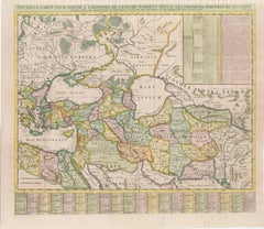
18th-Century Map of the Eastern Roman Empire by Henri Chatelain, c. 1719
Located in Langweer, NL
Title: 18th-Century Map of the Eastern Roman Empire by Henri Chatelain, c. 1719
Description: This intricately detailed map, titled *Nouvelle Carte pour Servir à l'Histoire de l'Empi...
Category
Antique 1710s Maps
Materials
Paper
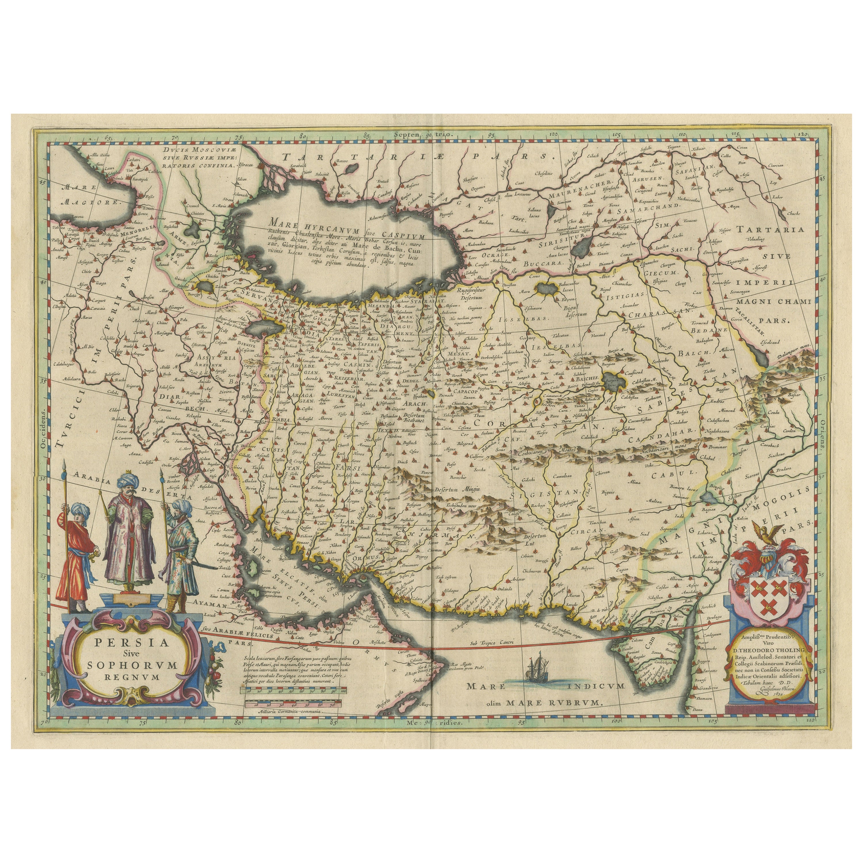
Antique Map of Persia with Dedication Cartouche
Located in Langweer, NL
Antique map titled 'Persia sive Sophorum Regnum'. Original old map of Persia. The map extends from the Eastern Mediteranian to Tacalistan and the Indus River and the Dalanguer Mounta...
Category
Antique Mid-17th Century Maps
Materials
Paper
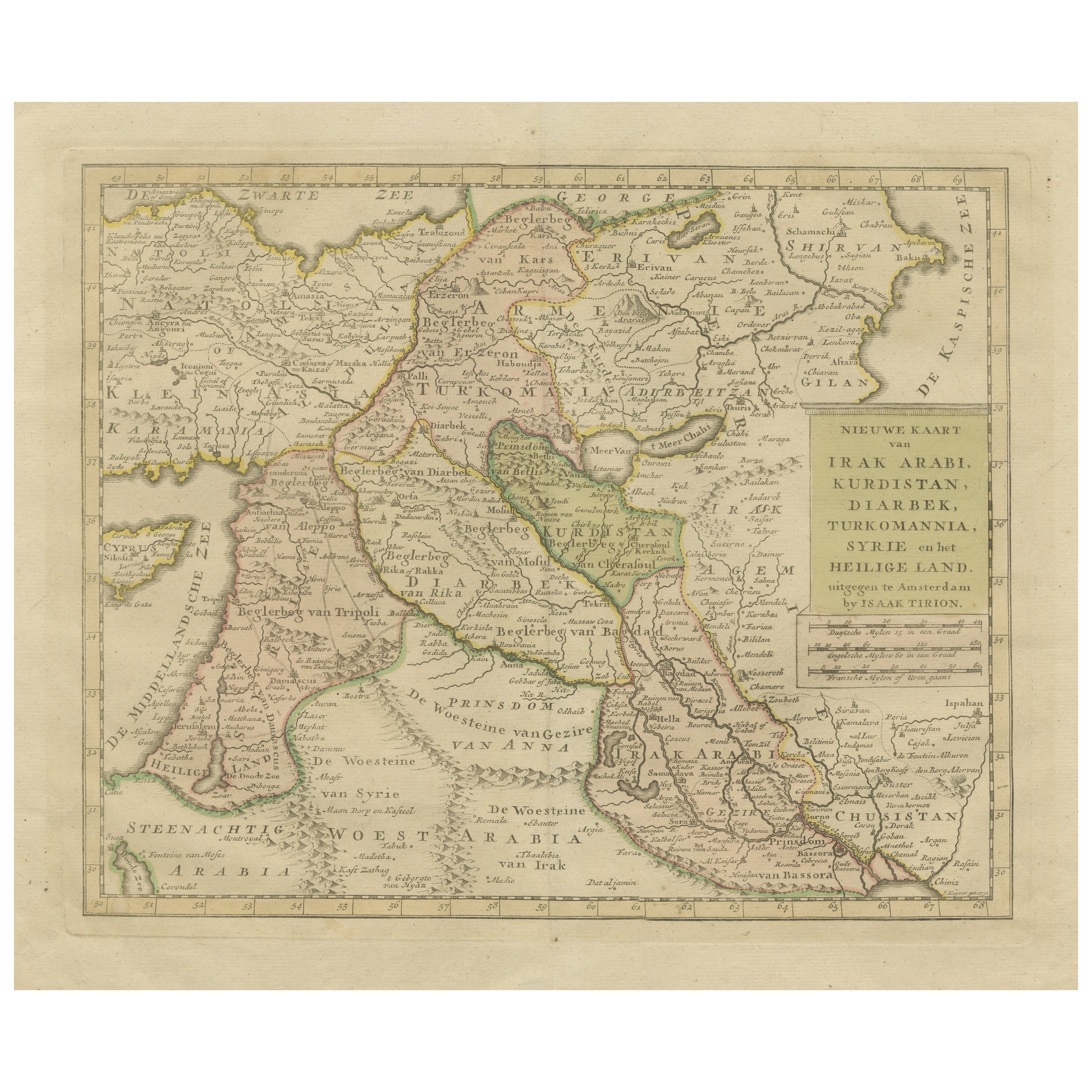
Antique Map of Eastern Turkey, Caucasus, Israel through Iraq and part of Arabia
Located in Langweer, NL
Antique map titled 'Nieuwe Kaart van Irak Arabia, Kurdistan, Diarbek, Turkomannia, Syrie en het Heilige Land'. Beautiful map including eastern Turkey, the Caucasus, Israel through Ir...
Category
Antique Mid-18th Century Maps
Materials
Paper

$440 Sale Price
20% Off
You May Also Like
Persia, Armenia & Adjacent Regions: A 17th Century Hand-colored Map by De Wit
By Frederick de Wit
Located in Alamo, CA
A large 17th century hand colored copperplate engraved map entitled "Novissima nec non Perfectissima Scandinaviae Tabula comprehendens Regnorum Sueciae, Daniae et Norvegiae distincte...
Category
Antique Late 17th Century Dutch Maps
Materials
Paper

Persia, Armenia & Adjacent Regions: A Hand-colored 17th Century Map by De Wit
By Frederick de Wit
Located in Alamo, CA
This colorful and detailed 17th century copperplate map by Frederick De Wit was published in Amsterdam between 1666 and 1690. It depicts the Caspian Se...
Category
Late 17th Century Old Masters More Prints
Materials
Engraving

Antique French Map of Asia Including China Indoneseia India, 1783
Located in Amsterdam, Noord Holland
Very nice map of Asia. 1783 Dedie au Roy.
Additional information:
Country of Manufacturing: Europe
Period: 18th century Qing (1661 - 1912)
Condition: Overall Condition B (Good Used)...
Category
Antique 18th Century European Maps
Materials
Paper

$648 Sale Price
20% Off
1718 Ides & Witsen Map "Route D'amsterdam a Moscow Et De La Ispahan Et Gamron
Located in Norton, MA
1718 Ides & Witsen map, entitled
"Route D'Amsterdam A Moscow Et De La Ispahan Et Gamron,"
Ric.b005
Subject: Eastern Europe and Central Asia
Period: 1718 (published)
Publicati...
Category
Antique Early 18th Century Dutch Maps
Materials
Paper

Original Antique Map of Ancient Greece- Boeotia, Thebes, 1787
Located in St Annes, Lancashire
Great map of Ancient Greece. Showing the region of Boeotia, including Thebes
Drawn by J.D. Barbie Du Bocage
Copper plate engraving by P.F T...
Category
Antique 1780s French Other Maps
Materials
Paper

"Nova Barbariae Descriptio", a 17th Century Hand-Colored Map of North Africa
By Johannes Janssonius
Located in Alamo, CA
This original attractive 17th century hand-colored map of North Africa entitled "Nova Barbariae Descriptio" by Johannes Janssonius was published in Paris in 1635. It includes the Med...
Category
Antique Mid-17th Century Dutch Maps
Materials
Paper

More Ways To Browse
Gold Cartouche
Black And Gold Ottoman
Iran Map
Bear Ottoman
Wooden Indian Figures
Arabia Plaque
Carlo Scarpa 1934 Chairs
Christofle Marly
1900 Antique Chairs
Glass Table Italian Round
Alvar Aalto Poster
Geometric Metal Table
Post Modern High Chairs
Vintage Vine Rug
Cancel An Order
Antique Framing Square
Silver Metal Chair
Swedish Kilim