Items Similar to 1792 Map of Eastern Africa and the Arabian Peninsula by Delisle/Elwe

Want more images or videos?
Request additional images or videos from the seller
1 of 6
1792 Map of Eastern Africa and the Arabian Peninsula by Delisle/Elwe
$632.62
$790.7720% Off
£470.94
£588.6820% Off
€528
€66020% Off
CA$866.53
CA$1,083.1620% Off
A$963.77
A$1,204.7120% Off
CHF 503.25
CHF 629.0620% Off
MX$11,728.08
MX$14,660.0920% Off
NOK 6,427.29
NOK 8,034.1120% Off
SEK 6,027.66
SEK 7,534.5820% Off
DKK 4,019.48
DKK 5,024.3520% Off
Shipping
Retrieving quote...The 1stDibs Promise:
Authenticity Guarantee,
Money-Back Guarantee,
24-Hour Cancellation
About the Item
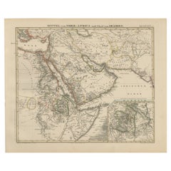
1792 Map of Eastern Africa and the Arabian Peninsula by Delisle/Elwe
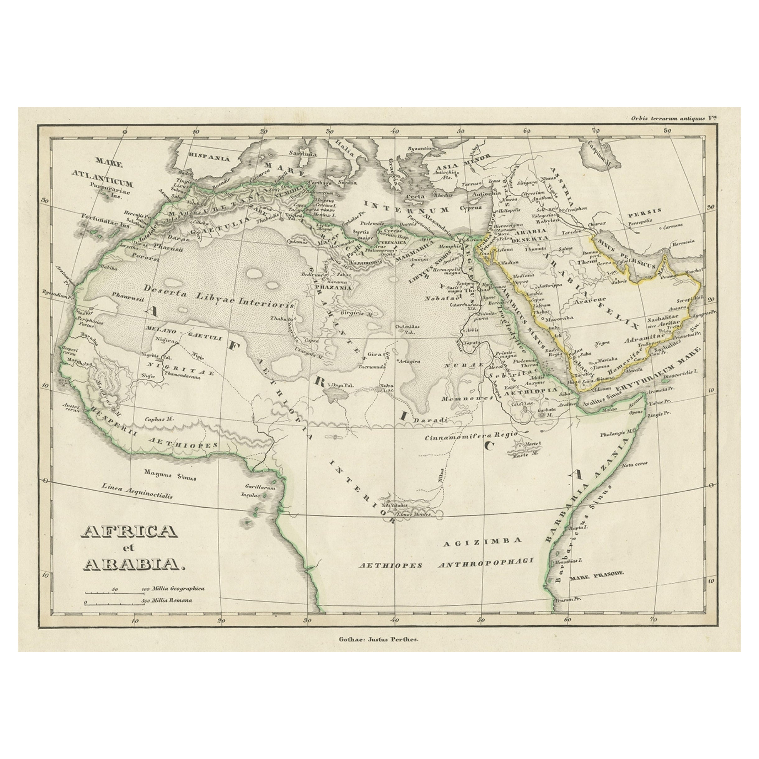
This detailed 1792 map, created by Delisle and published by Elwe, depicts northeastern Africa, including Egypt, Nubia, and Abyssinia, along with the Red Sea and Arabian Peninsula. It highlights the political divisions, kingdoms, roads, topographical features, settlements, and encampments of the region.
Notable features include the Nile River, originating from the mountains near Lake Dambee, and various annotations about tribes, trade routes, and locations of valuable emeralds.
Other key places and terms of interest:
1. Egypt (Egypte) - One of the main regions depicted, including the Nile River and the city of Cairo (Kaire).
2. Nubia (Nubie) - Located south of Egypt, known for its historical significance and ancient kingdoms.
3. Abyssinia (Abissinie) - Refers to the historical region of modern-day Ethiopia, noted for its ancient civilization and cultural heritage.
4. Red Sea (Mer Rouge) - The map details the western coastline of the Red Sea, important for historical trade routes.
5. Arabian Peninsula (Peninsule Arabique) - Shows parts of present-day Saudi Arabia, including areas like the Gulf of Persia (Persian Gulf).
6. Nile River - The source of the Nile is marked near the mountains by Lake Dambee, an important feature for geographical and historical studies.
7. Sinai Peninsula - Part of the Arabian desert area shown on the map, significant for its biblical and historical references.
8. Sahara Desert (Desert de Barbarie) - Large portions of the Sahara are labeled, including various tribes and nomadic groups.
9. Mogadishu (Mogadiscio) - Part of the area in the southeastern corner of the map, which relates to the region of modern Somalia.
10. Emerald Mines - The map notes the location of emeralds, which might attract those interested in the natural resources and historical trade of the region.
11. Trade Routes and Tribal Areas - Various trade routes and tribal areas are marked, which would interest those studying ancient trade networks and cultural interactions.
Measuring 22.3 inches wide by 19.2 inches high, the map retains its original colors on watermarked paper. Despite minor staining along the centerfold and a repaired chip near the top affecting the title, it remains a crisp and informative historical document.
- Dimensions:Height: 19.2 in (48.77 cm)Width: 22.3 in (56.65 cm)Depth: 0.002 in (0.06 mm)
- Materials and Techniques:Paper,Engraved
- Period:1790-1799
- Date of Manufacture:1792
- Condition:Good, considering age. Despite minor staining along the centerfold and a repaired chip near the top affecting the title, it remains a crisp and informative historical document.
- Seller Location:Langweer, NL
- Reference Number:Seller: BG-138591stDibs: LU3054341276522
About the Seller
5.0
Recognized Seller
These prestigious sellers are industry leaders and represent the highest echelon for item quality and design.
Platinum Seller
Premium sellers with a 4.7+ rating and 24-hour response times
Established in 2009
1stDibs seller since 2017
2,510 sales on 1stDibs
Typical response time: <1 hour
- ShippingRetrieving quote...Shipping from: Langweer, Netherlands
- Return Policy
Authenticity Guarantee
In the unlikely event there’s an issue with an item’s authenticity, contact us within 1 year for a full refund. DetailsMoney-Back Guarantee
If your item is not as described, is damaged in transit, or does not arrive, contact us within 7 days for a full refund. Details24-Hour Cancellation
You have a 24-hour grace period in which to reconsider your purchase, with no questions asked.Vetted Professional Sellers
Our world-class sellers must adhere to strict standards for service and quality, maintaining the integrity of our listings.Price-Match Guarantee
If you find that a seller listed the same item for a lower price elsewhere, we’ll match it.Trusted Global Delivery
Our best-in-class carrier network provides specialized shipping options worldwide, including custom delivery.More From This Seller
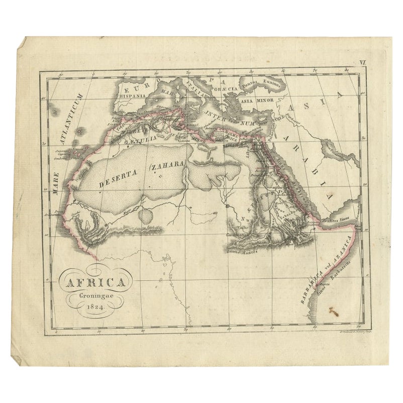
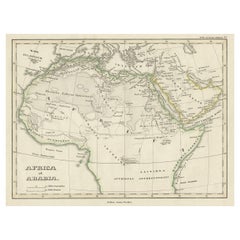
View AllOld Original Map of Africa and Arabia, 1848
Located in Langweer, NL
Antique map titled 'Africa et Arabia'.
Old map of Africa and Arabia originating from 'Orbis Terrarum Antiquus in usum Scholarum'.
Artists and Engravers: Published by Justus P...
Category
Antique 1840s Maps
Materials
Paper
$124 Sale Price
20% Off
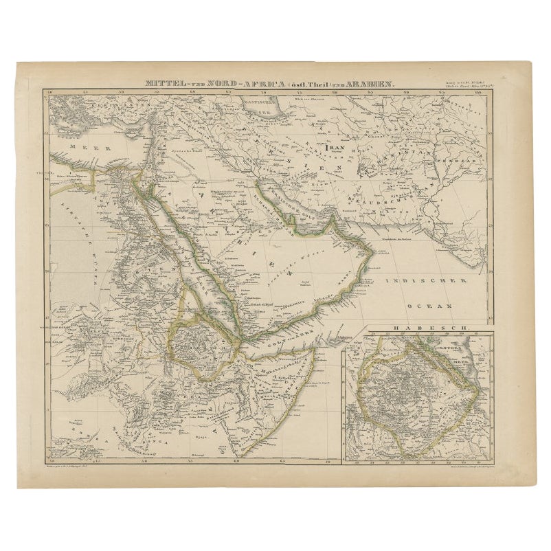
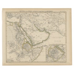
Antique Map of Africa and Arabia with Inset Map of Ethiopia and Eritrea, 1845
Located in Langweer, NL
Antique map titled 'Mittel- und Nord-Africa (östl. Theil) und Arabien'. This map depicts North and Central Africa and Arabia with an inset map of Habesch (Ethiopia and Eritrea).
Ar...
Category
Antique 19th Century Maps
Materials
Paper
$210 Sale Price
20% Off
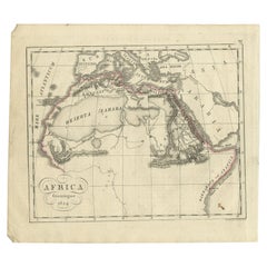
Antique Map of Northern Africa from a Rare Dutch Atlas, 1825
Located in Langweer, NL
Antique map titled 'Africa'. Old map of the African continent originating from 'Atlas der Oude Wereld'.
Artists and Engravers: Published by C. Ph. Funke and W. van Boekeren, Gron...
Category
Antique 19th Century Maps
Materials
Paper
$115 Sale Price
20% Off
Antique Map of the Arabian Peninsula by Bonne 'c.1780'
Located in Langweer, NL
Antique map titled 'Carte de l'Arabie, du Golfe Persique, et de la Mer Rouge (..)'. Original antique map of the Arabian Peninsula, including the horn...
Category
Antique Late 18th Century Maps
Materials
Paper

$479 Sale Price
20% Off
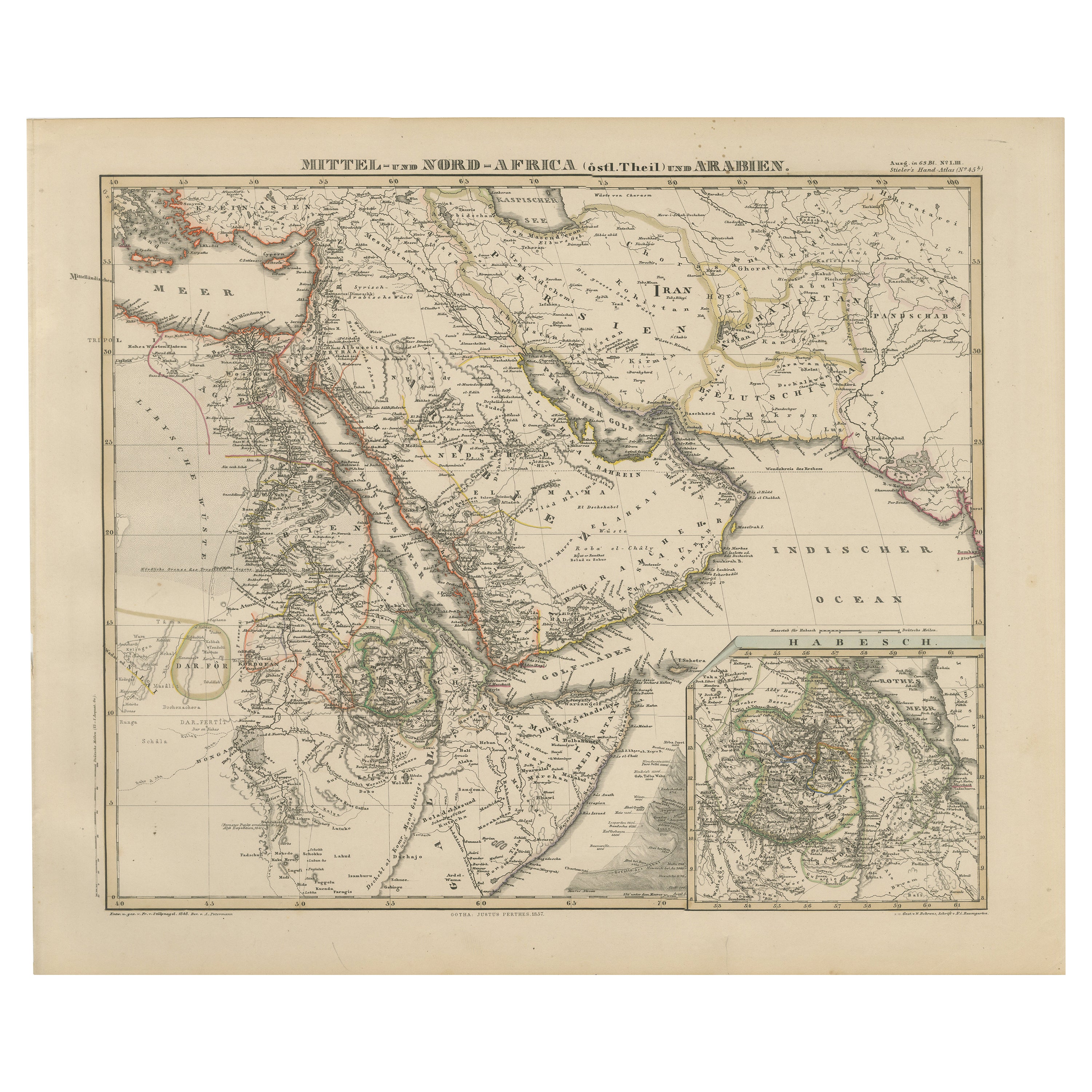
Historic 1857 Map of North-East Africa & Arabia – Fine Engraving
Located in Langweer, NL
North-East Africa and Arabia Map 1857
This detailed antique print shows “Mittel- und Nord-Afrika (östl. Theil) und Arabien” meaning “Central and North Africa (eastern part) and Arab...
Category
Antique Mid-19th Century German Maps
Materials
Paper
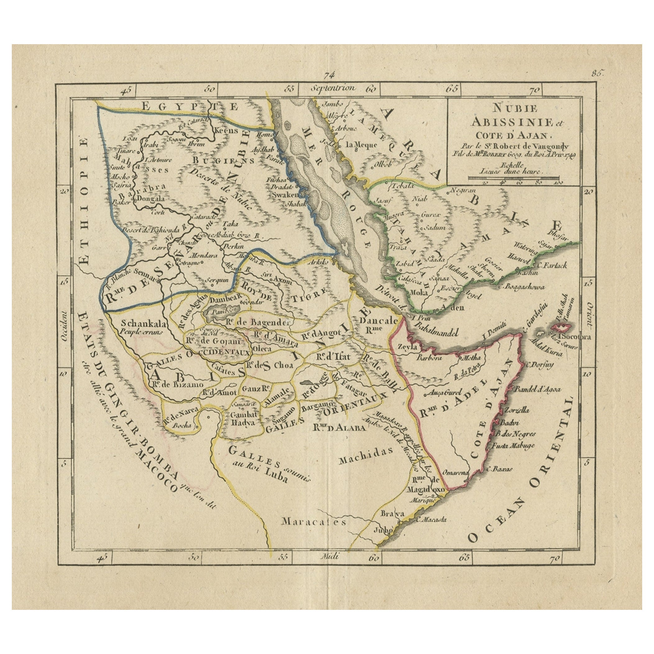
Original Antique Map of Abyssinia, Sudan and the Red Sea, 1749
Located in Langweer, NL
Antique map titled 'Nubie, Abissinie et Cote d'Ajan'.
Map of Abyssinia, Sudan and the Red Sea by Robert Vaugondy. Covers from Arabia and Egypt south to M...
Category
Antique 1740s Maps
Materials
Paper
$325 Sale Price
20% Off
You May Also Like
Original Antique Map of Africa by Dower, circa 1835
Located in St Annes, Lancashire
Nice map of Africa
Drawn and engraved by J.Dower
Published by Orr & Smith. C.1835
Unframed.
Free shipping
Category
Antique 1830s English Maps
Materials
Paper

"Africa Vetus": a 17th Century Hand-Colored Map by Sanson
By Nicolas Sanson
Located in Alamo, CA
This original hand-colored copperplate engraved map of Africa entitled "Africa Vetus, Nicolai Sanson Christianiss Galliar Regis Geographi" was originally created by Nicholas Sanson d...
Category
Antique Late 17th Century French Maps
Materials
Paper

Africa. North-East Part. Century Atlas antique vintage map
Located in Melbourne, Victoria
'The Century Atlas. Africa. North-East Part'
Original antique map, 1903.
Inset map of 'Nile Delta and Suez Canal'.
Central fold as issued. Map name and nu...
Category
Early 20th Century Victorian More Prints
Materials
Lithograph

London 1744 Published Watercolour Antique Map of East Africa by Eman Bowen
Located in West Sussex, Pulborough
We are delighted to offer for sale this New and Accurate Map of Nubia & Abissinia, together with all the Kingdoms Tributary Thereto, and bordering upon them published in 1744 by Emanuel Bowen
This is a decorative antique engraved map of East Africa...
Category
Antique 1740s English George III Maps
Materials
Paper

Africa: A Large 17th Century Hand-Colored Map by Sanson and Jaillot
By Nicolas Sanson
Located in Alamo, CA
This large original hand-colored copperplate engraved map of Africa entitled "L'Afrique divisee suivant l'estendue de ses principales parties ou sont distingues les uns des autres, L...
Category
Antique 1690s French Maps
Materials
Paper

Africa. Central. Century Atlas antique vintage map
Located in Melbourne, Victoria
'The Century Atlas. Africa. Central'
Inset map of 'Madagascar'.
Original antique map, 1903.
Central fold as issued. Map name and number printed on the reverse corners.
Sheet 29.5cm...
Category
Early 20th Century Victorian More Prints
Materials
Lithograph

More Ways To Browse
Arabian Antique
Antique Furniture South Africa
Sahara Desert
Coffee Table Black Italian Modern
Christofle America
Iranian Silk Rug Carpet
Poul Moller
Tables With Inlaid Wood
World War Table
Antonio Jacobsen
Ariston Chairs
Coffee Tables Europe
Marble Top Dining Tables
Nordiska Argentina
Pink And Black Rug
Black Wooden Chair
Orrefors Embassy
Black Ebonized