Items Similar to 1817 Map of Puerto Rico and the Virgin Islands with Original Hand Coloring
Want more images or videos?
Request additional images or videos from the seller
1 of 6
1817 Map of Puerto Rico and the Virgin Islands with Original Hand Coloring
$354.65
$443.3120% Off
£264.01
£330.0220% Off
€296
€37020% Off
CA$485.78
CA$607.2320% Off
A$540.30
A$675.3720% Off
CHF 282.13
CHF 352.6620% Off
MX$6,574.83
MX$8,218.5420% Off
NOK 3,603.18
NOK 4,503.9720% Off
SEK 3,379.15
SEK 4,223.9320% Off
DKK 2,253.34
DKK 2,816.6820% Off
Shipping
Retrieving quote...The 1stDibs Promise:
Authenticity Guarantee,
Money-Back Guarantee,
24-Hour Cancellation
About the Item
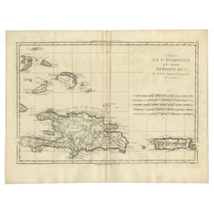
The title provided for this map is "Porto Rico and Virgin Isles," and it is an antique map from an early 19th century atlas, dated 1817, featuring original hand coloring. This historic map showcases the geographical layout of Puerto Rico and the nearby Virgin Islands, including St. Thomas and St. Croix. The hand coloring is used to highlight different elevations and terrains, such as mountain ranges, valleys, and coastal areas.
The age of the map, over 200 years old, is reflected in the paper's tone and the style of cartography. Despite its age, the map's lines and text are remarkably clear, indicating that it has been well-preserved. The fine detail in the engraving and the careful application of color demonstrate the high level of craftsmanship that went into making maps during this period. Maps like this one would have been important for navigation and trade in the Caribbean during the 19th century, as well as being valuable items for those interested in the region’s geography.
The overall condition of the map appears to be good, with paper coloration consistent with its age. There might be some slight foxing or age-related toning, but it does not detract from the legibility or aesthetic quality of the map. The neat lines and margins are well-preserved, and the text is clear, suggesting the map has been well cared for over the years. However, the bottome has been enforced neatly and there is one tear not touching the image. The engraving is precise, and the hand coloring is applied with skill, which enhances the visual appeal of the map. This piece would have served as both a practical guide for navigation and a work of art for those interested in the geography of the West India Islands during the time it was created.
More info about the maker:
John Thomson was a notable Scottish cartographer from the late 18th and early 19th centuries. He was active in Edinburgh, which was a center for Enlightenment science, literature, and education, and it became an important hub for cartographic publishing during that time.
Thomson's work is best known for its accuracy, detail, and the aesthetic appeal of his maps. He published "Thomson's New General Atlas" around 1817, which was considered one of the most detailed world atlases of the time. This work was significant for its use of dramatic color and for including updates based on new discoveries and contemporary geopolitical changes.
Thomson's maps were also distinctive for their lack of decorative embellishments, which were common in maps of the earlier periods. Instead, he focused on the clarity and functionality of the cartographic information, which made his maps particularly useful for navigators and scholars. The quality of the paper and printing techniques used by Thomson were also superior for the time, contributing to the longevity and crisp appearance of his maps.
The New General Atlas by John Thomson included detailed maps of countries from around the world, reflecting the state of geographic knowledge during the Regency period. His works remain valuable to collectors and historians for their representation of historical geography and as artifacts of the cartographic arts of the early 19th century.
- Dimensions:Height: 25.99 in (66 cm)Width: 11.03 in (28 cm)Depth: 0 in (0.02 mm)
- Materials and Techniques:Paper,Engraved
- Period:
- Date of Manufacture:1817
- Condition:Additions or alterations made to the original: The lower margin has been enforced as the this map was the upper part of a page with Haiti, but split in two. Good condition considering its age. Flattened folding lines and one tear at the bottom not reaching the image. Original Bordercoloring. Minor foxing. Study image carefully. Ideal for framing or matting.
- Seller Location:Langweer, NL
- Reference Number:Seller: BG-31619-131stDibs: LU3054337731242
About the Seller
5.0
Recognized Seller
These prestigious sellers are industry leaders and represent the highest echelon for item quality and design.
Platinum Seller
Premium sellers with a 4.7+ rating and 24-hour response times
Established in 2009
1stDibs seller since 2017
2,510 sales on 1stDibs
Typical response time: <1 hour
- ShippingRetrieving quote...Shipping from: Langweer, Netherlands
- Return Policy
Authenticity Guarantee
In the unlikely event there’s an issue with an item’s authenticity, contact us within 1 year for a full refund. DetailsMoney-Back Guarantee
If your item is not as described, is damaged in transit, or does not arrive, contact us within 7 days for a full refund. Details24-Hour Cancellation
You have a 24-hour grace period in which to reconsider your purchase, with no questions asked.Vetted Professional Sellers
Our world-class sellers must adhere to strict standards for service and quality, maintaining the integrity of our listings.Price-Match Guarantee
If you find that a seller listed the same item for a lower price elsewhere, we’ll match it.Trusted Global Delivery
Our best-in-class carrier network provides specialized shipping options worldwide, including custom delivery.More From This Seller
View All1825 Buchon Map of Puerto Rico & Virgin Islands with Detailed Colonial History
Located in Langweer, NL
This map of Puerto Rico and the Virgin Islands, published by Jean Alexandre Buchon in 1825, offers a unique look at the Caribbean during a time of E...
Category
Antique 1820s Maps
Materials
Paper
$440 Sale Price
20% Off
Hand-Colored Map of West India Islands: St. Christopher's, St. Lucia and Nevis
Located in Langweer, NL
This map, titled "West India Islands," was published by John Thomson & Co. in 1821 as part of *Thomson's New General Atlas.* The map offers detailed depictions of three key islands i...
Category
Antique 1820s Maps
Materials
Paper
$555 Sale Price
20% Off
Old Map of the island of Saint Christopher or St. Kitts in the Caribbean, c.1765
Located in Langweer, NL
Antique map titled 'Carte de l'Isle de Saint-Christophe'.
A detailed map of the island of Saint Christopher or St. Kitts showing mountain ranges, port towns and parishes. This map ...
Category
Antique 18th Century Maps
Materials
Paper

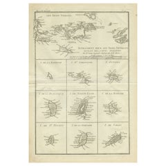
Original Antique Map of the Virgin Islands with Insets of Caribbean Isles, 1787
Located in Langweer, NL
Antique map titled 'Supplément pour les Isles Antilles (..)'. Original old map of the Virgin Islands, with insets of Barbuda, St. Kits, Antigua, Dominica, St. Lucia, Barbados, St. Vi...
Category
Antique Late 18th Century Maps
Materials
Paper
$249 Sale Price
20% Off
Free Shipping
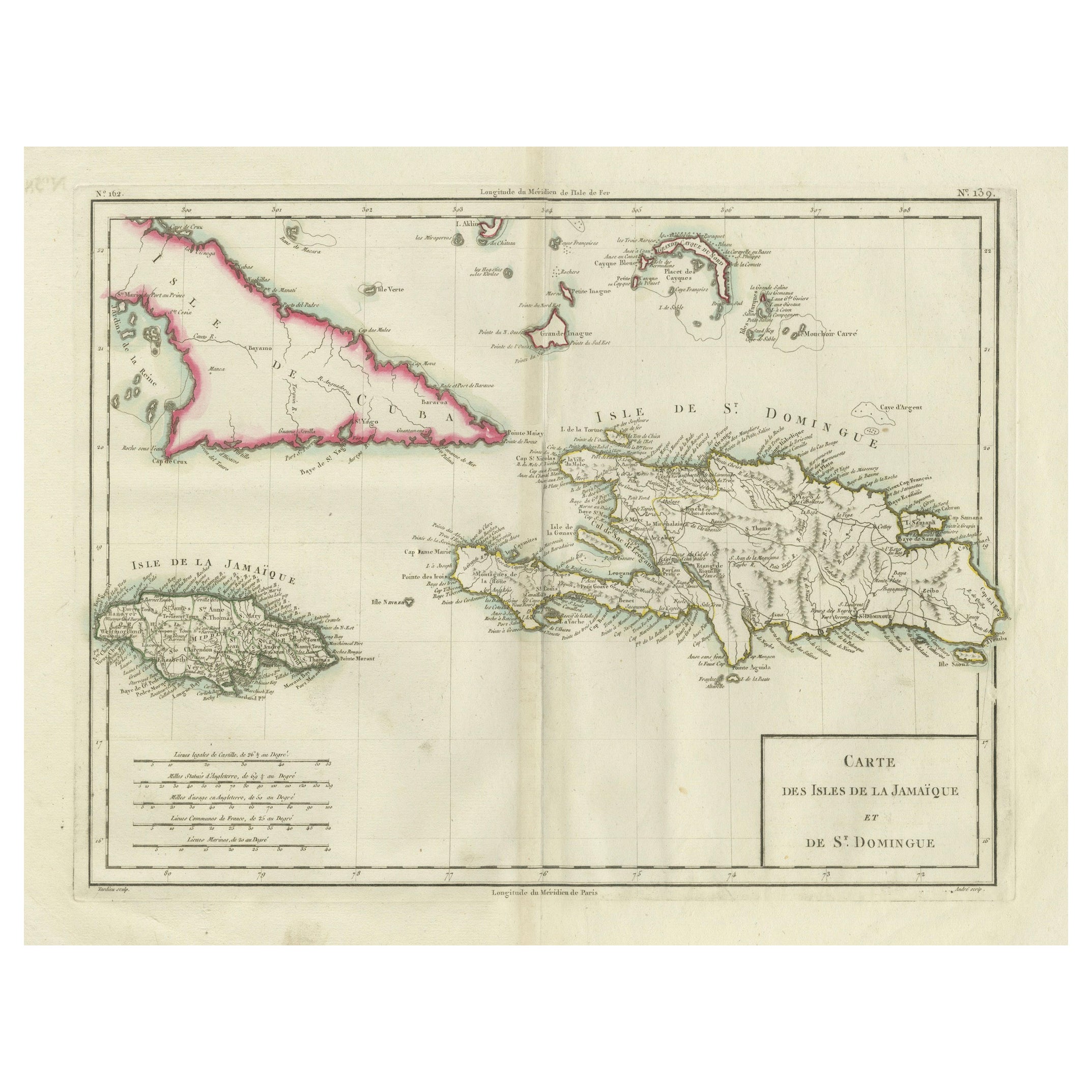
Antique Map of Jamaica and Hispaniola (Saint-Domingue and Santo Domingo), 1802
Located in Langweer, NL
This is an original antique map titled "Carte des Isles de la Jamaïque et de St. Domingue," depicting the islands of Jamaica and Saint-Domingue (modern-day Haiti and the Dominican Re...
Category
Antique Early 1800s Maps
Materials
Paper

$536 Sale Price
20% Off
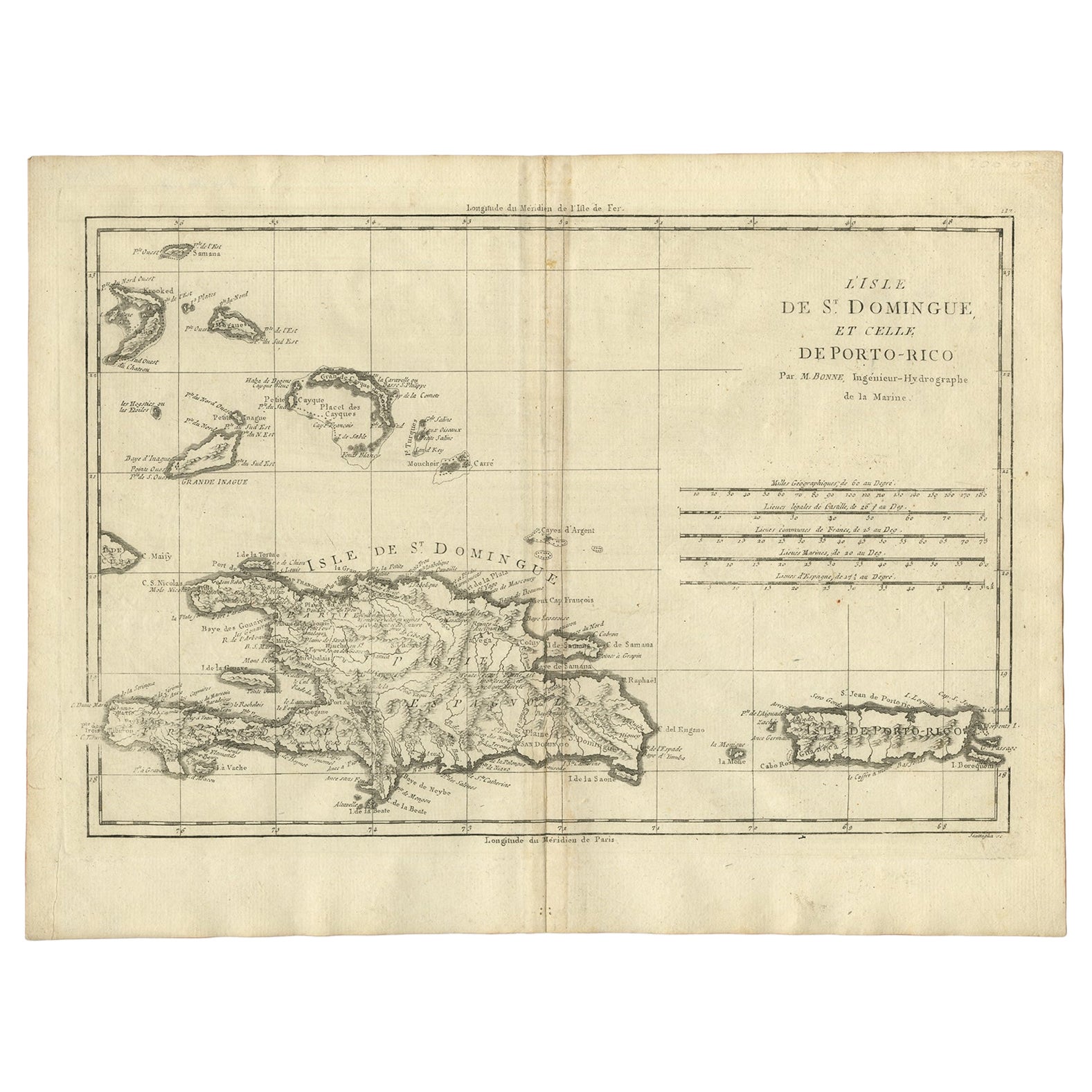
Detailed Antique Map of Santa Domingo, Puerto Rico, Eastern Bahamas, ca. 1780
Located in Langweer, NL
Description: Antique map titled 'L'Isle De St. Domingue, et celle De Porto-Rico.'
Detailed map of Santa Domingo, Puerto Rico, etc. Includes substanti...
Category
Antique 1780s Maps
Materials
Paper
$670 Sale Price
20% Off
You May Also Like
St. Christophe 'St. Kitts' Island: An 18th Century Hand-colored Map by Bellin
By Jacques-Nicolas Bellin
Located in Alamo, CA
Jacques Bellin's copper-plate map of the Caribbean island of Saint Kitts entitled "Carte De De l'Isle St. Christophe Pour servir á l'Histoire Genle. des V...
Category
Antique Mid-18th Century French Maps
Materials
Paper

Large Original Antique Map of The West Indies by Sidney Hall, 1847
Located in St Annes, Lancashire
Great map of The West Indies
Drawn and engraved by Sidney Hall
Steel engraving
Original colour outline
Published by A & C Black. 1847
Unframed
Free shipping.
Category
Antique 1840s Scottish Maps
Materials
Paper

Large Original Antique Map of the The Windward Islands. 1894
Located in St Annes, Lancashire
Superb Antique map of The Windward Islands
Published Edward Stanford, Charing Cross, London 1894
Original colour
Good condition
Unframed.
Free shipping
Category
Antique 1890s English Maps
Materials
Paper

Early 19th Century Hand Colored Map of the United States and Caribbean Islands
Located in Hamilton, Ontario
Hand coloured early 19th century map by Giraldon of France titled "Etats Unis et Grandes Antilles" (United States and Greater Antilles).
Category
Antique Early 19th Century French Maps
Materials
Paper

$595 Sale Price
40% Off
Large Original Antique Map of The Leeward Islands. 1894
Located in St Annes, Lancashire
Superb Antique map of The Leeward Islands
Published Edward Stanford, Charing Cross, London 1894
Original colour
Good condition
Unframed.
Free shipping
Category
Antique 1890s English Maps
Materials
Paper

Map Colonies Francaises Martinique, 1845
Located in BUNGAY, SUFFOLK
Colonies Francaises, Martinique, Amerique DU SUD
Geographie et Statistique par V.Levasseur. Ing'r Geographe.
Illustre par Raymond Bonheur, peintre.
Grave par Laguihermie, Rue St...
Category
Antique 19th Century French Maps
Materials
Paper

More Ways To Browse
Used Furniture Puerto Rico
Scottish Regency
Caribbean Regency
Vintage Art Deco Rugs
Vintage Serving Forks
Herati Rug
Italian Wood Console Tables
Maison Jansen Argentina
Antique Oushak
Mid Century Danish Directors Chairs
Moller 70
Wood Relief Art
Argentina Travel Poster
Century Furniture Faux Bamboo
Early American Chairs
Hans Muller
Vintage Wood Table With Glass Top
19th Century Square Table