Items Similar to 1858 Map of the Baltic States & Inner Russia to Moscow – Justus Perthes


Want more images or videos?
Request additional images or videos from the seller
1 of 10
1858 Map of the Baltic States & Inner Russia to Moscow – Justus Perthes
$519.66
£391.23
€440
CA$715.87
A$801.73
CHF 418.33
MX$9,792.81
NOK 5,322.38
SEK 5,016.98
DKK 3,349.34
About the Item
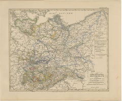
1858 Map of the Baltic States & Inner Russia to Moscow – Justus Perthes
Description:
Antique map titled "Ostsee-Länder und das Innere Russland bis Moskau," published by Justus Perthes in Gotha in 1858. This finely detailed copperplate engraving presents a comprehensive view of the Baltic region and western Russia, stretching from the shores of the Baltic Sea across to Moscow.
The map features the historical Baltic provinces—Estonia (Esthland), Latvia (Livland and Kurland), and Lithuania (Litauen)—alongside surrounding regions such as Poland, Belarus, Smolensk, and St. Petersburg. The inset at lower right provides an enlarged view of St. Petersburg and its surroundings, highlighting key rivers, roads, and defensive structures.
Political borders are hand-colored to distinguish various imperial and provincial divisions within the Russian Empire. Cities such as Riga, Vilnius, Minsk, Warsaw, and Moscow are prominently marked, along with roads, rivers, and rail connections. The coastline of the Baltic Sea (Ostsee) is finely engraved, as are parts of Finland and Sweden visible in the northwestern corner.
This map offers rich historical insight into a region deeply shaped by imperial expansion, shifting boundaries, and diverse ethnic identities in the 19th century. It is especially relevant for those interested in Russian imperial cartography, Baltic history, or geopolitical studies of Eastern Europe.
Condition report:
Very good condition. Slight age toning to margins. No tears or repairs. Original hand-coloring is clear and well-preserved. Please examine the image for details.
Framing suggestions:
Ideal in a black or deep mahogany wood frame with a pale ivory or grey mat. A thin red or blue accent line in the mat can emphasize the border colors. Suitable for display in a library, study, or historical setting.
Technique: Copperplate engraving with original hand-coloring
Maker: Justus Perthes, Gotha, 1858
- Dimensions:Height: 14.77 in (37.5 cm)Width: 17.88 in (45.4 cm)Depth: 0.01 in (0.2 mm)
- Materials and Techniques:Paper,Engraved
- Place of Origin:
- Period:
- Date of Manufacture:1858
- Condition:Very good condition. Slight age toning to margins. No tears or repairs. Original hand-coloring is clear and well-preserved. Please examine the image for details.
- Seller Location:Langweer, NL
- Reference Number:Seller: BG-05552-401stDibs: LU3054346118622
About the Seller
5.0
Recognized Seller
These prestigious sellers are industry leaders and represent the highest echelon for item quality and design.
Platinum Seller
Premium sellers with a 4.7+ rating and 24-hour response times
Established in 2009
1stDibs seller since 2017
2,531 sales on 1stDibs
Typical response time: <1 hour
- ShippingRetrieving quote...Shipping from: Langweer, Netherlands
- Return Policy
Authenticity Guarantee
In the unlikely event there’s an issue with an item’s authenticity, contact us within 1 year for a full refund. DetailsMoney-Back Guarantee
If your item is not as described, is damaged in transit, or does not arrive, contact us within 7 days for a full refund. Details24-Hour Cancellation
You have a 24-hour grace period in which to reconsider your purchase, with no questions asked.Vetted Professional Sellers
Our world-class sellers must adhere to strict standards for service and quality, maintaining the integrity of our listings.Price-Match Guarantee
If you find that a seller listed the same item for a lower price elsewhere, we’ll match it.Trusted Global Delivery
Our best-in-class carrier network provides specialized shipping options worldwide, including custom delivery.More From This Seller
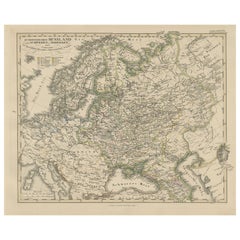
View All1857 Engraved Map of Russia, Finland & Scandinavia – Historic Print
Located in Langweer, NL
Antique Map of European Russia Including Scandinavia – Stieler Atlas 1857
This antique map titled "Europäisches Russland nebst Schweden und Norwegen" (European Russia together with ...
Category
Antique Mid-19th Century German Maps
Materials
Paper
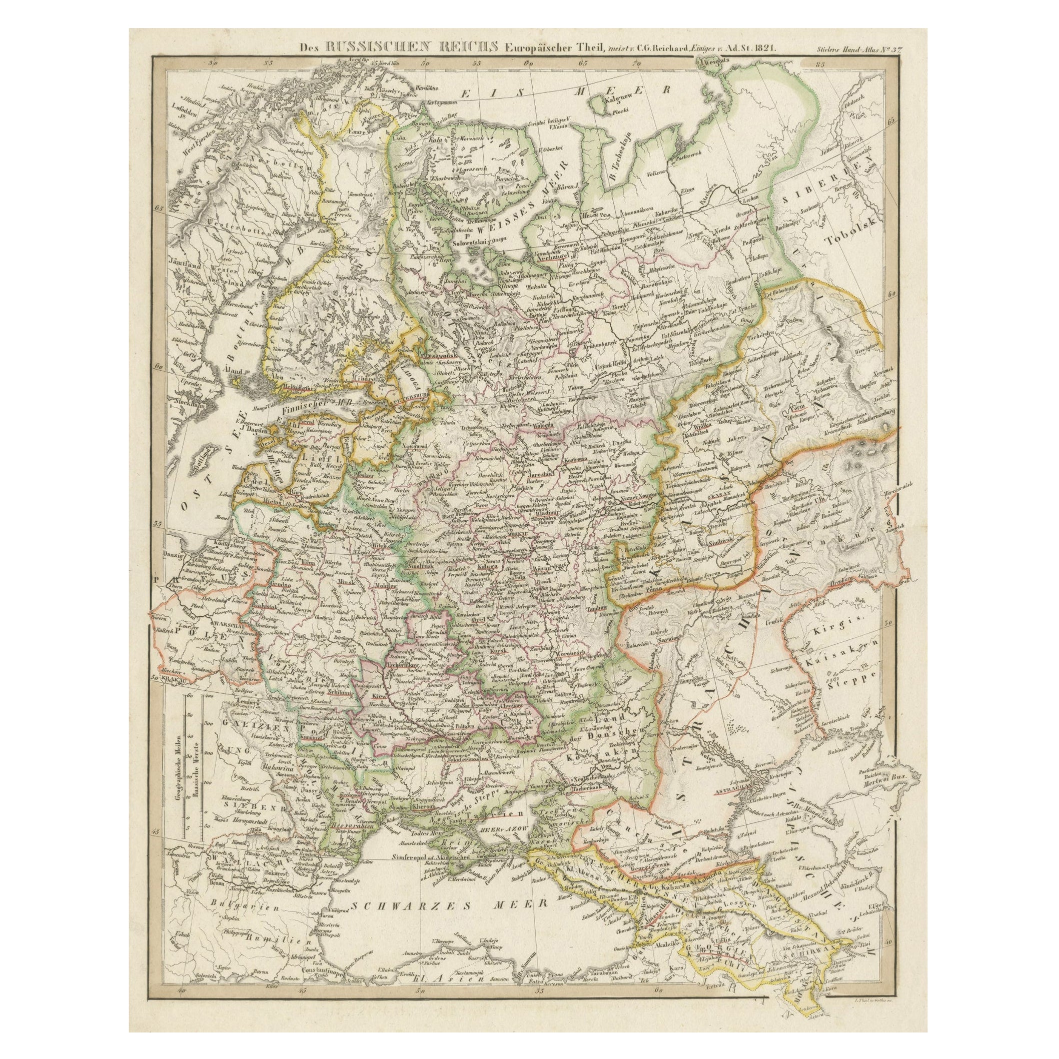
Original Antique German Map of the Russian Empire in Europe, ca.1825
Located in Langweer, NL
Antique map titled 'Des Russischen Reichs - Europäische Theil'.
Original antique map of the Russian Empire in Europe. This map originates from 'Stielers Handatlas'. Published circa...
Category
Antique 1820s Maps
Materials
Paper
$170 Sale Price
20% Off
Antique Map of Russia in Europe, 1842
Located in Langweer, NL
Antique map titled 'Carte de la Russie d'Europe'. Map of Russia in Europe. This map originates from 'Atlas universel de géographie ancienne et moderne (....
Category
Antique 19th Century Maps
Materials
Paper

$225 Sale Price
20% Off
Antique Map of Russia in Europe by Levasseur, '1875'
Located in Langweer, NL
Antique map titled 'Carte générale de la Russie d'Europe (..)'. Large map of Russia in Europe. This map originates from 'Atlas de Géographie Moderne Physique et Politique' by A. Leva...
Category
Antique Late 19th Century Maps
Materials
Paper

$330 Sale Price
20% Off
Antique Map of Russia by Tyrer, 1821
Located in Langweer, NL
Antique map titled 'Russia'. Beautiful antique map of Russia engraved by Tyrer. Artists and Engravers: Published by J. Souter, London.
Artist...
Category
Antique 19th Century Maps
Materials
Paper

$108 Sale Price
20% Off
Antique Map of Northeastern Germany – Saxon & Prussian States, 1858
Located in Langweer, NL
Antique Map of Northeastern Germany – Saxon & Prussian States, 1858
Detailed and finely engraved map titled "Nord-Östliches Deutschland enthaltend die Sächsischen Länder und die Pre...
Category
Antique Mid-19th Century German Maps
Materials
Paper
You May Also Like
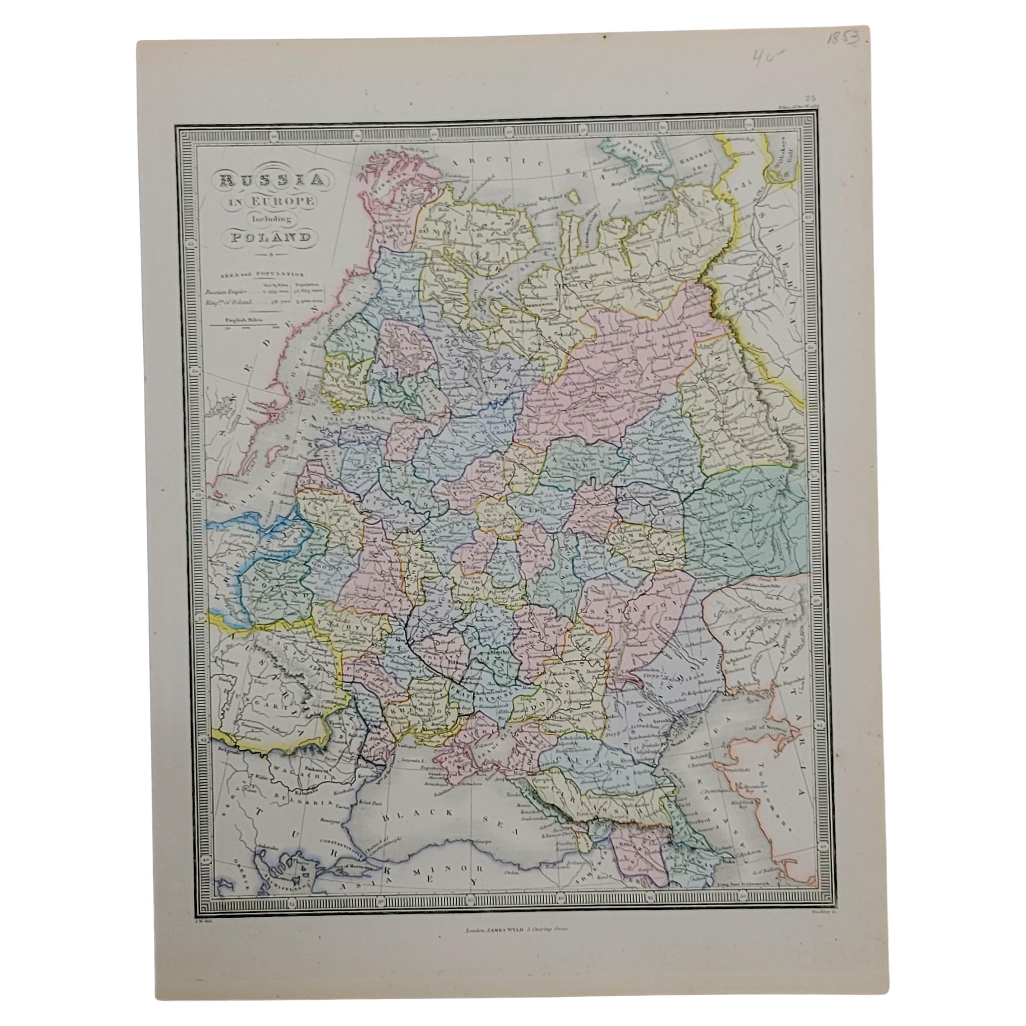
1853 Map of "Russia in Europe Including Poland" Ric.r016
Located in Norton, MA
Description
Russia in Europe incl. Poland by J Wyld c.1853
Hand coloured steel engraving
Dimension: Paper: 25 cm W x 33 cm H ; Sight: 22 cm W x 28 cm H
Condition: Good ...
Category
Antique 19th Century Unknown Maps
Materials
Paper

Russia in Europe with Poland and Finland. Century Atlas antique vintage map
Located in Melbourne, Victoria
'The Century Atlas. Russia in Europe with Poland and Finland'
Original antique map, 1903.
Central fold as issued. Map name and number printed on the reverse corners.
Sheet 40cm by ...
Category
Early 20th Century Victorian More Prints
Materials
Lithograph

Russia, Western and Southern Part. Century Atlas antique vintage map
Located in Melbourne, Victoria
'The Century Atlas. Russia, Western and Southern Part'
Original antique map, 1903.
Inset map tilted 'St Petersburg and Environs'.
Central fold as issued. Map name and number printe...
Category
Early 20th Century Victorian More Prints
Materials
Lithograph

1832 Large Map "Russian & Poland" Ric. R0012
Located in Norton, MA
Large map 1832
"Russian & Poland"
Ric.r0012
Russia & Poland, by J. Arrowsmith. London, pubd. 15 Feby. 1832 by J. Arrowsmith, 35 Essex Street, Strand., ...
Category
Antique 19th Century Unknown Maps
Materials
Paper

1849 Map of "Europaische Russland", 'Meyer Map of European Russia', Ric. R017
Located in Norton, MA
1849 Map of
"Europaische Russland"
( Meyer Map of European Russia)
Ric.r017
A lovely map of European Russia dating to 1849 by Joseph Meyer. It covers the European portions of...
Category
Antique 19th Century Unknown Maps
Materials
Paper

German Empire, Northern Part. Century Atlas antique vintage map
Located in Melbourne, Victoria
'The Century Atlas. German Empire, Northern Part.'
Original antique map, 1903.
Central fold as issued. Map name and number printed on the reverse corne...
Category
Early 20th Century Victorian More Prints
Materials
Lithograph
