Items Similar to 1864 Johnson's Map of New York State with City Insets


Want more images or videos?
Request additional images or videos from the seller
1 of 6
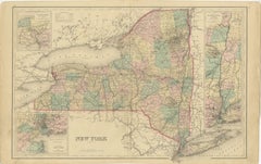
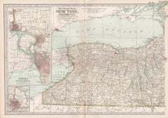
1864 Johnson's Map of New York State with City Insets
$268.22
$335.2720% Off
£198.27
£247.8420% Off
€224
€28020% Off
CA$364.79
CA$455.9920% Off
A$408.75
A$510.9420% Off
CHF 212.77
CHF 265.9620% Off
MX$5,000.42
MX$6,250.5220% Off
NOK 2,700.71
NOK 3,375.8920% Off
SEK 2,550.79
SEK 3,188.4920% Off
DKK 1,705.65
DKK 2,132.0620% Off
Shipping
Retrieving quote...The 1stDibs Promise:
Authenticity Guarantee,
Money-Back Guarantee,
24-Hour Cancellation
About the Item
Title: 1864 Johnson's Map of New York State with City Insets
Description: This 1864 map, titled "Johnson's New York," was published by Johnson and Ward and features a detailed depiction of New York State during the mid-19th century. The map is intricately colored to distinguish between counties, with bold boundary lines and clear labels for towns and major geographic features. Notably, it includes inset maps of key cities, such as Albany, Troy, Buffalo, Rochester, Syracuse, and Oswego, providing a glimpse into their layouts during this era.
This map is interesting because it not only represents the state's counties and infrastructure, such as railroads and roads, but also offers detailed views of several major urban areas. The insets are particularly valuable for understanding the development of these cities at a time when the state was rapidly growing in population and industry.
Condition:
The map is in good condition, with minor yellowing along the edges that is typical for its age. There is a central fold that indicates it was originally part of an atlas, and the elaborate decorative border remains intact. The colors are still vivid, enhancing the clarity of both the county boundaries and city insets, contributing to the overall visual appeal of the map.
- Dimensions:Height: 17.13 in (43.5 cm)Width: 26.78 in (68 cm)Depth: 0 in (0.02 mm)
- Materials and Techniques:
- Period:
- Date of Manufacture:1864
- Condition:Good condition, considering age, with some yellowing that is typical of maps from this period. Some soiling and small tears along the edges, due to handling. Study the images carefully.
- Seller Location:Langweer, NL
- Reference Number:Seller: BG-13952-31stDibs: LU3054342419372
About the Seller
5.0
Recognized Seller
These prestigious sellers are industry leaders and represent the highest echelon for item quality and design.
Platinum Seller
Premium sellers with a 4.7+ rating and 24-hour response times
Established in 2009
1stDibs seller since 2017
2,493 sales on 1stDibs
Typical response time: <1 hour
- ShippingRetrieving quote...Shipping from: Langweer, Netherlands
- Return Policy
Authenticity Guarantee
In the unlikely event there’s an issue with an item’s authenticity, contact us within 1 year for a full refund. DetailsMoney-Back Guarantee
If your item is not as described, is damaged in transit, or does not arrive, contact us within 7 days for a full refund. Details24-Hour Cancellation
You have a 24-hour grace period in which to reconsider your purchase, with no questions asked.Vetted Professional Sellers
Our world-class sellers must adhere to strict standards for service and quality, maintaining the integrity of our listings.Price-Match Guarantee
If you find that a seller listed the same item for a lower price elsewhere, we’ll match it.Trusted Global Delivery
Our best-in-class carrier network provides specialized shipping options worldwide, including custom delivery.More From This Seller
View All1862 Johnson's Map of New York State by Johnson & Browning
Located in Langweer, NL
Title: 1862 Johnson's Map of New York State by Johnson & Browning
Description:This is an 1862 map of New York State, titled "Johnson's New York," created by Johnson & Browning. The ...
Category
Antique 1860s Maps
Materials
Paper

$268 Sale Price
20% Off
1876 Antique Map of New York State with Niagara and Hudson River Insets
Located in Langweer, NL
Title: Detailed Map of New York State - 1876 by Samuel Augustus Mitchell Jr.
Description: This is a hand-colored map of the state of New York from 1876, created by Samuel Augustus ...
Category
Antique 1870s Maps
Materials
Paper
$210 Sale Price
20% Off
Antique Map of New York by Johnson '1872'
Located in Langweer, NL
Antique map titled 'Johnson's New York'. Original map showing New York, with an inset map of Long Island. This map originates from 'Johnson's New Il...
Category
Antique Late 19th Century Maps
Materials
Paper

$239 Sale Price
20% Off
Large Antique Map of New York State with Inset Maps
Located in Langweer, NL
Antique map titled 'Johnson's New York' Large map of New York State. With insets of Albany, Oswego, Buffalo, Rochester, Syracuse, Troy and NYC. Published by Johnson and Browning, 186...
Category
Antique Mid-19th Century Maps
Materials
Paper

$469 Sale Price
20% Off
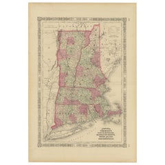
Rare 1864 Civil War Era Map of Vermont, New Hampshire, and Southern New England
Located in Langweer, NL
Title: Rare 1864 Civil War Era Map of Vermont, New Hampshire, and Southern New England
Description: This finely detailed antique map, titled "Johnson's Vermont, New Hampshire, Massa...
Category
Antique 1860s Maps
Materials
Paper
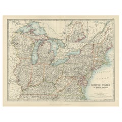
Antique Map of the Northeast USA - Vibrant 1903 Cartographic Detail
Located in Langweer, NL
Map of the Northeastern United States of North America, 1903
This striking antique map titled “United States of North America (North Eastern Sheet)” was created by the renowned Scot...
Category
Early 20th Century Maps
Materials
Paper
You May Also Like
1858 Colton's Map of New York, Ric.B011
Located in Norton, MA
An 1858 Colton's map of New York
Ric.b011
Colton’s New York, 1858 - A large original color engraved and very detailed map of the state of New York,...
Category
Antique 19th Century Unknown Maps
Materials
Paper

Original Antique Map of the American State of New York ( Western Part ) 1903
Located in St Annes, Lancashire
Antique map of New York ( Western Part )
Published By A & C Black. 1903
Original colour
Good condition
Unframed.
Free shipping
Category
Antique Early 1900s English Maps
Materials
Paper

Original Antique Map of the American State of New York ( Northern Part ) 1903
Located in St Annes, Lancashire
Antique map of New York ( Northern Part )
Published By A & C Black. 1903
Original colour
Good condition
Unframed.
Free shipping
Category
Antique Early 1900s English Maps
Materials
Paper

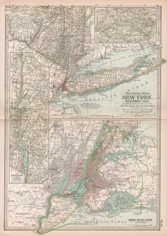
New York. Southern Part. USA. Century Atlas state antique vintage map
Located in Melbourne, Victoria
'The Century Atlas. New York. Southern Part.'
Original antique map, 1903.
Inset maps of 'New York City and Vicinity' and 'The Hudson'.
Central fold as issued. Map name and number p...
Category
Early 20th Century Victorian More Prints
Materials
Lithograph
New York, Western Part. USA. Century Atlas state antique vintage map
Located in Melbourne, Victoria
'The Century Atlas. New York, Western Part'
Original antique map, 1903.
Central fold as issued. Map name and number printed on the reverse corners.
Sheet 29.5cm by 40cm.
Category
Early 20th Century Victorian More Prints
Materials
Lithograph
Original Antique Map of the American State of New York ( Southern Part ) 1903
Located in St Annes, Lancashire
Antique map of New York ( Southern Part )
Published By A & C Black. 1903
Original colour
Good condition
Unframed.
Free shipping
Category
Antique Early 1900s English Maps
Materials
Paper

More Ways To Browse
Used Furniture Albany
Elios Chair
Plata Lappas
Red Retro Dining Set
Antique Bouquet
Antique Silver Glasses Case
Carlo Scarpa 1934 Chairs
Christofle Marly
1900 Antique Chairs
Glass Table Italian Round
Mid Century Colonial
Alvar Aalto Poster
Geometric Metal Table
Post Modern High Chairs
United Nations
Vintage Vine Rug
Cancel An Order
Antique Framing Square