Items Similar to 1874 Map of Western United States – Detailed Atlas by Keith Johnston


Video Loading
Want more images or videos?
Request additional images or videos from the seller
1 of 11
1874 Map of Western United States – Detailed Atlas by Keith Johnston
$639.42
£484.37
€549
CA$885.82
A$993.51
CHF 520.29
MX$12,072.13
NOK 6,606.76
SEK 6,263.68
DKK 4,179.96
About the Item
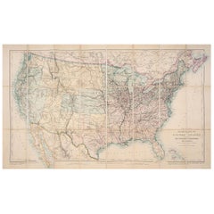
1874 Map of Western United States by Keith Johnston – Detailed Atlas
This is an original antique map titled “United States of North America (Western States)” by Alexander Keith Johnston, published in Edinburgh in 1874 as part of Keith Johnston’s General Atlas. The map presents a highly detailed view of the western half of the United States during a period of rapid territorial expansion and development.
The engraving covers the region from the Mississippi River westward to the Pacific coast, including states such as California, Oregon, Nevada, Utah, Arizona, New Mexico, Texas, Colorado, and parts of Kansas, Nebraska, and the Indian Territory (present-day Oklahoma). Major cities, towns, forts, and settlements are labelled, along with extensive river systems, mountain ranges, and railroad lines.
Notable features include:
* The territorial boundaries reflecting the political landscape of the late 19th century.
* Detailed depiction of topography with hachures indicating elevation, especially along the Rocky Mountains, Sierra Nevada, and Cascade Range.
* Early railway routes essential for westward expansion and economic integration.
* Indian Territory clearly labelled, illustrating pre-statehood Oklahoma.
* The large, sparsely populated areas of the Great Plains and desert Southwest before modern development.
* Lake Tulare. Tulare Lake. On the map it is labelled as “Tulare L.” located in California’s Central Valley, southwest of Visalia and north of Bakersfield. Historically, Tulare Lake was the largest freshwater lake west of the Mississippi River, fed by rivers such as the Kings, Kaweah, Tule, and Kern. It has mostly dried up due to agricultural diversion but was still prominent on 19th-century maps like this.
The map is printed in fine steel engraving with original outline colour highlighting state and territorial borders. Alexander Keith Johnston (1804–1871) was a leading Scottish cartographer known for his precise and elegant maps, and his atlases remain prized for their clarity and accuracy.
Condition:
Very good condition. Strong clean impression with original colour. Light overall age toning and faint foxing mainly in margins. Original atlas fold line flattened for presentation. No tears or repairs noted. Fully suitable for framing.
Framing tips:
Frame this map in a slim black, walnut, or antique gold frame to enhance its historic and geographical appeal. Use an off-white or cream archival mat to protect edges and highlight fine details. UV-protective glazing is recommended to maintain paper integrity and prevent fading.
- Dimensions:Height: 19.38 in (49.2 cm)Width: 24.41 in (62 cm)Depth: 0.01 in (0.2 mm)
- Materials and Techniques:
- Place of Origin:
- Period:
- Date of Manufacture:1874
- Condition:Very good condition. Strong clean impression with original colour. Light overall age toning and faint foxing mainly in margins. Original atlas fold line flattened for presentation. No tears or repairs noted. Fully suitable for framing.
- Seller Location:Langweer, NL
- Reference Number:Seller: BG-13601-1-11stDibs: LU3054345712572
About the Seller
5.0
Recognized Seller
These prestigious sellers are industry leaders and represent the highest echelon for item quality and design.
Platinum Seller
Premium sellers with a 4.7+ rating and 24-hour response times
Established in 2009
1stDibs seller since 2017
2,516 sales on 1stDibs
Typical response time: <1 hour
- ShippingRetrieving quote...Shipping from: Langweer, Netherlands
- Return Policy
Authenticity Guarantee
In the unlikely event there’s an issue with an item’s authenticity, contact us within 1 year for a full refund. DetailsMoney-Back Guarantee
If your item is not as described, is damaged in transit, or does not arrive, contact us within 7 days for a full refund. Details24-Hour Cancellation
You have a 24-hour grace period in which to reconsider your purchase, with no questions asked.Vetted Professional Sellers
Our world-class sellers must adhere to strict standards for service and quality, maintaining the integrity of our listings.Price-Match Guarantee
If you find that a seller listed the same item for a lower price elsewhere, we’ll match it.Trusted Global Delivery
Our best-in-class carrier network provides specialized shipping options worldwide, including custom delivery.More From This Seller
View All1874 Map of the United States with Territorial Boundaries
Located in Langweer, NL
Title: 1874 Map of the United States with Territorial Boundaries
Description: This is an 1874 map titled "Map of the United States," showcasing the country during a period of rapid ...
Category
Antique 1870s Maps
Materials
Paper
$242 Sale Price
20% Off
Map of Western United States 1903 – Railroads, State Borders, and Terrain
Located in Langweer, NL
Map of Western United States 1903 – Railroads, State Borders, and Terrain
This beautifully engraved map titled "United States of North America (Western Sheet)" was created by Keith ...
Category
Early 20th Century Maps
Materials
Paper

Antique Map of the United States by Titus '1871'
Located in Langweer, NL
Antique map titled 'The United States of America'. Original antique map of the United States. This map originates from 'Atlas of Prebl...
Category
Antique Late 19th Century Maps
Materials
Paper

$745 Sale Price
20% Off
1876 Map of the United States: Detailing the Railroads and Unsettled Territories
Located in Langweer, NL
Stanford’s Smaller Railway Map of the United States, 1876
This original 1876 map, titled "Stanford's Smaller Railway Map of the United States Distinguishing the Unsettled Territorie...
Category
Antique 1870s Maps
Materials
Paper
Antique Map of the United States of North America, c.1882
Located in Langweer, NL
Antique map titled 'United States of North America'. Old map of the United States of North America. This map originates from 'The Royal Atlas of Modern Geography, Exhibiting, in a Se...
Category
Antique 1880s Maps
Materials
Paper

$326 Sale Price
20% Off
Antique Railroad Map of the United States by Rand, McNally & Co, 1900
Located in Langweer, NL
Antique map titled 'Rand, McNally & Co's New Official Railroad map of the United States with portions of The Dominion of Canada, The Republic of Mexico and the West Indies'. Large railroad map of the United States, sectionalised and laid on linen. Map shows state boundaries for the United States, Mexico, the West Indies, and lower portion of Canada; major cities and towns, military posts, Native American reservations, and railroads; Oklahoma and "Indian Territory." Inset: "Map of Alaska...
Category
20th Century Maps
Materials
Linen, Paper

$2,183 Sale Price
25% Off
Free Shipping
You May Also Like
Original Antique Map of The United States of America by Dower, circa 1835
Located in St Annes, Lancashire
Nice map of the USA
Drawn and engraved by J.Dower
Published by Orr & Smith. C.1835
Unframed.
Free shipping
Category
Antique 1830s English Maps
Materials
Paper

Original Antique Map of United States, Grattan and Gilbert, 1843
Located in St Annes, Lancashire
Great map of United States
Drawn and engraved by Archer
Published by Grattan and Gilbert. 1843
Original colour
Unframed.
Category
Antique 1840s English Maps
Materials
Paper

North America. Century Atlas antique vintage map
Located in Melbourne, Victoria
'The Century Atlas. North America'
Original antique map, 1903.
Central fold as issued. Map name and number printed on the reverse corners.
Sheet 40cm by 29.5cm.
Category
Early 20th Century Victorian More Prints
Materials
Lithograph

Large Original Antique Map of the United States of America. 1891
By Rand McNally & Co.
Located in St Annes, Lancashire
Fabulous map of The United States
Original color
By Rand, McNally & Co.
Dated 1891
Unframed
Free shipping.
Category
Antique 1890s American Maps
Materials
Paper

Manitoba, British Columbia and NW Territories, Canada. Century Atlas antique map
Located in Melbourne, Victoria
'The Century Atlas. Manitoba, British Columbia and the Northwest Territories, Canada, North America.'
Original antique map, 1903.
Central fold as issued. Map name and number printe...
Category
Early 20th Century Victorian More Prints
Materials
Lithograph

California, Northern Part. USA Century Atlas state antique vintage map
Located in Melbourne, Victoria
'The Century Atlas. California, Northern Part'
Inset maps of 'Yosemite Valley' and 'San Francisco and Vicinity'.
Original antique map, 1903.
Central fold as issued. Map name and nu...
Category
Early 20th Century Victorian More Prints
Materials
Lithograph
More Ways To Browse
Furniture Kansas City
Used Furniture Oklahoma City
Antique Furniture Oklahoma
Railway Map
Scottish Walnut
L Kern
Curved Velvet Couch
Velvet Curved Sofa
Wood Round Coffee Tables
Oak Brutalist
Used College Furniture
Wood Minimalist Chair
Antique Imperial Furniture
Gold Modern Coffee Table
Large Side Tables
18th Century Gilded Furniture
Fluted Column
Japanese Silver Ceramics