Items Similar to 18th Century Map of French Pyrenees Region of France


Video Loading
Want more images or videos?
Request additional images or videos from the seller
1 of 22
18th Century Map of French Pyrenees Region of France
$475
£364.03
€418.39
CA$667.16
A$746.68
CHF 390.86
MX$9,070.76
NOK 4,962.91
SEK 4,683.35
DKK 3,121.91
About the Item
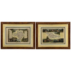
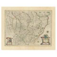
An antique map titled "Principatus Benearnia, La Principaute De Bearn" created by the renowned Dutch cartographer Willem Janszoon Blaeu.
It depicts the Principality of Bearn, a historical region located in the present-day Pyrénées-Atlantiques department in southwestern France. The Latin "Principatus Benearnia" translates to "The Principality of Bearn". This original map was first issued in 1631 and was later included in Willem Blaeu's seminal work, the Theatrum orbis terrarum, sive Atlas novus (Theater of the World, or New Atlas), published around 1640.
The map includes a decorative title cartouche, coats of arms, and details typical of 17th-century cartography, such as mountains, rivers, cities, and villages.
Willem Janszoon Blaeu was a leading Dutch cartographer of the 17th century, known for his high-quality atlases and globes. His works, including this map, are highly regarded for their detail and artistry.
Comes custom framed in a gold framed, ready to hang.
- Dimensions:Height: 18 in (45.72 cm)Width: 23.5 in (59.69 cm)Depth: 1 in (2.54 cm)
- Style:Baroque (In the Style Of)
- Materials and Techniques:
- Place of Origin:
- Period:
- Date of Manufacture:Late 19th Century
- Condition:Wear consistent with age and use. Minor fading.
- Seller Location:Haddonfield, NJ
- Reference Number:Seller: 372231stDibs: LU943446102202
About the Seller
5.0
Platinum Seller
Premium sellers with a 4.7+ rating and 24-hour response times
Established in 2010
1stDibs seller since 2012
1,992 sales on 1stDibs
Typical response time: <1 hour
- ShippingRetrieving quote...Shipping from: Haddonfield, NJ
- Return Policy
Authenticity Guarantee
In the unlikely event there’s an issue with an item’s authenticity, contact us within 1 year for a full refund. DetailsMoney-Back Guarantee
If your item is not as described, is damaged in transit, or does not arrive, contact us within 7 days for a full refund. Details24-Hour Cancellation
You have a 24-hour grace period in which to reconsider your purchase, with no questions asked.Vetted Professional Sellers
Our world-class sellers must adhere to strict standards for service and quality, maintaining the integrity of our listings.Price-Match Guarantee
If you find that a seller listed the same item for a lower price elsewhere, we’ll match it.Trusted Global Delivery
Our best-in-class carrier network provides specialized shipping options worldwide, including custom delivery.More From This Seller
View All16th Century Antique Map of Ven Framed in Gold
Located in Haddonfield, NJ
Ven (older Swedish spelling Hven), is a Swedish island in the Öresund strait laying between Skåne, Sweden and Zealand and Denmark. The island was historically under Danish rule. Dani...
Category
Antique 16th Century Danish Baroque Maps
Materials
Wood, Paper
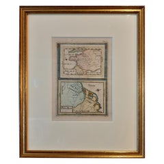
Set of Two 19th Century French Hand-Colored Regional Maps
Located in Haddonfield, NJ
These historical regional maps depict the “Dépt de la Moselle" (Department of Moselle) and the Departement de Gard in France. Both pieces date back to the 19th Century, given their s...
Category
Antique 19th Century French Empire Drawings
Materials
Wood, Paper
19th Century Reprint of 16th Century Harbor Map of Copenhagen
Located in Haddonfield, NJ
This reprint of 1587 antique map of Copenhagen, Denmark retains its original mid-century mat and has been recently reframed in classic wood frame. The muted sepia colored map is a wo...
Category
Antique 1880s Danish Baroque Maps
Materials
Wood, Paper

19th Century Lithograph Map of Lower Manhattan, New York
Located in Haddonfield, NJ
1859 hand colored map of Lower Manhattan or New Amsterdam by George H. Moore.
Category
Antique 19th Century English Folk Art Maps
Materials
Paper

$620 Sale Price
20% Off
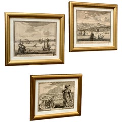
18th C. Set of 3 Etchings of Harbor Scenes in Gilt Frames
By Pieter Schenk the Elder, Pierre Mortier
Located in Haddonfield, NJ
A set of three antique Dutch engravings and etchings from the 18th Century. This set has been professionally framed in newer gilt frames and feature acid-free paper to protect these...
Category
Antique 18th Century Dutch Baroque Prints
Materials
Paper, Boxwood, Paint
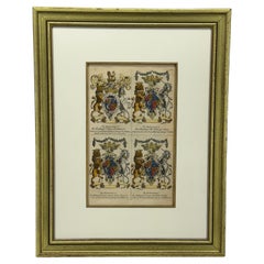
English Coat of Arms Art Print by Joseph Edmondson Gold Leaf Frame
Located in Haddonfield, NJ
The image shows a page from "Baronagium Genealogicum" by Joseph Edmondson, published in 1764. It features the coats of arms for Prince Frederick, Princess Anne, Princess Amalia Sophi...
Category
Antique Late 19th Century English Prints
Materials
Wood, Paper
You May Also Like
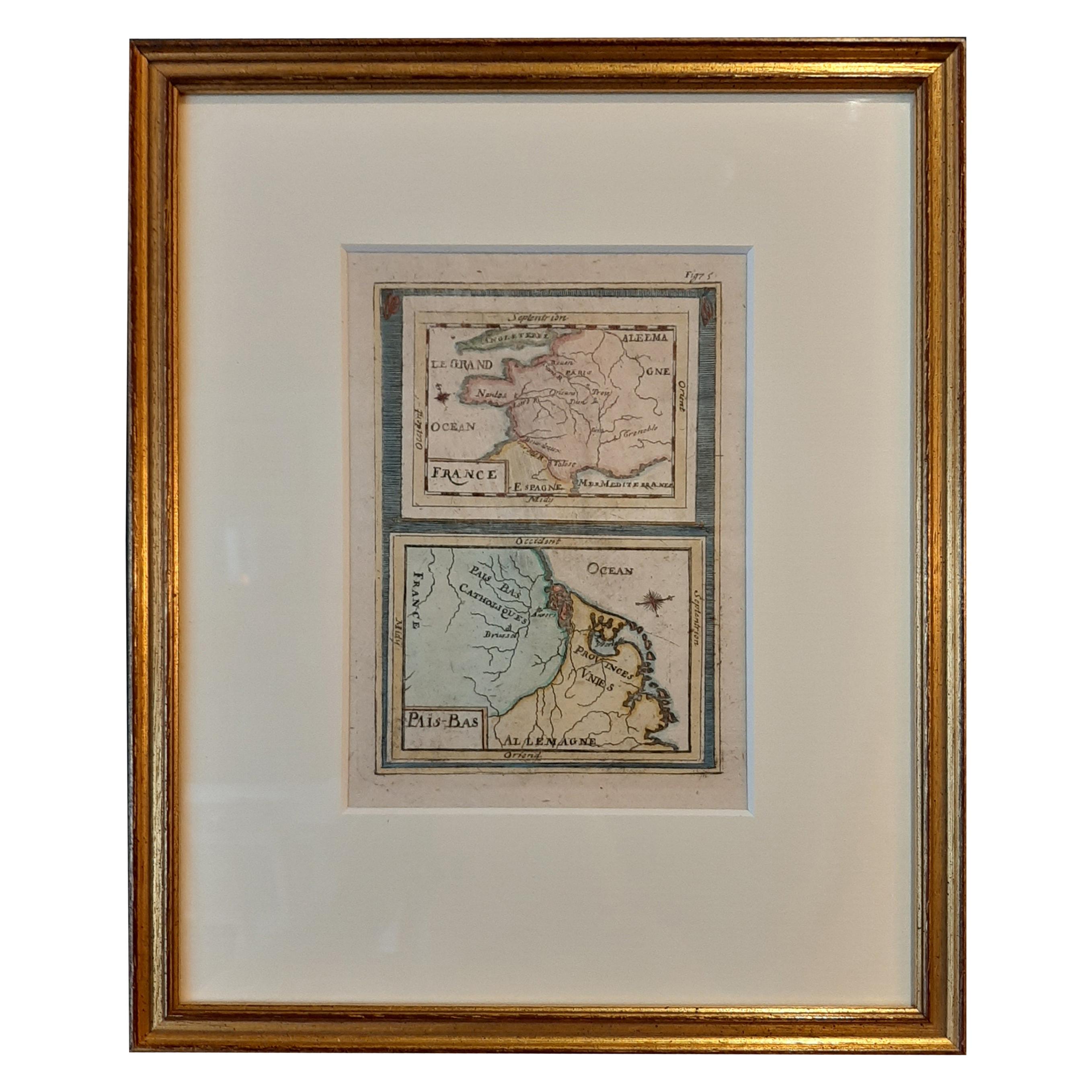
Antique Miniature Map of France and the Low Countries by Mallet, circa 1719
Located in Langweer, NL
Antique map titled 'France - Païs-Bas'. Miniature Map of France and the Low Countries. Published by A.M. Mallet, circa 1719.
Frame included. We carefully pack our framed items to ...
Category
Antique Early 18th Century Maps
Materials
Paper
$165 Sale Price
20% Off
Antique Map of the Region of Île-de-France by Hondius, circa 1630
Located in Langweer, NL
Antique map titled Gouvernement de l'Isle de France'. Old map of the region of Île-de-France, France. It is located in the north-central part of the country and often called the régi...
Category
Antique Mid-17th Century Maps
Materials
Paper

$519 Sale Price
20% Off
Framed 17th Century Map of Cumberland, England by John Speed, 1610
By John Speed
Located in Middleburg, VA
A fascinating and richly detailed antique map of Cumberland County in northwest England, drawn and published by the celebrated English cartographer John Spe...
Category
Antique Early 17th Century English British Colonial Maps
Materials
Copper, Gold Leaf

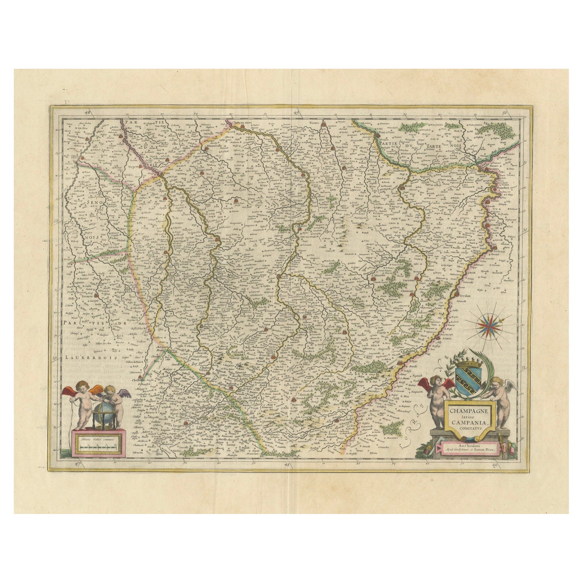
Authentic 1644 Janssonius Map of the Champagne Region (Campania) in France
Located in Langweer, NL
"1644 Janssonius Map of Champagne, France"
This meticulously detailed original antique map, engraved in 1644, is a work by the esteemed cartographer Johannes Janssonius. It depicts the historic province of Champagne, situated in the northeastern part of France. The map is notable for its high level of detail, with meticulously drawn boundaries, city markers, and river courses. It features a beautifully rendered cartouche adorned with the provincial coat of arms, flanked by classical figures, indicative of the region's cultural significance. In the lower left corner, a pair of cherubs are engaged in surveying, symbolizing the scientific endeavor of cartography. The elaborate compass rose and the scale bar further complement the map's utility and artistic merit.
Champagne is renowned globally for its viticultural heritage, being the birthplace of the eponymous Champagne sparkling wine. The region's unique terroir, with its chalky soil and cool climate, is ideal for the production of the grapes used in champagne-making. The historical significance of Champagne extends beyond winemaking; it has been the site of pivotal battles and royal coronations, which shaped the course of French and European history. This map is not only a navigational tool but also a snapshot of a region rich in history and tradition, an artifact that embodies the geographical and cultural prestige of Champagne.
This description provides a detailed visual and contextual presentation of the map, suitable for a catalog entry, emphasizing both its artistic features and the historical and cultural importance of the Champagne region.
THE WINE AREAS:
The Champagne region, known primarily for its production of the sparkling wine that bears its name, encompasses several important cities and sites of historical and cultural significance:
1. **Reims**: Often considered the unofficial capital of the Champagne region, Reims is renowned for its grand cathedral, Notre-Dame de Reims, where French kings were historically crowned...
Category
Antique 1640s Maps
Materials
Paper
$604 Sale Price
20% Off
Free Shipping
Antique Map of the Lorraine Region 'France' (c.1735)
Located in Langweer, NL
Antique map titled 'Carte du Duche de Lorraine - Kaart van Lotharingen'. A detailed map of the Duchy of Lorraine. The map is surrounded by thirteen vignette bird-eye view of fortifie...
Category
Antique Mid-18th Century Maps
Materials
Paper

$259 Sale Price
20% Off
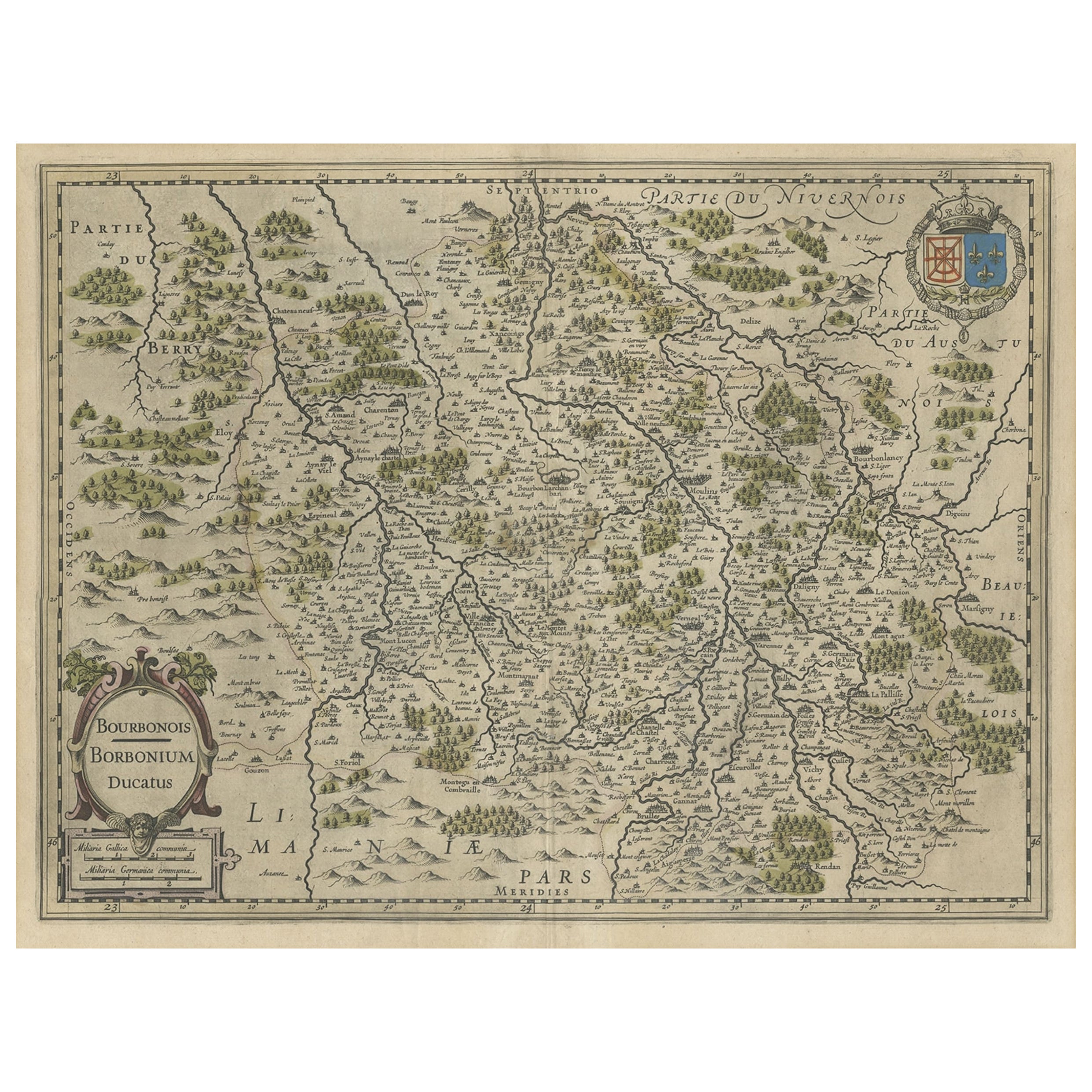
Old Map of the Bourbonnais Region of France, ca.1630
Located in Langweer, NL
Antique map titled 'Bourbonois - Borbonium Ducatus'.
Old map of the Bourbonnais region of France. Bourbonnais was a historic province in the centre of France that corresponds to ...
Category
Antique 1630s Maps
Materials
Paper
$595 Sale Price
20% Off