Items Similar to Old Map of the Bourbonnais Region of France, ca.1630


Want more images or videos?
Request additional images or videos from the seller
1 of 5
Old Map of the Bourbonnais Region of France, ca.1630
About the Item
Antique map titled 'Bourbonois - Borbonium Ducatus'.
Old map of the Bourbonnais region of France. Bourbonnais was a historic province in the centre of France that corresponds to the modern département of Allier, along with part of the département of Cher.
Artists and Engravers: Gerard Mercator (Kremer) was born in Rupelmonde in Flanders and studied in Louvain. He drawn his first map in 1537 and became a cartographer and globe maker. In 1552 he moved to Duisburg, Germany where he published his famous 18-sheet world map in 1569 with his own new projection, today called Mercator projection. Later he decided to publish a new edition of Ptolemy's Geographia. Followed by his major work, a 3 volume collection of maps to which the word "Atlas" was applied the first time. The first volume was published 1585, followed by the second in 1589 and the third one after his death in 1595 by his son Rumold. A second edition of all three parts was published 1602. 1604 Jodocus Hondius acquired the plates and published several edition together with his sons Jodocus II and Henricus until 1633. More editions followed until 1666 by Janssonius who was in partnership with Henricus. Some of the plated where also used in W.J. Blaeu in 1630.
Condition: Fair/good, age-related toning. Repair on folding line. Original/contemporary hand coloring. Latin text on verso, please study image carefully.
- Dimensions:Height: 18.12 in (46 cm)Width: 22.05 in (56 cm)Depth: 0 in (0.02 mm)
- Materials and Techniques:
- Period:1630-1639
- Date of Manufacture:circa 1630
- Condition:Repaired: Repair on folding line. Original/contemporary hand coloring. Wear consistent with age and use.
- Seller Location:Langweer, NL
- Reference Number:
About the Seller
5.0
Platinum Seller
These expertly vetted sellers are 1stDibs' most experienced sellers and are rated highest by our customers.
Established in 2009
1stDibs seller since 2017
1,929 sales on 1stDibs
Typical response time: <1 hour
- ShippingRetrieving quote...Ships From: Langweer, Netherlands
- Return PolicyA return for this item may be initiated within 14 days of delivery.
More From This SellerView All
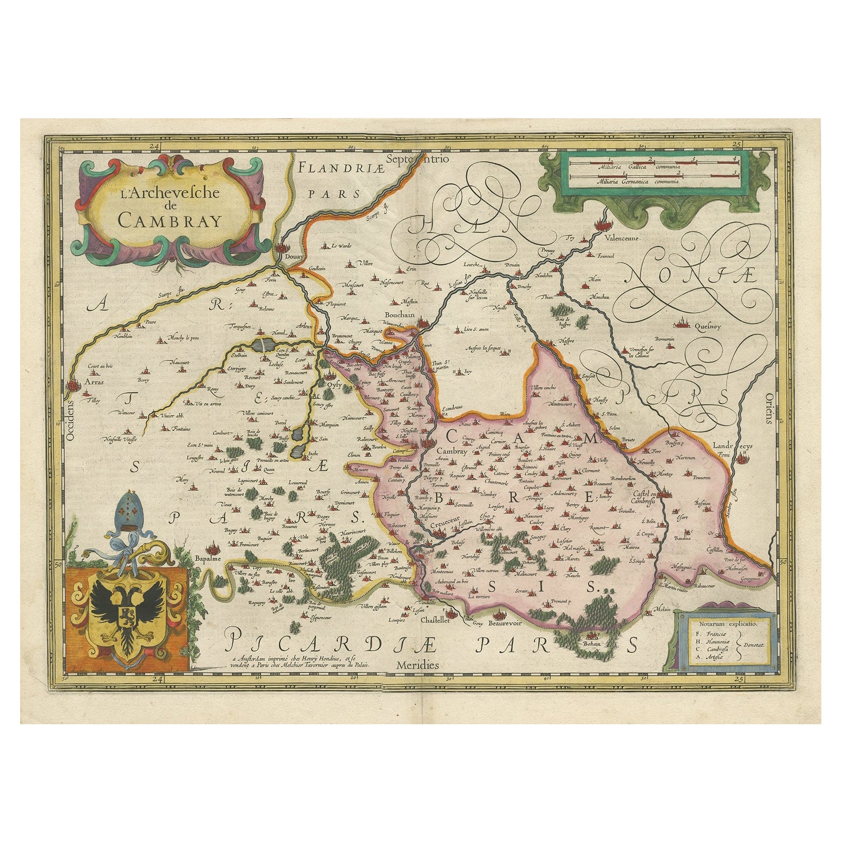
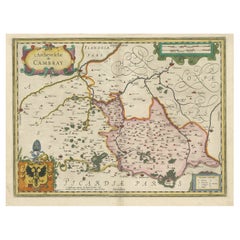
- Decorative Antique Map of the Region of Cambrai, France, ca.1630Located in Langweer, NLAntique map titled 'l'Archevesche de Cambray'. Decorative map of the region of Cambrai, France. Includes the cities of Cambrai, Valencienes, Douai, and Bouchain. Artists and Engravers: Henricus...Category
Antique 1630s Maps
MaterialsPaper
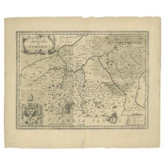
- Antique Map of the Region of Cambrai in France, c.1630Located in Langweer, NLAntique map titled 'l'Archevesche de Cambray'. Decorative map of the region of Cambrai, France. Includes the cities of Cambrai, Valencienes, Douai, and Bouchain. Artists and Engrav...Category
Antique 17th Century Maps
MaterialsPaper
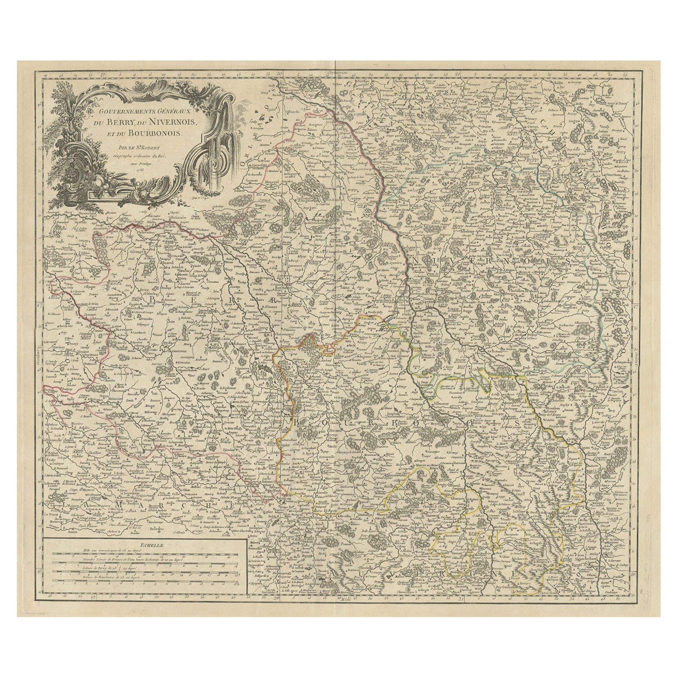
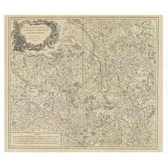
- Large Antique Map of the Region of Berry, Nivernois & Bourbonnais, France, 1753Located in Langweer, NLAntique map titled 'Gouvernements généraux du Berry, du Nivernois et du Bourbonois'. Large, original antique map of the region of Berry, Nivernois and Bourbonnais, France. Featur...Category
Antique 1750s Maps
MaterialsPaper
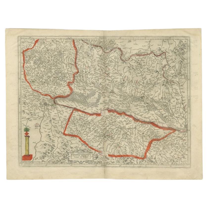
- Antique Map of the Alsace Region of France by Hondius, c.1630Located in Langweer, NLAntique map titled 'Alsatia Superior (..)'. Original antique map of the Alsace (Elzas) region of France. The map is centered on the course of the Rhine River, from Strasbourg in the north to Basle. Artists and Engravers: Published by H. Hondius. Henricus Hondius...Category
Antique 17th Century Maps
MaterialsPaper
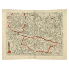
- Antique Map of the Region of Bourbonnais by Janssonius, circa 1640Located in Langweer, NLAntique map titled 'Bourbonois - Borbonium Ducatus'. Old map of the former region of Bourbonnais, France. It includes the cities of Bourbon, Moulins, Charenton, Brulles, Varennes and...Category
Antique Mid-17th Century Maps
MaterialsPaper
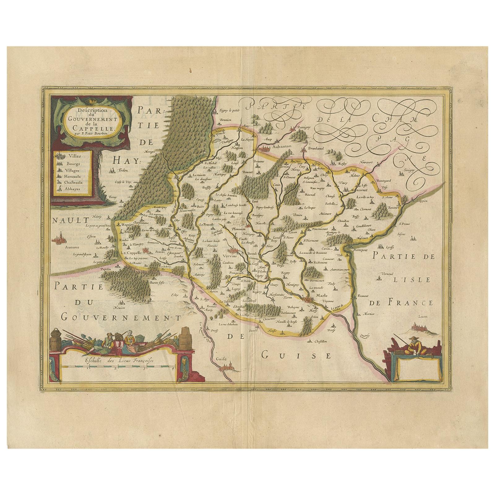
- Antique Map of the Region of Hauts-de-France by Hondius, circa 1630Located in Langweer, NLAntique map titled 'Description du Gouvernement de la Cappelle'. Old map of the region of Hauts-de-France including the cities of Vervins, Marle, Cappelle and others. This map origin...Category
Antique Mid-17th Century Maps
MaterialsPaper


You May Also Like
- 1594 Maurice Bouguereau Map of the Region Limoges, France, Ric0015Located in Norton, MA1594 Maurice Bouguereau map of the region Limoges, France, entitled "Totivs Lemovici et Confinium Pro Uinciarum Quantum ad Dioecefin Lemo Uicenfen Fpectant," Hand Colored Ric0015 Jean IV Le Clerc...Category
Antique 16th Century Dutch Maps
MaterialsPaper
- The Normandy Region of France: A 17th C. Hand-colored Map by Sanson and JaillotBy Nicolas SansonLocated in Alamo, CAThis large hand-colored map entitled "Le Duché et Gouvernement de Normandie divisée en Haute et Basse Normandie en divers Pays; et par evêchez, avec le Gouvernement General du Havre ...Category
Antique 1690s French Maps
MaterialsPaper
- 1656 Jansson Map Metz Region of France Entitled "Territorium Metense" Ric0014Located in Norton, MA1656 Jansson map Metz Region of France entitled "Territorium Metense." Ric0014 " Authentic" - Map of the historical region surrounding Metz, in Lorraine, France. Oriented with ...Category
Antique 17th Century Dutch Maps
MaterialsPaper
- Old Nautical Map of CorsicaLocated in Alessandria, PiemonteST/556/1 - Old map of Corsica isle, surveyed by Captain Hell, of the French Royal Navy in 1824, engraved and published on 1874, with additions and corre...Category
Antique Early 19th Century English Other Prints
MaterialsPaper
- Old Horizontal Map of EnglandBy TassoLocated in Alessandria, PiemonteST/520 - Old rare Italian map of England, dated 1826-1827 - by Girolamo Tasso, editor in Venise, for the atlas of M.r Le-Sage.Category
Antique Early 19th Century Italian Other Prints
MaterialsPaper
- 17th Century Topographical Map, French Champagne Region, Epernay, Iohan PeetersLocated in New York, NYFine topographical 17th century map by Iohan Peeters of the towns of Epernay and Lametz in the Champagne Region of North Eastern France. Fabulous period engraving for a Wine Cellar,...Category
Antique 17th Century Dutch Maps
MaterialsPaper


Recently Viewed
View AllMore Ways To Browse
Old French Plates
Antique Globes Of The World
Hand Drawn Map
Antique Maps And Globes
Antique Globes And Maps
World Map Globe
Old Antique Globes
Antique Map Fair
Mercator Map
Map Blaeu
Blaeu Maps
Mercator Antique
Map Hondius
Antique Map Blaeu
Antique Old World Globe
Antique World Globe Map
Chers French
Historic Antique Maps