Items Similar to 1594 Maurice Bouguereau Map of the Region Limoges, France, Ric0015


Want more images or videos?
Request additional images or videos from the seller
1 of 10
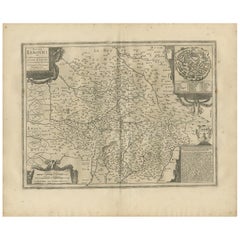
1594 Maurice Bouguereau Map of the Region Limoges, France, Ric0015
About the Item
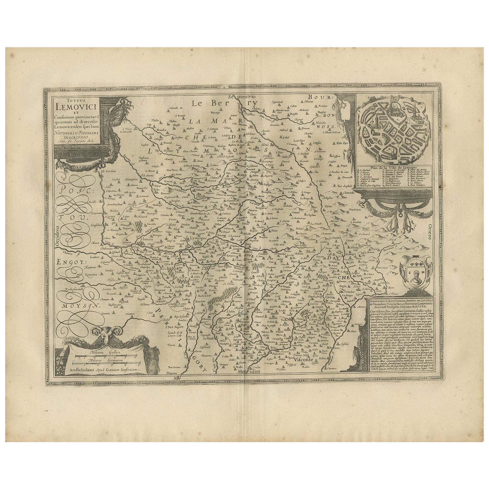
1594 Maurice Bouguereau map of the region Limoges, France, entitled
"Totivs Lemovici et Confinium Pro Uinciarum Quantum ad Dioecefin Lemo Uicenfen Fpectant,"
Hand Colored
Ric0015
Jean IV Le Clerc was an engraver, bookseller and publisher in Paris and Tours.
Son of the parisian printer and print publisher Jean III Le Clerc, brother of the librarian and print publisher David Le Clerc. Baptized on August 16, 1560, he belongs to the family of the Parisian engraver François Desprez and the painter Jérôme Bollery.
Between 1590 and 1594, he worked for the printer-librarian Maurice Bouguereau for the production of "Le Théatre François". He got in 1619 the privilege of six years to "engrave the maps of the provinces of France and the portraits of the patriarchs and princes of the Hebrew people with chronological history."
He published, engravings of Jacques Granthomme, Pierre I Firens, Leonard Gaultier and Thomas de Leu.
He died in Paris in 1621 or 1622. His son Jean V Le Clerc, also an engraver and publisher of prints, was a bookseller in 1618.
Dimension: Paper: 54 cm W x 39 cm H ; Sight: 48 cm W x 35 cm H
Condition: Good Condition with aged toning, please see photos.
- Dimensions:Height: 15.36 in (39 cm)Width: 21.26 in (54 cm)Depth: 0.4 in (1 cm)
- Materials and Techniques:
- Place of Origin:
- Period:
- Date of Manufacture:1594
- Condition:
- Seller Location:Norton, MA
- Reference Number:1stDibs: LU5848230174112
About the Seller
5.0
Platinum Seller
These expertly vetted sellers are 1stDibs' most experienced sellers and are rated highest by our customers.
Established in 2000
1stDibs seller since 2021
83 sales on 1stDibs
Typical response time: <1 hour
- ShippingRetrieving quote...Ships From: Norton, MA
- Return PolicyA return for this item may be initiated within 3 days of delivery.
More From This SellerView All
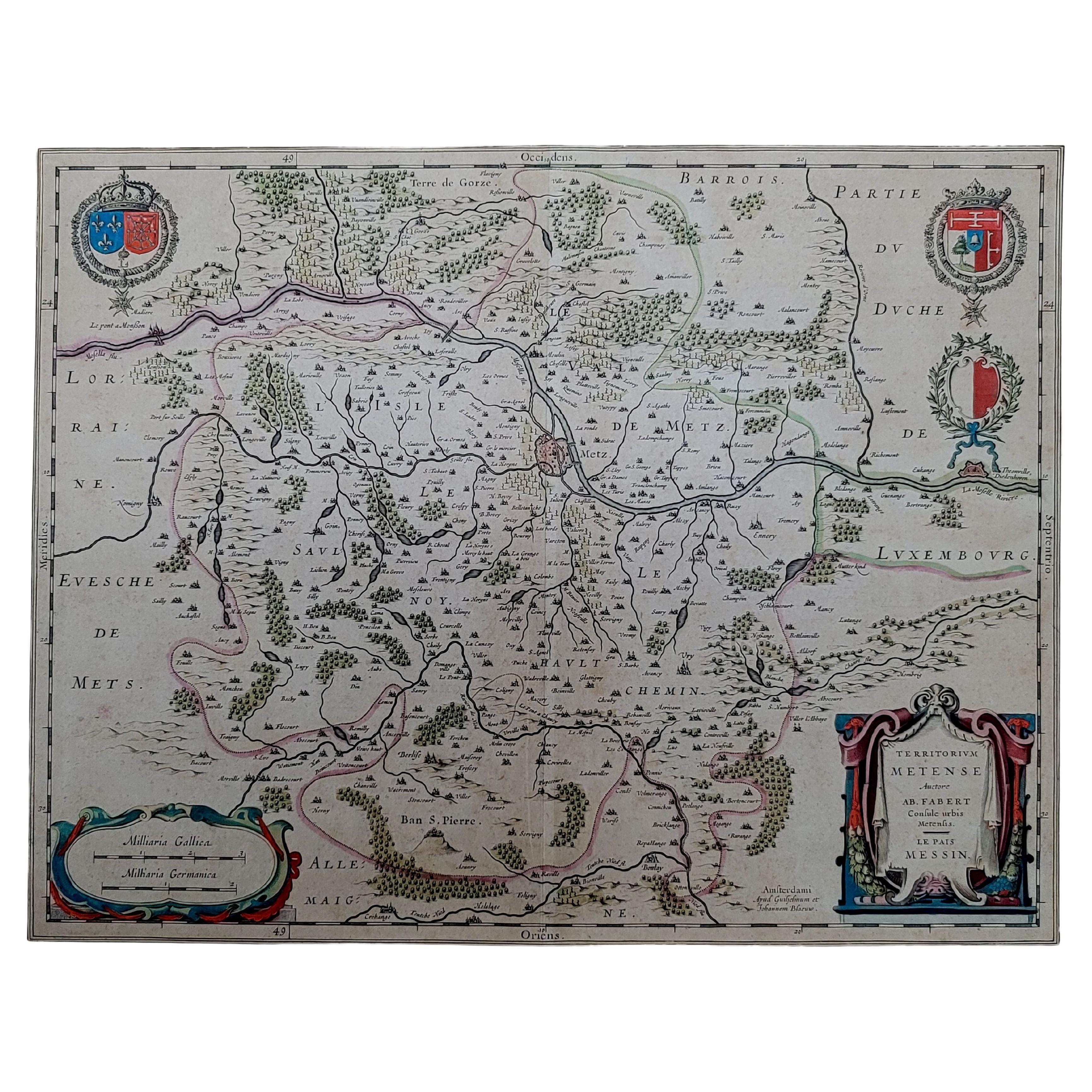
- 1656 Jansson Map Metz Region of France Entitled "Territorium Metense" Ric0014Located in Norton, MA1656 Jansson map Metz Region of France entitled "Territorium Metense." Ric0014 " Authentic" - Map of the historical region surrounding Metz, in Lorraine, France. Oriented with ...Category
Antique 17th Century Dutch Maps
MaterialsPaper
- 1752 Vaugoundy Map of Flanders : Belgium, France, and the Netherlands, Ric.a002Located in Norton, MALarge Vaugoundy Map of Flanders: Belgium, France, and the Netherlands Colored -1752 Ric.a002 Description: This is a 1752 Didier Robert de Vaugondy map of Flanders. The map de...Category
Antique 17th Century Unknown Maps
MaterialsPaper
- 1814 Map of "Russian Empire" Ric.r032Located in Norton, MA1814 Map of "Russian Empire" Ric.r032 Russian Empire. Description: This is an 1814 John Thomson map of the Russian Empire. The map depicts the region from the Baltic Sea, Prussia, and Sweden to the Aleutian Islands and from the Arctic Ocean to the Yellow River. Highly detailed, myriad cities, towns, and villages are labeled throughout, including St. Petersburg, Moscow, Minsk, Kiev, and Kharkov. Rivers and mountain ranges are also identified, as are islands and numerous locations along the coastlines. It is important to note that the long-disputed sea between Korea and Japan is identified as the 'Sea of Japan. Historical Context: In 1815, Tsarist Russia emerged from the Napoleonic Wars economically insolvent and politically fearful of the Revolutionary fervor that had just swept through Europe. In order to shore up Russia's economic position, the Tsars began an aggressive series of expansions into the Caucuses and Central Asia that would vastly increase the landmass of the Russian Empire. Publication History Thomson maps are known for their stunning color, awe inspiring size, and magnificent detail. Thomson's work, including this map, represents some of the finest cartographic art...Category
Antique 19th Century Unknown Maps
MaterialsPaper
- 1864 Johnson's Map of the World on Mercator's Projection, Ric.B009Located in Norton, MAAn 1864 Johnson's map of the World on Mercator's Projection Ric.b009 About this Item "This antique map came from Johnson's New Illustrated (Steel Plate) Family Atlas, publ...Category
Antique 19th Century Dutch Maps
MaterialsPaper
- 1625 Mercator Map of the Provenience of Quercy, "Quercy Cadvrcivm Ric.0013Located in Norton, MA1625 Mercator map of the provenience of Quercy, entitled "Quercy Cadvrcivm," Ric.0013 " Authentic" - Map of the provenience of Quercy Cadvrcivm D...Category
Antique 17th Century French Maps
MaterialsPaper
- 1858 Colton's Map of New York, Ric.B011Located in Norton, MAAn 1858 Colton's map of New York Ric.b011 Colton’s New York, 1858 - A large original color engraved and very detailed map of the state of New York,...Category
Antique 19th Century Unknown Maps
MaterialsPaper


You May Also Like
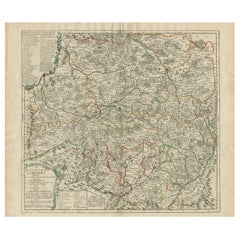
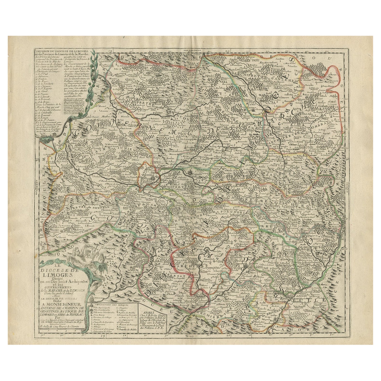
- Antique Map of the Limoges Region in France, c.1690Located in Langweer, NLAntique map titled 'Le Diocèse de Limoges'. Large map of the Limoges region, France. The map is dedicated to the bishop of Limoges, Antoine de Charpin. Artists and Engravers:...Category
Antique 17th Century Maps
MaterialsPaper
- Antique Map of the Region of Limoge by Janssonius, '1657'By Johannes JanssoniusLocated in Langweer, NLAntique map 'Totius Lemovici et consinium provinciaru quantum ad dioecesin Lemovicensen spectant'. Decorative map of the province of Limoge based on the important map of Antoin-Jean ...Category
Antique Mid-17th Century Maps
MaterialsPaper
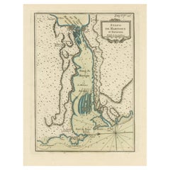
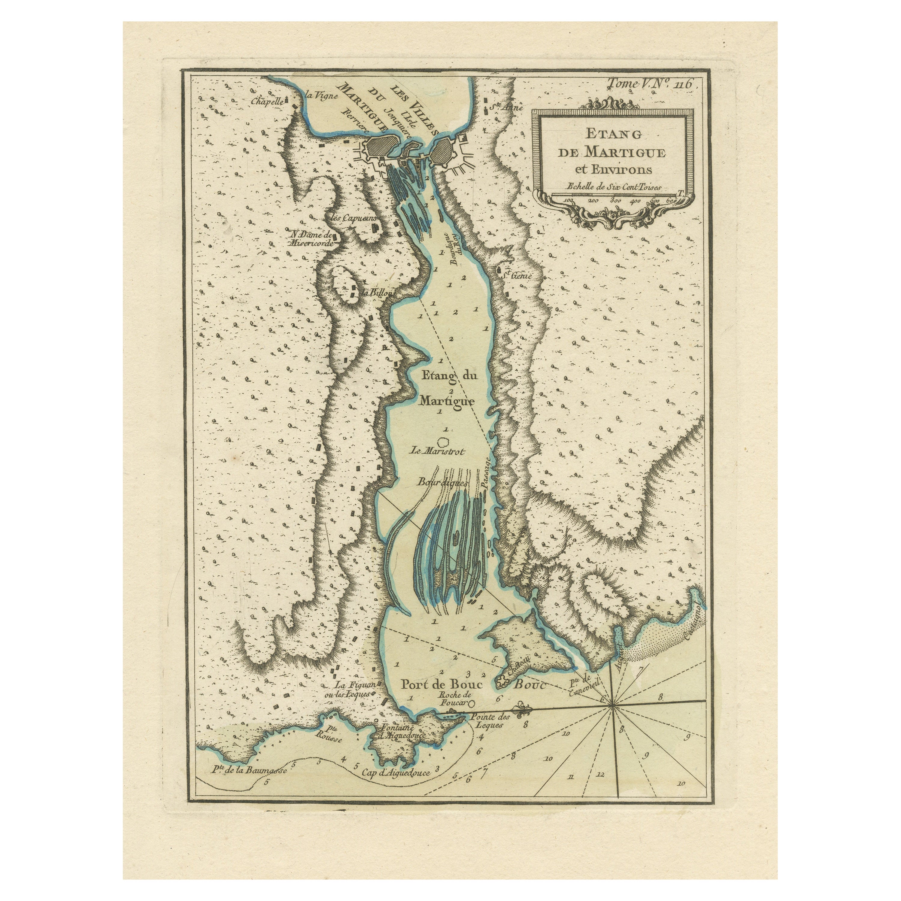
- Antique Map of the Region of Martigues, FranceLocated in Langweer, NLTitle: "Etang de Martigues et Environs: Antique Map of the Martigues Region, France" Description: This antique map, titled "Etang de Martigue et Environs," offers a detailed view of...Category
Antique Mid-18th Century Maps
MaterialsPaper
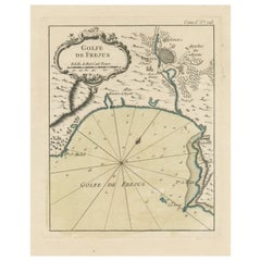
- Antique Map of the Region of Fréjus, FranceLocated in Langweer, NLTitle: "Golf de Fréjus" Description: This antique map, titled "Golf de Fréjus," is an original depiction of the region of Fréjus, France. It is part of the work "Le Petit Atlas Mari...Category
Antique Mid-18th Century Maps
MaterialsPaper
- Antique Map of the Lorraine Region 'France' (c.1735)Located in Langweer, NLAntique map titled 'Carte du Duche de Lorraine - Kaart van Lotharingen'. A detailed map of the Duchy of Lorraine. The map is surrounded by thirteen vignette bird-eye view of fortifie...Category
Antique Mid-18th Century Maps
MaterialsPaper
- Old Map Focusing on the Wine Region of Metz, the Moselle Region of France, 1657Located in Langweer, NLAntique map of France titled 'Territorium Metense'. Old map focusing on the wine region surrounding Metz, in the Moselle region of France. This map originates from 'Atlas Novus, ...Category
Antique 1650s Maps
MaterialsPaper