Items Similar to Antique Map of the Region of Fréjus, France


Want more images or videos?
Request additional images or videos from the seller
1 of 6
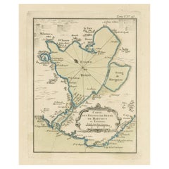
Antique Map of the Region of Fréjus, France
About the Item
Title: "Golf de Fréjus"
Description: This antique map, titled "Golf de Fréjus," is an original depiction of the region of Fréjus, France. It is part of the work "Le Petit Atlas Maritime," authored by J.N. Bellin and published in 1764. The map provides a detailed representation of the Gulf of Fréjus, offering valuable geographical information about the coastal area and its surrounding features. It serves as a historical reference to the geography of the region during the 18th century.
Bellin was an important maker of charts for the French Depot de la Marine. He was born in Paris in 1703 and educated as an engineer. He produced many important charts and published them individually and in compilations. The Neptune Francais was published in 1753 and the Hydrographie Francaise in 1756. His largest and most comprehensive work is the Petit Atlas Maritime.
- Dimensions:Height: 12.49 in (31.7 cm)Width: 8.98 in (22.8 cm)Depth: 0.02 in (0.5 mm)
- Materials and Techniques:
- Period:
- Date of Manufacture:1764
- Condition:General age-related toning. Light creasing. Minor wear and soiling, blank verso. Please study image carefully.
- Seller Location:Langweer, NL
- Reference Number:
About the Seller
5.0
Platinum Seller
These expertly vetted sellers are 1stDibs' most experienced sellers and are rated highest by our customers.
Established in 2009
1stDibs seller since 2017
1,919 sales on 1stDibs
Typical response time: <1 hour
- ShippingRetrieving quote...Ships From: Langweer, Netherlands
- Return PolicyA return for this item may be initiated within 14 days of delivery.
More From This SellerView All
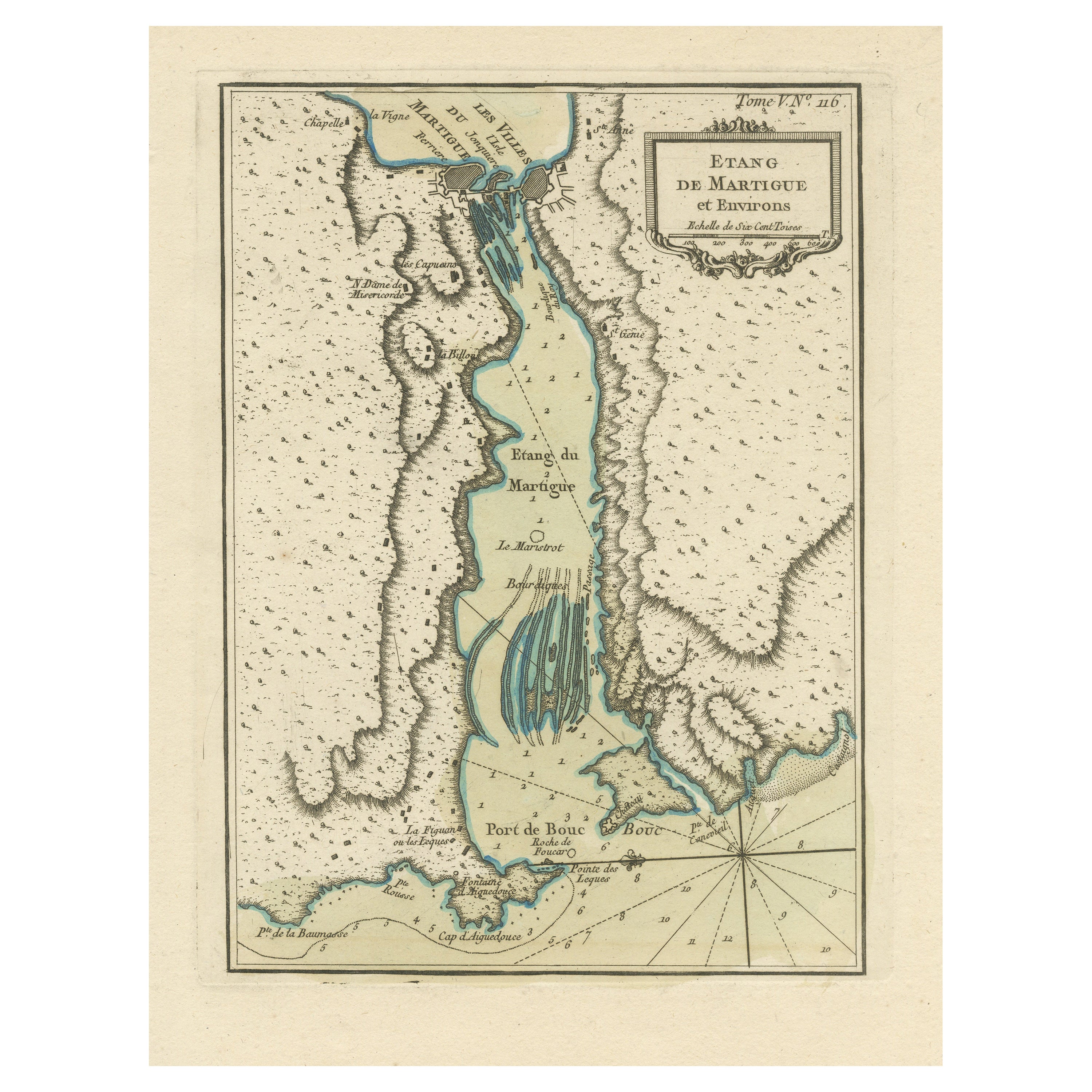
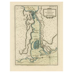
- Antique Map of the Region of Martigues, FranceLocated in Langweer, NLTitle: "Etang de Martigues et Environs: Antique Map of the Martigues Region, France" Description: This antique map, titled "Etang de Martigue et Environs," offers a detailed view of...Category
Antique Mid-18th Century Maps
MaterialsPaper
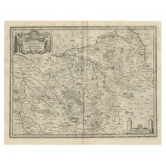
- Antique Map of the Lorraine Region 'France' (c.1735)Located in Langweer, NLAntique map titled 'Carte du Duche de Lorraine - Kaart van Lotharingen'. A detailed map of the Duchy of Lorraine. The map is surrounded by thirteen vignette bird-eye view of fortifie...Category
Antique Mid-18th Century Maps
MaterialsPaper
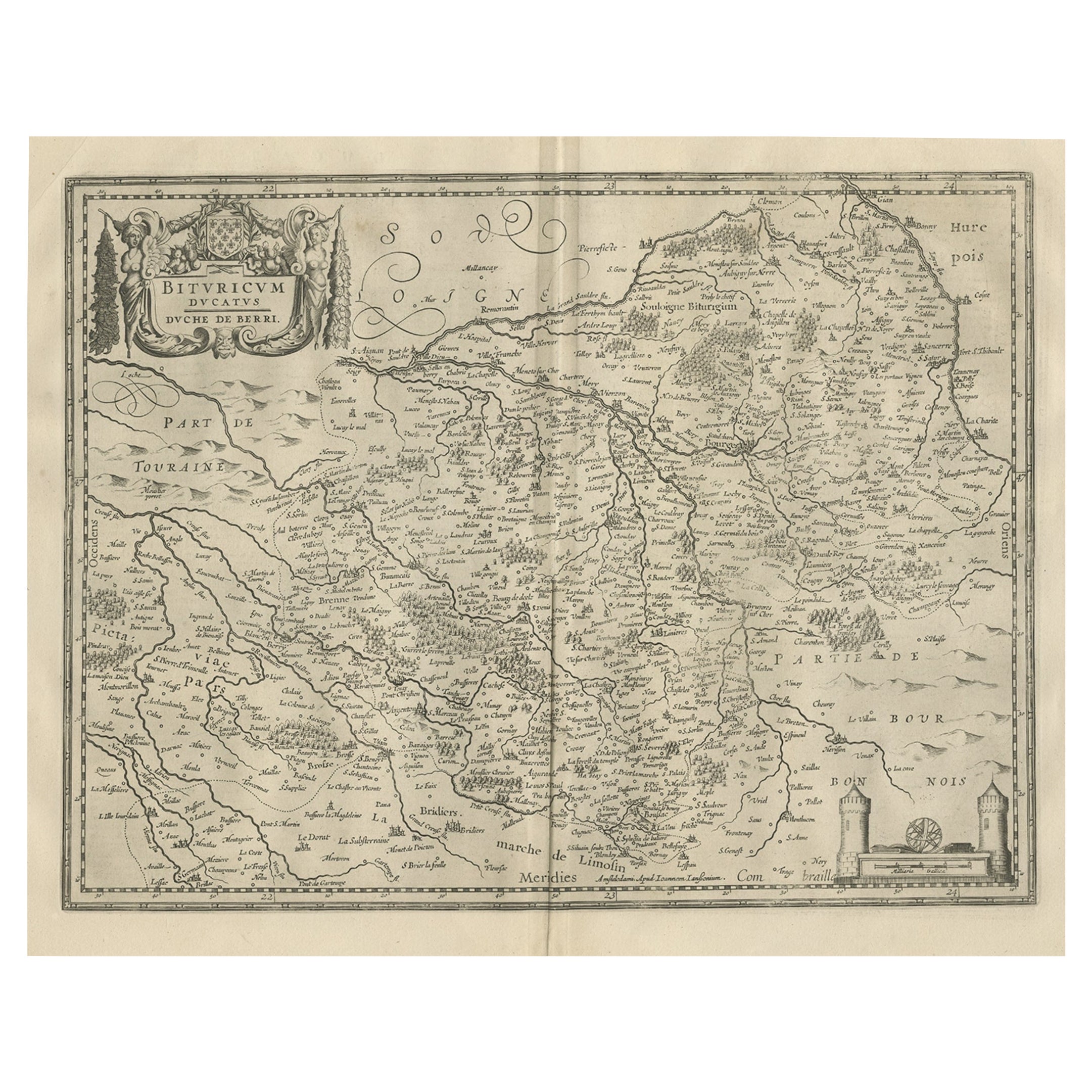
- Decorative Antique Map of the Berry Region, France, 1657Located in Langweer, NLAntique map of France titled 'Bituricum Ducatus - Duche de Berri'. Decorative map of the Berry region, France. Berry is a region located in the center of France. It was a provinc...Category
Antique 1650s Maps
MaterialsPaper
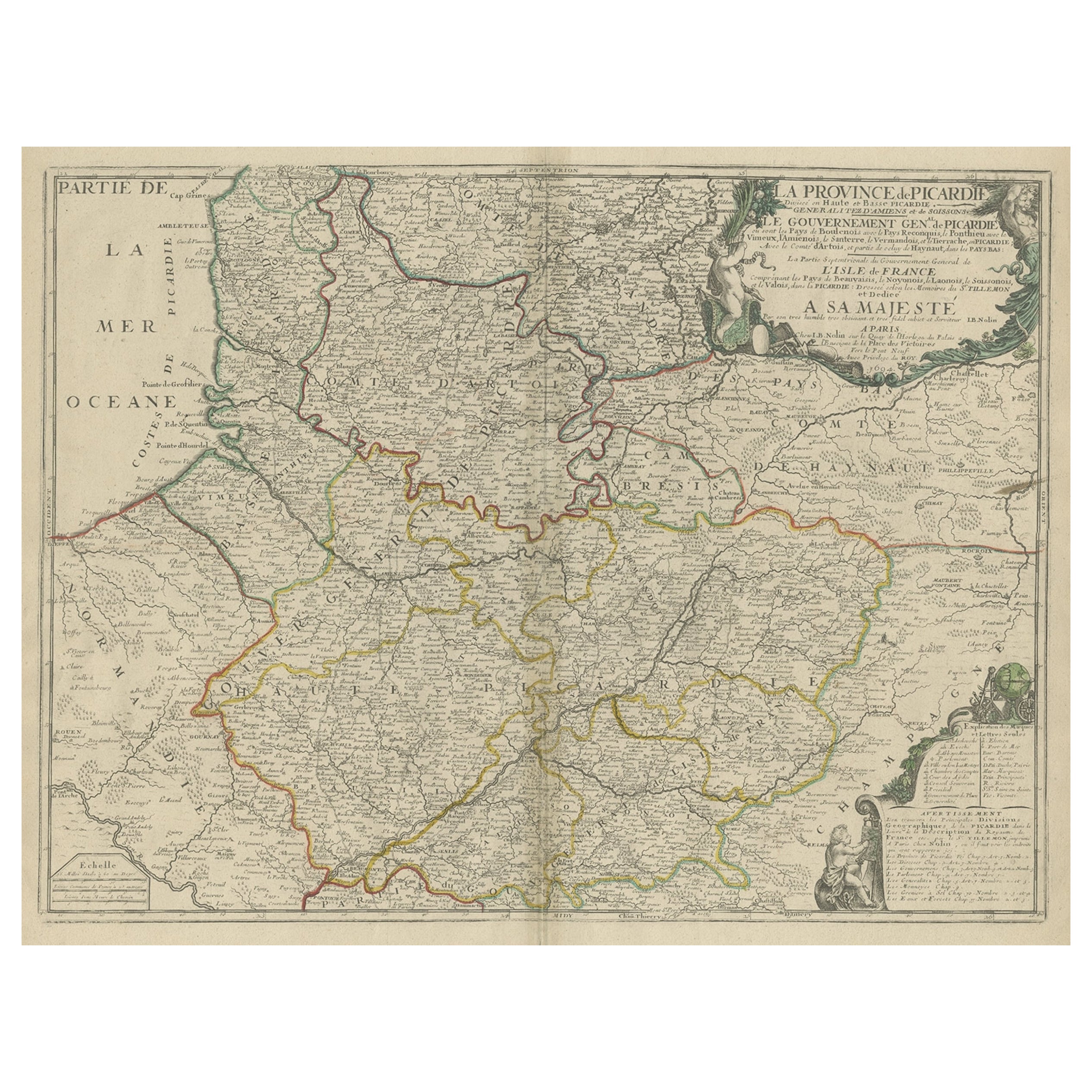
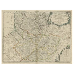
- Large Antique Map of the Picardy Region of France, 1694Located in Langweer, NLAntique map titled 'La Province de Picardie (..)'. Large map of the Picardy region of France. Shows the cities of Beaumont, Mondidier, Lille and others. Artists and Engravers...Category
Antique 1690s Maps
MaterialsPaper
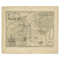
- Antique Map of the Region of Cambrai in France, c.1630Located in Langweer, NLAntique map titled 'l'Archevesche de Cambray'. Decorative map of the region of Cambrai, France. Includes the cities of Cambrai, Valencienes, Douai, and Bouchain. Artists and Engrav...Category
Antique 17th Century Maps
MaterialsPaper
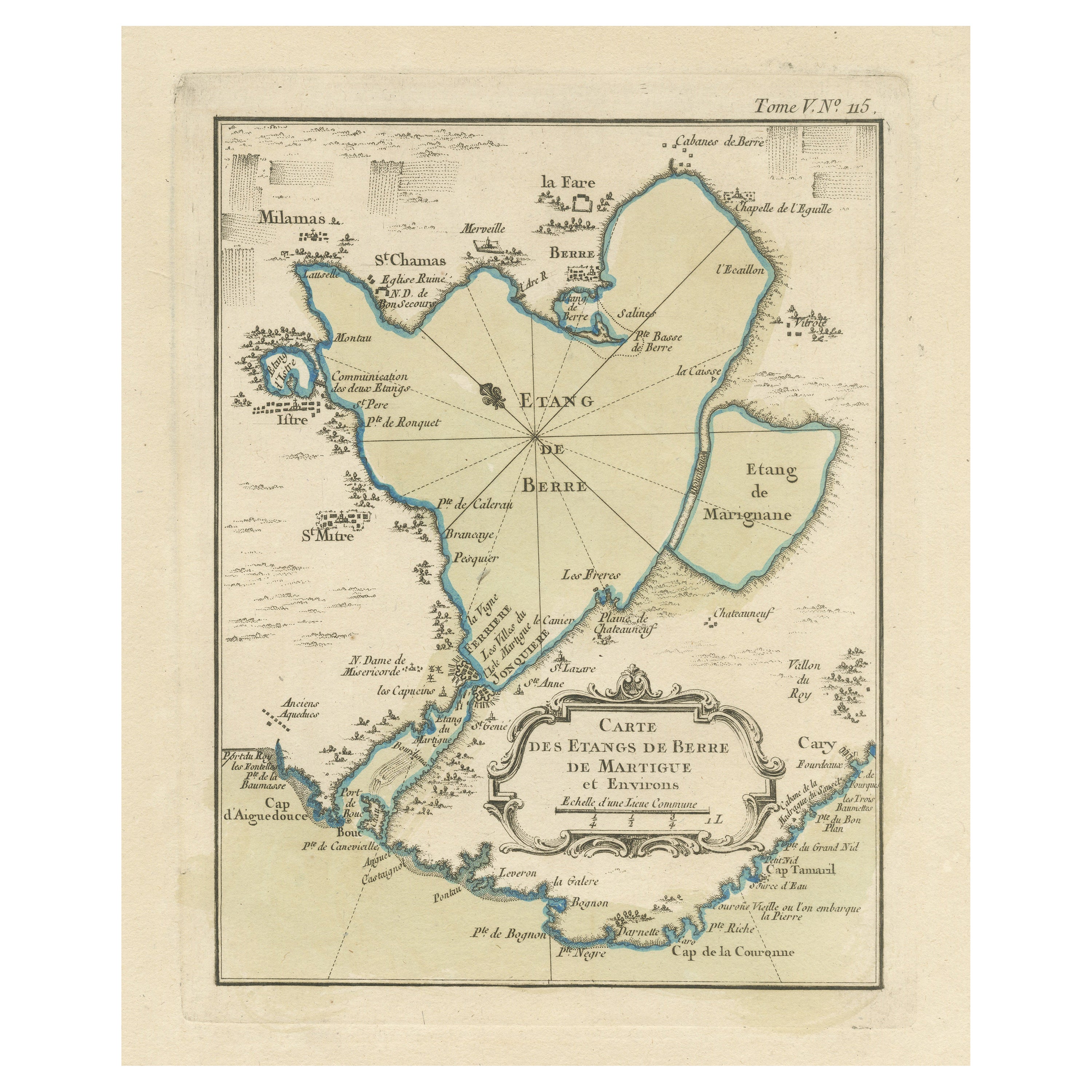
- Antique Map of the Region of Berre-l'Étang, FranceLocated in Langweer, NLAntique map titled 'Carte des etangs de Berre de Martigue et environs'. Original map of the region of Berre-l'Étang, France. This map originates from 'Le Petit Atlas Maritime (..)' b...Category
Antique Mid-18th Century Maps
MaterialsPaper

You May Also Like
- The Normandy Region of France: A 17th C. Hand-colored Map by Sanson and JaillotBy Nicolas SansonLocated in Alamo, CAThis large hand-colored map entitled "Le Duché et Gouvernement de Normandie divisée en Haute et Basse Normandie en divers Pays; et par evêchez, avec le Gouvernement General du Havre ...Category
Antique 1690s French Maps
MaterialsPaper
- 17th Century Topographical Map of Cote D'azur, Avignon, Frejus by Iohan PeetersLocated in New York, NYFine topographical 17th century map by Iohan Peeters of the towns of Avignon and Frejus in the Cote d'Azur-Provence-Alpes Region of Southeastern France. Beautifully suited decorativ...Category
Antique 17th Century Dutch Maps
MaterialsPaper
- Original Antique Map of France, Arrowsmith, 1820Located in St Annes, LancashireGreat map of France Drawn under the direction of Arrowsmith. Copper-plate engraving. Published by Longman, Hurst, Rees, Orme and Brown, 1820 Unframed.Category
Antique 1820s English Maps
MaterialsPaper
- 17th Century Hand Colored Map of the Liege Region in Belgium by VisscherBy Nicolaes Visscher IILocated in Alamo, CAAn original 17th century map entitled "Leodiensis Episcopatus in omnes Subjacentes Provincias distincté divisusVisscher, Leodiensis Episcopatus" by Nicolaes Visscher II, published in Amsterdam in 1688. The map is centered on Liege, Belgium, includes the area between Antwerp, Turnhout, Roermond, Cologne, Trier and Dinant. This attractive map is presented in a cream-colored mat measuring 30" wide x 27.5" high. There is a central fold, as issued. There is minimal spotting in the upper margin and a tiny spot in the right lower margin, which are under the mat. The map is otherwise in excellent condition. The Visscher family were one of the great cartographic families of the 17th century. Begun by Claes Jansz Visscher...Category
Antique Late 17th Century Dutch Maps
MaterialsPaper
- 17th Century Topographical Map, French Champagne Region, Epernay, Iohan PeetersLocated in New York, NYFine topographical 17th century map by Iohan Peeters of the towns of Epernay and Lametz in the Champagne Region of North Eastern France. Fabulous period engraving for a Wine Cellar,...Category
Antique 17th Century Dutch Maps
MaterialsPaper
- Map of the Republic of GenoaLocated in New York, NYFramed antique hand-coloured map of the Republic of Genoa including the duchies of Mantua, Modena, and Parma. Europe, late 18th century. Dimension: 25...Category
Antique Late 18th Century European Maps


Recently Viewed
View AllMore Ways To Browse
1681 Moses Pitt
Antique Cabbage Cutter
Antique Chesapeake Bay Map
Antique Handcrafted Model Sailboat
Antique Map Of Chesapeake Bay
Cartier 1730
Devonia Antique
Eso Antique Map
Eso Antique Maps
Formosa Vintage Map
M S Merian
Union Pacific Map
Ian Maguire
Map Scandinavia
Pakistan Antique Map
Antique Map Iceland
Antique Map Of Iceland
Antique Map Scandinavia