Antique World Globe Map
2
to
21
146
44
125
75
51
48
24
21
16
16
14
13
12
12
9
9
8
6
5
5
4
4
3
3
3
3
3
3
2
2
2
2
1
1
1
1
1
1
1
1
1
1
28
5
4
2
1
Sort By
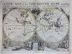
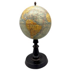
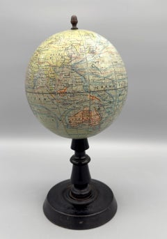
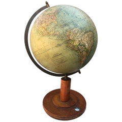
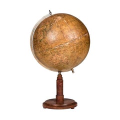
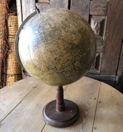
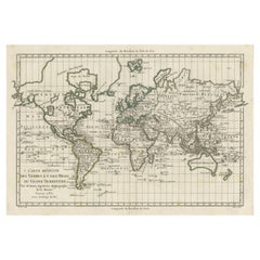
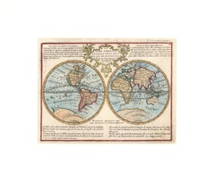
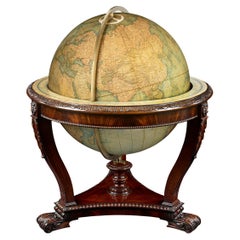
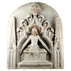
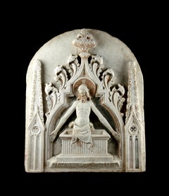
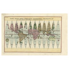
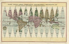
Antique Map of the World in 12 Globe Gores by Scherer, 'circa 1702'
Located in Langweer, NL
Superinducendus'. Beautiful example of Scherer's map of the World, configured in 12 globe gores. California is
Category
Early 18th Century Antique World Globe Map
Materials
Paper
19th CENTURY PAIR OF SMALL WORLD GLOBES
Located in Firenze, FI
, equipped with three legs and a pedestal, making them stable. The first world map represents the terrestrial
Category
19th Century Italian Antique World Globe Map
Materials
Brass
Colored wall map of the WORLD
By Chambon
Located in ZWIJNDRECHT, NL
huge wall map of the world in two hemispheres printed on two sheets, depicting the Eastern and Western
Category
Mid-18th Century French French Provincial Antique World Globe Map
Materials
Wood, Paper
Antique Geological Map of the World by Johnston '1850'
Located in Langweer, NL
Antique map titled 'The Geological Structure of the Globe'. Original antique geological map of the
Category
Mid-19th Century Antique World Globe Map
Materials
Paper
Antique Map of the World Showing the Distribution of Plants and Minerals, 1872
Located in Langweer, NL
(..)'. Original world map showing the distribution of plants and minerals over the globe. This map originates from
Category
Late 19th Century Antique World Globe Map
Materials
Paper
H 13.39 in W 16.93 in D 0.02 in
Antique Kittinger 8-inch Terrestrial World Globe on a Mahogany Wooden Stand
By Kittinger Furniture Company
Located in Philadelphia, PA
A fine, antique 8 inch terrestrial globe.
Manufactured by Kittinger Company, Inc. (in
Category
Early 20th Century Antique World Globe Map
Materials
Mahogany, Gesso, Wood, Paper
H 18 in W 11.5 in D 11.5 in
Terrestrial Globe by W. & A.K. Johnston
By W. & A.K. Johnston
Located in New Orleans, LA
incredibly expensive to create. At a time when the world’s map was constantly changing, it proved to be much
Category
19th Century English Victorian Antique World Globe Map
Materials
Brass
Pocket Globe by Nathaniel Hill, London 1754
Located in Milano, IT
., Globes from the Western World, London 1993, p. 115.)
Nathaniel Hill (London, news from 1746 to 1768) had
Category
1750s English George II Antique World Globe Map
Materials
Shagreen, Paper
English Pocket Globe, London, Circa 1775-1798
By Herman Moll
Located in Milano, IT
Netherlands, Utrecht 1984, p. 146 and Van der Krogt, P. - Dekker, E., Globes from the Western World, London
Category
Late 18th Century English George III Antique World Globe Map
Materials
Shagreen, Paper
A truly delightful miniature terrestrial pocket globe
By Nathaniel Mills
Located in ZWIJNDRECHT, NL
astronomers, and later by the Islamic world, where the earliest known globes date from the eleventh century
Category
Mid-18th Century British Dutch Colonial Antique World Globe Map
Materials
Other
An exceptional pair of BLAEU table globes
By Willem Blaeu
Located in ZWIJNDRECHT, NL
maps, atlases and instruments. Blaeu’s globes were luxury items for wealthy and intellectual merchants
Category
17th Century European Dutch Colonial Antique World Globe Map
Materials
Other
A huge pair of 21 inches Cruchley Library Globes
By G.F. Cruchley
Located in ZWIJNDRECHT, NL
, published by G.F. Cruchley, map-seller & globe maker, 81 Fleet street.
Signed: CRUCHLEY in London England
Category
1850s British Victorian Antique World Globe Map
Materials
Other
A beautiful Celestial Table Globe produced by Gerard & Leonard Valk
By Gerard and Leonard Valk
Located in ZWIJNDRECHT, NL
unique opportunity to acquire an exceptional celestial globe from one of the major world globe publishers
Category
Early 18th Century Dutch Dutch Colonial Antique World Globe Map
Materials
Other
Antique Map of Asia by Delamarche, 1826
Located in Langweer, NL
publish maps and globes until the middle part of the 19th century.
Condition: Very good. General age
Category
19th Century Antique World Globe Map
Materials
Paper
Antique Map of Africa by Delamarche, 1806
Located in Langweer, NL
firm continued to publish maps and globes until the middle part of the 19th century.
Condition: Good
Category
19th Century Antique World Globe Map
Materials
Paper
Antique Map of Friesland by Guicciardini, 1613
Located in Langweer, NL
over the world. Our collection includes a wide range of authentic antique maps from the 16th to the
Category
17th Century Antique World Globe Map
Materials
Paper
Antique Map of Northwestern India by Weller, 1857
Located in Langweer, NL
years 1856 and 1862 included in each edition a map of a part of the world. During this period a total of
Category
19th Century Antique World Globe Map
Materials
Paper
Antique Map of Herefordshire by Morden, c.1700
Located in Langweer, NL
. Robert Morden (c. 1650 ? 1703) was an English bookseller, publisher, and maker of maps and globes. He was
Category
18th Century Antique World Globe Map
Materials
Paper
Antique Map of Asia by Malte-Brun, 1880
Located in Langweer, NL
Map Pl. 63 - 64: 'Carte de l'Asie.' This map shows Asia. This original antique map originates from
Category
19th Century Antique World Globe Map
Materials
Paper
Antique Map of the Coast of Guinea, Africa, 1820
Located in Langweer, NL
Equatorial Guinea. This map originates from a reissue of Raynal's 'Atlas de toutes les parties du Globe
Category
19th Century Antique World Globe Map
Materials
Paper
Antique Map of the Eastern Hemisphere by Wyld, 1842
Located in Langweer, NL
original antique maps to collectors, historians, educators and interior decorators all over the world. Our
Category
19th Century Antique World Globe Map
Materials
Paper
Antique Map of South America Depicting Guayana, c.1780
Located in Langweer, NL
Antique map titled 'La Guyane Francopise avec partie de la Guyane Hollandoise: suivant les
Category
18th Century Antique World Globe Map
Materials
Paper
1633 Map Entitled "Beauvaisis Comitatus Belova Cium, Ric.0002
Located in Norton, MA
Flanders, he grew up in Ghent, apprenticed as an instrument and globe maker and map engraver. In 1584, to
Category
17th Century Dutch Antique World Globe Map
Materials
Paper
Antique Map of the Holy Land by Delamarche, 1806
By Charles Francois Delamarche
Located in Langweer, NL
firm continued to publish maps and globes until the middle part of the 19th century.
Condition: Good
Category
19th Century Antique World Globe Map
Materials
Paper
Antique Map of the Pacific Ocean by Renneville, 1702
Located in Langweer, NL
several Delamarche publications in the mid-19th century. The firm continued to publish maps and globes
Category
18th Century Antique World Globe Map
Materials
Paper
Antique Map of Gelderland and Overijssel by Guicciardini, 1613
Located in Langweer, NL
Antique map titled 'Geldria et Transisulania.' (Map of the provinces of Gelderland and Overijssel
Category
17th Century Antique World Globe Map
Materials
Paper
End XIX century Small Terrestrial Globe Signed C.M.C Paris Papier Maché Sphere
Located in Milan, IT
Small terrestrial globe signed C.M.C. Paris, end of XIX century. Papier maché sphere and turned and
Category
1890s French Antique World Globe Map
Materials
Paper
Pair of George III 3 inch pocket globes by J & W Cary, one dated 1791
Located in Lymington, Hampshire
engraved map of the ‘world as known in CÆSAR’s Time agreeable to D’Anville’ and ‘A Table of Latitudes
Category
1790s English Antique World Globe Map
Materials
Shagreen
Rare Antique Map of Germany with English Text, c.1690
Located in Langweer, NL
, publisher, and maker of maps and globes.
Artist: Robert Morden (c. 1650 ? 1703) was an English bookseller
Category
17th Century Antique World Globe Map
Materials
Paper
Antique Map of the Coast of Guinea, Africa, c.1780
Located in Langweer, NL
Antique map Africa titled 'Carte de la Haute et de la Basse Guinée'. Map of the Coast of Guinea
Category
18th Century Antique World Globe Map
Materials
Paper
Antique Map of Coiba Island, Panama, South America, C.1740
Located in Langweer, NL
original antique maps to collectors, historians, educators and interior decorators all over the world. Our
Category
18th Century Antique World Globe Map
Materials
Paper
Antique Map of the Maluku Islands by Blaeu, c.1640
Located in Langweer, NL
skills. Blaeu set up shop in Amsterdam, where he sold instruments and globes, published maps, and edited
Category
17th Century Antique World Globe Map
Materials
Paper
Antique Map of the French Province of Quercy, ca.1625
Located in Langweer, NL
first map in 1537 and became a cartographer and globe maker. In 1552 he moved to Duisburg, Germany where
Category
17th Century Antique World Globe Map
Materials
Paper
Antique Map of Harvey Island and Surroundings by Cook, 1803
Located in Langweer, NL
largely uncharted areas of the globe. He mapped lands from New Zealand to Hawaii in the Pacific Ocean in
Category
19th Century Antique World Globe Map
Materials
Paper
Free Shipping
H 13.19 in W 16.34 in D 0 in
Antique Map of Central America Showing the Communication Lines, 1850
Located in Langweer, NL
map-seller, best known for Wyld's Great Globe. He was successor to William Faden, one of the
Category
19th Century Antique World Globe Map
Materials
Paper
Old Map of the Bourbonnais Region of France, ca.1630
Located in Langweer, NL
famous 18-sheet world map in 1569 with his own new projection, today called Mercator projection. Later he
Category
1630s Antique World Globe Map
Materials
Paper
Antique Map of Guinea in West Africa by Blaeu, c.1638
Located in Langweer, NL
founded a business as globe maker. Later he started producing map and sea charts, including his first
Category
17th Century Antique World Globe Map
Materials
Paper
Antique Map of the Coast of Northwest Africa by Dien, 1820
Located in Langweer, NL
map originates from a reissue of Raynal's 'Atlas de toutes les parties du Globe Terrestre
Category
19th Century Antique World Globe Map
Materials
Paper
Antique Map of the Coast of Acapulco by Anson, c.1740
Located in Langweer, NL
interior decorators all over the world. Our collection includes a wide range of authentic antique maps from
Category
18th Century Antique World Globe Map
Materials
Paper
Antique Map of the Northern Part of Brazil by Raynal, 1784
Located in Langweer, NL
the world. Our collection includes a wide range of authentic antique maps from the 16th to the 20th
Category
18th Century Antique World Globe Map
Materials
Paper
Attractive Antique Map of Asia with Borders Hand-Coloured, c.1780
Located in Langweer, NL
antique maps to collectors, historians, educators and interior decorators all over the world. Our
Category
18th Century Antique World Globe Map
Materials
Paper
Antique Map of The Dutch Provinces of Gelderland and Overijssel, 1623
Located in Langweer, NL
world map in 1569 with his own new projection, today called Mercator projection. Later he decided to
Category
17th Century Antique World Globe Map
Materials
Paper
Antique Map of Macedonia by the Famous Mapmaker Blaeu, c.1650
Located in Langweer, NL
started producing map and sea charts, including his first world map in 1605. His most famous work was the
Category
17th Century Antique World Globe Map
Materials
Paper
Antique Map of the Southern Lorraine Region by Mercator, c.1625
By Gerard Mercator
Located in Langweer, NL
drawn his first map in 1537 and became a cartographer and globe maker. In 1552 he moved to Duisburg
Category
17th Century Antique World Globe Map
Materials
Paper
1643 Willem&Joan Blaeu Map NW Flanders "Flandriae Teutonicae Pars Prientalior
Located in Norton, MA
. Later he started producing maps and sea charts, including his first world map in 1605. In 1633 he was
Category
17th Century Dutch Antique World Globe Map
Materials
Paper
H 19.3 in W 22.45 in D 0.4 in
Original Antique Map the Imperial States of the Habsburg Netherlands, 1609
Located in Langweer, NL
famous 18-sheet world map in 1569 with his own new projection, today called Mercator projection. Later he
Category
Early 1600s Antique World Globe Map
Materials
Paper
H 20.08 in W 25.2 in D 0 in
Mid-19th Century Decorative Map of India with Cultural and Natural Vignettes
Located in Langweer, NL
The Tallis maps, including the one of India, are known for their detailed and ornamental style
Category
1850s Antique World Globe Map
Materials
Paper
H 14.26 in W 10.71 in D 0 in
Antique Map of Northern Ireland by Mercator/Hondius, Early 1600's
Located in Langweer, NL
Antique map titled 'Ultoniae Orientalis Pars'. Original antique map of Northern Ireland. Published
Category
16th Century Antique World Globe Map
Materials
Paper
Miniature Terrestrial Globe Newton & Son London, Post 1833, Ante 1858
By Newton and Son
Located in Milano, IT
. Van der Krogt, E. Dekker, Globes from the Western World, London 1993, pp. 115-118;
E. Dekker, Globes
Category
1840s English Early Victorian Antique World Globe Map
Materials
Bronze
Scarce Antique Map of the Middle East, Surrounded by Latin Text, 1624
Located in Langweer, NL
, surrounded by Latin text. The two insets show Israel and an oval world map. This map (from the last edition
Category
1620s Antique World Globe Map
Materials
Paper
Original Antique Map of Utrecht in the Netherlands by Blaeu, C.1645
Located in Langweer, NL
Brahe. 1599 he went to Amsterdam and founded a business as globe maker. Later he started producing map
Category
17th Century Antique World Globe Map
Materials
Paper
Interesting Antique Engraving of the World in Hemispheres with 6 Diagrams, 1788
Located in Langweer, NL
Antique map titled 'De Nieuwe en Ouden oppervlakke en doorzigtkundige Aardrykes Bollen (..)'. Twin
Category
Late 18th Century Antique World Globe Map
Materials
Paper
H 8.08 in W 11.03 in D 0.02 in
Old Map of Part of France: Poitou, Berry, Bourbonnais, and Nivernais in 1768
Located in Langweer, NL
maps of France and other parts of the world.
The area that the map is about includes central French
Category
1760s Antique World Globe Map
Materials
Paper
H 13.19 in W 20.28 in D 0 in
Antique Map of the Banda Islands or Spice Islands, Moluccas, Indonesia, 1697
Located in Langweer, NL
mathematician, cartographer and globe maker. He was very infuential, compiled and engraved over 500 maps
Category
17th Century Antique World Globe Map
Materials
Paper
H 18.9 in W 13 in D 0 in
Antique Map of the Province of Groningen in the Netherlands, c.1700
Located in Langweer, NL
interests as print sellers, publishers of books, maps, topographical and architectural drawings and globes
Category
18th Century Antique World Globe Map
Materials
Paper
Early Antique Map of Gelderland and Overijssel in the Netherlands, c.1625
Located in Langweer, NL
world map in 1569 with his own new projection, today called Mercator projection. Later he decided to
Category
17th Century Antique World Globe Map
Materials
Paper
H 15.75 in W 21.46 in D 0 in
Map of the Duchy Clivia & Ravestein, Brabant in The Netherlands & Germany, 1635
Located in Langweer, NL
founded a business as globe maker. Later he started producing map and sea charts, including his first
Category
1630s Antique World Globe Map
Materials
Paper
H 16.86 in W 22.05 in D 0 in
Antique Map of the Northern Part of South America by Delamarche, 1806
Located in Langweer, NL
firm continued to publish maps and globes until the middle part of the 19th century.
Condition: Good
Category
19th Century Antique World Globe Map
Materials
Paper
Old Engraved Map of Hungary, European Balkan Countries, Greece and Crete, 1806
Located in Langweer, NL
publications in the mid-19th century. The firm continued to publish maps and globes until the middle part of
Category
19th Century Antique World Globe Map
Materials
Paper
H 15.08 in W 11.34 in D 0 in
Map of East Friesland, The Netherlands & the Area Emden & Norden, Germany, 1635
Located in Langweer, NL
globe maker. Later he started producing map and sea charts, including his first world map in 1605. In
Category
1630s Antique World Globe Map
Materials
Paper
H 20.48 in W 24.34 in D 0 in
- 1
Get Updated with New Arrivals
Save "Antique World Globe Map", and we’ll notify you when there are new listings in this category.
Antique World Globe Map For Sale on 1stDibs
At 1stDibs, there are many versions of the ideal antique world globe map for your home. Each antique world globe map for sale was constructed with extraordinary care, often using paper, metal and wood. Your living room may not be complete without an antique world globe map — find older editions for sale from the 18th Century and newer versions made as recently as the 20th Century. An antique world globe map is a generally popular piece of furniture, but those created in Georgian, Louis XVI and neoclassical styles are sought with frequency. You’ll likely find more than one antique world globe map that is appealing in its simplicity, but Gerard Mercator, Cary’s and Charles Francois Delamarche produced versions that are worth a look.
How Much is a Antique World Globe Map?
Prices for an antique world globe map start at $49 and top out at $240,832 with the average selling for $870.
More Ways To Browse
Antique Map Israel
Regency Portrait Pastel
Alessandro Men
Map Antarctica
Antique Navigation Charts
Hessen Antique
Japanese Screen Geisha
Antique Pocket Calendar
John Mont
Speed Antique Map
Colombia Map
Antique Maps Of North Carolina
Bodega Bay
Spice Fish
Celeste Dresses
Antique Astronomy Books
Antique Map Chile
Map Panama