Items Similar to Rare Antique Map of Germany with English Text, c.1690


Want more images or videos?
Request additional images or videos from the seller
1 of 5
Rare Antique Map of Germany with English Text, c.1690
About the Item
Antique map Germany titled 'Germani by Robt. Morden'. Rare antique map of Germany. Originates from 'Atlas Terestris'. Artists and Engravers: Robert Morden (c. 1650 ? 1703) was an English bookseller, publisher, and maker of maps and globes.
Artist: Robert Morden (c. 1650 ? 1703) was an English bookseller, publisher, and maker of maps and globes.
Condition: Good, some spots (also near Elbe river). English text on verso, please study image carefully.
Date: c.1690
Overall size: 15.5 x 20 cm.
Image size: 12 x 10 cm.
We sell original antique maps to collectors, historians, educators and interior decorators all over the world. Our collection includes a wide range of authentic antique maps from the 16th to the 20th centuries. Buying and collecting antique maps is a tradition that goes back hundreds of years. Antique maps have proved a richly rewarding investment over the past decade, thanks to a growing appreciation of their unique historical appeal. Today the decorative qualities of antique maps are widely recognized by interior designers who appreciate their beauty and design flexibility. Depending on the individual map, presentation, and context, a rare or antique map can be modern, traditional, abstract, figurative, serious or whimsical. We offer a wide range of authentic antique maps for any budget.
- Dimensions:Height: 7.88 in (20 cm)Width: 6.11 in (15.5 cm)Depth: 0 in (0.01 mm)
- Materials and Techniques:
- Period:
- Date of Manufacture:circa 1690
- Condition:
- Seller Location:Langweer, NL
- Reference Number:
About the Seller
5.0
Platinum Seller
These expertly vetted sellers are 1stDibs' most experienced sellers and are rated highest by our customers.
Established in 2009
1stDibs seller since 2017
1,932 sales on 1stDibs
Typical response time: <1 hour
- ShippingRetrieving quote...Ships From: Langweer, Netherlands
- Return PolicyA return for this item may be initiated within 14 days of delivery.
More From This SellerView All
- Rare Antique Map of the Middle East, ca.1690Located in Langweer, NLDescription: Antique print, untitled. Two decorative maps on one sheet of the middle east in biblical times. Source unknown, to be determined. Artists and Engravers: Anonymous...Category
Antique 1690s Prints
MaterialsPaper
- Antique Map of Denmark by Valk 'circa 1690'Located in Langweer, NLThe map titled "Regnum Daniae, divisum in Dioeceses Arhusiam, Albergum, Viborgum, et Ripam (..)" is a meticulously detailed representation of the Kingdom of Denmark during a historic...Category
Antique Late 17th Century Maps
MaterialsPaper
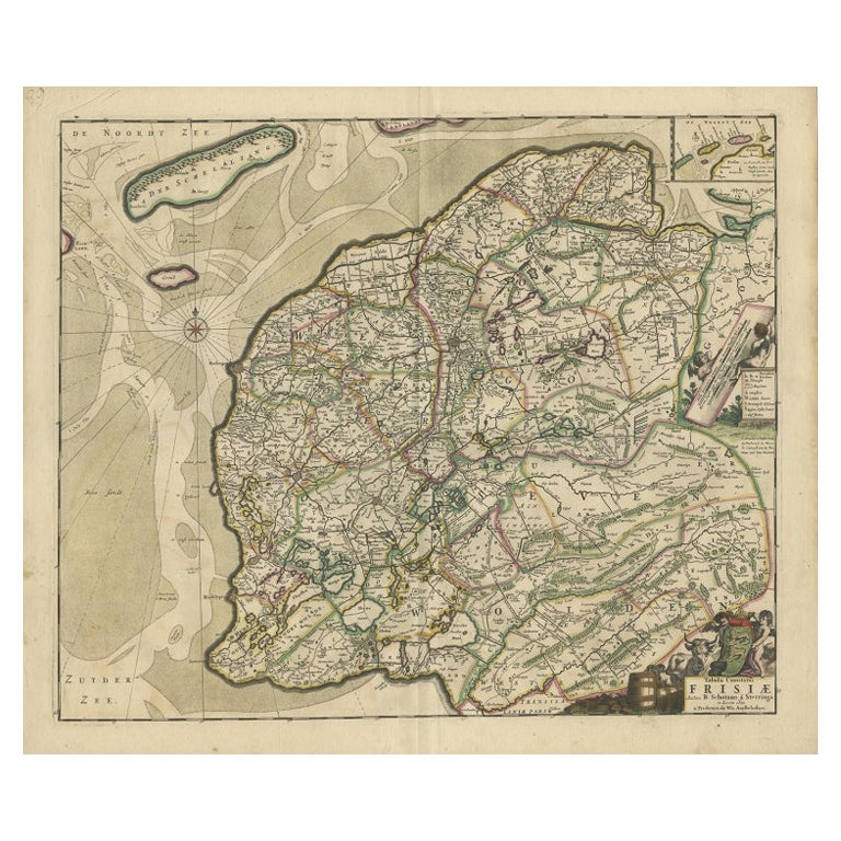
- Antique Map of Friesland by De Wit, c.1690Located in Langweer, NLAntique map titled 'Tabula Comitatus Frisiae'. Old map of the province of Friesland, the Netherlands. With a small inset map of the Wadden area. Third state of the map by Schotan...Category
Antique 17th Century Maps
MaterialsPaper
- Antique Map of Austria by N. Visscher, circa 1690Located in Langweer, NLAntique map titled 'Austriae Archiducatus pars superior in omnes ejusdem'. Spectacular large map of Upper and Lower Austria between Passau and Wien with figurative cartouche and armo...Category
Antique Late 17th Century Maps
MaterialsPaper
- Antique Map of Switzerland by N. Visscher, circa 1690Located in Langweer, NLBeautifully detailed map of Switzerland and surrounding regions in present-day France, Germany, and Italy. This map features two decorative cartouches: the larger is flanked by two p...Category
Antique Late 17th Century Maps
MaterialsPaper
- Antique Map of Austria by F. de Wit, 1690Located in Langweer, NLAntique map titled 'Circuli Austriaci pars Septentrionalis in qua Archiducatus'. Decorative and detailed map of Austria by F. de Wit.Category
Antique Late 17th Century Maps
MaterialsPaper


You May Also Like
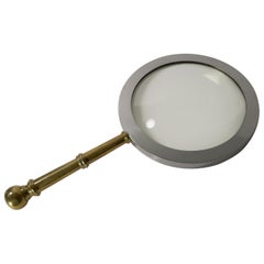
- Rare Antique English Mammoth Map or Library Magnifying Glass, circa 1930Located in Bath, GBWow, you need to hands to lift this mammoth magnifying glass, a great look for the library and a real talking point. The handle is made from cast brass and the frame for the glass...Category
Vintage 1930s English Art Deco Scientific Instruments
MaterialsMetal
- East German MapBy VEB Hermann HaackLocated in Baltimore, MDA brilliantly colourful map of the Leipzig, Karl Marx Stadt and Dresden area in the former German Democratic Republic by VEB Hermann Haack of Gotha.Category
Vintage 1970s German Maps
- Set of 4 Antique Geographical Maps French-German War 1870-71Located in Casale Monferrato, ITElegant late 19th century set of four antique geographical maps relating to the positioning of the armies in the Franco-German War 1870-71. A...Category
Antique 1890s Italian Maps
MaterialsPaper
- William & Mary Rare Pewter Trefid Spoon with Portraits, Circa 1690Located in Bishop's Stortford, HertfordshireVery rare William and Mary pewter trefid spoon the handle molded in relief with portraits and dating from around 1690. The spoon has an elongated rounded ...Category
Antique 17th Century English William and Mary Political and Patriotic Me...
MaterialsPewter
- Antique Lithography Map, Isle of Wight, English, Framed, Engraving, CartographyLocated in Hele, Devon, GBThis is an antique lithography map of the Isle of Wight. An English, framed atlas engraving of cartographic interest, dating to the early 19th century and later. Superb lithography ...Category
Antique Early 19th Century British Regency Maps
MaterialsWood
- Antique Lithography Map, Isle of Thanet, Kent, English, Cartography, VictorianLocated in Hele, Devon, GBThis is an antique lithography map of The Isle of Thanet in Kent. An English, framed atlas engraving of cartographic interest, dating to the mid 19th century and later. Superb litho...Category
Antique Mid-19th Century British Victorian Maps
MaterialsWood


Recently Viewed
View AllMore Ways To Browse
Antique English Collectibles
Antique Globes Of The World
20 C Design
16th Century English
World Globe Rare
English 16th Century Furniture
Antique English 17th Century
16th Century English Antique
Antique English Maps
17th Century World Map
17th C English
Used Booksellers
Used Bookseller
Antique 17th Century World Map
Antique Maps And Globes
Antique Globes And Maps
Antique Paper Globe
World Map Globe