Items Similar to Old Map of Part of France: Poitou, Berry, Bourbonnais, and Nivernais in 1768
Want more images or videos?
Request additional images or videos from the seller
1 of 6
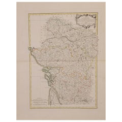
Old Map of Part of France: Poitou, Berry, Bourbonnais, and Nivernais in 1768
About the Item
The map with text neatly mounted on both sides of the map on the plate, is a section of an old map with accompanying French text. The map mentions several historical French provinces such as Poitou, Berry, Bourbonnais, and Nivernais, which are all regions in France. The text also refers to Moulins, which is a city in the Allier department in the center of France.
The text included on the map gives a hint about its creation, as it states "Chez Desnos Ingenieur Geographe Rue St.Jacques au Globe", which indicates that the map was made by an engineer or geographer named Desnos, located on Rue St. Jacques, possibly in Paris. The mention of "au Globe" could suggest that this was the name of his studio or shop. The date provided on the map is 1768.
More research is needed as we have been unable to provide more specific details about the map or its creator and we cannot find a similar one online. However, the name Desnos is associated with Louis Charles Desnos (1725–1805), who was an important French cartographer and geographical engineer of the 18th century. He was known for his work in globe making as well as his detailed maps of France and other parts of the world.
The area that the map is about includes central French regions, with a focus on administrative divisions and possibly routes or distances, as indicated by the legend referring to "lieues", a French unit of distance used at the time.
- Dimensions:Height: 13.19 in (33.5 cm)Width: 20.28 in (51.5 cm)Depth: 0 in (0.02 mm)
- Materials and Techniques:Paper,Engraved
- Period:1760-1769
- Date of Manufacture:1768
- Condition:Good. Folding line as issued. Aged paper with typically warm, yellowish-brown hue. One fold in corner, not affecting the image. Study the images carefully.
- Seller Location:Langweer, NL
- Reference Number:
About the Seller
5.0
Platinum Seller
These expertly vetted sellers are 1stDibs' most experienced sellers and are rated highest by our customers.
Established in 2009
1stDibs seller since 2017
1,919 sales on 1stDibs
Typical response time: <1 hour
- ShippingRetrieving quote...Ships From: Langweer, Netherlands
- Return PolicyA return for this item may be initiated within 14 days of delivery.
More From This SellerView All
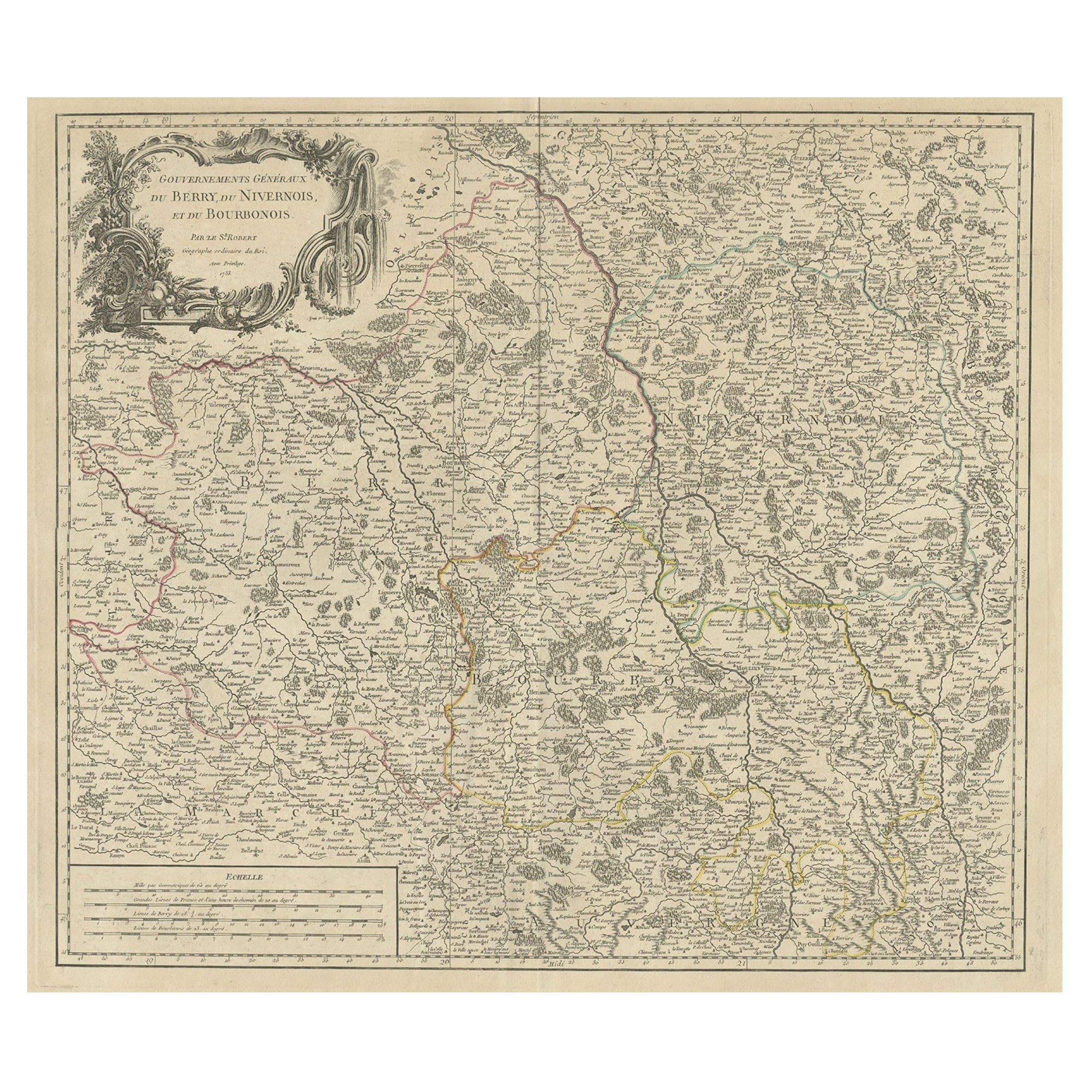
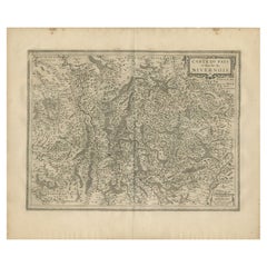
- Large Antique Map of the Region of Berry, Nivernois & Bourbonnais, France, 1753Located in Langweer, NLAntique map titled 'Gouvernements généraux du Berry, du Nivernois et du Bourbonois'. Large, original antique map of the region of Berry, Nivernois and Bourbonnais, France. Featur...Category
Antique 1750s Maps
MaterialsPaper
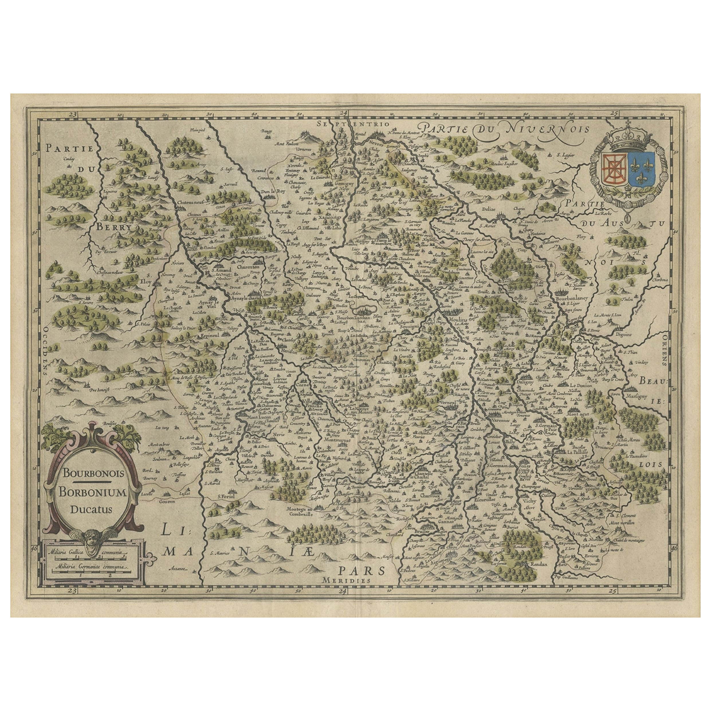
- Old Map of the Bourbonnais Region of France, ca.1630Located in Langweer, NLAntique map titled 'Bourbonois - Borbonium Ducatus'. Old map of the Bourbonnais region of France. Bourbonnais was a historic province in the centre of France that corresponds to ...Category
Antique 1630s Maps
MaterialsPaper
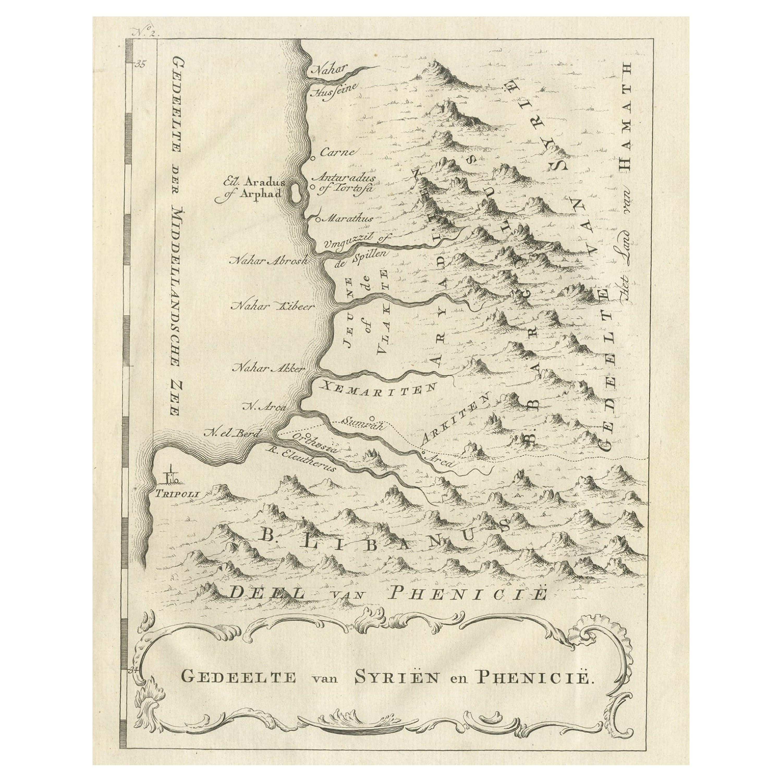
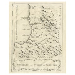
- Old Dutch Map of Part of Syria and Phoenicia, 1773Located in Langweer, NLAntique print titled 'Gedeelte van Syriën en Phenicië'. Old map of part of Syria and Phoenicia. Originates from the first Dutch editon of an interesting travel account of Norther...Category
Antique 1770s Maps
MaterialsPaper
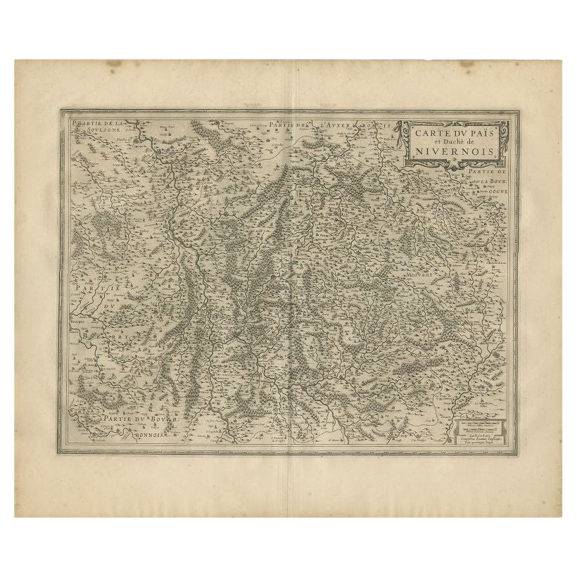
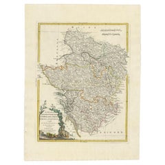
- Antique Map of the Region of Nivernais by Janssonius, 1657By Johannes JanssoniusLocated in Langweer, NLAntique map of France titled 'Carte du Païs et Duché de Nivernois'. Decorative map of the Nivernais region, part of Burgundy, France. This map originates from 'Atlas Novus, Sive Thea...Category
Antique 17th Century Maps
MaterialsPaper
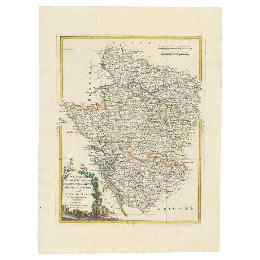
- Antique Map of the Region of Poitou and Saintonge by Zatta (1779)Located in Langweer, NLAntique map titled 'Li Governi d'Angio del Saumurois, della Touraine et Poitou d'Aunis et Saintonge'. Old map of France showing the provinces of Poitou and Saintonge with their adjac...Category
Antique 18th Century Maps
MaterialsPaper
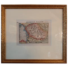
- Antique Miniature Map of the region of Poitou 'France' by Bertius, circa 1600Located in Langweer, NLAntique map titled 'Poictou'. Miniature map of the region of Poitou, France. Published by Pieter Bertius, circa 1600. Frame included. We carefully pack our framed items to ensure...Category
Antique Early 17th Century Maps
MaterialsPaper
You May Also Like
- 1771 Bonne Map of Poitou, Touraine and Anjou, France, Ric.a015Located in Norton, MA1771 Bonne Map of Poitou, Touraine and Anjou, France Ric.a015 1771 Bonne map of Potiou, Touraine and Anjou entitled "Carte des Gouvernements D'Anjou et du Saumurois, de la Touraine, du Poitou,du Pays d'aunis, Saintonge?Angoumois," Carte des gouvernements d'Anjou et du Saumurois, de la Touraine, du Poitou, du Pays d'Aunis, Saintonge-Angoumois. Projettee et assujettie au ciel par M. Bonne, Hyd. du Roi. A Paris, Chez Lattre, rue St. Jacques a la Ville de Bord(ea)ux. Avec priv. du Roi. 1771. Arrivet inv. & sculp., Atlas moderne ou collection de cartes sur toutes...Category
Antique 17th Century Unknown Maps
MaterialsPaper
- 1844 Map "Russia in Eurpoe, Part II to Part VIII", 7 Maps Ric.r023Located in Norton, MA1844 Map "Russia in Eurpoe, Part II to Part VIII" 7 Maps Ric.r023 Fine, original, steel-engraved Map of Russia in Europe Part II t oPart VIII, by the Society for the Diffusion of Useful Knowledge. Detailed map of the regions to the northeast of Moscow. Including Arkhangel, Vologda, Viatka, Perm, Olonetz, Iaroslavl. The SDUK began its map publishing project under the leadership of Captain Francis Beaufort R.N. in 1829, and published the maps in parts, haltingly, over the next 15 years, completing the series in 1844, finally permitting the publication of a whole atlas. Many of the maps were actually drawn by Beaufort, who at the time was the Hydrographer to the Royal Navy, and all were closely supervised by him. J. & C. Walker worked closely with Beaufort in engraving the maps. Finely engraved, carefully researched, the maps set...Category
Antique 19th Century Unknown Maps
MaterialsPaper
- Old Nautical Map of CorsicaLocated in Alessandria, PiemonteST/556/1 - Old map of Corsica isle, surveyed by Captain Hell, of the French Royal Navy in 1824, engraved and published on 1874, with additions and corre...Category
Antique Early 19th Century English Other Prints
MaterialsPaper
- Old Horizontal Map of EnglandBy TassoLocated in Alessandria, PiemonteST/520 - Old rare Italian map of England, dated 1826-1827 - by Girolamo Tasso, editor in Venise, for the atlas of M.r Le-Sage.Category
Antique Early 19th Century Italian Other Prints
MaterialsPaper
- Map of the Kingdom of Sardinia and Part of the Kingdom of Genoa, RomeBy Giovanni Maria CassiniLocated in Hamilton, Ontario18th century map by Italian engraver Giovanni Maria Cassini (Italy 1745-1824). Map of Part of the Kingdom of Sardinia and Part of the Kingdom of Genoa: Rome. This is a hand colored a...Category
Antique 18th Century Italian Maps
MaterialsPaper
- 1633 Map, Entitled "La Douche De Berry, " Ric.0005Located in Norton, MA1633 map, entitled "La douche de Berry," Hand Colored Ric.0005 Description: 1633 map, entitled "La douche de Berry," Dimension: Paper: 23.3" W x 20.3" H (59 cm W x 51.7 c...Category
Antique 17th Century Unknown Maps
MaterialsPaper


Recently Viewed
View AllMore Ways To Browse
De Nile Antiques
Serbia Map
1859 Asia Map
Levasseur A
Antique Map Copenhagen
Antique Map Of Finland
Antique Map Singapore
Antique Maps Singapore
Map Prussia Germany
Frontier Map
Antique Detroit Map
Antique Map Of Detroit
Shetland Map
Victor Levasseur On Sale
Antique Life Buoy
Antique Map Of South Korea
Rail Road Collectables
Wyld Globes