Items Similar to Antique Map of Asia by Malte-Brun, 1880


Want more images or videos?
Request additional images or videos from the seller
1 of 6
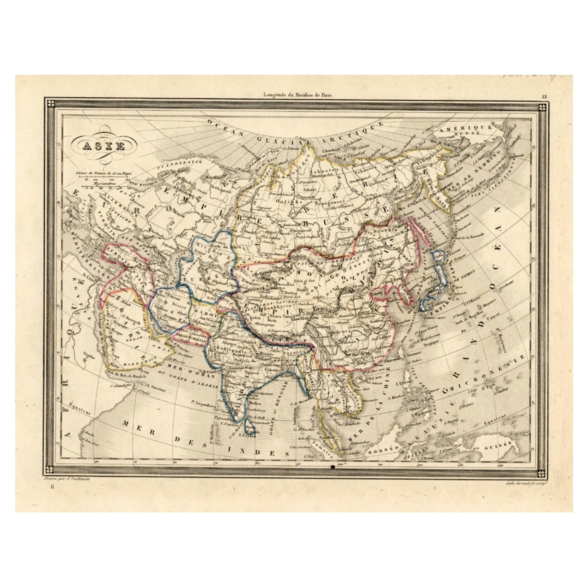
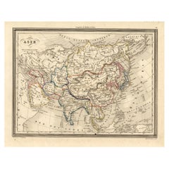
Antique Map of Asia by Malte-Brun, 1880
About the Item
Map Pl. 63 - 64: 'Carte de l'Asie.' This map shows Asia. This original antique map originates from 'Atlas de la Geographie Universelle ou Description de toutes les parties du monde sur un plan nouveau d'apres les grandes divisions naturelles du globe' by Malte-Brun and Huot. Published by P. Garnier in France, 1880. The lithographic maps are by Pierre Sarrazin.
Artists and Engravers: Conrad Malte-Brun (1755 - 1826), born Malthe Conrad Bruun, was a Danish-French geographer and journalist. His second son, Victor Adolphe Malte-Brun, was also a geographer.
Condition: Good. General age related toning and soiling. Small tear middle fold bottom margin, backed. Please study image carefully.
Date: 1880
Overall size: 55 x 39 cm.
Image size: 43 x 31 cm.
We sell original antique maps to collectors, historians, educators and interior decorators all over the world. Our collection includes a wide range of authentic antique maps from the 16th to the 20th centuries. Buying and collecting antique maps is a tradition that goes back hundreds of years. Antique maps have proved a richly rewarding investment over the past decade, thanks to a growing appreciation of their unique historical appeal. Today the decorative qualities of antique maps are widely recognized by interior designers who appreciate their beauty and design flexibility. Depending on the individual map, presentation, and context, a rare or antique map can be modern, traditional, abstract, figurative, serious or whimsical. We offer a wide range of authentic antique maps for any budget.
- Dimensions:Height: 15.36 in (39 cm)Width: 21.66 in (55 cm)Depth: 0 in (0.01 mm)
- Materials and Techniques:
- Period:
- Date of Manufacture:1880
- Condition:
- Seller Location:Langweer, NL
- Reference Number:
About the Seller
5.0
Platinum Seller
These expertly vetted sellers are 1stDibs' most experienced sellers and are rated highest by our customers.
Established in 2009
1stDibs seller since 2017
1,933 sales on 1stDibs
Typical response time: <1 hour
- ShippingRetrieving quote...Ships From: Langweer, Netherlands
- Return PolicyA return for this item may be initiated within 14 days of delivery.
More From This SellerView All
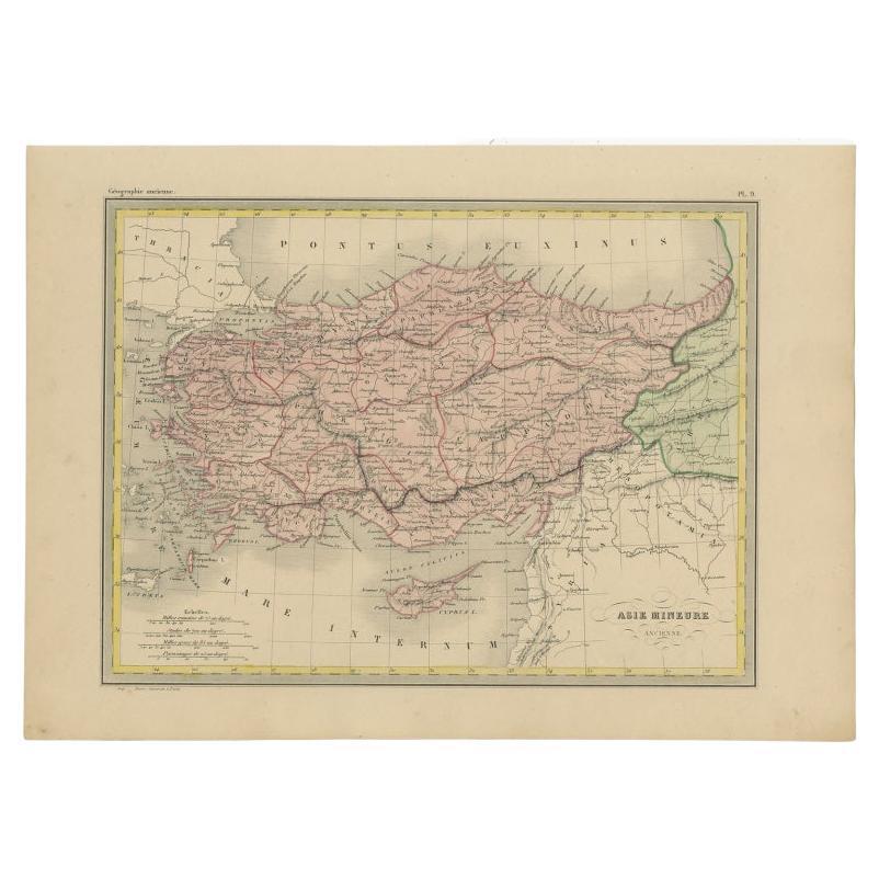
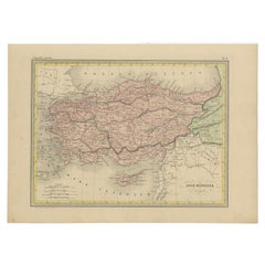
- Antique Map of Asia Minor by Malte-Brun, 1847Located in Langweer, NLAntique map titled 'Asie Mineure Ancienne'. This is an original antique map of Asia Minor from Malte Brun's "" Atlas de Géographie Universelle"", revised by...Category
Antique 19th Century Maps
MaterialsPaper
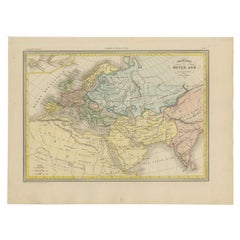
- Antique Map of Europe in the Middle Ages by Malte-Brun, 1850Located in Langweer, NLAntique map titled 'Géographie du Moyen Age principalement au IXe Siècle'. Early French map of Europe indicating the geography of Europe in the Middle Ages. This map originates from ...Category
Antique 19th Century Maps
MaterialsPaper
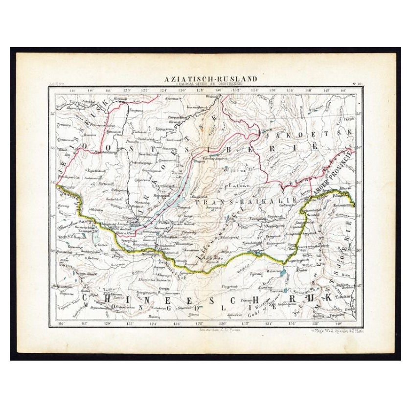
- Antique Map of Russia in Asia by Kuyper, c.1880Located in Langweer, NLAntique map plate 48 : 'Aziatisch Rusland. Balkasj Meer en omstreken.' Original antique map of Russia in Asia, showing Lake Balkhash and surroundings. This l...Category
Antique 19th Century Maps
MaterialsPaper
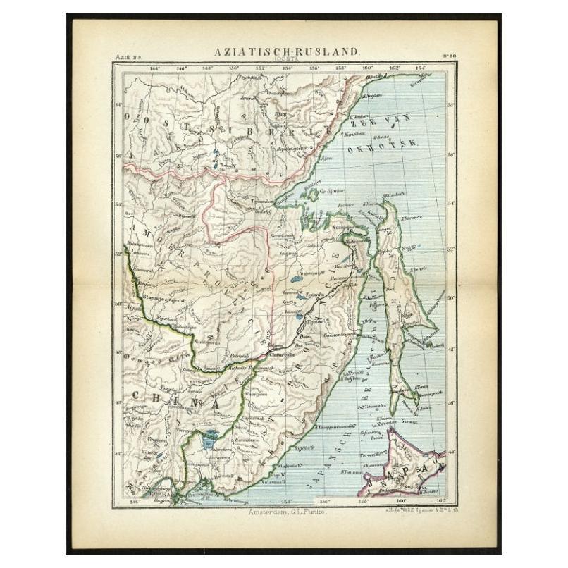
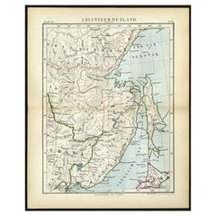
- Antique Map of Eastern Russia in Asia by Kuyper, 1880Located in Langweer, NLAntique map titled 'Aziatisch Rusland. Oost'. Original antique map of Eastern Russia in Asia. This lithographed map originates from: 'Wereld-atlas voor ...Category
Antique 19th Century Maps
MaterialsPaper
- Antique Map of Asia, 1846Located in Langweer, NLAntique map titled 'Asie'. Original antique map of Asia. Source unknown, to be determined. Artists and Engravers: Alexandre Vuillemin (1812-188...Category
Antique 19th Century Maps
MaterialsPaper
- Antique Map of Asia by Tirion 'c.1760'Located in Langweer, NLAntique map titled 'Nuova Carta dell Asia'. Decorative map of Asia. Published by I. Tirion, circa 1760.Category
Antique Mid-18th Century Maps
MaterialsPaper


You May Also Like
- Original Antique Map of Asia. C.1780Located in St Annes, LancashireGreat map of Asia Copper-plate engraving Published C.1780 Two small worm holes to right side of map Unframed.Category
Antique Early 1800s English Georgian Maps
MaterialsPaper

- Original Antique Map of Cyprus. Circa 1880Located in St Annes, LancashireGreat map of Cyprus Drawn and Engraved by R.Walker Published W.Mackenzie, London Original colour Unframed.Category
Antique 1880s English Maps
MaterialsPaper
- Large Original Antique Map of Asia by Sidney Hall, 1847Located in St Annes, LancashireGreat map of Asia Drawn and engraved by Sidney Hall Steel engraving Original colour outline Published by A & C Black. 1847 Unframed Free shippingCategory
Antique 1840s Scottish Maps
MaterialsPaper
- Original Antique Map of South East Asia by Becker, circa 1840Located in St Annes, LancashireGreat map of South East Asia Steel engraving with original color outline Engraved by Becker Published by Virtue, circa 1840. Unframed.Category
Antique 1840s English Other Maps
MaterialsPaper
- Original Antique Map of South East Asia, Arrowsmith, 1820Located in St Annes, LancashireGreat map of South East Asia Drawn under the direction of Arrowsmith Copper-plate engraving Published by Longman, Hurst, Rees, Orme and Brown, 1820 Unframed.Category
Antique 1820s English Maps
MaterialsPaper
- Antique French Map of Asia Including China Indoneseia India, 1783Located in Amsterdam, Noord HollandVery nice map of Asia. 1783 Dedie au Roy. Additional information: Country of Manufacturing: Europe Period: 18th century Qing (1661 - 1912) Condition: Overall Condition B (Good Used)...Category
Antique 18th Century European Maps
MaterialsPaper


Recently Viewed
View AllMore Ways To Browse
Antique Globes Of The World
Map Of Asia
Asian P
Map Asia
Maps Asia
Antique Map Asia
Antique Maps Asia
Asia Antique Map
Antique Maps Of Asia
Antique Map Of Asia
Antique French Globe
Antiques Du Monde
Antique Globes And Maps
Antique Maps And Globes
Antique Paper Globe
World Map Globe
Small Antique Globes
Antique Asian Maps