Items Similar to Antique Map of Russia in Asia by Kuyper, c.1880
Want more images or videos?
Request additional images or videos from the seller
1 of 5
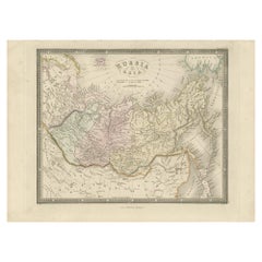
Antique Map of Russia in Asia by Kuyper, c.1880
About the Item
Antique map plate 48 : 'Aziatisch Rusland. Balkasj Meer en omstreken.' Original antique map of Russia in Asia, showing Lake Balkhash and surroundings. This lithographed map originates from: 'Wereld-atlas voor Kantoor en Huiskamer' (transl: World Atlas for the office and living room), by J. Kuyper, published in 1880 - 1882 in Amsterdam, The Netherlands by G. L. Funke. Artists and Engravers: Jacob Kuyper (1821 - 1908), Dutch cartographer.
Artist: Jacob Kuyper (1821 - 1908), Dutch cartographer.
Condition: Good, given age. Original middle fold, as issued. Minimal staining in fold. General age-related toning or occasional minor defects from handling. Please study image carefully.
Date: c.1880
Overall size: 23.7 x 18.9 cm.
Image size: 0.001 x 20.1 x 16.5 cm.
Antique prints have long been appreciated for both their aesthetic and investment value. They were the product of engraved, etched or lithographed plates. These plates were handmade out of wood or metal, which required an incredible level of skill, patience and craftsmanship. Whether you have a house with Victorian furniture or more contemporary decor an old engraving can enhance your living space. We offer a wide range of authentic antique prints for any budget.
- Dimensions:Height: 7.45 in (18.9 cm)Width: 9.34 in (23.7 cm)Depth: 0 in (0.01 mm)
- Materials and Techniques:
- Period:
- Date of Manufacture:circa 1880
- Condition:
- Seller Location:Langweer, NL
- Reference Number:
About the Seller
5.0
Platinum Seller
These expertly vetted sellers are 1stDibs' most experienced sellers and are rated highest by our customers.
Established in 2009
1stDibs seller since 2017
1,928 sales on 1stDibs
Typical response time: <1 hour
- ShippingRetrieving quote...Ships From: Langweer, Netherlands
- Return PolicyA return for this item may be initiated within 14 days of delivery.
More From This SellerView All
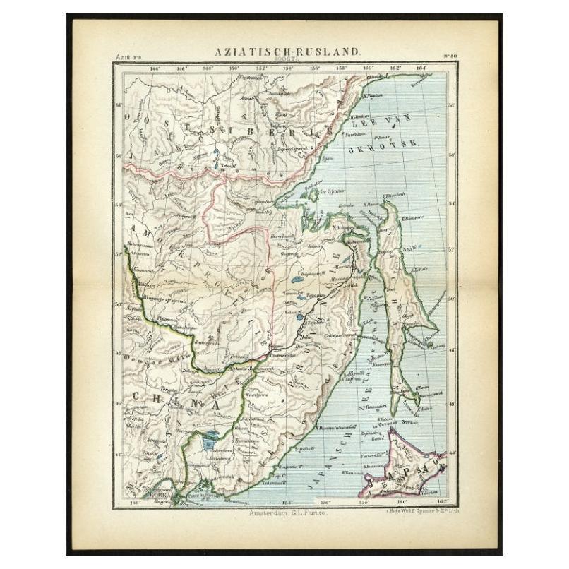
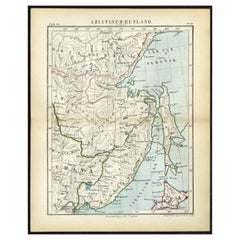
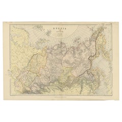
- Antique Map of Eastern Russia in Asia by Kuyper, 1880Located in Langweer, NLAntique map titled 'Aziatisch Rusland. Oost'. Original antique map of Eastern Russia in Asia. This lithographed map originates from: 'Wereld-atlas voor ...Category
Antique 19th Century Maps
MaterialsPaper
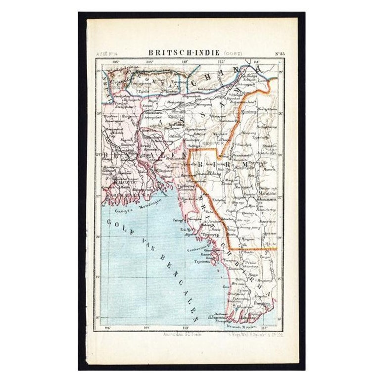
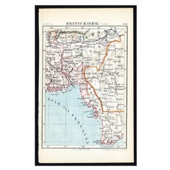
- Antique Map of Eastern India by Kuyper, C.1880Located in Langweer, NLPlate 55 : 'Britsch-Indie, Oost.' (British Indies, East). This lithographed map originates from: 'Wereld-atlas voor Kantoor en Huiskamer' (transl: World Atlas for the office and livi...Category
Antique 19th Century Maps
MaterialsPaper
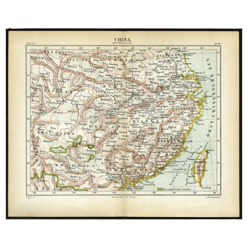
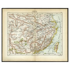
- Antique Map of Central and Southern China by Kuyper, 1880Located in Langweer, NLPlate 53 : 'China, Midden en Zuid.' (China, Central and South). This lithographed map originates from: 'Wereld-atlas voor Kantoor en Huiskamer' (transl: World Atlas for the office an...Category
Antique 19th Century Maps
MaterialsPaper
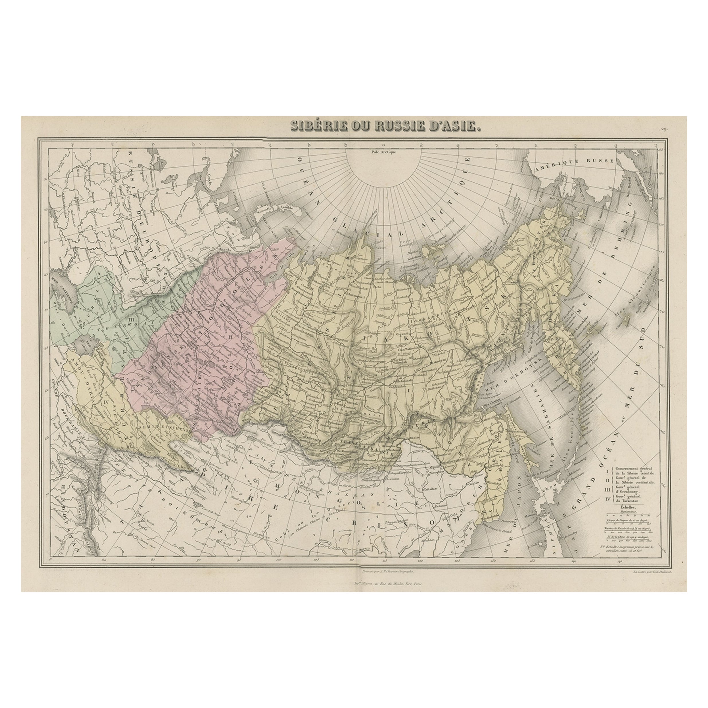
- Original Antique Map Covering the Russian Empire in Asia, 1880Located in Langweer, NLAntique map titled 'Sibérie ou Russie d'Asie'. Migeon's map covers the Russian empire in Asia from european Russia and the Ural Mountains to the Bering Strait and from the Arctic...Category
Antique 1880s Maps
MaterialsPaper
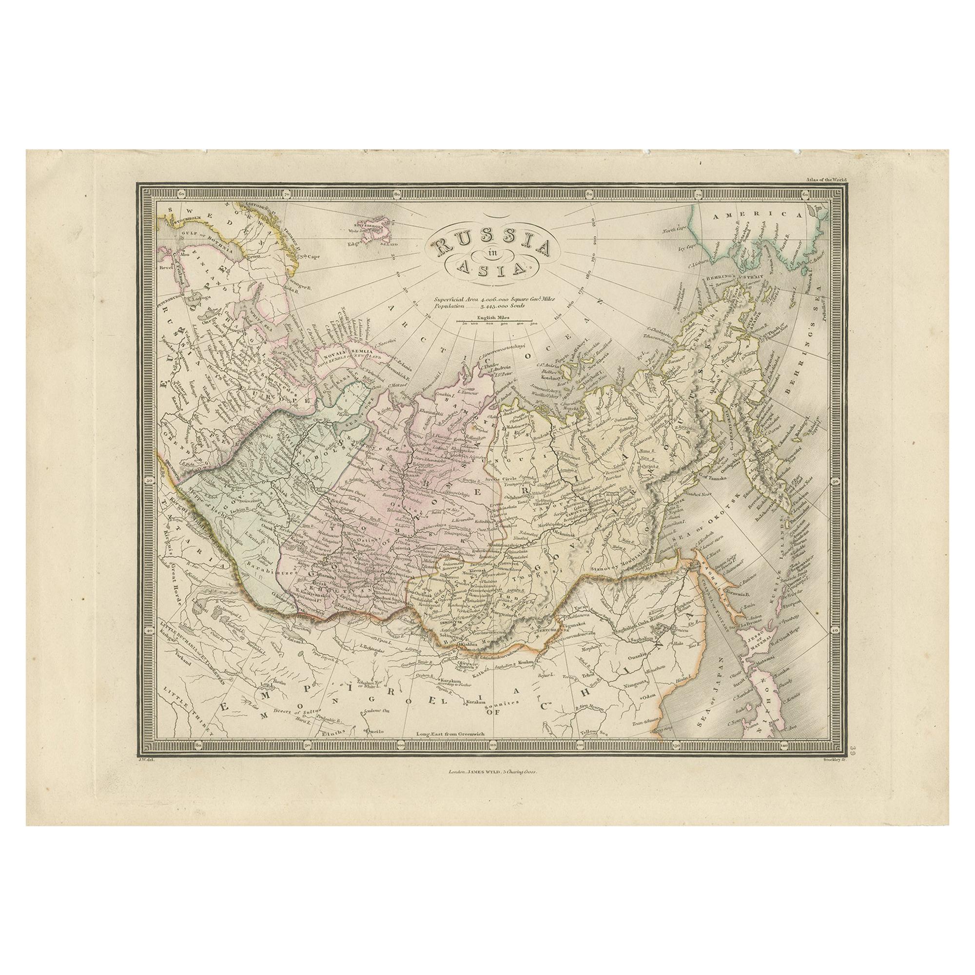
- Antique Map of Russia in Asia by Wyld, '1845'Located in Langweer, NLAntique map titled 'Russia in Asia'. Original antique map of Russia in Asia. This map originates from 'An Atlas of the World, Comprehending Separate Maps of its Various Countries, co...Category
Antique Mid-19th Century Maps
MaterialsPaper
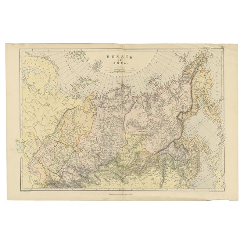
- Antique Map of Russia in Asia by Weller, 1882Located in Langweer, NLAntique map titled 'Russia in Asia'. Old map of Russia originating from Blackie's The Comprehensive Atlas & Geography of the World'. Artists and Engravers: Engraved by E. Weller. Pub...Category
Antique 19th Century Maps
MaterialsPaper

You May Also Like
- Original Antique Map of Asia. C.1780Located in St Annes, LancashireGreat map of Asia Copper-plate engraving Published C.1780 Two small worm holes to right side of map Unframed.Category
Antique Early 1800s English Georgian Maps
MaterialsPaper

- Original Antique Map of Russia By Arrowsmith. 1820Located in St Annes, LancashireGreat map of Russia Drawn under the direction of Arrowsmith Copper-plate engraving Published by Longman, Hurst, Rees, Orme and Brown, 1820 Unframed.Category
Antique 1820s English Maps
MaterialsPaper
- Original Antique Map of Cyprus. Circa 1880Located in St Annes, LancashireGreat map of Cyprus Drawn and Engraved by R.Walker Published W.Mackenzie, London Original colour Unframed.Category
Antique 1880s English Maps
MaterialsPaper
- Original Antique Map of South East Asia by Becker, circa 1840Located in St Annes, LancashireGreat map of South East Asia Steel engraving with original color outline Engraved by Becker Published by Virtue, circa 1840. Unframed.Category
Antique 1840s English Other Maps
MaterialsPaper
- Original Antique Map of South East Asia by Thomas Clerk, 1817Located in St Annes, LancashireGreat map of South East Asia Copper-plate engraving Drawn and engraved by Thomas Clerk, Edinburgh. Published by Mackenzie And Dent, 1817 Unframed.Category
Antique 1810s English Maps
MaterialsPaper
- Original Antique Map of South East Asia, Arrowsmith, 1820Located in St Annes, LancashireGreat map of South East Asia Drawn under the direction of Arrowsmith Copper-plate engraving Published by Longman, Hurst, Rees, Orme and Brown, 1820 Unframed.Category
Antique 1820s English Maps
MaterialsPaper


Recently Viewed
View AllMore Ways To Browse
Dutch 1880
Antique World Map Print
Jacobs Antique
Jacob Amsterdam
G Jacob
Antique Russian Wood Furniture
Antique Russian Wood
Antique Russian Map
Antique Map Room
Antique Map Russia
Antique Map Of Russia
Lake Decor
Antique Maps Of Russia
Russian Antique Plates
Old Asia Map
Small Antique Globes
Maps United Kingdom
Antique Surveying