Items Similar to Antique Map of Europe in the Middle Ages by Malte-Brun, 1850


Want more images or videos?
Request additional images or videos from the seller
1 of 5
Antique Map of Europe in the Middle Ages by Malte-Brun, 1850
About the Item
Antique map titled 'Géographie du Moyen Age principalement au IXe Siècle'. Early French map of Europe indicating the geography of Europe in the Middle Ages. This map originates from 'Atlas de la Geographie Universelle (.)'.
Artists and Engravers: Conrad Malte-Brun (1775-1826), Danish geographer born in Jutland, established himself in Paris in 1800. A geographer of considerable repute. His work was continued by his son Victor.
Condition: Good, general age-related toning. Minor wear, blank verso. Please study image carefully.
Date: c.1850
Overall size: 37.5 x 28 cm.
Image size: 0.001 x 31 x 22 cm.
- Dimensions:Height: 11.03 in (28 cm)Width: 14.77 in (37.5 cm)Depth: 0 in (0.01 mm)
- Materials and Techniques:
- Period:
- Date of Manufacture:circa 1850
- Condition:
- Seller Location:Langweer, NL
- Reference Number:
About the Seller
5.0
Platinum Seller
These expertly vetted sellers are 1stDibs' most experienced sellers and are rated highest by our customers.
Established in 2009
1stDibs seller since 2017
1,916 sales on 1stDibs
Typical response time: <1 hour
- ShippingRetrieving quote...Ships From: Langweer, Netherlands
- Return PolicyA return for this item may be initiated within 14 days of delivery.
More From This SellerView All
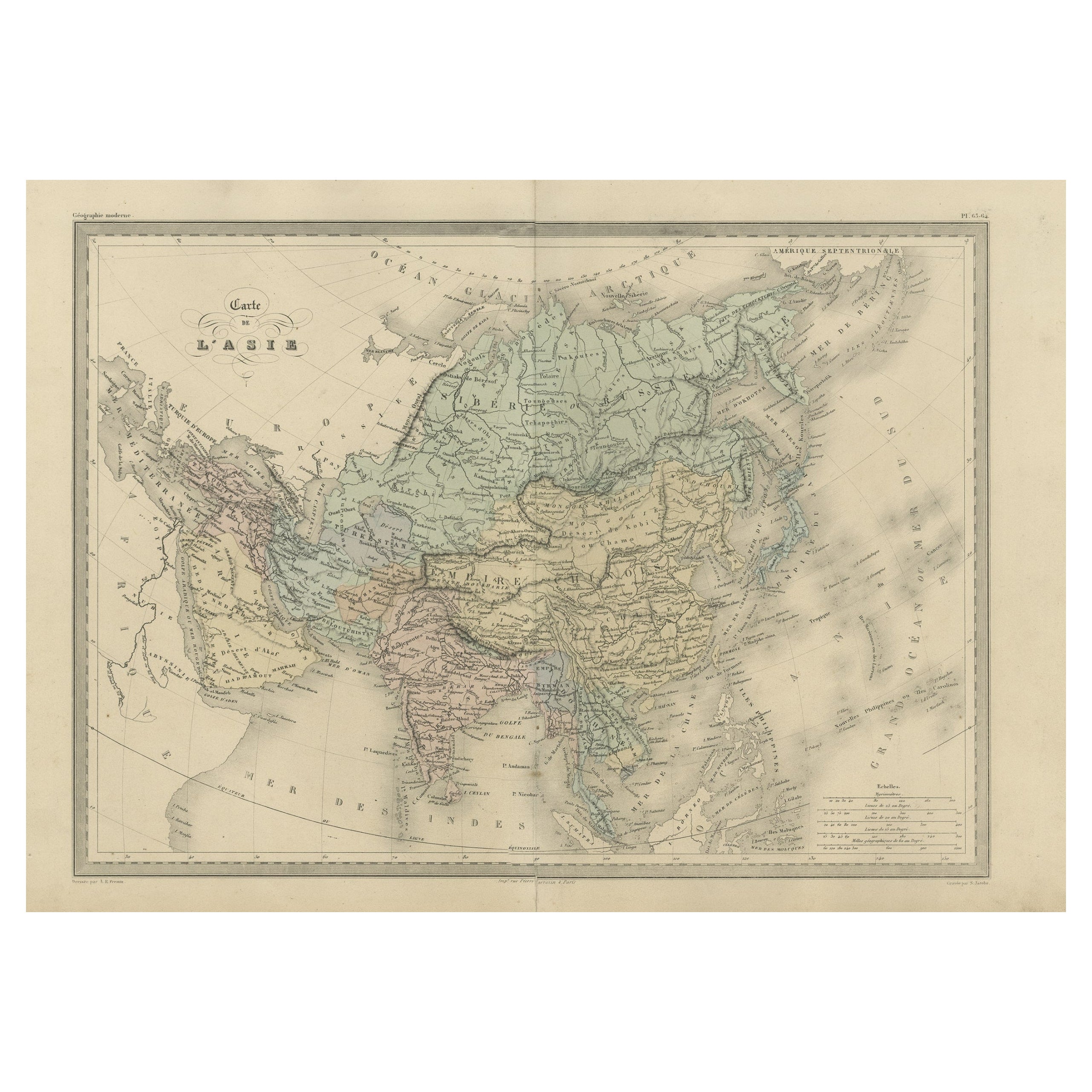
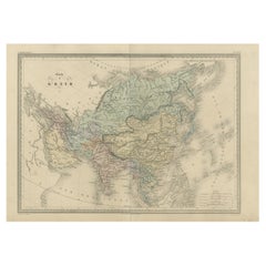
- Antique Map of Asia by Malte-Brun, 1880Located in Langweer, NLMap Pl. 63 - 64: 'Carte de l'Asie.' This map shows Asia. This original antique map originates from 'Atlas de la Geographie Universelle ou Description de toutes les parties du monde s...Category
Antique 19th Century Maps
MaterialsPaper
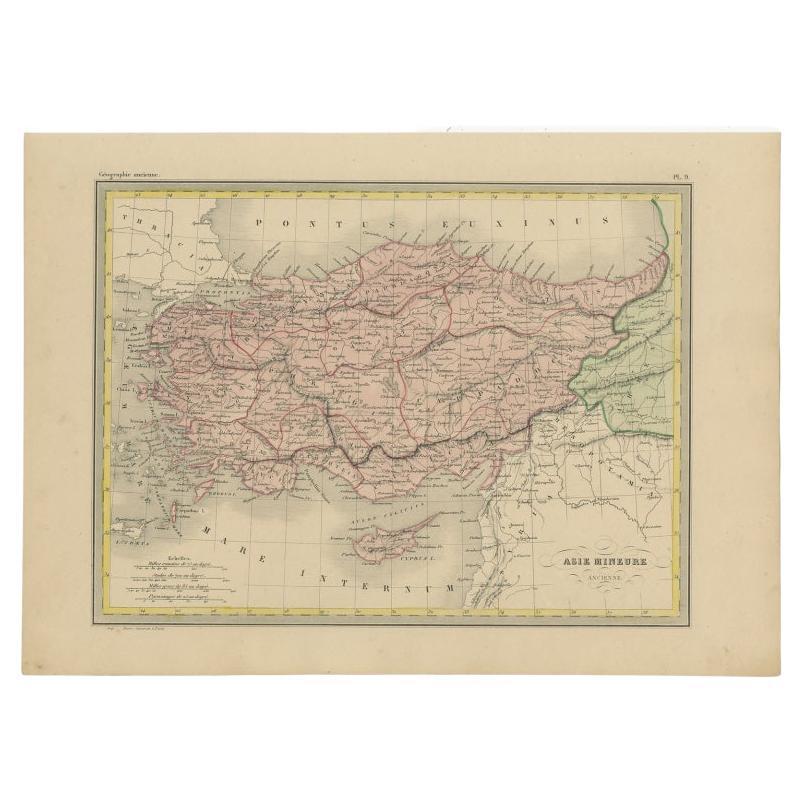
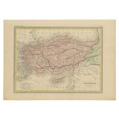
- Antique Map of Asia Minor by Malte-Brun, 1847Located in Langweer, NLAntique map titled 'Asie Mineure Ancienne'. This is an original antique map of Asia Minor from Malte Brun's "" Atlas de Géographie Universelle"", revised by...Category
Antique 19th Century Maps
MaterialsPaper
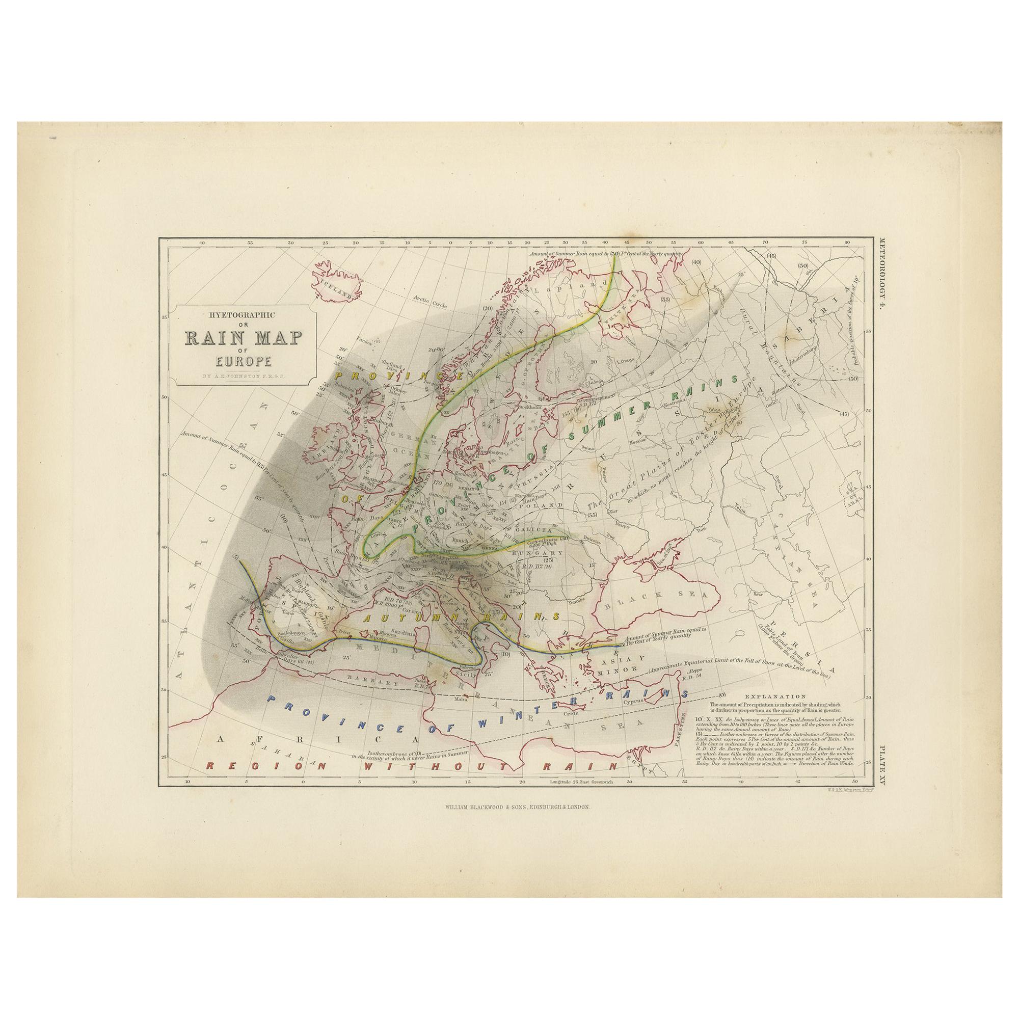
- Antique Rain Map of Europe by Johnston '1850'Located in Langweer, NLAntique map titled 'Hyetographic or Rain Map of Europe'. Original antique rain map of Europe. This map originates from 'The Physical Atlas of Natural Phenomena' by A.K. Johnston, pub...Category
Antique Mid-19th Century Maps
MaterialsPaper
- Antique Map of Russia 'in Europe' by W. & A.K. Johnston, circa 1850By W. & A.K. JohnstonLocated in Langweer, NLDetailed map of the region with a decorative piano key border. This map shows towns, railroads, rivers, lakes, mountains, railroad lines, Sub-oceanic Telegraph lines, etc.Category
Antique Mid-19th Century Maps
MaterialsPaper
- Antique Map of the Mountain Chains of Europe and Asia by Johnston '1850'Located in Langweer, NLAntique map titled 'The Mountain chains of the Europe and Asia '. Original antique map of the mountain chains of Europe and Asia. This map originates from 'The Physical Atlas of Natu...Category
Antique Mid-19th Century Maps
MaterialsPaper
- Antique Map of the River Systems of Europe and Asia by Johnston '1850'Located in Langweer, NLAntique map titled 'The River Systems of Europe and Asia showing the boundaries and comparative extent of the river basins'. Original antique map of the river systems of Europe and A...Category
Antique Mid-19th Century Maps
MaterialsPaper


You May Also Like
- Original Antique Map of Belgium by Tallis, Circa 1850Located in St Annes, LancashireGreat map of Belgium Steel engraving Many lovely vignettes Published by London Printing & Publishing Co. ( Formerly Tallis ), C.1850 Origin...Category
Antique 1850s English Maps
MaterialsPaper
- Antique Hand Colored Framed Map of EuropeLocated in West Palm Beach, FLAntique reproduction copied from an edition dated 1595 by Ortelius.Category
Antique Late 19th Century Maps
- Large Original Antique Map of Europe by Sidney Hall, 1847Located in St Annes, LancashireGreat map of Europe Drawn and engraved by Sidney Hall Steel engraving Original colour outline Published by A & C Black. 1847 Unframed Free shipping.Category
Antique 1840s Scottish Maps
MaterialsPaper
- 1861 Topographical Map of the District of Columbia, by Boschke, Antique MapLocated in Colorado Springs, COPresented is an original map of Albert Boschke's extremely sought-after "Topographical Map of the District of Columbia Surveyed in the Years 1856 ...Category
Antique 1860s American Historical Memorabilia
MaterialsPaper
- Metropolitan Museum of Art: Europe in the Age of Monarchy, 1st EdLocated in valatie, NYThe Metropolitan Museum of Art: Europe in the Age of Monarchy. Published by The Metropolitan Museum of Art, 1987, NY. 1st Ed hardcover. The seventeenth century in Europe rings with the names of the great sovereigns who had succeeded in creating nations by subjugating the feudal aristocracy and at whose courts power and wealth were concentrated and the arts flourished. Elizabeth I of England secured for her heirs the Protestant succession and for her country mastery of the seas; Louis XIV of France assembled his defeated vassals at Versailles; Gustavus II Adolphus and Christina of Sweden were for a time the most powerful Protestant monarchs on the Continent; Philip III and Philip IV...Category
Vintage 1980s American Books
MaterialsPaper
- The Last Flowering of the Middle Ages by Baron Van Der Elst, Stated 1st EdLocated in valatie, NYThe Last Flowering of the Middle Ages by Baron Joseph Van Der Elst. Published by Doubleday, Doran and Company Inc., 1944. Stated 1st Ed hardcover. An in-depth look into art of the Middle Ages. Contents: 1. The Times and the Men who Made Them: Men of Flanders; The Flemish Parade; The Good Black Earth; The Rise of the Towns; The Medieval Guilds; Of Love, the Dream; The Upward Glance; Pt. 2. The Flemish Masters: Jan van Eyck; Petrus Christus...Category
Vintage 1940s American Books
MaterialsPaper