Items Similar to Antique Rain Map of Europe by Johnston '1850'


Want more images or videos?
Request additional images or videos from the seller
1 of 5
Antique Rain Map of Europe by Johnston '1850'
About the Item
Antique map titled 'Hyetographic or Rain Map of Europe'. Original antique rain map of Europe. This map originates from 'The Physical Atlas of Natural Phenomena' by A.K. Johnston, published 1850.
- Dimensions:Height: 11.03 in (28 cm)Width: 14.18 in (36 cm)Depth: 0.02 in (0.5 mm)
- Materials and Techniques:
- Period:
- Date of Manufacture:1850
- Condition:General age-related toning. Minor wear, blank verso. Please study image carefully.
- Seller Location:Langweer, NL
- Reference Number:
About the Seller
5.0
Platinum Seller
These expertly vetted sellers are 1stDibs' most experienced sellers and are rated highest by our customers.
Established in 2009
1stDibs seller since 2017
1,947 sales on 1stDibs
Typical response time: <1 hour
- ShippingRetrieving quote...Ships From: Langweer, Netherlands
- Return PolicyA return for this item may be initiated within 14 days of delivery.
More From This SellerView All
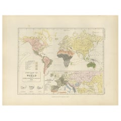
- Antique Rain Map of the World by Johnston '1850'Located in Langweer, NLAntique map titled 'Hyetographic or Rain Map of the World'. Original antique rain map of the world. This map originates from 'The Physical Atlas of Natural Phenomena' by A.K. Johnsto...Category
Antique Mid-19th Century Maps
MaterialsPaper
- Antique Map of Russia 'in Europe' by W. & A.K. Johnston, circa 1850By W. & A.K. JohnstonLocated in Langweer, NLDetailed map of the region with a decorative piano key border. This map shows towns, railroads, rivers, lakes, mountains, railroad lines, Sub-oceanic Telegraph lines, etc.Category
Antique Mid-19th Century Maps
MaterialsPaper
- Antique Map of the Mountain Chains of Europe and Asia by Johnston '1850'Located in Langweer, NLAntique map titled 'The Mountain chains of the Europe and Asia '. Original antique map of the mountain chains of Europe and Asia. This map originates from 'The Physical Atlas of Natu...Category
Antique Mid-19th Century Maps
MaterialsPaper
- Antique Map of the River Systems of Europe and Asia by Johnston '1850'Located in Langweer, NLAntique map titled 'The River Systems of Europe and Asia showing the boundaries and comparative extent of the river basins'. Original antique map of the river systems of Europe and A...Category
Antique Mid-19th Century Maps
MaterialsPaper
- Antique Geological Map of the World by Johnston '1850'Located in Langweer, NLAntique map titled 'The Geological Structure of the Globe'. Original antique geological map of the world. This map originates from 'The Physica...Category
Antique Mid-19th Century Maps
MaterialsPaper
- Antique Ethnographic Map of the World by Johnston '1850'Located in Langweer, NLAntique map titled 'Ethnographic map of the world showing the present distribution of the leading races of man'. Original antique ethnographic map...Category
Antique Mid-19th Century Maps
MaterialsPaper


You May Also Like
- Original Antique Map of Belgium by Tallis, Circa 1850Located in St Annes, LancashireGreat map of Belgium Steel engraving Many lovely vignettes Published by London Printing & Publishing Co. ( Formerly Tallis ), C.1850 Origin...Category
Antique 1850s English Maps
MaterialsPaper
- Original Antique Map of Europe, Arrowsmith, 1820Located in St Annes, LancashireGreat map of Europe Drawn under the direction of Arrowsmith. Copper-plate engraving. Published by Longman, Hurst, Rees, Orme and Brown, 1820 ...Category
Antique 1820s English Maps
MaterialsPaper
- Original Antique Map / City Plan of Brussels by Tallis, circa 1850Located in St Annes, LancashireGreat map of Brussels. Steel engraving. Published by London Printing & Publishing Co. (Formerly Tallis), C.1850 Free shipping.Category
Antique 1850s English Maps
MaterialsPaper
- Antique Map of Italy by Andriveau-Goujon, 1843By Andriveau-GoujonLocated in New York, NYAntique Map of Italy by Andriveau-Goujon, 1843. Map of Italy in two parts by Andriveau-Goujon for the Library of Prince Carini at Palazzo Carini i...Category
Antique 1840s French Maps
MaterialsLinen, Paper
- Antique Map of Principality of MonacoBy Antonio Vallardi EditoreLocated in Alessandria, PiemonteST/619 - "Old Geographical Atlas of Italy - Topographic map of ex-Principality of Monaco" - ediz Vallardi - Milano - A somewhat special edition ---Category
Antique Late 19th Century Italian Other Prints
MaterialsPaper
- Original Antique Map of Russia By Arrowsmith. 1820Located in St Annes, LancashireGreat map of Russia Drawn under the direction of Arrowsmith Copper-plate engraving Published by Longman, Hurst, Rees, Orme and Brown, 1820 Unframed.Category
Antique 1820s English Maps
MaterialsPaper


Recently Viewed
View AllMore Ways To Browse
Antique European Maps
Antique European Map
Antique Maps Europe Maps
Europe Map Antique
Antique Europe Map
Antique Maps Of Europe
Antique Map Europe
Antique Map Of Europe
Antique Map Engraving
Antique City Maps
Antique City Map
Antique Maps Of Cities
England Map
Antique World Maps And Atlases World Maps
Antique Furniture Portugal
Map Of England
Original City Map
Antique Furniture Edinburgh