Items Similar to A truly delightful miniature terrestrial pocket globe


Want more images or videos?
Request additional images or videos from the seller
1 of 9
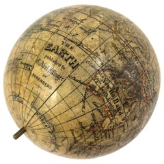
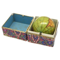
A truly delightful miniature terrestrial pocket globe
About the Item
A truly delightful miniature terrestrial pocket globe in a celestial case, 3 inches / 6.8 cm. The globe consists of 12 wonderful varnished, engraved hand-coloured gores that stretch from pole to pole. In the original case of black fish-skin with a brass hinge and two brass hook-and-eyelet closures, case with a unique silver plaque which reads:
"B. Bellchamber S. King - Gul's Fox Summum Geographicum Praemium Pares Meruere". *
[This very roughly translates to:]
"B. Bellchamber S. King - Gul's Fox Earns Top Geographical Peers Award".
*Is it too much to suppose and speculate that this wonderful silver plaque attached to the outer case is in recognition of a [geographic?] scholastic achievement? The prize awarded to the lucky recipients (B. Bellchamber & S. King?) is this globe?
This terrestrial globe has two repairs; to the area concerning the British Isles, and also to parts of Europe and Scandinavia (with some loss). There is some slight loss to a portion of North America, and there is a crack to the northern portion of South America. It is partly worn in other places and has some slight spotting. It is lacking the axis metal pin, and the two holes that normally allow for this pin have been closed. The case is split and segmented, partly rubbed and worn with cracks, (as is usual.) The case will close. There is some minor chipping and cracking to the outer rim of the inside of the case.
About Pocket Globes.
It is generally thought that Joseph Moxon brought pocket globes to England in the late seventeenth century. These globes usually consist of a terrestrial sphere of about 7.5 cm in diameter that fits into an outer case (usually made of fish-skin). The interior of this case often bears bright, colourful celestial cartography, so you effectively have the celestial heavens surrounding the terrestrial earth.
Pocket globes, although highly desirable, are for all intents and purposes somewhat impractical, as their size makes accurate calculations impossible. Few, if any, pocket globes came with accompanying booklets, so it is hard for anyone to know who used them and for what purposes.
Pocket globes could simply have served purely as status symbols for wealthy gentlemen, who had an interest in geography or astronomy. The fields of geography and the sciences were quickly advancing during this period. Alternatively, pocket globes could be seen as a tool used in children’s education, especially when you think that they are construction from cheap materials such as papier-mâché.
Points of Interest.
This particular globe shows California as a peninsula, whereas previously it had been depicted as an island – a misconception dating back to the sixteenth century; it has the northwest coast of America simply as "unknown parts."; - due to a profound lack of knowledge of the region; the track of Admiral George Anson’s circumnavigation of the world (1740-44) is drawn – Anson led a squadron of eight ships on a mission to disrupt or capture the Pacific Ocean possessions of the Spanish Empire, for emphases, the trade winds are indicated by red arrows. There are three large lakes engraved in Africa that may longer exist.
The Celestial Gores.
The celestial gores, housed within the case, are fun and eye-catching both in their display and in their content. Constellations and both hemispheres and are represented.
Gemini, Cancer, Virgo, Orion, Andromeda, Taurus, Leo, Ursa Major etc in the north, and Scorpio, Libra, Canis Major etc in the south.
A celestial globe is a mapping of the stars, and has been used since classical times. Celestial globes were first used by Greek astronomers, and later by the Islamic world, where the earliest known globes date from the eleventh century. The stars were thought to sit on the surface of a giant sphere around the earth, and the constant movement of the stars each night and throughout the year appeared to be caused by this giant sphere slowly turning overhead. In line with its counterpart, the terrestrial globe, celestial globes are mapped by a north and a south pole, an equator, and lines of latitude and longitude.
The Terrestrial Globe.
The North Pole encompasses the Arctic Circle, Baffin Bay (Canada), Iceland, Greenland, northern Siberia and Nuova Zembla.
Europe shows the Dominion of Muscovy (a principality of the late Middle Ages centered on Moscow), Turkey, the British Isles, Italy etc.
Africa highlights the Barbary coast, Biledulgerid (a former country in North Africa), the Zaara Desart (Sahara Desert), Negroland (an archaic term in European mapping referring to large portions of West Africa), Guinea, Ethiopia, Congo, the islands of the Azores and the Canaries.
Australia (New Holland) shows the outdated cartography of an incomplete coastline; The West Australian and Northern Territory coastlines are in full, however, there is no connected mainland coastline from South Australia up to Northern Queensland. Papua New Guinea is still thought to be a part of the Australian mainland. A portion of Tasmania’s coastline is engraved. The only places/regions mentioned are: Dimens Land and Carpentaria in the north; Lewins, St. Francis, Mary’s Island, South Cape, and Dimens Land in the south.
Interestingly, a place named Hartog’s Island is mentioned off the West Australian coast. This island has a unique place within Australia’s history as it is the first recorded European landing on Australian soil in 1616 by the island’s namesake, Dutch captain Dirk Hartog – fully 150 years before Capt. James Cook officially discovered Australia for Great Britain.
The continent of Asia depicts Independent Tartary, Great Tartary & Chinese Tartary (a European blanket term for the region the Caspian Sea the Ural Mountains and the Pacific Ocean), Persia, India, Ceylon, Arabia, Pegu, Siam, China, Japan, Borneo, Sumatra, Java, The Philippines, and the Celebes. The South Pole is a sparce area with only minimal cartography; the Antarctic Circle, the Ice Sea, The Southern Ocean, the southerly tips of Australia, New Zealand, and South America.
North America shows California, New Mexico, Mexico or New Spain, Virginia, Maryland, Carolina, Georgia, Florida, Illinois, and New England. The Mississippi the North and the Long River are all indicated. Canada has the humorous “Unknown Parts”, New Britain, Hudson’s Bay, Lake Superior, New South Wales (!), Hurons, the Laurence River.
South America features Venezuela, Guiana, ‘Terra Firma’, Amazones, the Amazon River, Lake Zaraies (Xaraies or Lake Parime – the supposed location of the fabled city of gold EL DORADO!), Lima, Peru, La Plata, Patagonia, Brazil, and Chile. It names Quito, Lima, St. Catherine’s Island, the River Plate, Tucama, Magellan’s Strait. There is some attempt at border delineation.
Central America and the Caribbean are well represented with Bermuda, Jamaica, Cuba, Barbados, the Antilles Islands etc.
The various oceans are all provided with wind arrows - highlighting the prevailing trade winds. The Atlantic is blessed with the delightful rococo style title cartouche. The Pacific indicates numerous islands, both large and small. The track of Anson’s voyage is highlighted in colour and marked by dotted lines.
Background information on Nathaniel Hill.
It is safe to say that Nat Hill (fl. 1746-1748) had impeccable credentials and was one of the most sort after English globe makers of the mid eighteenth century. From 1731 he was apprenticed to the map maker, publisher, surveyor and globe maker Richard Cushee (1696-ca.1734) who operated ‘at the sign of The Globe & Sun’ between Chancery Lane and St. Dunstan’s Church in London. Hill worked initially as a surveyor on the Yorkshire Fens. He eventually became a maker of globes and mathematical instruments.
- Creator:Nathaniel Mills (Maker)
- Dimensions:Height: 2 in (5.08 cm)Diameter: 3 in (7.62 cm)
- Style:Dutch Colonial (Of the Period)
- Materials and Techniques:
- Place of Origin:
- Period:
- Date of Manufacture:1754
- Condition:
- Seller Location:ZWIJNDRECHT, NL
- Reference Number:1stDibs: LU9419237706132
About the Seller
New to 1stDibs
Joined in the past six months.
No Reviews Yet
Vetted Seller
These experienced sellers undergo a comprehensive evaluation by our team of in-house experts.
1stDibs seller since 2023
- ShippingRetrieving quote...Ships From: ZWIJNDRECHT, Netherlands
- Return PolicyA return for this item may be initiated within 14 days of delivery.
More From This SellerView All
- Miniature pocket globe in colourful card boxBy Michael ManningLocated in ZWIJNDRECHT, NLMiniature terrestrial pocket globe. Model of the earth. London, 1857 by J. Manning diameter of 1,75 inches / 4,5 cm. This lovely miniature terrestrial globe consists of twelve copp...Category
Antique 19th Century British Early Victorian Globes
MaterialsHardwood, Paper
- Fine double pocket globeBy Carl BauerLocated in ZWIJNDRECHT, NLPublisher: Carl Bauer (Germany, 1780-1857) Place / Date: Nürnberg, ca. 1840 Size: Diameter Globes 6,5 cm. Terrestrial and celestial "Mother and Child" or double globe; the ...Category
Antique 1840s German Dutch Colonial Globes
MaterialsWood, Paper

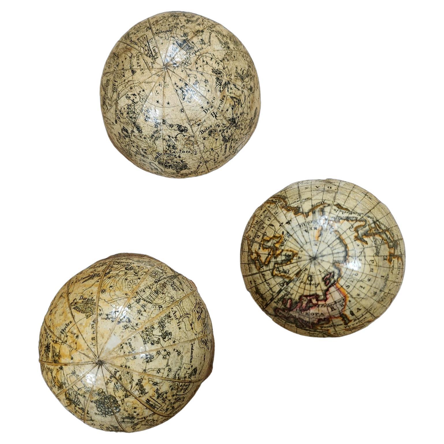
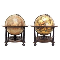
- An extremely rare pair of miniature globes by Johann Baptist HomannBy Johann Baptist HomannLocated in ZWIJNDRECHT, NLJ.H. Homann (Germany, 1664-1724) Nürnberg, after 1715 Globus Terrestris [and] Globus Celestis. juxtu observationes Parisienses Regia Academia Scientiarum constructus [and] juxtu observationes Parisienses Regia Academia Scientiarum constructus. Nuremberg, [after 1715]. Original stands by Homann Heirs, [after 1730]. An extremely rare pair of terrestrial and celestial globes, each with 12 hand-coloured engraved paper gores, over a papier mâché and plaster sphere, each globe with papier mâché meridian ring, mounted on horizon rings with a handwritten number VIII and III on each globe. The horizon rings supported by four quadrants with text "Zu finden in Nürnberg / wohnhaft unter der Vesten / bey denen Homaenischen Erben/ dem Prediger Klöster gegenüber", both globes on a turned single wooden black stand. Diameter 64 mm (2.5 inches), height 185 mm. RARE. Johann Baptist Homann (1664–1724), a German geographer and cartographer. He founded a publishing business in Nürnberg in 1702, and published his first atlas in 1707, becoming a member of the Academy of Sciences in Berlin in the same year. Homann was appointed Imperial Geographer to Charles VI in 1715 and became the most important map...Category
Antique 1710s German Dutch Colonial Globes
MaterialsOther
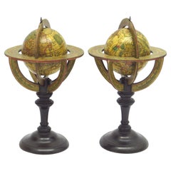
- A fine pair of miniature globes on standsBy Karl MullerLocated in ZWIJNDRECHT, NLA rare pair of miniature terrestrial and celestial globes. by K. Müller, 1822 Karlsruhe, Germany Diameter globes: 7 cm. Total high: 14,5 cm. Each with 12 hand-coloured engraved p...Category
Antique Early 19th Century German International Style Globes
MaterialsHardwood, Paper
- Miniature globe in aturned and stained beechBy Newton and SonLocated in ZWIJNDRECHT, NLNewton & Son pocket globe London, 1838 Miniature terrestrial globe with a diameter of 2 inches / 5 cm. In a turned and stained beech two-section case, 3,95 inches / 10 cm. high.Category
Antique 19th Century British Late Victorian Globes
MaterialsFruitwood, Paper
- A pair of extremely rare Valk table globesBy Gerard and Leonard ValkLocated in ZWIJNDRECHT, NLTitle on the globes: VALK, Gerard and Leonard. [Terrestrial globe:] Cosmotheore, caelesti nostro globo, par, et plane novus, hic terrestris ut existeret, certo scias, errore veterum ...Category
Antique 18th Century Dutch Dutch Colonial Globes
MaterialsOther
You May Also Like
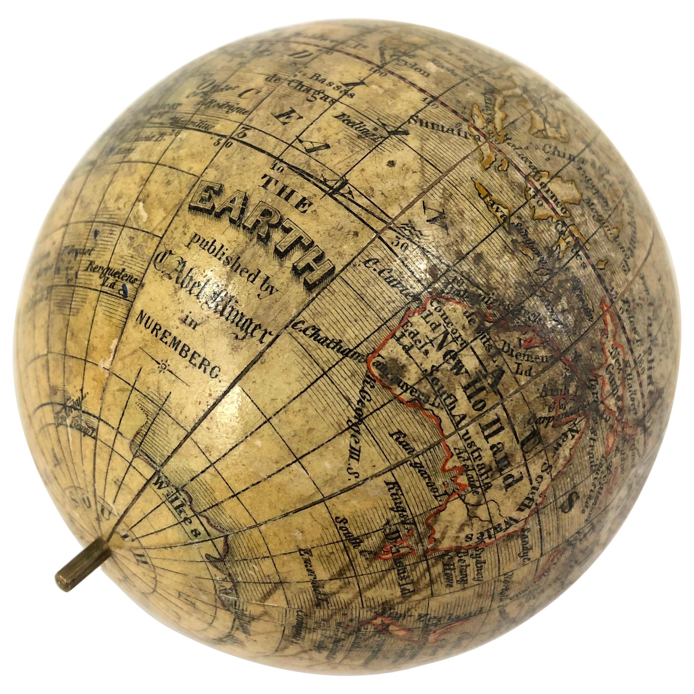
- 19th Century German Miniature Pocket Terrestrial GlobeBy C. Abel-KlingerLocated in Essex, MAA miniature 19th century 3.5 inch diameter pocket terrestrial globe by C. Abel-Klinger, Nuremberg, Germany, in English for the English speaking markets. Signed with cartouche reading...Category
Antique 1880s German Scientific Instruments
MaterialsBrass
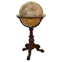
- Large Terrestrial Library GlobeLocated in Nashville, TN30 inch diameter library globe featuring Oklahoma with Indian territory, circa 1890. Maker is Johnston, Edinburgh, Scotland, a renowned British globe pro...Category
Antique Late 19th Century Scottish Globes
MaterialsBrass
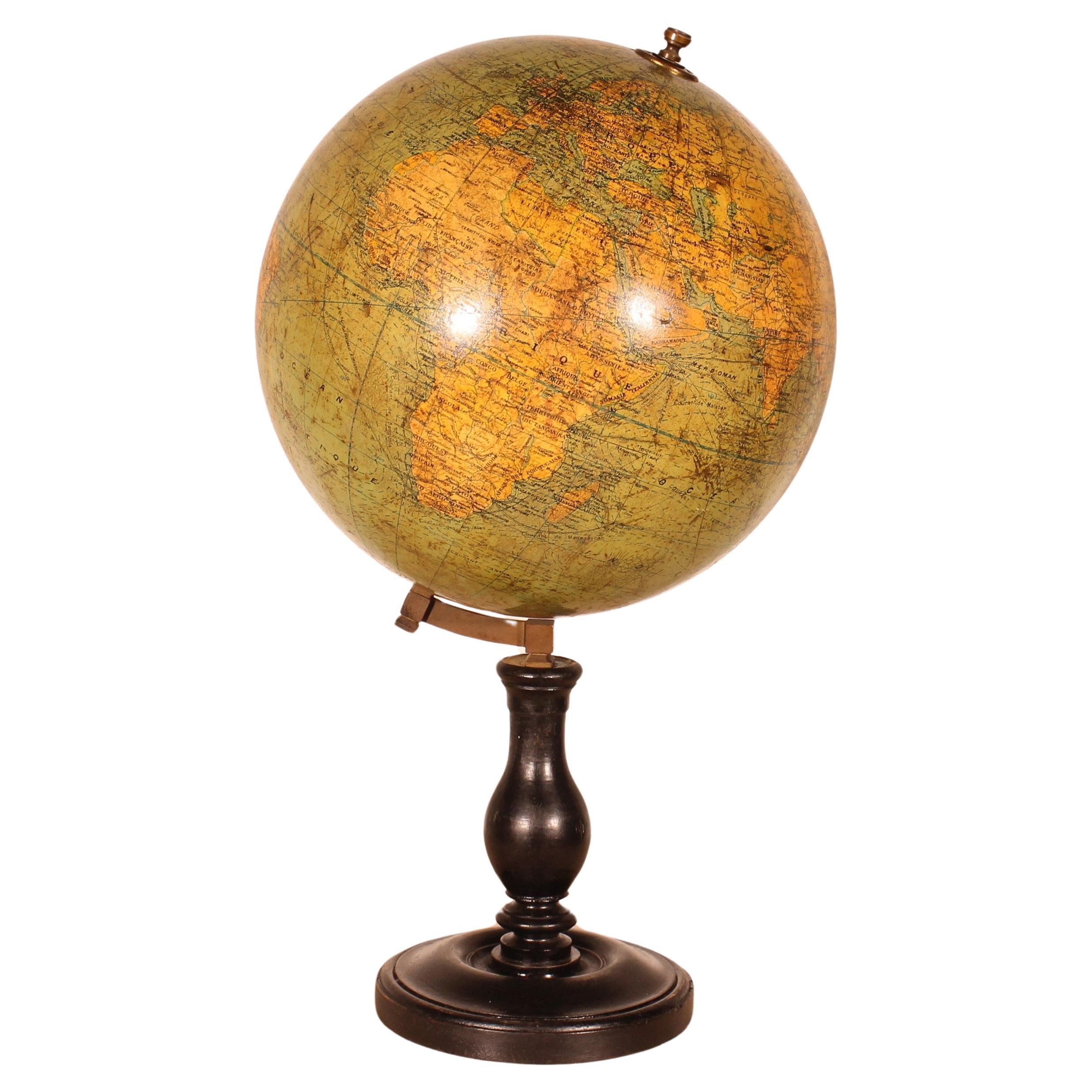
- Terrestrial Globe By G. ThomasLocated in Brussels, BrusselsVery beautiful Terrestrial Globe from the beginning of the 20th century circa 1910 by G.Thomas publisher Paris The Terrestrial Globe has a very beautiful blackened wooden base with ...Category
Early 20th Century French Napoleon III Globes
MaterialsPaper
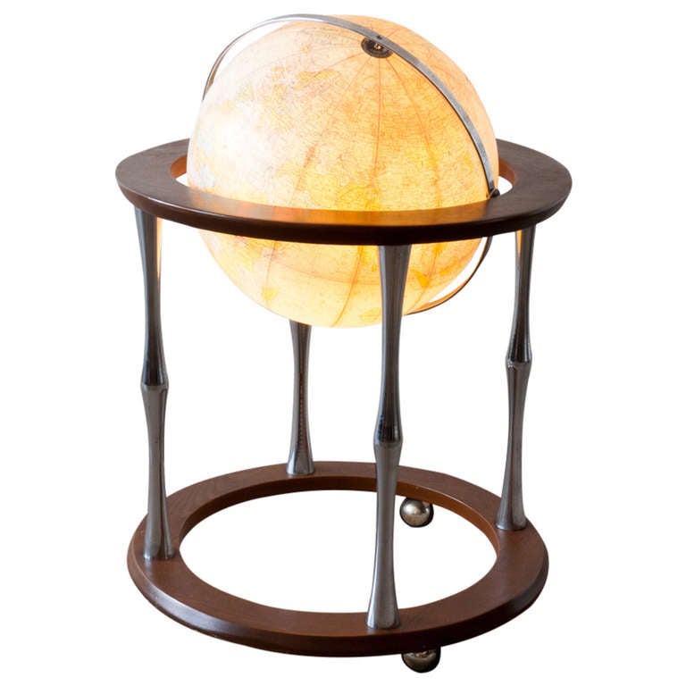
- Replogle Terrestrial Floor GlobeBy Replogle GlobesLocated in Asbury Park, NJThis floor globe by Replogle floats within a ring of walnut, supported by four 'turned' chrome stiles, which connect to a base of walnut. The ...Category
Vintage 1960s American Mid-Century Modern Globes
- Terrestrial Globe By PhilipsLocated in Brussels, BrusselsVery beautiful Terrestrial Globe made by Philips Londre based on the maps of Taride Paris Boulevard Saint Germain The Terrestrial Globe has a very beautiful cast iron base decorated...Category
20th Century British Napoleon III Globes
MaterialsPaper
- 1900 Terrestrial Floor GlobeLocated in Brooklyn, NYTerrestrial floor globe with a large cartouche to the Pacific Ocean, supported in a graduated brass meridian with a mahogany horizon band with paper zodiac and calendar. Globe raised...Category
Antique Early 1900s Globes
MaterialsMahogany