Items Similar to Antique Map of the Eastern Hemisphere by Wyld, 1842


Want more images or videos?
Request additional images or videos from the seller
1 of 5
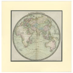
Antique Map of the Eastern Hemisphere by Wyld, 1842
About the Item
Antique map titled 'Eastern Hemisphere'. Large map depicting the continents Europe, Asia, Afrika and Australia.
Artists and Engravers: James Wyld (1812–1887) was a British geographer and map-seller, best known for Wyld's 'Great Globe'.
Condition: Good, minor wear. Split along folding line, please study image carefully.
Date: 1842
Overall size: 59.5 x 71.5 cm.
Image size: 58.5 x 58 cm.
We sell original antique maps to collectors, historians, educators and interior decorators all over the world. Our collection includes a wide range of authentic antique maps from the 16th to the 20th centuries. Buying and collecting antique maps is a tradition that goes back hundreds of years. Antique maps have proved a richly rewarding investment over the past decade, thanks to a growing appreciation of their unique historical appeal. Today the decorative qualities of antique maps are widely recognized by interior designers who appreciate their beauty and design flexibility. Depending on the individual map, presentation, and context, a rare or antique map can be modern, traditional, abstract, figurative, serious or whimsical. We offer a wide range of authentic antique maps for any budget
- Dimensions:Height: 28.15 in (71.5 cm)Width: 23.43 in (59.5 cm)Depth: 0 in (0.01 mm)
- Materials and Techniques:
- Period:
- Date of Manufacture:1842
- Condition:Condition: Good, minor wear. Split along folding line, please study image carefully.
- Seller Location:Langweer, NL
- Reference Number:
About the Seller
5.0
Platinum Seller
These expertly vetted sellers are 1stDibs' most experienced sellers and are rated highest by our customers.
Established in 2009
1stDibs seller since 2017
1,928 sales on 1stDibs
Typical response time: <1 hour
- ShippingRetrieving quote...Ships From: Langweer, Netherlands
- Return PolicyA return for this item may be initiated within 14 days of delivery.
More From This SellerView All
- Antique Map of the Eastern Hemisphere by Wyld '1845'Located in Langweer, NLAntique map titled 'Eastern Hemisphere'. Original antique map of the eastern hemisphere. This map originates from 'An Atlas of the World, Comprehending Separate Maps of its...Category
Antique Mid-19th Century Maps
MaterialsPaper
- Antique Map of the Western Hemisphere by Wyld '1845'Located in Langweer, NLAntique map titled 'Western Hemisphere'. Original antique map of the western hemisphere. This map originates from 'An Atlas of the World, Comprehending Separate Maps of its...Category
Antique Mid-19th Century Maps
MaterialsPaper
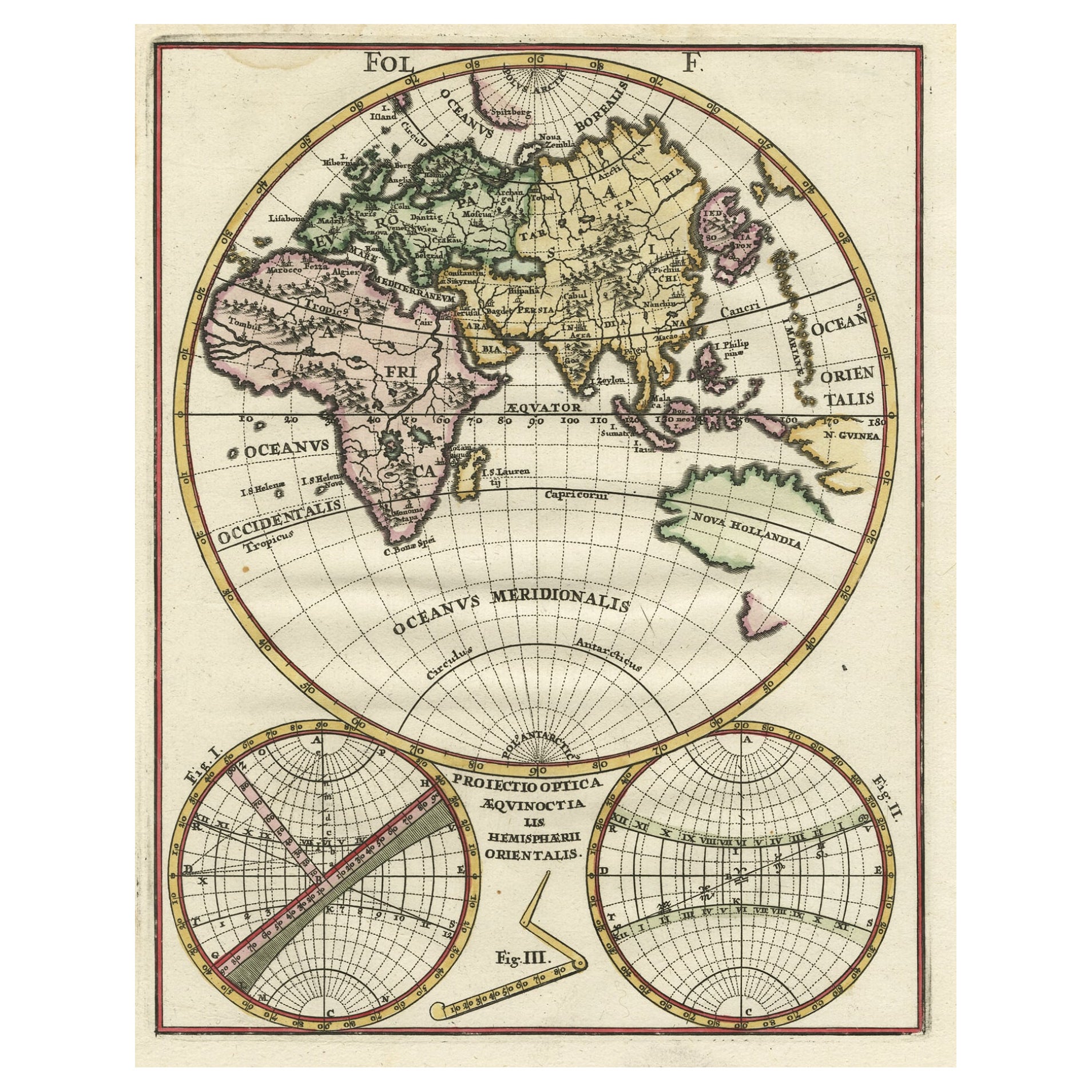
- Original Antique Engraving of the Eastern Hemisphere, c.1700Located in Langweer, NLAntique map titled 'Proiectio Optica Aequinoctia lis Hemishaerii Orientalis' - Map of the Eastern Hemisphere with Africa, Europe, Asia and Nova Hollandia...Category
Antique 17th Century Maps
MaterialsPaper
- Antique Map of a Hemisphere by Scherer, c.1703Located in Langweer, NLAntique map depiciting a horizon/hemisphere. Printed for Scherer's 'Atlas Novus' (1702-1710). Artists and Engravers: Heinrich Scherer (1628-1704) was a Professor of Hebrew, Mathematics and Ethics at the University of Dillingen until about 1680. Thereafter he obtained important positions as Official Tutor to the Royal Princes...Category
Antique 18th Century Maps
MaterialsPaper
- Antique Map of South America by Wyld, circa 1850By J. WyldLocated in Langweer, NLBeautiful folding map of South America titled 'Colombia Prima or South America Drawn from the Large Map in Eight Sheets by Louis Stanislas D ' Arcy Delarochette'. Three insets in the...Category
Antique Mid-19th Century British Maps
MaterialsPaper
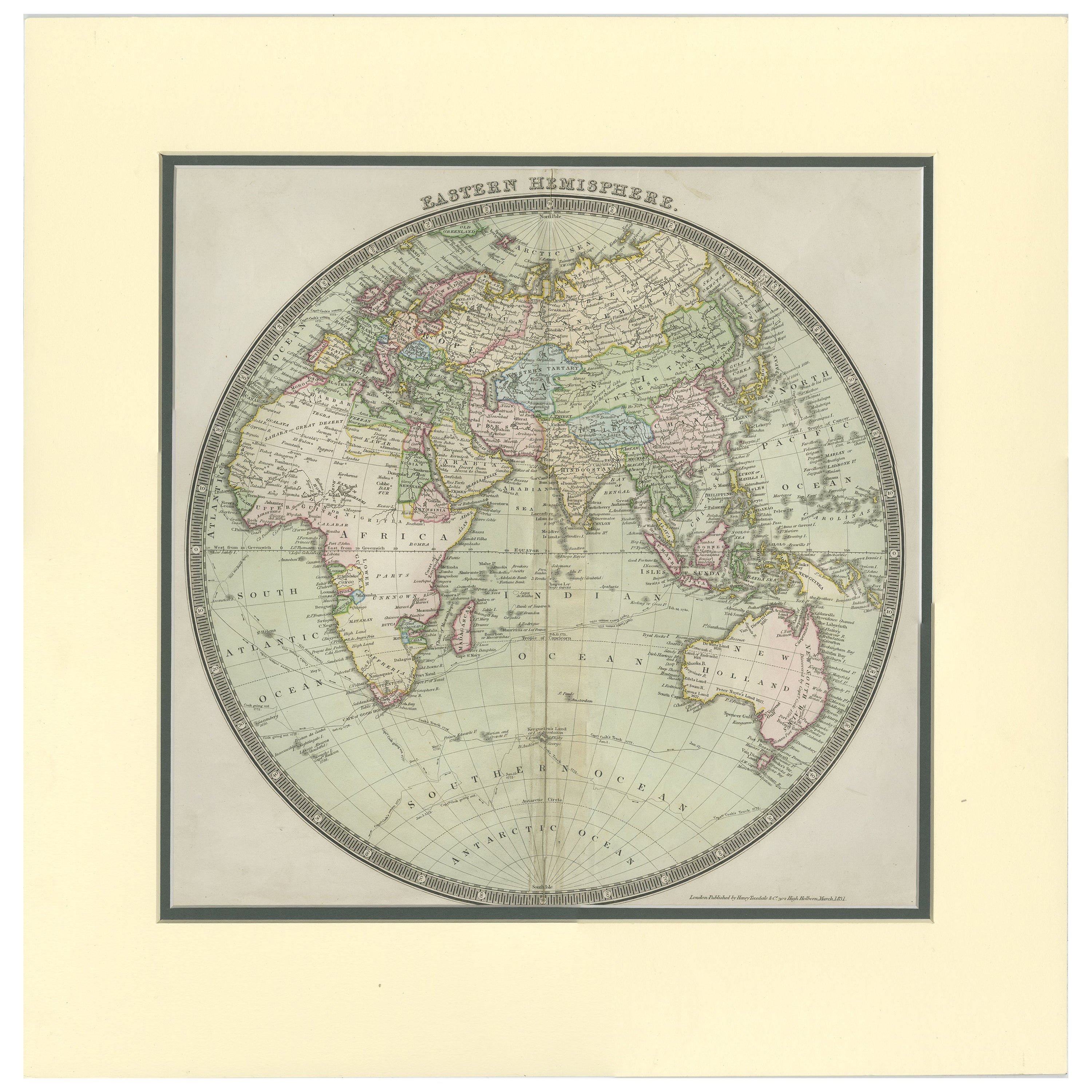
- Antique Map of the Eastern Hemisphere by Teesdale, '1831'Located in Langweer, NLAntique map titled 'Eastern Hemisphere'. Hemispherical map of eastern hemisphere showing tracks of the navigators James Cook and John Gore. Plate 1 fro...Category
Antique Mid-19th Century Maps
MaterialsPaper


You May Also Like
- Large Original Vintage Map of the South Eastern States Inc. Florida, circa 1920Located in St Annes, LancashireGreat map of The South Eastern States Original color. Good condition Published by Alexander Gross Unframed.Category
Vintage 1920s English Maps
MaterialsPaper
- Original Antique Map of the American State of Washington, 1889Located in St Annes, LancashireGreat map of Washington Drawn and Engraved by W. & A.K. Johnston Published By A & C Black, Edinburgh. Original colour Unframed.Category
Antique 1880s Scottish Victorian Maps
MaterialsPaper
- Original Antique Map of the American State of Nevada, 1889Located in St Annes, LancashireGreat map of Nevada Drawn and Engraved by W. & A.K. Johnston Published By A & C Black, Edinburgh. Original colour Unframed.Category
Antique 1880s Scottish Victorian Maps
MaterialsPaper
- Original Antique Map of the American State of Oregon, 1889Located in St Annes, LancashireGreat map of Oregon Drawn and Engraved by W. & A.K. Johnston Published By A & C Black, Edinburgh. Original colour Unframed.Category
Antique 1880s Scottish Victorian Maps
MaterialsPaper
- Original Antique Map of the American State of Pennsylvania, 1889Located in St Annes, LancashireGreat map of Pennsylvania Drawn and Engraved by W. & A.K. Johnston Published By A & C Black, Edinburgh. Original colour Unframed. Repair to a minor tear on bottom edge.Category
Antique 1880s Scottish Victorian Maps
MaterialsPaper
- Large Original Antique Map of The World, Fullarton, C.1870Located in St Annes, LancashireGreat map of the World. Showing both hemispheres From the celebrated Royal Illustrated Atlas Lithograph. Original color. Published by Fullarton, Edinburgh, C.1870 Unframed. Rep...Category
Antique 1870s Scottish Maps
MaterialsPaper


Recently Viewed
View AllMore Ways To Browse
Antique Globes Of The World
Eastern European Furniture
Antique Large Globe
Eastern European Antiques
Antique Britain Map
Large Antique Map Of The World
Antique Map Britain
Antique Map Globe
Antique Maps Australia
Antique Map Australia
Australia Antique Map
Antique Australian Maps
Antique Maps Of Australia
Antique Map Of Australia
Antique Australia Map
Antique Australian Map
Hemispheres Map
Map Of Great Britain