Items Similar to A huge pair of 21 inches Cruchley Library Globes
Video Loading
Want more images or videos?
Request additional images or videos from the seller
1 of 18
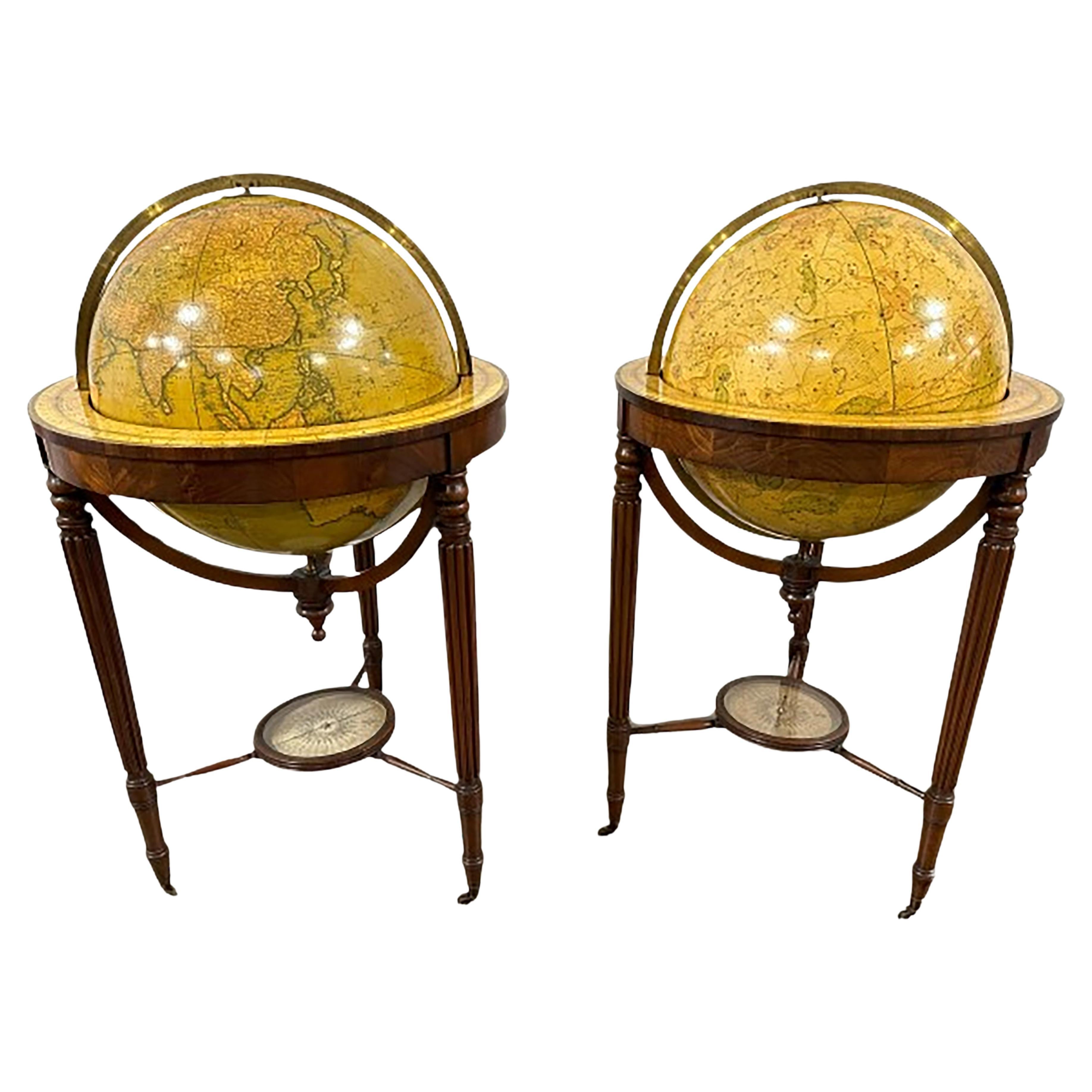
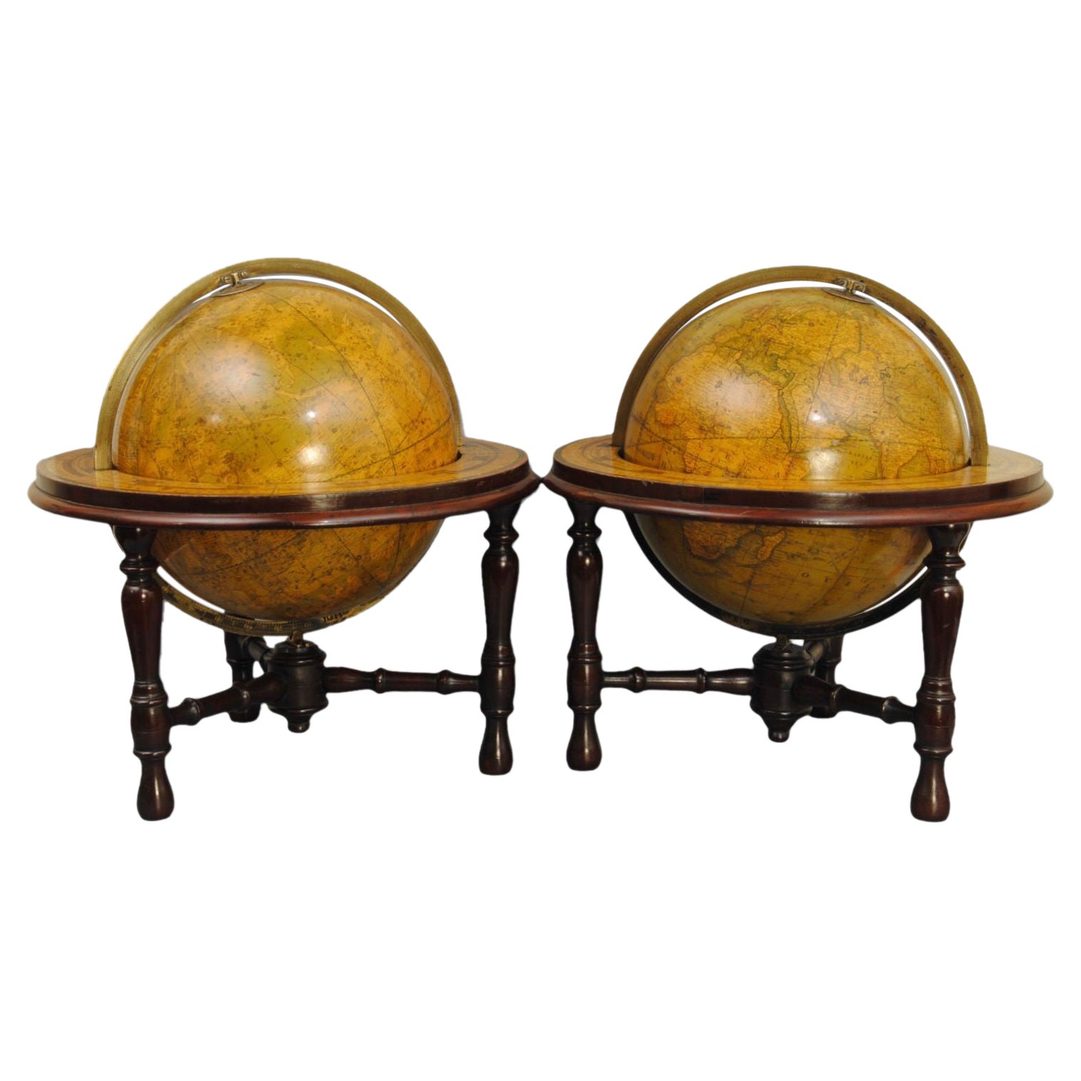
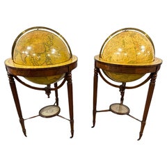
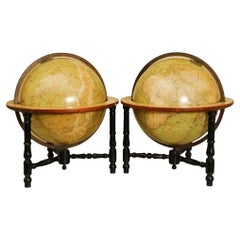
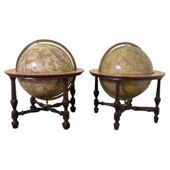
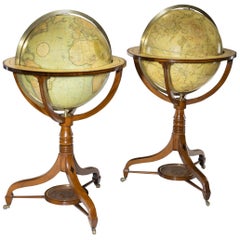
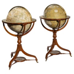
A huge pair of 21 inches Cruchley Library Globes
$135,410.21per set
$180,546.95per set25% Off
£98,509.44per set
£131,345.92per set25% Off
€112,500per set
€150,000per set25% Off
CA$184,796.08per set
CA$246,394.77per set25% Off
A$205,787.10per set
A$274,382.80per set25% Off
CHF 107,100.81per set
CHF 142,801.08per set25% Off
MX$2,537,330.12per set
MX$3,383,106.82per set25% Off
NOK 1,364,010.78per set
NOK 1,818,681.03per set25% Off
SEK 1,282,037.90per set
SEK 1,709,383.87per set25% Off
DKK 856,177.38per set
DKK 1,141,569.85per set25% Off
Shipping
Retrieving quote...The 1stDibs Promise:
Authenticity Guarantee,
Money-Back Guarantee,
24-Hour Cancellation
About the Item
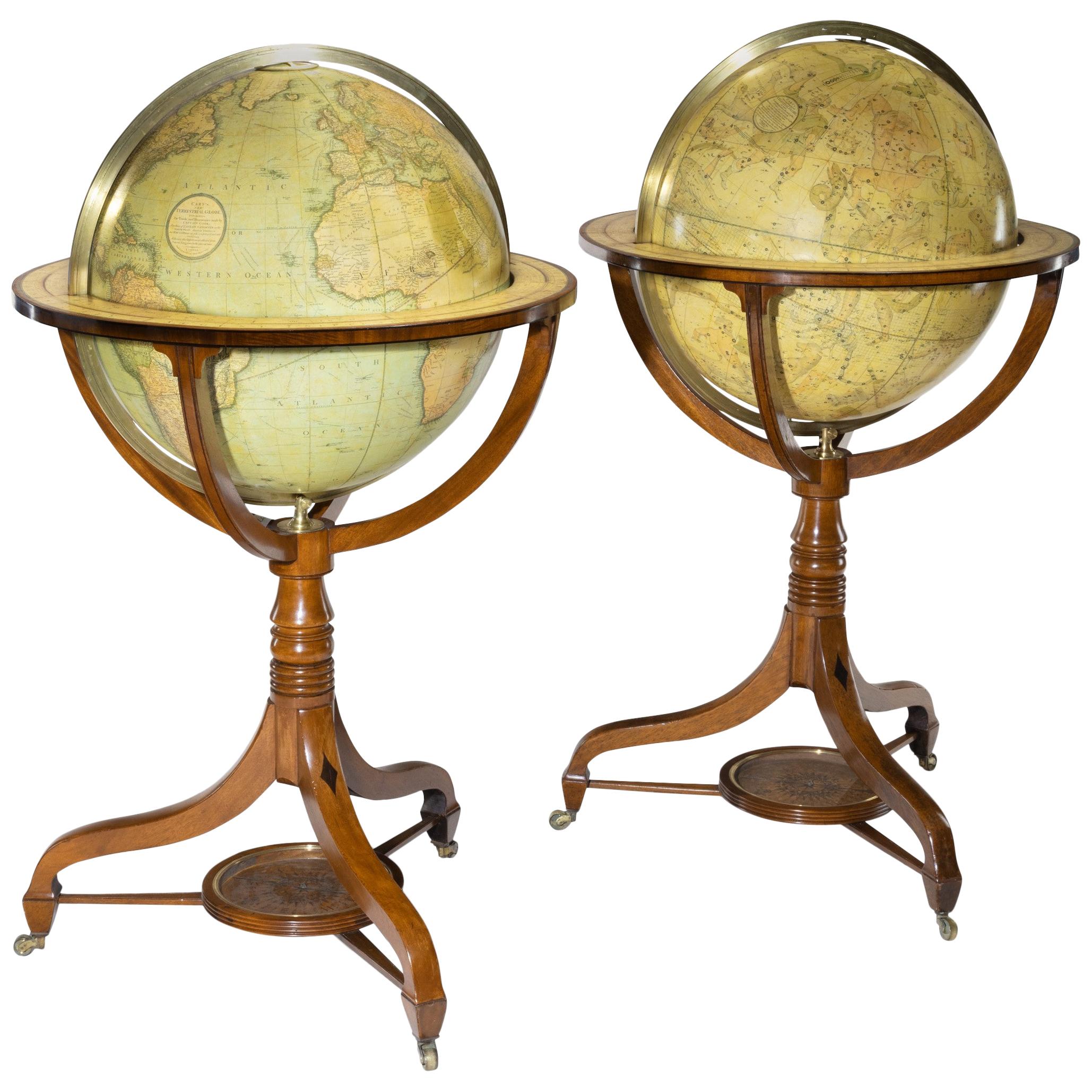
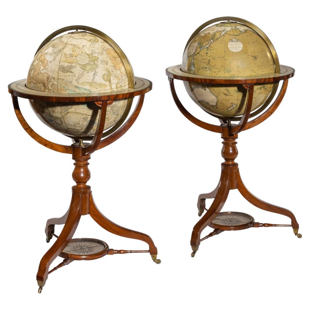
G.F. Cruchley (UK, 1796-1880)
London ca 1850
A magnificent pair of terrestrial and celestial globes. Equatorial table engraved with the signs of the zodiac and resting on 3 mahogany molded feet held by a compass at the spacer. With graduated brass meridian circles and time clocks. The terrestrial globe is inscribed in a cartouche: Cruchley's new terrestrial globe from the most recent and best authorities. Exhibiting the discoveries in equatorial Africa, north pole. And the new settlements and divisions in Australia, New Zealand, Californa, Texas, &c. London. Sold by Gould and Porter opticians 181 strand WC. The celestial globe is inscribed in a cartouche: Cruchleys new celestial globe on which is accurately laid down the whole of the stars and nebule contained in the astronomical catalogue of the Reverend Mr. Wollaston F.R.S. Also from the authorities Flamstead, De La Caille, Hevellus, Bradley, Herschel, Maskelyne, &c. Ands the limits of each constellation determined by a boundary line. London, published by G.F. Cruchley, map-seller & globe maker, 81 Fleet street.
Signed: CRUCHLEY in London England, circa 1850 H. 125 cm Diam. 53 cm (21 inches) Diam. 25 cm compasses The two spheres are in a perfect state of freshness and are perfectly legible.
The condition of both the globes is very good. There have been some professional repairs to some damaged gores. The Terrestrial globe in good conserved and legible condition, it has areas of rubbing, retouching, and slight discoloration. The Celestial globe is also in good conserved and legible condition with areas of rubbing, retouching and slight discoloration. The gores themselves have been cleaned and revarnished. The splendid mahogany legs and moulded feet are in first class condition. Each globe consists of 12 hand coloured copper engraved gores over a paper-maché hollow core, made up of two hemispheres joined at the equator and covered with a layer of plaster. There are paper horizon rings, made up of a series of concentric circles, displaying the months of the year, the signs of the zodiac and wind directions.
THE TERRESTRIAL GLOBE.
The globe provides much detailed information, and was accurate up to the date of production, which in this case is the mid-19th century. It shows the latest discoveries and developments that had taken place. It displays names and territories that were once familiar to the people of the age, 150 years into the future! In Asia for example, there are places like ‘Little Bucharia’, ‘Little and Greater Tartary’, ‘Russia in Asia.’ Undoubtedly, the continent that has changed more than any other is Africa. So many African countries that we know and recognise now, had different, perhaps more ‘Colonial’ names more than a century and a half ago. There was ‘Nubia’ (Sudan/Egypt), ‘Abbyssinia’ (Ethiopia), ‘Cape Colony’ (South Africa), ‘Dahomey’ (Benin) but to name a few. Australia was a little over 50 years away from its union via ‘Federation’ in 1901. This brought about the Commonwealth of Australia. However, in 1850 they were six separate British selfserving colonies, ruled directly from England.
In North America, both Los Angeles and San Francisco are incorporated as cities into California - as it becomes the 31st U.S. state. Much of mid-western and western USA were known as ‘The Western Territory’ & ‘The Missouri Territory’, Florida was still refered to as ‘East & West Florida’. Canada was split into ‘Canada East’ & ‘Canada West.’ Canada East was primarily (for historical reasons) French-speaking, and Canada West primarily Englishspeaking. Much of Western Canada remained unexplored and undeveloped. In Europe, there was still the ‘Russian Empire’, the ‘Ottoman Empire’, the ‘AustroHungarian Empire’, and the German ‘Prussian Empire.’
THE CELESTIAL GLOBE.
The Celestial Globe displays the stars, the constellations, clusters and nebulae in a beautiful and well thought out manner. Mythical figures and signs of the zodiac are seen. The equinoctial and solistitial colures are graduated in degrees. Although the colour is somewhat muted, it takes nothing away from the overall beauty and the undoubted aesthetic qualities of the globe.
Historically, globes are among the most ancient scientific instruments known to man. They can be dated back over two millennia, and are still manufactured to this day. The earliest tradition of globe making is mainly concerned with celestial globes – man has always been fascinated and drawn to the heavens above. Celestial globes have always enjoyed a precedent of terrestrial globes. In fact, doubts about the feasibility of a terrestrial globe were firmly expressed by the Greek geographer Strabo; who wrote that such a globe would only make sense if its diameter were approximately 10 foot, presumably because only then could it furnish sufficient geographical detail! The great second century Egyptian mathematician, astronomer, astrologer, and geographer, Claudius Ptolemy also considered the large size of a globe to be somewhat of an obstacle, and noted a further shortcoming of a terrestrial globe – that one could not view the whole world on it a single glance. As a result, terrestrial globes were not as popular until much later. The real beauty of globes is that they can be considered to be “all things to all men”; to some they are useful and practical educational tools, (3D maps perhaps); to some others as beautiful and useful scientific instruments; and to more, they may be seen purely as decorative, beautiful pieces of furniture; to be envied and enjoyed, but more importantly, and above all, to be admired by all.
Georges Frederick CRUCHLEY (active 1797-1880)
George Frederick Cruchley was a London based book and map seller, active in the mid-19th century. He worked with the Cary firm, and in 1850 and he appended his name to the address 81 Fleet Street in London. This address is covered over the globe, as is often the case with the reseller's corporate name. Cruchley began his cartographic career as an apprentice in the venerable film Aaron Arrowsmith. Many of Cruchley's early maps have the words "From Arrowsmith" on the imprint. In 1844 Cruchley acquired the massive stock of the important early 19th century firm, John Cary. Cruchley published his own maps as well as reissues of Cary's stock until the 1870s. He is best known for his detailed plans of London, which in recent years have become increasingly rare and desirable. Cruchley was based in London at 38 Ludgate Street until 1834 when he moved his office to 81 Fleet Street. Shortly before his death in 1880, Cruchley auctioned off (Hodgson's Auctions, January 16, 1877) all of his stock. Many of his map plates were thus acquired by "Gall and Inglis" who continued the Cruchley tradition until the early 20th century. Cruchley's son, also George Frederick (1837-1882), continued to work as a book and map seller until his death.
- Creator:G.F. Cruchley (Maker)
- Dimensions:Height: 50 in (127 cm)Diameter: 21 in (53.34 cm)
- Sold As:Set of 2
- Style:Victorian (Of the Period)
- Materials and Techniques:
- Place of Origin:
- Period:
- Date of Manufacture:1850
- Condition:Contemporary and in excellent condition except for one scratch on the horizonring (see picture).
- Seller Location:ZWIJNDRECHT, NL
- Reference Number:Seller: Jacob B. de Roo, The Netherlands, Antiquarian since 20041stDibs: LU9419237364012
About the Seller
No Reviews Yet
Vetted Professional Seller
Every seller passes strict standards for authenticity and reliability
Established in 2004
1stDibs seller since 2023
- ShippingRetrieving quote...Shipping from: ZWIJNDRECHT, Netherlands
- Return Policy
Authenticity Guarantee
In the unlikely event there’s an issue with an item’s authenticity, contact us within 1 year for a full refund. DetailsMoney-Back Guarantee
If your item is not as described, is damaged in transit, or does not arrive, contact us within 7 days for a full refund. Details24-Hour Cancellation
You have a 24-hour grace period in which to reconsider your purchase, with no questions asked.Vetted Professional Sellers
Our world-class sellers must adhere to strict standards for service and quality, maintaining the integrity of our listings.Price-Match Guarantee
If you find that a seller listed the same item for a lower price elsewhere, we’ll match it.Trusted Global Delivery
Our best-in-class carrier network provides specialized shipping options worldwide, including custom delivery.More From This Seller
View AllA decorative pair of rare table globes in a fine condition.
By Johann Gabriel Doppelmayr
Located in ZWIJNDRECHT, NL
These pair of globes, dated 1730, are original and in fine condition.
Title:
Globus terrestris novus Loca Terrae insigniora sec. praestant Astron. et Geogr. observationes sistens op...
Category
Antique Early 18th Century German Baroque Globes
Materials
Other
A pair of extremely rare Valk table globes
By Gerard and Leonard Valk
Located in ZWIJNDRECHT, NL
Title on the globes:
VALK, Gerard and Leonard. [Terrestrial globe:] Cosmotheore, caelesti nostro globo, par, et plane novus, hic terrestris ut existeret, certo scias, errore veterum ...
Category
Antique 18th Century Dutch Dutch Colonial Globes
Materials
Other
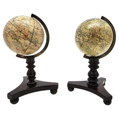
Lovely pair of English miniature globes on carved wooden stands
By Newton and Son
Located in ZWIJNDRECHT, NL
“NEWTON’S NEW & IMPROVED TERRESTRIAL and CELESTIAL GLOBES".
PUBLISHED BY NEWTON & SON,
66 CHANCERY LANE, LONDON.”
No date but ca. 1820-1830.
Diameter globes 2.75 inches / Total heig...
Category
Antique 1820s British Victorian Globes
Materials
Wood
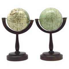
A fine pair of miniature globes on stands
By Karl Muller
Located in ZWIJNDRECHT, NL
A rare pair of miniature terrestrial and celestial globes.
by K. Müller, 1822
Karlsruhe, Germany
Diameter globes: 7 cm. Total high: 14,5 cm.
Each with 12 hand-coloured engraved p...
Category
Antique Early 19th Century German International Style Globes
Materials
Hardwood, Paper
A beautiful Celestial Table Globe produced by Gerard & Leonard Valk
By Gerard and Leonard Valk
Located in ZWIJNDRECHT, NL
A magnificent and very rare early 18th century celestial table globe produced by Gerard and Leonard Valk. Established at the end of the previous ...
Category
Antique Early 18th Century Dutch Dutch Colonial Globes
Materials
Other
$192,583 Sale Price
20% Off
Free Shipping
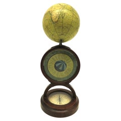
An English POCKET GLOBE with dial for time zones
By Newton and Son
Located in ZWIJNDRECHT, NL
NEWTON & SON (fl.1840-61)
AN ENGLISH POCKET GLOBE WITH A DIAL FOR TIME ZONES, CIRCA 1835
A previously unrecorded stand for an early-19th-century English globe.
A 3-inch (7.6cm.) di...
Category
Antique 1830s British Other Globes
Materials
Mahogany
You May Also Like
Pair of 19th Century Cruchley Terrestrial Library Globes with Compasses
By G.F. Cruchley
Located in Dallas, TX
A handsome set of collectable Mid 19th Century library Globes with compasses on castors. Created by George Fredrick Cruchley circa 1850. Compasses sit directly below the globes. Very...
Category
Antique Mid-19th Century British Globes
Materials
Glass, Wood
Pair of 19th Century Table Globes by Crunchley
Located in Lincolnshire, GB
A pair of 12" table globes by the well known map maker Crunchley, London. In the original and very smart mahogany stands. Circa 1865.
Category
Antique 19th Century English Globes
Materials
Mahogany, Paper

$15,422 / set
Rare and Large Pair of Malby Globes in Fine Original Condition
Located in Lincolnshire, GB
The largest pair of 19th century table globes we have had , at 18' diameter for the globes this pair has ebonised stands. Good original lacquer and colour to the papers. Good makers ...
Category
Antique Mid-19th Century Scientific Instruments
Materials
Fruitwood
A Pair of English 9-Inch Terrestrial and Celestial Table Globes by Wm. Bardin
Located in San Francisco, CA
A fine pair of English 9" terrestrial and celestial globes, each with engraved meridian rings, resting in mahogany stands with turned stretchers, both signed by the maker Wm. Bardin ...
Category
Antique Late 18th Century English George III Globes
Materials
Mahogany, Paper
Pair of George III Globes by J&W Cary Dated 1815 and 1800
By Cary’s
Located in Lymington, Hampshire
A pair of George III 21 inch globes by J&W Cary, dated 1815 and 1800, set in mahogany stands with turned urn-shaped supports raised on three outsplayed legs with original castors fee...
Category
Antique Early 1800s English Globes
Materials
Mahogany
Pair of 18 Inch Floor Standing Globes by C Smith & Son
Located in Lymington, Hampshire
A pair of 18 inch floor standing globes by C Smith & Son, each set into a mahogany stand with a turned baluster support and three legs centred on a compass, on...
Category
Antique 1840s English Globes
Materials
Mahogany
More Ways To Browse
H G Wells
Antique Egyptian Ring
Antique Class Ring
Mid Century Mens Ring
19th Century Russian Ring
French Mens Rings
Mens Rings Aesthetic
Antique Victorian Cape
Antique Paper Mache Molds
G Gould
Western Union Sign
Victorian Copper Molds
G Plan Ottoman
Paper Mache Plate
John Hodgson
Polychrome Dutch Tiles
Porcelain Hunting Dogs
Porcelain Hydrangea