Items Similar to Antique Map of the Coast of Acapulco by Anson, c.1740


Want more images or videos?
Request additional images or videos from the seller
1 of 5
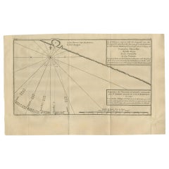
Antique Map of the Coast of Acapulco by Anson, c.1740
About the Item
Antique map titled 'Disposition des Vaisseaux de l'Escadre commandée par Mr. Anson croisant vis à vis d'Acapulco en 1742'. This map depicts the coast of Acapulco in Mexico with a decorative cartouche and windrose. Acapulco and its port were important to the Mission of Commodore George Anson, who captured a Spanish treasure galleon traveling between Acapulco and Manila. Source unknown, to be determined.
Artists and Engravers: George Anson, 1st Baron Anson PC, FRS, RN (1697 -1762) was a British admiral and a wealthy aristocrat, noted for his circumnavigation of the globe and his role overseeing the Royal Navy during the Seven Years' War.
We sell original antique maps to collectors, historians, educators and interior decorators all over the world. Our collection includes a wide range of authentic antique maps from the 16th to the 20th centuries. Buying and collecting antique maps is a tradition that goes back hundreds of years. Antique maps have proved a richly rewarding investment over the past decade, thanks to a growing appreciation of their unique historical appeal. Today the decorative qualities of antique maps are widely recognized by interior designers who appreciate their beauty and design flexibility. Depending on the individual map, presentation, and context, a rare or antique map can be modern, traditional, abstract, figurative, serious or whimsical. We offer a wide range of authentic antique maps for any budget.
- Dimensions:Height: 9.85 in (25 cm)Width: 15.75 in (40 cm)Depth: 0 in (0.01 mm)
- Materials and Techniques:Paper,Engraved
- Period:
- Date of Manufacture:circa 1740
- Condition:Condition: Good, minor defects from handling. Please study image carefully.
- Seller Location:Langweer, NL
- Reference Number:
About the Seller
5.0
Platinum Seller
These expertly vetted sellers are 1stDibs' most experienced sellers and are rated highest by our customers.
Established in 2009
1stDibs seller since 2017
1,929 sales on 1stDibs
Typical response time: <1 hour
- ShippingRetrieving quote...Ships From: Langweer, Netherlands
- Return PolicyA return for this item may be initiated within 14 days of delivery.
More From This SellerView All
- Antique Map of the Coast of Acapulco by Anson, 1749Located in Langweer, NLAntique map titled 'Disposition des Vaisseaux de l'Escadre commandée par Mr. Anson croisant vis à vis d'Acapulco en 1742'. This map depicts the coast of Acapulco in Mexico with a decorative cartouche and windrose. Acapulco and its port were important to the mission of Commodore George Anson, who captured a Spanish treasure...Category
Antique Mid-18th Century Prints
MaterialsPaper
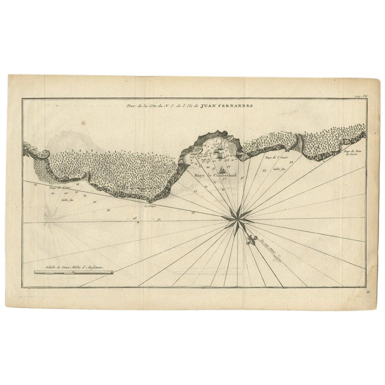
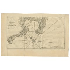
- Antique Map of Juan Fernandez Island by Anson, c.1740Located in Langweer, NLAntique map titled 'Plan de la Côte du N.E. de l 'Ile de Juan Fernandes'. Map of the northeast coast of the island of Juan Fernandez with Cumberland Bay, South America. In 1740 Ans...Category
Antique 18th Century Maps
MaterialsPaper
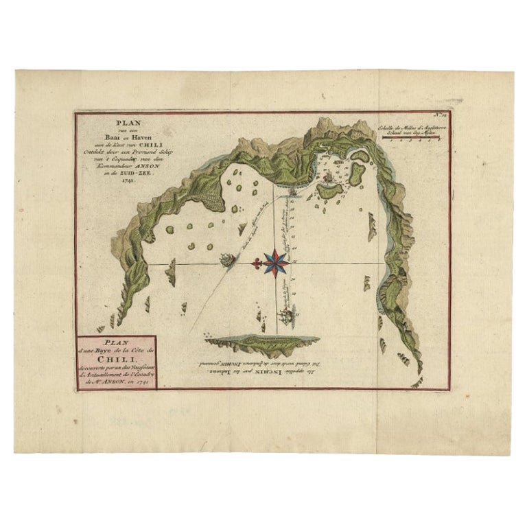
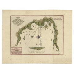
- Antique Map of a Bay on the Coast of Chile by Anson, 1749Located in Langweer, NLAntique map titled 'Plan van een Baai en Haven aan de Kust van Chili (..) - Plan d'une Baye de la Côte du Chili (..)'. Original antique map of a bay on the coast of Chile discovered ...Category
Antique 18th Century Maps
MaterialsPaper
- Antique Map of the Philippines by Anson '1749'Located in Langweer, NLAntique map titled 'Carte du Canal des Iles Philippines - Kaart van het Kanaal in de Filippynsche Eilanden'. Large detailed chart of the islands of the Philippines. One of the most detailed charts of the Philippines of the era. Shows Islands, bays, reefs, soundings tracks of the Manila Galleon route, etc. Includes a large compass...Category
Antique Mid-18th Century Maps
MaterialsPaper
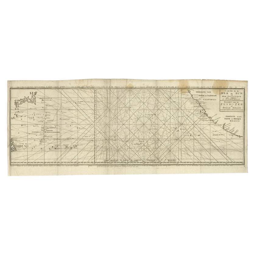
- Antique Map of the Pacific Ocean by Anson, 1765Located in Langweer, NLAntique map titled 'Carte de la Mer du Sud ou Mer Pacifique - Kaart van de Zuyd-Zee of stille oceaan (..)'. Nautical chart of the Pacific Ocean depicting the trade routes used by Spanish Galleons from Acapulco in Mexico to Manila in the Philippines. In particular this chart depicts the voyages of the Spanish Nostra Seigniora de Cabadonga and the British Navy Commodore George Anson. Anson succeed in capturing the Spanish treasure...Category
Antique 18th Century Maps
MaterialsPaper
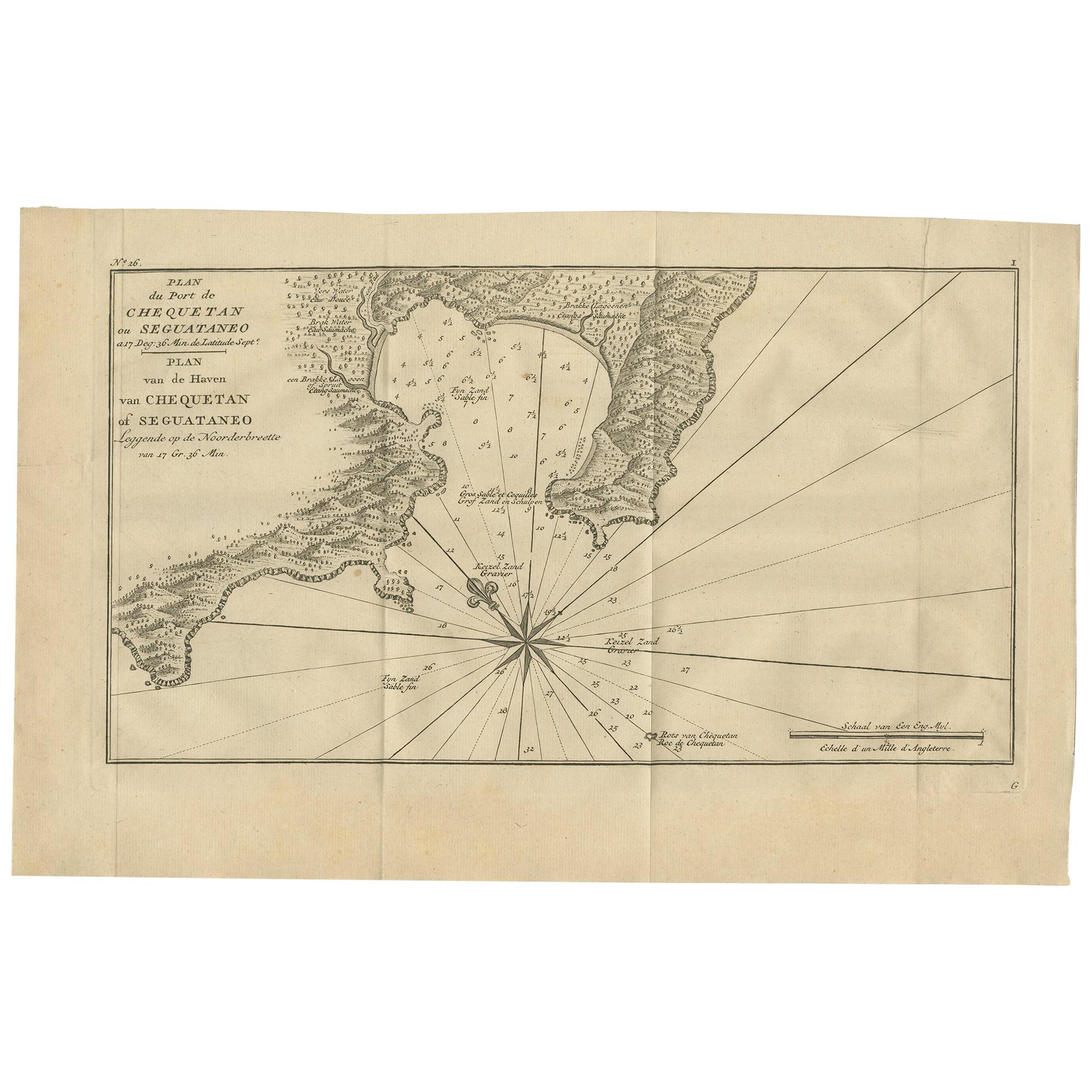
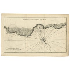
- Antique Map of the Port of Zihuatanejo by Anson '1749'Located in Langweer, NLAntique map titled 'Plan du Port de Chequetan ou Seguataneo - Plan van de Haven van Chequetan of Seguataneo'. Map of the Mexican port of Zihuatanejo. This area was originally named C...Category
Antique Mid-18th Century Maps
MaterialsPaper


You May Also Like
- 1861 Topographical Map of the District of Columbia, by Boschke, Antique MapLocated in Colorado Springs, COPresented is an original map of Albert Boschke's extremely sought-after "Topographical Map of the District of Columbia Surveyed in the Years 1856 ...Category
Antique 1860s American Historical Memorabilia
MaterialsPaper
- Northwest Coast and Isle of Man MapLocated in Cheshire, GBGreenville Collins Northwest Coast and Isle of Man. hand coloured chart, encased in an ebonised frame. Dimensions Height 26.5 Inches Width 30 Inches Depth 1 InchesCategory
Early 20th Century British Maps
MaterialsPaper
- Original Antique Decorative Map of South America-West Coast, Fullarton, C.1870Located in St Annes, LancashireGreat map of Chili, Peru and part of Bolivia Wonderful figural border From the celebrated Royal Illustrated Atlas Lithograph. Original color. Published by Fullarton, Edi...Category
Antique 1870s Scottish Maps
MaterialsPaper
- 18th Century Emanuel Bowen Map of County of York, c.1740By Emanuel BowenLocated in Royal Tunbridge Wells, KentAntique 18th century British rare and original Emanuel Bowen (1694-1767) map of the County of York divided into its Ridings and subdivided into wapontakes, mounted in solid wood fram...Category
Antique Early 18th Century British Maps
MaterialsPaper
- Original Antique Map of The World by Thomas Clerk, 1817Located in St Annes, LancashireGreat map of The Eastern and Western Hemispheres On 2 sheets Copper-plate engraving Drawn and engraved by Thomas Clerk, Edinburgh. Published by Mackenzie And Dent, 1817 ...Category
Antique 1810s English Maps
MaterialsPaper
- 1907 Map of Colorado, Antique Topographical Map, by Louis NellLocated in Colorado Springs, COThis highly detailed pocket map is a topographical map of the state of Colorado by Louis Nell from 1907. The map "has been complied from all availabl...Category
Antique Early 1900s American Maps
MaterialsPaper


Recently Viewed
View AllMore Ways To Browse
Antique Globes Of The World
Mexican 18th Century
Mexican 18th Century Furniture
Mexico Map
Mexican Map
Vis A Vis
Vis A
Hundred Treasures
British Royal Navy
The Galleon
Antique Map Britain
Antique Britain Map
Spain Antique Map
Antique Maps Spain
Antique Spain Map
Antique Map Spain
Antique Maps Of Spain
Antique Map Of Spain