Items Similar to Antique Map of the Port of Zihuatanejo by Anson '1749'


Want more images or videos?
Request additional images or videos from the seller
1 of 5
Antique Map of the Port of Zihuatanejo by Anson '1749'
About the Item
Antique map titled 'Plan du Port de Chequetan ou Seguataneo - Plan van de Haven van Chequetan of Seguataneo'. Map of the Mexican port of Zihuatanejo. This area was originally named Cihuatlán in Aztec, which means 'Place of Women,' referring to the matriarchal society that dominated the region in pre-Columbian times. This map originates from 'Reize rondsom de Werreld (..)' by George Anson, published 1749.
- Dimensions:Height: 10.63 in (27 cm)Width: 16.74 in (42.5 cm)Depth: 0.02 in (0.5 mm)
- Materials and Techniques:
- Period:
- Date of Manufacture:1749
- Condition:Age-related toning, original folding lines. Shows some wear and staining, blank verso. Please study images carefully.
- Seller Location:Langweer, NL
- Reference Number:
About the Seller
5.0
Platinum Seller
These expertly vetted sellers are 1stDibs' most experienced sellers and are rated highest by our customers.
Established in 2009
1stDibs seller since 2017
1,929 sales on 1stDibs
Typical response time: <1 hour
- ShippingRetrieving quote...Ships From: Langweer, Netherlands
- Return PolicyA return for this item may be initiated within 14 days of delivery.
More From This SellerView All
- Antique Map of the Philippines by Anson '1749'Located in Langweer, NLAntique map titled 'Carte du Canal des Iles Philippines - Kaart van het Kanaal in de Filippynsche Eilanden'. Large detailed chart of the islands of the Philippines. One of the most detailed charts of the Philippines of the era. Shows Islands, bays, reefs, soundings tracks of the Manila Galleon route, etc. Includes a large compass...Category
Antique Mid-18th Century Maps
MaterialsPaper
- Antique Map of Coiba Island by Anson '1749'Located in Langweer, NLAntique map titled 'Plan van de Oost-Zyde van het Eiland Quibo'. Original antique map of the eastside of Coiba Island (Quibo), Panama, showing the shoreline around Port de Dames indi...Category
Antique Mid-18th Century Maps
MaterialsPaper
- Antique Map of South America by G. Anson, 1749Located in Langweer, NLAntique map titled 'Kaart van het Zuidelykste Gedeelte van Zuider Amerika (..) - Carte de la Partie Meridionale de l'Amerique Meridionale (..)'. Detailed chart tracking the route of Capt. George Anson's ship The Centurion in 1745. The chart shows the tracks of Anson's ships around South America & Cape Horn to the Juan Fernandes Islands, with notes on currents and positions. This map originates from 'Reize rondsom de Werreld (..)' by George Anson, published 1749. In 1740 Capt. George Anson (1697-1762) of the Royal Navy, was given command of a squadron of ships. As England was at war with France and Spain, Anson's task was to intercept and capture a Spanish treasure...Category
Antique Mid-18th Century Dutch Maps
MaterialsPaper
- Antique Map of Juan Fernandez Island by Anson '1749'Located in Langweer, NLAntique map titled 'l'Ile de Juan Fernandes dans la Mer du Sud (..) - Het Eiland Juan Fernandes in de Zuid Zee (..)'. This map depicts Juan Fernandez Island in the Southern Sea. This...Category
Antique Mid-18th Century Maps
MaterialsPaper
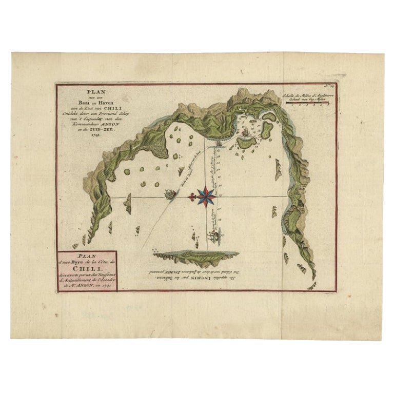
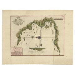
- Antique Map of a Bay on the Coast of Chile by Anson, 1749Located in Langweer, NLAntique map titled 'Plan van een Baai en Haven aan de Kust van Chili (..) - Plan d'une Baye de la Côte du Chili (..)'. Original antique map of a bay on the coast of Chile discovered ...Category
Antique 18th Century Maps
MaterialsPaper
- Antique Print of Zihuatanejo and the Harbour of Acapulco by Anson '1749'Located in Langweer, NLAntique print titled 'Vue de l'entree de Chequetan ou Seguataneo, restant au N.E. a la distance de 5 milles.' 'Vue de l'entree du port d'Acapulco.' View of Zihuatanejo and the harbou...Category
Antique Mid-18th Century Prints
MaterialsPaper


You May Also Like
- Original Antique Map of The World by Thomas Clerk, 1817Located in St Annes, LancashireGreat map of The Eastern and Western Hemispheres On 2 sheets Copper-plate engraving Drawn and engraved by Thomas Clerk, Edinburgh. Published by Mackenzie And Dent, 1817 ...Category
Antique 1810s English Maps
MaterialsPaper
- Original Antique Map of The Netherlands, Engraved by Barlow, Dated 1807Located in St Annes, LancashireGreat map of Netherlands Copper-plate engraving by Barlow Published by Brightly & Kinnersly, Bungay, Suffolk. Dated 1807 Unframed.Category
Antique Early 1800s English Maps
MaterialsPaper
- Map of the Republic of GenoaLocated in New York, NYFramed antique hand-coloured map of the Republic of Genoa including the duchies of Mantua, Modena, and Parma. Europe, late 18th century. Dimension: 25...Category
Antique Late 18th Century European Maps
- Antique Map of Italy by Andriveau-Goujon, 1843By Andriveau-GoujonLocated in New York, NYAntique Map of Italy by Andriveau-Goujon, 1843. Map of Italy in two parts by Andriveau-Goujon for the Library of Prince Carini at Palazzo Carini i...Category
Antique 1840s French Maps
MaterialsLinen, Paper
- Antique Map of Principality of MonacoBy Antonio Vallardi EditoreLocated in Alessandria, PiemonteST/619 - "Old Geographical Atlas of Italy - Topographic map of ex-Principality of Monaco" - ediz Vallardi - Milano - A somewhat special edition ---Category
Antique Late 19th Century Italian Other Prints
MaterialsPaper
- Original Antique Map of Russia By Arrowsmith. 1820Located in St Annes, LancashireGreat map of Russia Drawn under the direction of Arrowsmith Copper-plate engraving Published by Longman, Hurst, Rees, Orme and Brown, 1820 Unframed.Category
Antique 1820s English Maps
MaterialsPaper


Recently Viewed
View AllMore Ways To Browse
George Map
Mexican 18th Century
Mid Haven Furniture
Mexican 18th Century Furniture
Mexican Map
Mexico Map
Maps Of Mexico
Map Of Mexico
Antique Map Mexico
Antique Mexico Map
Antique Map Of Mexico
Antique Maps Of Mexico
Mexico Antique Map
Antique Maps Mexico
Columbian Antique
18th Century Antique Mexican
Antique Aztec
Antique Mexican Maps