Items Similar to 1902 Murcia: A Cartographic Snapshot of Spain's Southeastern Province


Want more images or videos?
Request additional images or videos from the seller
1 of 6
1902 Murcia: A Cartographic Snapshot of Spain's Southeastern Province
$325.90
$407.3720% Off
£242.61
£303.2620% Off
€272
€34020% Off
CA$446.39
CA$557.9920% Off
A$496.49
A$620.6120% Off
CHF 259.25
CHF 324.0620% Off
MX$6,041.74
MX$7,552.1720% Off
NOK 3,311.03
NOK 4,138.7920% Off
SEK 3,105.16
SEK 3,881.4520% Off
DKK 2,070.64
DKK 2,588.3020% Off
Shipping
Retrieving quote...The 1stDibs Promise:
Authenticity Guarantee,
Money-Back Guarantee,
24-Hour Cancellation
About the Item
The map represents the province of Murcia, Spain, as it was in 1902. Here's an overview of its characteristics:
- **Geography**: It displays the varied terrain of Murcia, from the coastal plains to the internal mountain ranges.
- **Waterways**: Blue lines likely indicate rivers, including the Segura River, which is the main waterway traversing the province.
- **Roads and Railways**: Red lines denote major roads and rail networks, emphasizing the connections within Murcia and to neighboring provinces.
- **Urban and Rural Areas**: Different symbols and labels likely represent the locations of cities, towns, and other settlements.
- **Administrative Divisions**: Dotted lines might show the boundaries between municipalities within Murcia.
- **Legend**: A legend (Signos Convencionales) lists the symbols used on the map, such as for capital cities, roads, and railways.
- **Scale**: There's a scale bar for distance reference, which helps to estimate the size and distances between different locations on the map.
- **Coat of Arms**: The coat of arms of Murcia is displayed, featuring a castle and a lion, reflecting the historical heraldry of the region.
About the province of Murcia:
Murcia is known for its rich history dating back to Moorish times, with a mix of cultural influences reflected in its architecture and traditions. The region enjoys a warm Mediterranean climate, making it an important agricultural area, especially for fruits, vegetables, and flowers. The Mar Menor, a large coastal saltwater lagoon, is a distinctive feature of the area, offering unique ecosystems and recreational activities. Murcia's cuisine is diverse, featuring a mix of land and sea produce, with rice dishes, stews, and baked goods being particularly notable. Murcia is also home to numerous festivals and celebrations, including the famous Bando de la Huerta and the Fiestas de Primavera.
- Dimensions:Height: 20.08 in (51 cm)Width: 14.77 in (37.5 cm)Depth: 0 in (0.02 mm)
- Materials and Techniques:
- Period:1900-1909
- Date of Manufacture:1902
- Condition:Good condition. Central vertical folding lines as issued. Aged paper with typically warm, yellowish-brown hue, especially around the edges. Check the images carefully.
- Seller Location:Langweer, NL
- Reference Number:Seller: BG-13642-291stDibs: LU3054338032262
About the Seller
5.0
Recognized Seller
These prestigious sellers are industry leaders and represent the highest echelon for item quality and design.
Platinum Seller
Premium sellers with a 4.7+ rating and 24-hour response times
Established in 2009
1stDibs seller since 2017
2,510 sales on 1stDibs
Typical response time: <1 hour
- ShippingRetrieving quote...Shipping from: Langweer, Netherlands
- Return Policy
Authenticity Guarantee
In the unlikely event there’s an issue with an item’s authenticity, contact us within 1 year for a full refund. DetailsMoney-Back Guarantee
If your item is not as described, is damaged in transit, or does not arrive, contact us within 7 days for a full refund. Details24-Hour Cancellation
You have a 24-hour grace period in which to reconsider your purchase, with no questions asked.Vetted Professional Sellers
Our world-class sellers must adhere to strict standards for service and quality, maintaining the integrity of our listings.Price-Match Guarantee
If you find that a seller listed the same item for a lower price elsewhere, we’ll match it.Trusted Global Delivery
Our best-in-class carrier network provides specialized shipping options worldwide, including custom delivery.More From This Seller
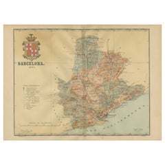
View AllBarcelona 1901: A Cartographic Portrait of Catalonia's Capital Province
Located in Langweer, NL
This orignal antique map is a historical depiction of the province of Barcelona from 1901.
It showcases the varied terrain of the province, with the Serra de Collserola ridge near the city of Barcelona and the Pyrenees to the north. The map includes the coastline along the Mediterranean Sea, indicating Barcelona's position as a coastal province. Blue lines indicate rivers, such as the Llobregat and Besòs, which are significant features in the province's geography. Dotted lines may signify the borders of the province within Catalonia.
The coat of arms of Barcelona, highlighted with gold, is prominently displayed, featuring the Cross of Saint George (Cruz de Sant Jordi), the patron saint of Catalonia, and the red and yellow bars which are a symbol of the Aragonese and Catalan heritage.
About the province of Barcelona:
The province of Barcelona is part of the autonomous community of Catalonia in northeastern Spain. It is the most economically significant region of Catalonia, playing a crucial role in the country's economy due to its port, manufacturing, and service industries. The city of Barcelona is the capital and the second most populous city in Spain, known for its rich cultural heritage, architecture by Antoni Gaudí, such as the Sagrada Família, and its influential art scene. The province enjoys a Mediterranean climate and features diverse landscapes from the beaches along the coast to the mountains in the interior. Barcelona is also known for its vibrant festivals, cuisine, fashion, and sports, particularly football, being home to FC Barcelona...
Category
Antique Early 1900s Maps
Materials
Paper
$632 Sale Price
20% Off
Free Shipping
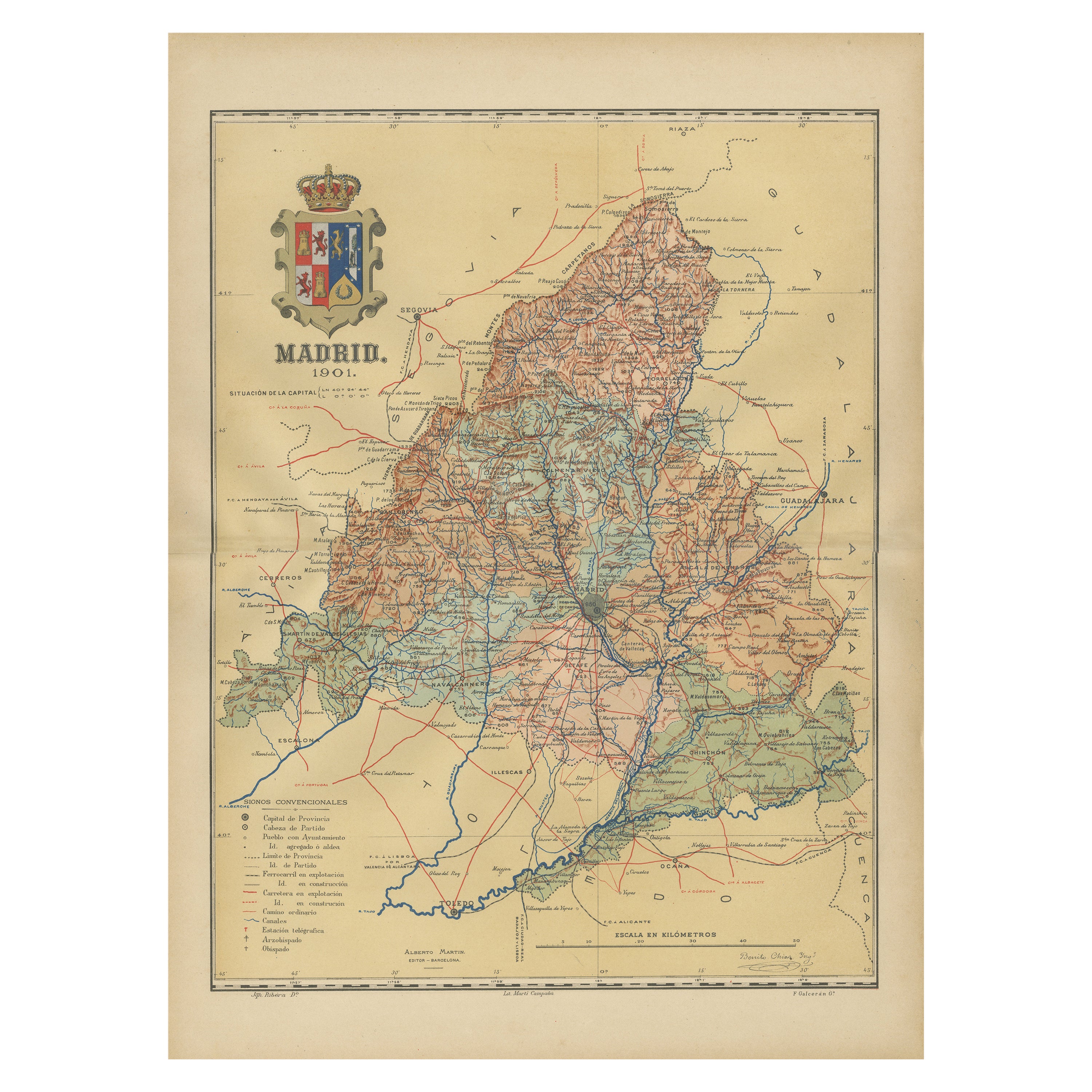
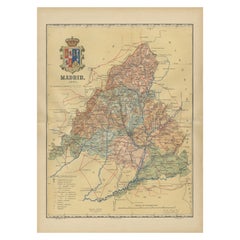
Madrid 1901: A Historical Map of Spain's Capital Province
Located in Langweer, NL
The map is of the province of Madrid, the capital region of Spain, as it appeared in 1901. Here are the key features it displays:
The map shows the central part of Spain, with the Guadarrama mountain range prominently visible, marking the natural border to the north of Madrid.
Blue lines likely indicate rivers, including the Manzanares River, which flows through Madrid, and the Jarama River, a tributary to the Tagus.
Red lines depict the roads and railways, outlining the infrastructure that connects Madrid's various towns and cities within the province and beyond.
Symbols and labels mark the locations of cities, towns, and villages, with Madrid itself likely being the focal point. Dotted lines may represent the administrative divisions within the province. The map includes a legend (Signos Convencionales) that explains the symbols used for provincial capitals, roads, railways, and other geographic features.
The coat of arms of Madrid, featuring a bear and a strawberry tree (madroño), is prominently featured, symbolizing the city's and the province's historical coat of arms.
About the province of Madrid:
Madrid is not only the capital of Spain but also the heart of the Iberian Peninsula, both geographically and politically. The city is renowned for its rich repositories of European art, including the Prado Museum's works by Goya, Velázquez, and other Spanish masters. The province of Madrid is characterized by a blend of historical and modern elements, with a rich cultural life that includes theater, opera, and flamenco, as well as gastronomy that features a mix of traditional Spanish dishes and international cuisine...
Category
Antique Early 1900s Maps
Materials
Paper
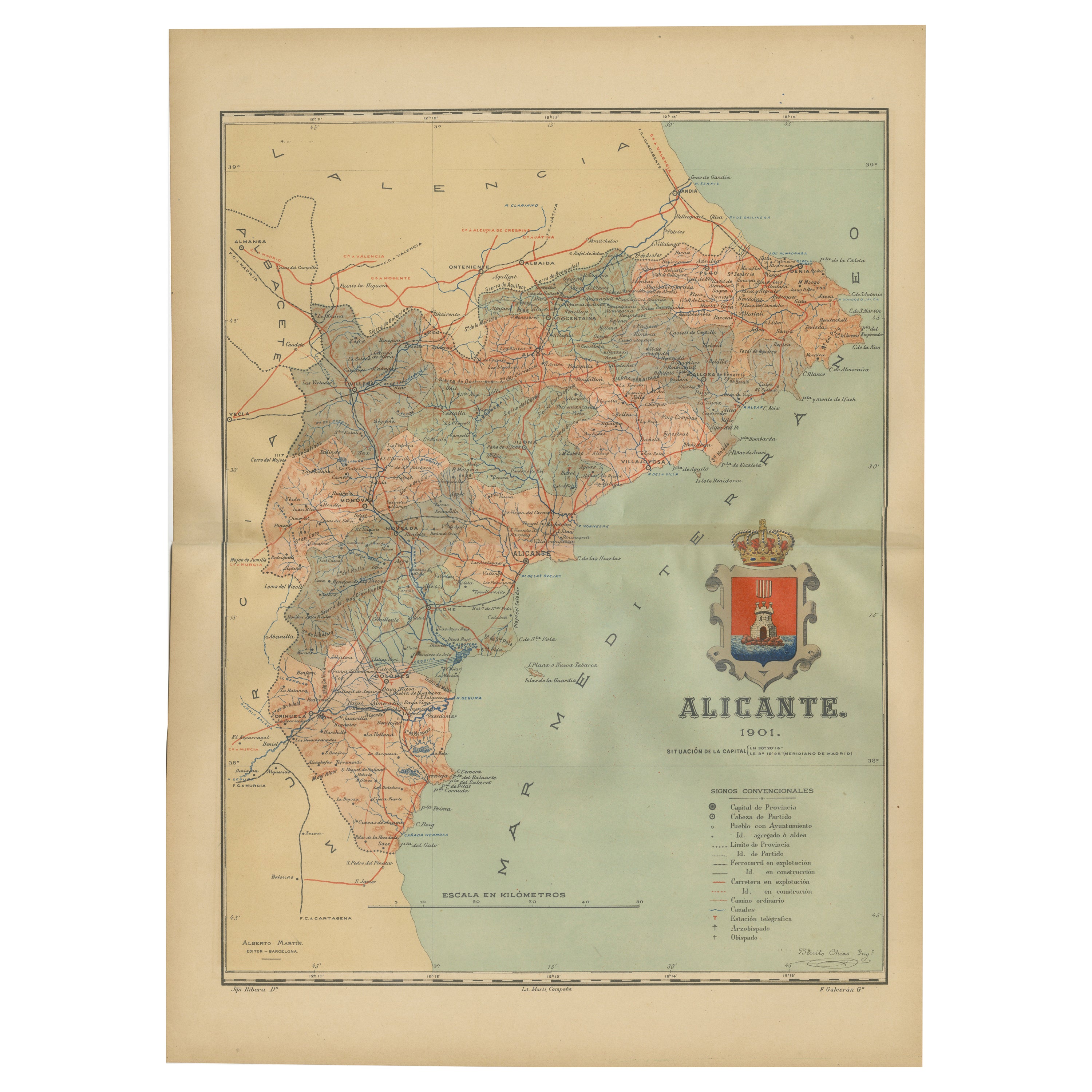
Alicante in a 1901 Antique Map: Maritime Gateway of Spain's Costa Blanca
Located in Langweer, NL
An original antique map of the province of Alicante, dated 1901. It is part of the atlas series by D. Benito Chias y Carbo, featuring cartographic elements.
Here are some characteri...
Category
Antique Early 1900s Maps
Materials
Paper

$421 Sale Price
20% Off
Free Shipping
Topographical and Infrastructure Map of the Province of Valencia, 1901
Located in Langweer, NL
A historical map of the province of Valencia, dated 1901. The map includes intricate details such as topographical features, with mountain ranges and river systems prominently marked...
Category
Antique Early 1900s Maps
Materials
Paper

$498 Sale Price
20% Off
Free Shipping
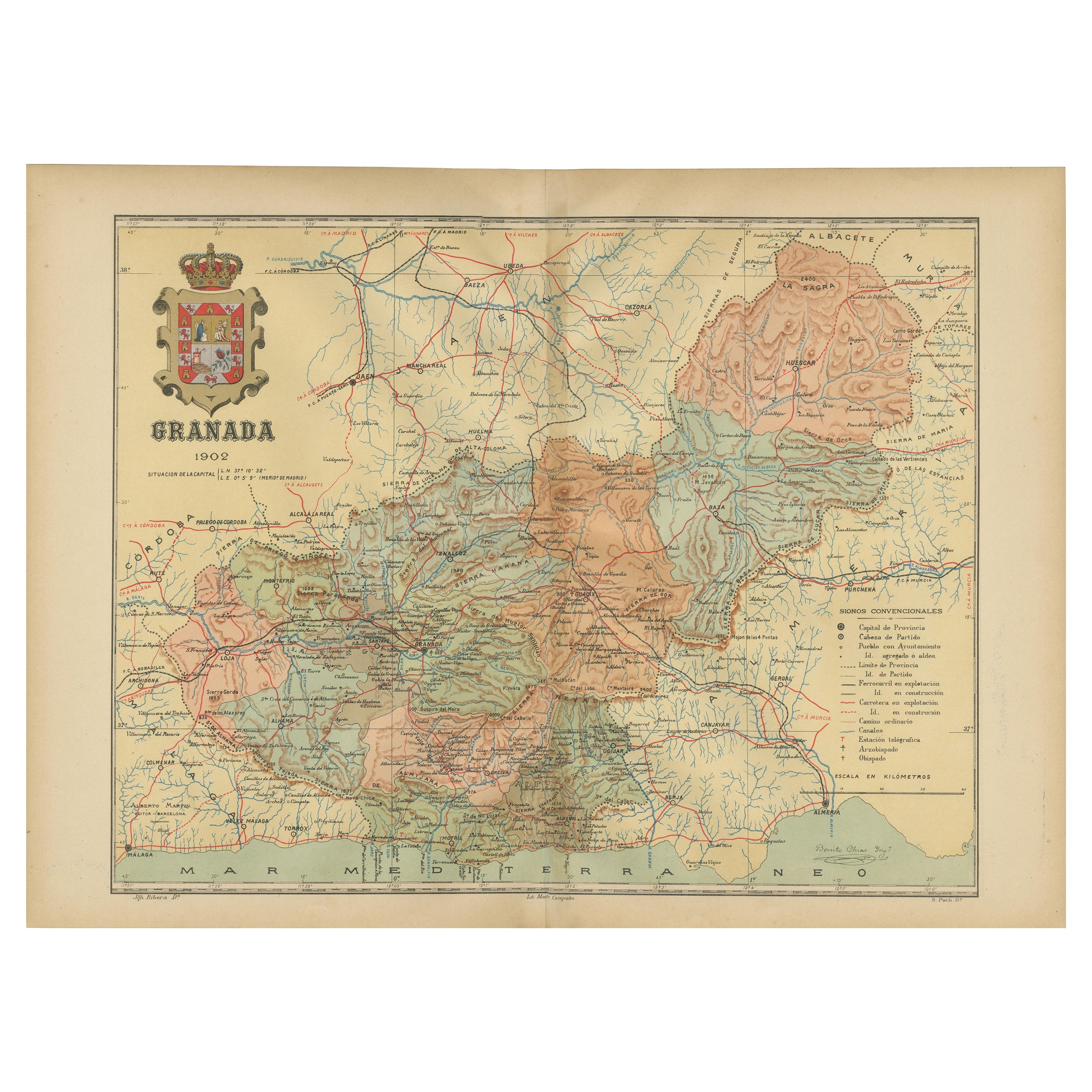
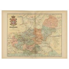
Granada 1902: A Cartographic Exploration of Andalusia's Mountainous Province
Located in Langweer, NL
This original antique map depicts the province of Granada, part of the autonomous community of Andalusia in southern Spain, as of 1902. The map features several important details:
I...
Category
Antique Early 1900s Maps
Materials
Paper
$373 Sale Price
20% Off
Free Shipping
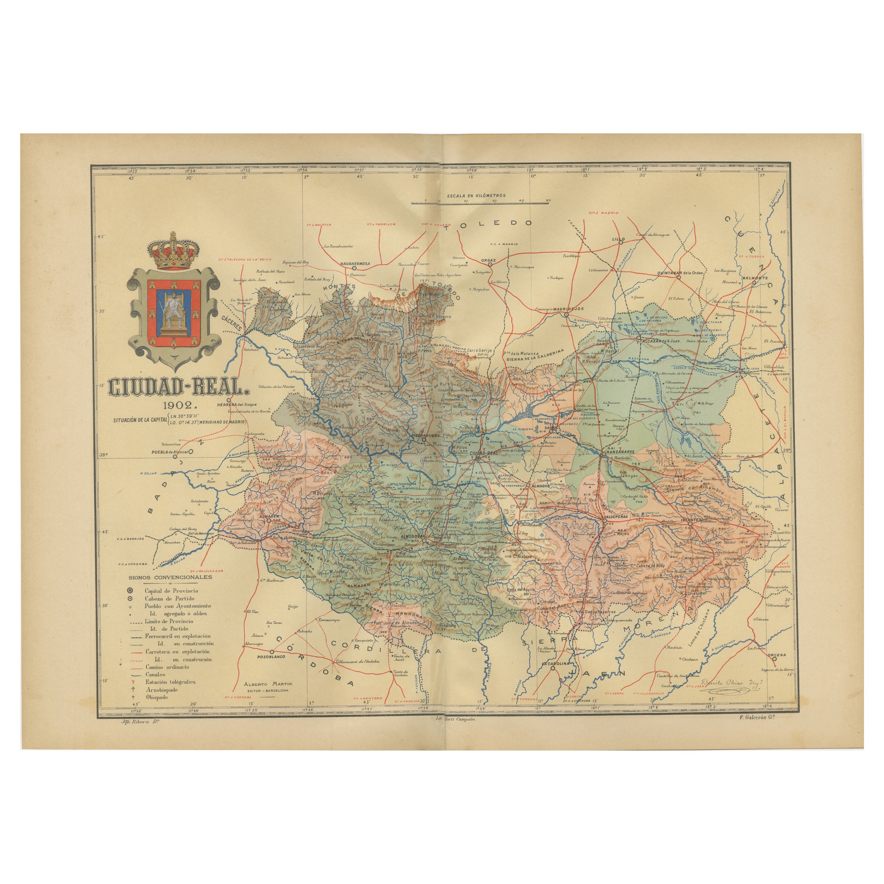
Ciudad Real 1902: A Detailed Cartographic Survey of La Mancha in Spain
Located in Langweer, NL
This original antitque map presents the province of Ciudad Real, located in the autonomous community of Castilla-La Mancha in central Spain, as of 1902. It includes several notable f...
Category
Antique Early 1900s Maps
Materials
Paper

$325 Sale Price
20% Off
Free Shipping
You May Also Like
Large Original Vintage Map of Spain, circa 1920
Located in St Annes, Lancashire
Great map of Spain
Original color.
Good condition
Published by Alexander Gross
Unframed.
Category
Vintage 1920s English Maps
Materials
Paper

Original Antique Map of Spain and Portugal, circa 1790
Located in St Annes, Lancashire
Super map of Spain and Portugal
Copper plate engraving by A. Bell
Published, circa 1790.
Unframed.
Category
Antique 1790s English Other Maps
Materials
Paper

17th Century Lithograph Framed Map of Spain
Located in Atlanta, GA
In giltwood frame, dated 1652.
Category
Antique 18th Century and Earlier Spanish Baroque Prints
Materials
Ink, Paper

18th Century Hand Colored Map of Spain and Portugal by Visscher
By Nicolaes Visscher II
Located in Alamo, CA
This is an early 18th century map of Spain and Portugal, with attractive original hand-coloring, entitled "Hispaniae et Portugalliae Regna per Nicolaum Visscher cum Privilegio Ordinu...
Category
Antique Early 18th Century Dutch Maps
Materials
Paper

Geographical Antique Map of Principality of Monaco
By Bruno Santini
Located in Alessandria, Piemonte
ST/609 - Interesting antique color map of Monaco Principality in French language : "Carte qui contient le Principauté de Piémont, le Monferrat et la comté de...
Category
Antique Late 18th Century Italian Other Maps
Materials
Paper

After Johann B. Homann (1664-1724) - 19th C, General Map of Spain and Portugal
Located in Corsham, GB
General map of Spain and Portugal divided into its current provinces by D.T. Lopez, newly drawn by F. L. G. in Nuremberg at the Heret of Homann, 1782. A double-page engraved map with...
Category
19th Century More Prints
Materials
Engraving

More Ways To Browse
Railway Map
Vegetable Dishes
Antique Vegetable Dishes
Antique Oushak
Mid Century Danish Directors Chairs
Moller 70
Argentina Travel Poster
Century Furniture Faux Bamboo
Early American Chairs
Hans Muller
Vintage Wood Table With Glass Top
19th Century Square Table
Antonio Bonet
Galle Chairs
Large Chinese Rug
1940s Vintage French Art Deco
20th Century Spanish Table
Antonio Bellini