Items Similar to 1908 John Bartholomew Miniature Map of Penang, Malacca, and Negri Sembilan

Want more images or videos?
Request additional images or videos from the seller
1 of 10
1908 John Bartholomew Miniature Map of Penang, Malacca, and Negri Sembilan
$143.90
£107.05
€120
CA$197.05
A$219.09
CHF 114.40
MX$2,666.90
NOK 1,459.67
SEK 1,367.64
DKK 913.49
Shipping
Retrieving quote...The 1stDibs Promise:
Authenticity Guarantee,
Money-Back Guarantee,
24-Hour Cancellation
About the Item
1908 John Bartholomew Map of Penang, Malacca, and Negri Sembilan from Handy Atlas of Church and Empire
Description:
This finely detailed early twentieth-century map features two inset maps on a single sheet, depicting the regions of Penang, Province Wellesley, Malacca, and Negri Sembilan in British Malaya. It was published in Handy Atlas of Church and Empire by G. H. S. Walpole and C. E. Barton, printed by Elliot Stock, London, with cartography by John Bartholomew and Company, Edinburgh.
The top half of the sheet presents a detailed map of Penang Island and Province Wellesley, which were part of the Straits Settlements under British rule. Penang had been an important British trading post since 1786, and the map shows districts including George Town, Balik Pulau, Teluk Ayer Raja, and Batu Kawan. The mainland portion, labeled as Province Wellesley, corresponds to what is now Seberang Perai and includes towns, rivers, and agricultural areas. The map highlights the strategic location of Penang along the Straits of Malacca, a crucial maritime route during the colonial era.
The bottom half of the sheet focuses on Negri Sembilan and Malacca, two regions that played significant roles in British administration and trade. Malacca, originally a Portuguese and later a Dutch colony before coming under British rule, is detailed with its ports and coastal landmarks, including Malacca Town, Ayer Panas, and lighthouse stations along the Straits of Malacca. Negri Sembilan, part of the Federated Malay States at the time, is shown with its districts, tin mines, and transportation routes. Key towns such as Seremban, Rembau, Kuala Pilah, and Tampin are labeled, reflecting the state’s economic and agricultural importance during British rule.
Both maps include scale bars measuring distances in miles, offering insights into regional geography and transportation networks. Rivers, hills, and administrative divisions are clearly marked, illustrating the layout of British-controlled territories in Malaya during the early twentieth century.
The publication of this map in a religious and imperial atlas suggests an effort to document British territories from both a geographical and ecclesiastical perspective, reinforcing the British view of its empire’s influence across Southeast Asia.
Cartographer and Source:
John Bartholomew and Company, a respected Scottish mapmaking firm, produced this map in 1908. Bartholomew was known for high-quality cartography, particularly in atlases designed for education, exploration, and colonial administration. This map was published in Handy Atlas of Church and Empire, a compact reference documenting British territories worldwide.
Condition Report:
The paper is in excellent condition for its age, with minimal toning and clean margins. The engraving remains sharp and well-defined, with clear labels and precise detailing of coastlines, towns, and transportation routes.
There is light handling wear, typical for maps from bound atlases, but no significant tears, folds, or stains. The colors, in soft pastel shades of pink and blue, remain well-preserved and effectively distinguish territorial divisions. This is a very fine and collectible example of early twentieth-century cartography.
Framing Recommendations:
To properly preserve and display this antique map, archival-quality materials are recommended.
For matting and backing, acid-free, museum-grade board should be used to prevent deterioration. A double mat with a neutral outer mat and a soft cream or pale blue inner accent will complement the delicate color scheme of the map.
A classic black, dark walnut, or simple gilded wooden frame will enhance the historical nature of the piece. A Victorian-style frame with subtle detailing could further emphasize its early twentieth-century origins.
For mounting, avoid adhesives that may damage the paper. Instead, use archival-quality corner mounts or Japanese paper hinges to secure the map safely.
The framed map should be displayed in a controlled environment, away from direct sunlight, humidity, and extreme temperature changes. Ideal locations for display include a study, library, or gallery, where its historical and artistic value can be fully appreciated.
This 1908 John Bartholomew map of Penang, Malacca, and Negri Sembilan is a significant historical artifact reflecting British colonial geography in Malaya. It is a valuable addition to collections focused on antique maps, Southeast Asian history, and early twentieth-century cartography.
- Dimensions:Height: 5.79 in (14.7 cm)Width: 3.75 in (9.5 cm)Depth: 0.01 in (0.2 mm)
- Materials and Techniques:
- Period:1900-1909
- Date of Manufacture:1908
- Condition:The paper is in good condition for its age, with minimal toning and clean margins. The engraving remains sharp and well-defined, with clear labels and precise detailing of coastlines, towns, and transportation routes.
- Seller Location:Langweer, NL
- Reference Number:Seller: BGSH-0021stDibs: LU3054343931542
About the Seller
5.0
Recognized Seller
These prestigious sellers are industry leaders and represent the highest echelon for item quality and design.
Platinum Seller
Premium sellers with a 4.7+ rating and 24-hour response times
Established in 2009
1stDibs seller since 2017
2,511 sales on 1stDibs
Typical response time: <1 hour
- ShippingRetrieving quote...Shipping from: Langweer, Netherlands
- Return Policy
Authenticity Guarantee
In the unlikely event there’s an issue with an item’s authenticity, contact us within 1 year for a full refund. DetailsMoney-Back Guarantee
If your item is not as described, is damaged in transit, or does not arrive, contact us within 7 days for a full refund. Details24-Hour Cancellation
You have a 24-hour grace period in which to reconsider your purchase, with no questions asked.Vetted Professional Sellers
Our world-class sellers must adhere to strict standards for service and quality, maintaining the integrity of our listings.Price-Match Guarantee
If you find that a seller listed the same item for a lower price elsewhere, we’ll match it.Trusted Global Delivery
Our best-in-class carrier network provides specialized shipping options worldwide, including custom delivery.More From This Seller
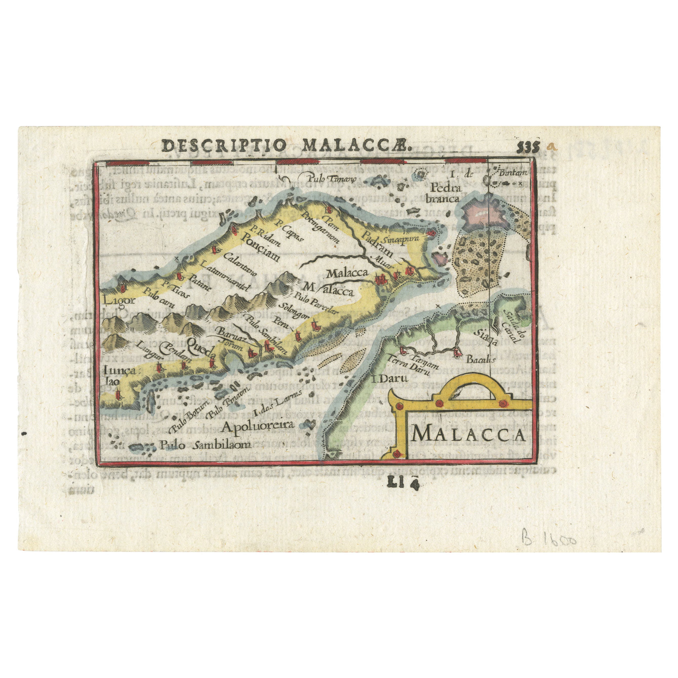
View AllRare Original Handcolored Miniature Map of Malaysia and Singapore, 1600
Located in Langweer, NL
Very handsome original old coloured copper engraving of Malaysia and Singapore, with parts of Sumatra, inc the island of Bangka and Bintam. Title of the map 'Description Malacca'. On...
Category
Antique Early 1600s Maps
Materials
Paper

$527 Sale Price
20% Off
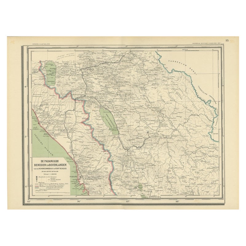
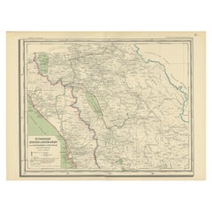
Antique Map of Padang, Sumatra, Indonesia, 1900
Located in Langweer, NL
Antique map titled 'De Padangsche Beneden-en Bovenlanden van de Koninginnedbaai tot Fort de Kock'. Old map of Padang, Sumatra. This map originates from 'Atlas van Nederlandsch Oost- ...
Category
20th Century Maps
Materials
Paper
Antique Map of the Region of Lampung, Sumatra, Indonesia, 1900
Located in Langweer, NL
Antique map of the region of Lampung, Sumatra. Also depicting part of Palembang and Java. This map originates from 'Atlas van Nederlandsch Oost- en West-Indië' by I. Dornseiffen.
A...
Category
20th Century Maps
Materials
Paper

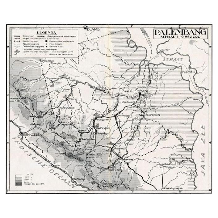
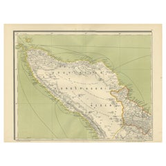
Antique Map of the Palembang Area, c.1900
Located in Langweer, NL
Antique map titled 'Palembang.' This map shows the Palembang area on the Indonesian island of Sumatra. With legend. Source unknown, to be determined. Published circa 1900.
Artists...
Category
Antique 19th Century Maps
Materials
Paper

$70 Sale Price
20% Off
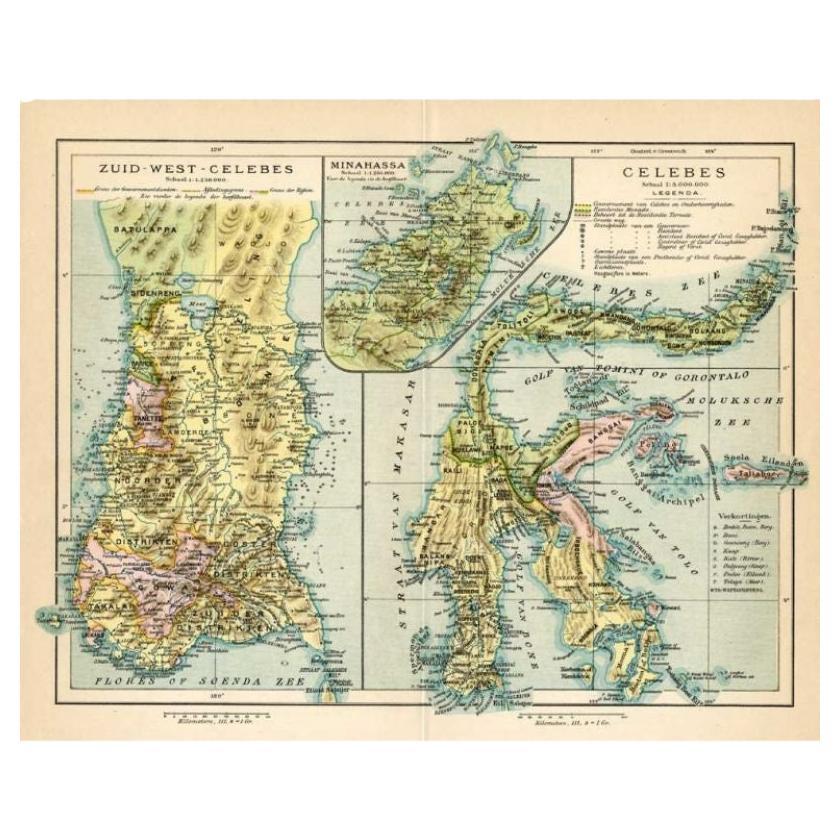
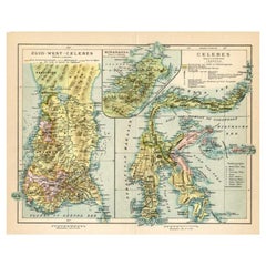
Antique Map of Sulawesi by Winkler Prins, c.1900
Located in Langweer, NL
Antique map titled 'Celebes.' (Sulawesi .) This map shows the Indonesian island of Sulawesi, one of the Sunda islands. With inset maps of South-west Sulawesi and Semenanjung Minahassa. Legend and scale. This map originates from 'De Grote Winkler Prins...
Category
20th Century Maps
Materials
Paper
$70 Sale Price
20% Off
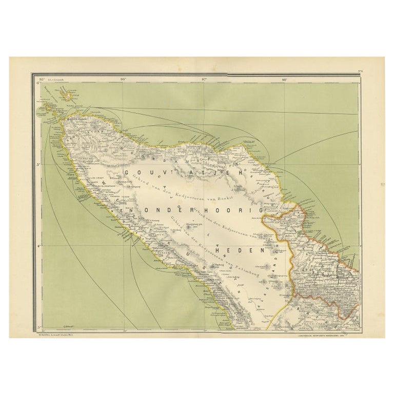
Antique Map of Aceh or Adjeh in Northern Sumatra, Indonesia, 1900
Located in Langweer, NL
Antique map of Aceh, Sumatra. This map originates from 'Atlas van Nederlandsch Oost- en West-Indië' by I. Dornseiffen.
Artists and Engravers: Published by Seyffardt's Boekhandel, A...
Category
20th Century Maps
Materials
Paper
You May Also Like
Central America. Century Atlas antique vintage map
Located in Melbourne, Victoria
'The Century Atlas. Central America.'
Original antique map, 1903.
Inset maps of 'The Country around Lake Nicaragua'.
Central fold as issued. Map name and number printed on the reve...
Category
Early 20th Century Victorian More Prints
Materials
Lithograph

Africa. North-West Part. Century Atlas antique vintage map
Located in Melbourne, Victoria
'The Century Atlas. Africa. Southern Part'
Original antique map, 1903.
Central fold as issued. Map name and number printed on the reverse corners.
Sheet 40cm by 29.5cm.
Category
Early 20th Century Victorian More Prints
Materials
Lithograph

Large Original Vintage Map of S.E Asia, with a Vignette of Singapore
Located in St Annes, Lancashire
Great map of South East Asia
Original color. Good condition
Published by Alexander Gross
Unframed.
Category
Vintage 1920s English Maps
Materials
Paper

Large Original Vintage Map of Mexico, circa 1920
Located in St Annes, Lancashire
Great map of Mexico
Original color.
Good condition
Published by Alexander Gross
Unframed.
Category
Vintage 1920s English Edwardian Maps
Materials
Paper
Large Original Antique Map of Madeira. 1894
Located in St Annes, Lancashire
Superb Antique map of Madeira
Published Edward Stanford, Charing Cross, London 1894
Original colour
Good condition
Unframed.
Free shipping
Category
Antique 1890s English Maps
Materials
Paper

Antique 1803 Italian Map of Asia Including China Indoneseia India
Located in Amsterdam, Noord Holland
Antique 1803 Italian Map of Asia Including China Indoneseia India
Very nice map of Asia. 1803.
Additional information:
Type: Map
Country of Manufacturing: Europe
Period: 19th centu...
Category
Antique 19th Century European Maps
Materials
Paper

$584 Sale Price
20% Off
More Ways To Browse
Blue John Antique
Lighthouse Antique
Antique Dutch Tins
Gilded Age Antiques
Japanese Compact
Portuguese Colonial Furniture
Maritime Antiques
Scottish Walnut
Antique Tin Sheets
Antique Church Artifacts
S Barton
Ecclesiastical Antiques
Vintage Scandanavian Chairs
19th Century Red Glass
Antique French Console Table Tables
Silver Bowl Large
Antique French Silk
Down Couch