Items Similar to Antique Map of the Palembang Area, c.1900
Want more images or videos?
Request additional images or videos from the seller
1 of 5
Antique Map of the Palembang Area, c.1900
About the Item
Antique map titled 'Palembang.' This map shows the Palembang area on the Indonesian island of Sumatra. With legend. Source unknown, to be determined. Published circa 1900.
Artists and Engravers: Anonymous.
Condition: Good, general age related toning; some light staining from handling. Please study image carefully.
Date: c.1900
Overall size: 31 x 24 cm.
Image size: 25.5 x 21 cm.
We sell original antique maps to collectors, historians, educators and interior decorators all over the world. Our collection includes a wide range of authentic antique maps from the 16th to the 20th centuries. Buying and collecting antique maps is a tradition that goes back hundreds of years. Antique maps have proved a richly rewarding investment over the past decade, thanks to a growing appreciation of their unique historical appeal. Today the decorative qualities of antique maps are widely recognized by interior designers who appreciate their beauty and design flexibility. Depending on the individual map, presentation, and context, a rare or antique map can be modern, traditional, abstract, figurative, serious or whimsical. We offer a wide range of authentic antique maps for any budget.
- Dimensions:Height: 9.45 in (24 cm)Width: 12.21 in (31 cm)Depth: 0 in (0.01 mm)
- Materials and Techniques:
- Period:
- Date of Manufacture:circa 1900
- Condition:
- Seller Location:Langweer, NL
- Reference Number:
About the Seller
5.0
Platinum Seller
These expertly vetted sellers are 1stDibs' most experienced sellers and are rated highest by our customers.
Established in 2009
1stDibs seller since 2017
1,932 sales on 1stDibs
Typical response time: <1 hour
- ShippingRetrieving quote...Ships From: Langweer, Netherlands
- Return PolicyA return for this item may be initiated within 14 days of delivery.
More From This SellerView All
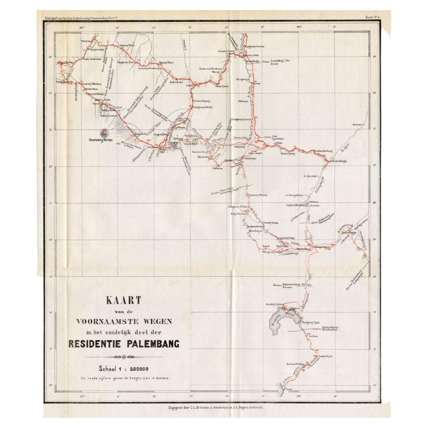
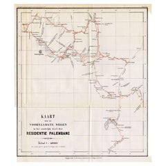
- Antique Map of the Main Roads of Palembang by Stemler, c.1875Located in Langweer, NLAntique map titled 'Kaart van de voornaamste wegen in het zuidelijke deel der Residentie Palembang.' This scarce map shows the main roads in Palembang on the Indonesian island of Sum...Category
Antique 19th Century Maps
MaterialsPaper
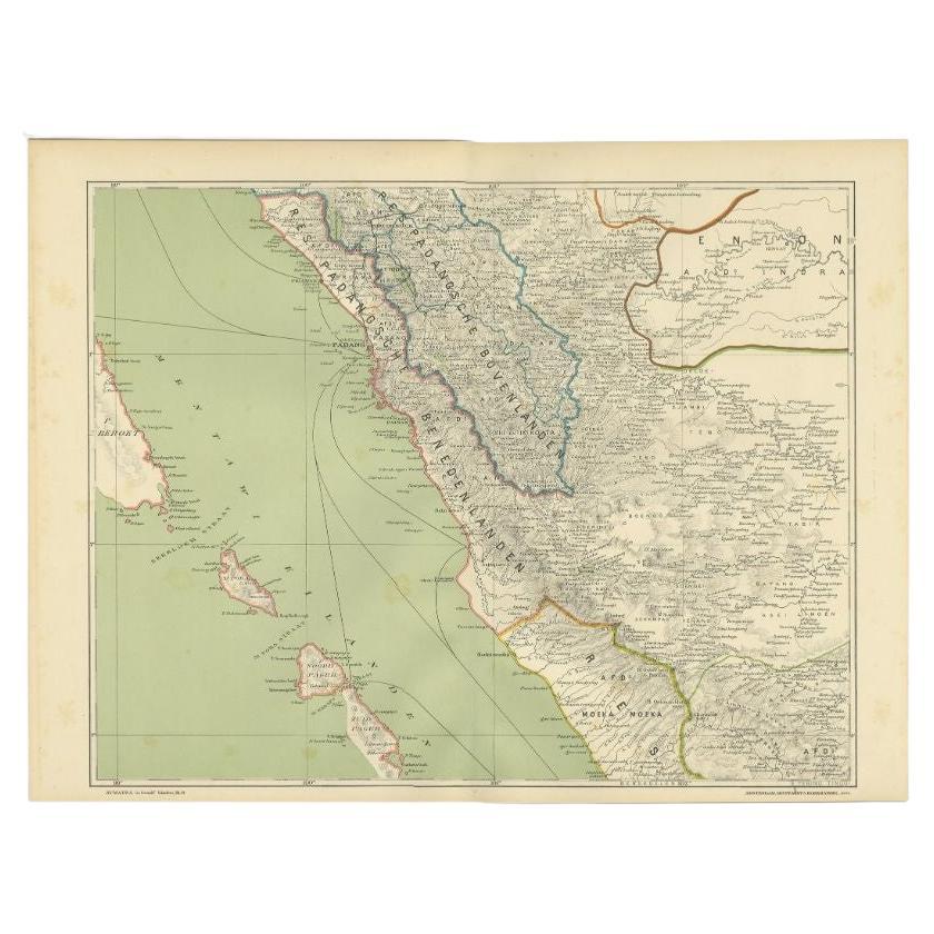
- Antique Map of the Mentawai Islands, Sumatra, 1900Located in Langweer, NLAntique map of the Mentawai Islands, Sumatra. Also depicting the region of Padang. This map originates from 'Atlas van Nederlandsch Oost- en West-Indië' by I. Dornseiffen. Artists ...Category
20th Century Maps
MaterialsPaper
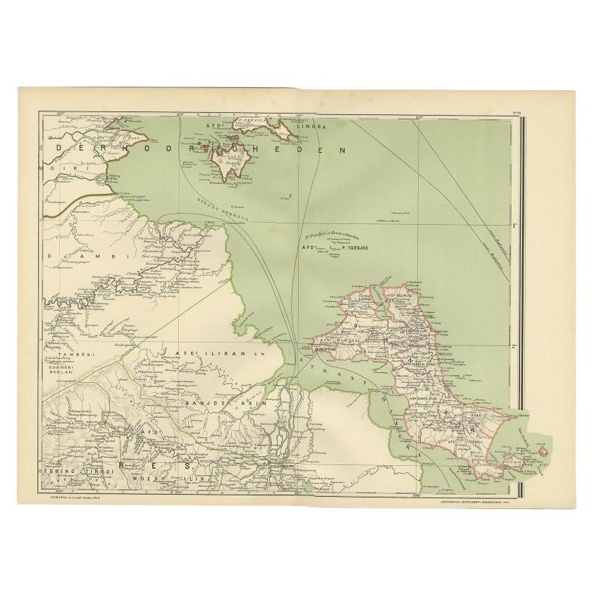
- Antique Map of the Region of Banjarmasin, Indonesia 1900Located in Langweer, NLAntique Map of the Region of Banyuasin, Sumatra. Also depicting Bangka/Banka island. This map originates from 'Atlas van Nederlandsch Oost- en West-Indië' by I. Dornseiffen. Artist...Category
20th Century Maps
MaterialsPaper
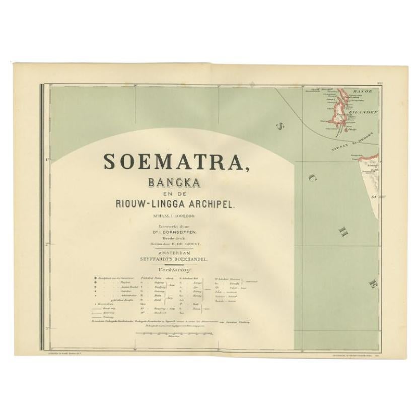
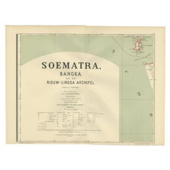
- Antique Map of the Batu Islands by Dornseiffen, 1900Located in Langweer, NLAntique map of the Batu Islands with the large title 'Soematra, Bangka en de Riouw-Lingga Archipel'. This map originates from 'Atlas van Nederlandsch Oost- en West-Indië' by I. Dorns...Category
20th Century Maps
MaterialsPaper
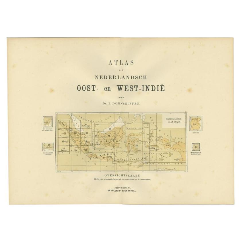
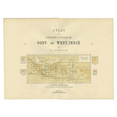
- Antique Map of the East Indies by Dornseiffen, 1900Located in Langweer, NLTitle page of 'Atlas van Nederlandsch Oost- en West-Indië' by I. Dornseiffen. It shows the regions of the various maps included in this atlas. Included are the Dutch East Indies and ...Category
20th Century Maps
MaterialsPaper
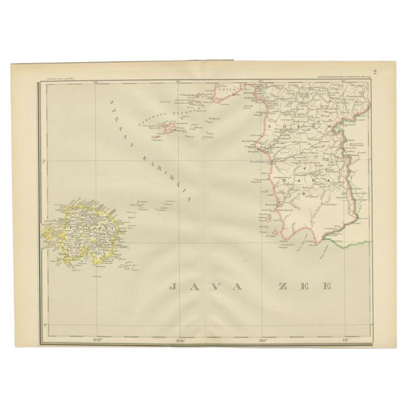
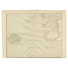
- Antique Map of the Java Sea by Dornseiffen, 1900Located in Langweer, NLAntique map of the Java Sea. Also depicts Bilitung, the Karimata Islands and Sukadana, Borneo. This map originates from 'Atlas van Nederlandsch Oost- en West-Indië' by I. Dornseiffen...Category
20th Century Maps
MaterialsPaper


You May Also Like
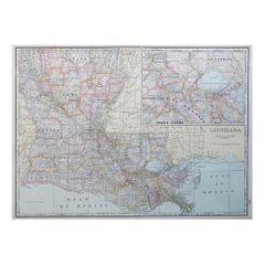
- Large Original Antique Map of Louisiana, USA, C.1900Located in St Annes, LancashireFabulous map of Louisiana. Original color. Engraved and printed by the George F. Cram Company, Indianapolis. Published, c.1900. Unframed. Repair ...Category
Antique 1890s American Maps
MaterialsPaper
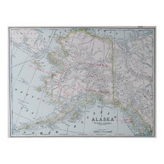
- Large Original Antique Map of Alaska, USA, C.1900Located in St Annes, LancashireFabulous map of Alaska Original color Engraved and printed by the George F. Cram Company, Indianapolis. Published, C.1900 Unframed Free shipping.Category
Antique 1890s American Maps
MaterialsPaper
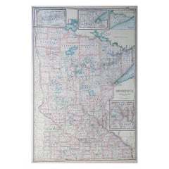
- Large Original Antique Map of Minnesota, USA, C.1900Located in St Annes, LancashireFabulous map of Minnesota Original color Engraved and printed by the George F. Cram Company, Indianapolis. Published, C.1900 Unframed Repair to a small tear bottom left corner ...Category
Antique 1890s American Maps
MaterialsPaper
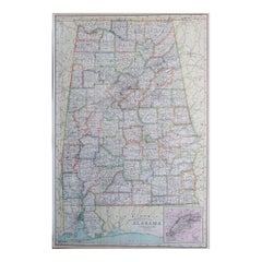
- Large Original Antique Map of Alabama, USA, C.1900Located in St Annes, LancashireFabulous map of Alabama Original color Engraved and printed by the George F. Cram Company, Indianapolis. Published, C.1900 Unframed Repair to a minor edge tear top left corner ...Category
Antique 1890s American Maps
MaterialsPaper
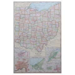
- Large Original Antique Map of Ohio, Usa, C.1900Located in St Annes, LancashireFabulous map of Ohio Original color. Engraved and printed by the George F. Cram Company, Indianapolis. Published, C.1900. Unframed. Free shipping.Category
Antique 1890s American Maps
MaterialsPaper
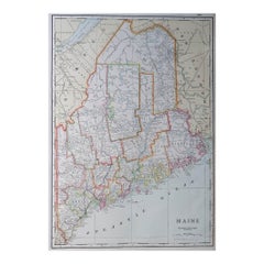
- Large Original Antique Map of Maine, USA, C.1900Located in St Annes, LancashireFabulous map of Maine Original color Engraved and printed by the George F. Cram Company, Indianapolis. Published, C.1900 Unframed Free shipping.Category
Antique 1890s American Maps
MaterialsPaper
Recently Viewed
View AllMore Ways To Browse
Antique Paper Light
Medieval Plate
Antique Depot
Kings Court
Large Framed Maps
Ships Log
Royal Carriage
Antique Map Australia
Australia Antique Map
Antique Australian Maps
Antique Australia Map
Antique Australian Map
Antique Maps Of Australia
Antique Map Of Australia
Antique Furniture In The Philippines
Antique Filipino
Large Framed Antique Maps
Antique Map Japan