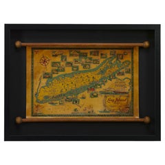
1964 Pictorial Map of Long Island by Catherine & E. Theodore Nelson
View Similar Items


Video Loading
Want more images or videos?
Request additional images or videos from the seller
1 of 8
1964 Pictorial Map of Long Island by Catherine & E. Theodore Nelson
$1,250List Price
About the Item
- Dimensions:Height: 20.38 in (51.77 cm)Width: 27.25 in (69.22 cm)Depth: 2.25 in (5.72 cm)
- Materials and Techniques:
- Place of Origin:
- Period:
- Date of Manufacture:1964
- Condition:Additions or alterations made to the original: Archival framing by Rio Grande Custom Framing in Colorado Springs, CO in March of 2023. Wear consistent with age and use. Minor fading.
- Seller Location:Colorado Springs, CO
- Reference Number:Seller: M2321stDibs: LU909734040942
About the Seller
4.9
Platinum Seller
Premium sellers with a 4.7+ rating and 24-hour response times
Established in 2010
1stDibs seller since 2011
461 sales on 1stDibs
Authenticity Guarantee
In the unlikely event there’s an issue with an item’s authenticity, contact us within 1 year for a full refund. DetailsMoney-Back Guarantee
If your item is not as described, is damaged in transit, or does not arrive, contact us within 7 days for a full refund. Details24-Hour Cancellation
You have a 24-hour grace period in which to reconsider your purchase, with no questions asked.Vetted Professional Sellers
Our world-class sellers must adhere to strict standards for service and quality, maintaining the integrity of our listings.Price-Match Guarantee
If you find that a seller listed the same item for a lower price elsewhere, we’ll match it.Trusted Global Delivery
Our best-in-class carrier network provides specialized shipping options worldwide, including custom delivery.More From This Seller
View All1854 Map of Massachusetts, Connecticut and Rhode Island, Antique Wall Map
Located in Colorado Springs, CO
This striking wall map was published in 1854 by Ensign, Bridgman & Fanning and has both full original hand-coloring and original hardware. This impression is both informative and highly decorative.
The states are divided into counties, outlined in red, green, and black, and subdivided into towns. Roads, canals, and railroad lines are prominently depicted, although they are not all labeled. The mapmakers also marked lighthouses, banks, churches, and prominent buildings, with a key at right. The map is an informative and comprehensive overview of the infrastructural development of New England prior to the Civil War. Physical geographies depicted include elevation, conveyed with hachure marks, rivers and lakes. The impression features an inset map of Boston...
Category
Antique 19th Century American Maps
Materials
Paper

1864 Map of North America, Antique Hand-Colored Map, by Adolphe Hippolyte Dufour
Located in Colorado Springs, CO
Offered is a map of North America entitled Amerique du Nord from 1864. This rare, separately published wall map was produced by Adolphe Hippolyte Dufour. This map includes vibrant an...
Category
Antique 1860s French Maps
Materials
Paper

1859 "Map of the United States of America..." by J. H. Colton
By J.H. Colton
Located in Colorado Springs, CO
Presented is an 1859 “Map of the United States of America, the British Provinces, Mexico, the West Indies and Central America with Part of...
Category
Antique 1850s American Maps
Materials
Paper

Plan of Paris, France, by A. Vuillemin, Antique Map, 1845
Located in Colorado Springs, CO
This large and detailed plan of Paris was published by Alexandre Vuillemin in 1845. The map conveys a wonderful amount of information and is decorated throughout with pictorial vigne...
Category
Antique 1840s American Maps
Materials
Paper

1840 Map of the City of Washington Published by William M. Morrison
Located in Colorado Springs, CO
This map, printed in 1840, is a detailed representation of Washington, D.C. in the mid-19th century. The map shows block numbers, wards, and government buildings as well as details o...
Category
Antique 1840s American Federal Maps
Materials
Paper

1868 "Lloyd's Topographical Railway Map of North America..." Hanging Wall Map
Located in Colorado Springs, CO
Presented is “Lloyd's Topographical Railway Map of North-America, or the United States Continent in 1900.” This map was published by J. T. Lloyd, in New York, in 1868. A large, hangi...
Category
Antique 1860s American Late Victorian Maps
Materials
Linen, Paper

You May Also Like
The Order of Things by Fashion Photgrapher Schoerner
By Schoerner
Located in NYC, NY
A unique book first edition print set on a circular format retains its original case.
Category
Late 20th Century American Shadow Boxes
Materials
Plastic, Paper

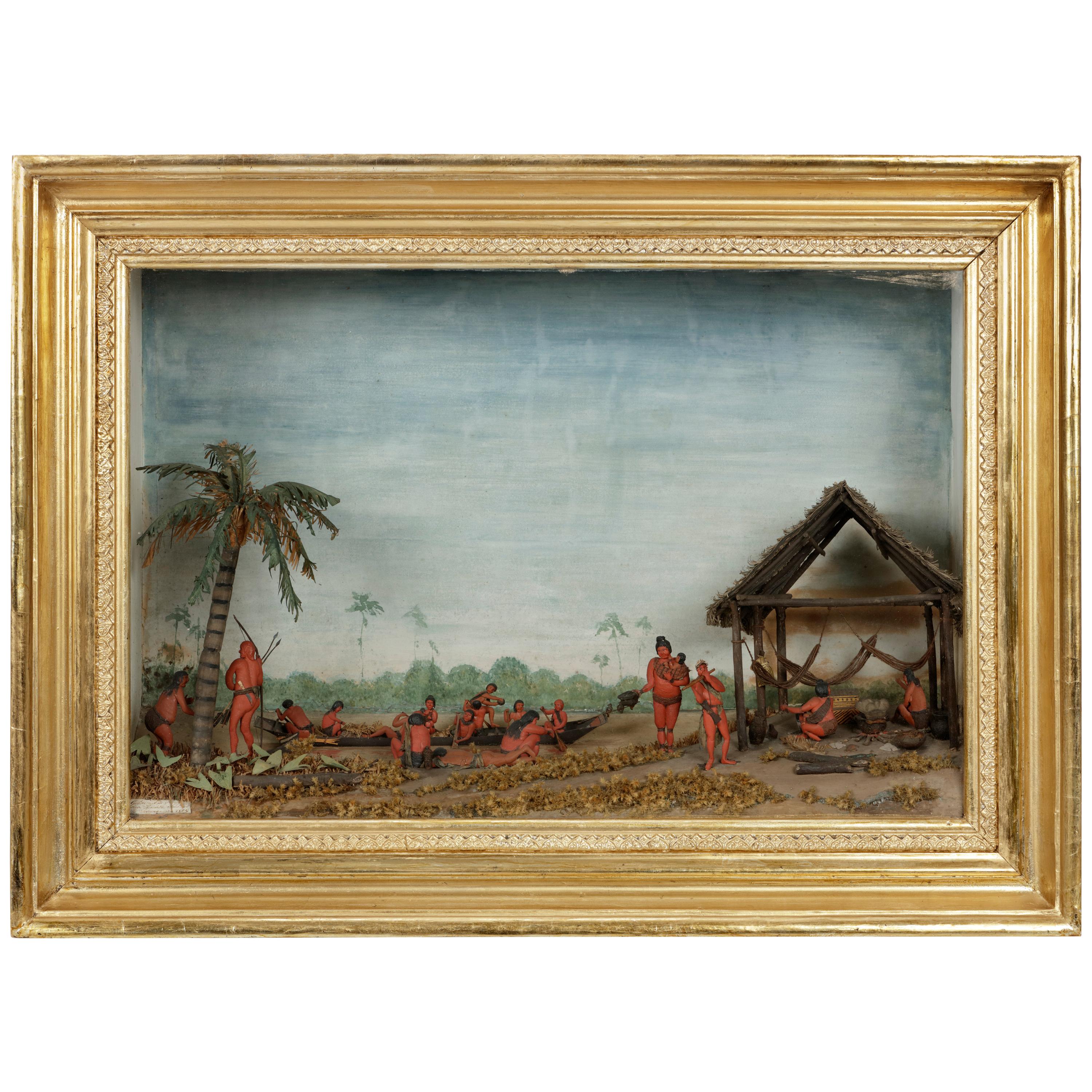
Rare Anthropological Diorama of Carib Indigenous by Hendrik Schouten
Located in Amsterdam, NL
Hendrik Samuel Schouten (1785-1840)
A unique diorama depicting Carib Indigenous at the river side
Wood, paint on paper, twigs and dried moss
Measures: H. 51 x W. 69.5 x D. 20 cm
Note:
This is the only known diorama by Hendrik Schouten. He became a planter and inherited the Jagtlust plantation from his grandfather Samuel Loske. His older brother Gerrit Schouten...
Category
Antique Early 18th Century Models and Miniatures
Materials
Twig, Wood, Giltwood, Paint, Paper

Large School Teaching Display Anthill of the Red Wood Ant
Located in Berghuelen, DE
Large School Teaching Display Anthill of the Red Wood Ant
A vintage school teaching glass display of the anthill of the red wood ant. It shows the hill and inhabitants thereof, the ...
Category
Vintage 1950s German Scientific Instruments
Materials
Glass, Wood

Gothic Style Huge Triptych Shadow Box/Display Of Orthodox Church Silver Icons
Located in Guaynabo, PR
This is a Gothic style huge triptych shadow box/display of an Orthodox Church silver icons. The triptych is a large ogee shaped arc closed display made of heavy wood and glass. When you open the doors, it features some icons painted on wood and covered by an embossed and chased silver oklads with some gilt areas. They are framed by some red velvet. In the center, there are two icons who represent St.Paul and St.Peter; above them is the Almighty God...
Category
Antique Late 19th Century Unknown Gothic Religious Items
Materials
Silver
$10,000 Sale Price
20% Off
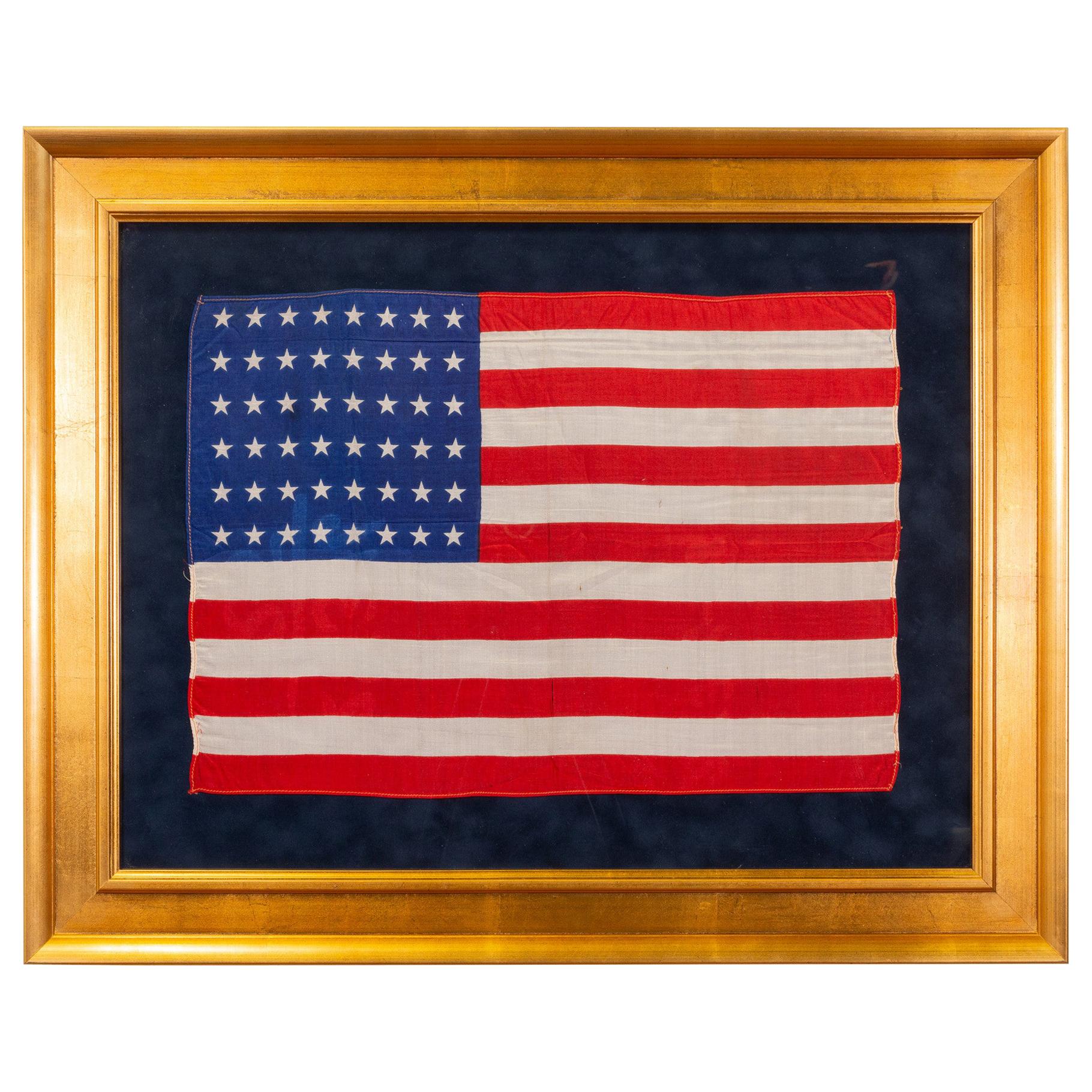
Vintage 1912 Arizona and New Mexico Statehood Flag
Located in Coeur d'Alene, ID
25th Design Patriotic American silk flag with 48 stars. Arizona Statehood Feb 14, 1912; New Mexico Statehood Jan 6, 1912
Period: 1912
Origin: United States
Size: 12" x 17".
Family ...
Category
Vintage 1910s American Historical Memorabilia
Materials
Silk

Sea Life and Shell Diorama /Shadow Box
Located in Douglas Manor, NY
3-715 Beautiful sea life diorama including sea shells various crustaceans ,seahorse starfish encased in a walnut frame under glass.
Brass hanging ring
Category
Vintage 1950s Nautical Objects
Materials
Shell

$575 Sale Price
41% Off