Items Similar to Antique 1743 Map – Travels of Jesus Christ & Apostles by Seutter


Video Loading
Want more images or videos?
Request additional images or videos from the seller
1 of 13
Antique 1743 Map – Travels of Jesus Christ & Apostles by Seutter
$1,614.14
$2,017.6820% Off
£1,190.41
£1,488.0220% Off
€1,352
€1,69020% Off
CA$2,230.99
CA$2,788.7420% Off
A$2,481.01
A$3,101.2620% Off
CHF 1,302.20
CHF 1,627.7520% Off
MX$30,254.69
MX$37,818.3720% Off
NOK 16,457.19
NOK 20,571.4920% Off
SEK 15,429.27
SEK 19,286.5920% Off
DKK 10,292.99
DKK 12,866.2320% Off
About the Item
Antique 1743 Map – Travels of Jesus Christ & Apostles by Seutter
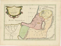
This is an original antique map titled “Carte des Voyages de Notre Seigneur Jesus-Christ et des Actes des Apotres St. Pierre et St. Paul,” created by Matthäus Seutter and published in Augsburg circa 1743. The map illustrates the Holy Land and wider eastern Mediterranean with a focus on biblical geography, depicting the travels of Jesus Christ and the Apostles, particularly St. Peter and St. Paul.
The central map covers the eastern Mediterranean from Italy and Greece to Asia Minor, Syria, and Judea, detailing regions relevant to New Testament narratives. It is beautifully hand coloured, with routes marked to trace the journeys of Christ and his Apostles. The seas, islands, and major ancient cities are labelled in Latin, reflecting the scholarly audience of the period.
At the lower left, an inset shows Judea under Herod the Great, providing detailed divisions of tribal territories and key towns of biblical history. To the right is an inset plan of Jerusalem, mapping its sacred landmarks and city layout during the Second Temple period. The map also includes a detailed table of place names and biblical references in the upper right for study and cross-reference.
The lower centre features an elaborate baroque cartouche with figures of scribes and scholars, symbols of Christian faith such as the cross and chalice, and radiant divine light. This decorative cartouche is characteristic of Seutter’s engraving style, adding dramatic artistic appeal to his cartographic works.
Matthäus Seutter (1678–1757) was one of the most prominent German mapmakers of the 18th century, appointed Imperial Geographer to Emperor Charles VI. His maps are prized for their rich detail, decorative colouring, and elaborate cartouches that blend art with geographical scholarship.
Condition:
Very good condition. Clean strong impression with vivid original hand colouring. Light age toning to edges, minor spotting in margins, and faint centre fold line as issued, with no tears or repairs noted. Fully suitable for framing.
Framing tips:
Frame in a gilt or dark wood frame to complement the vibrant hand colouring and baroque cartouche. Use a wide off-white or cream archival mat to enhance the map’s presentation and preserve its edges. UV-protective glass is recommended to protect the paper and pigments from fading over time.
- Dimensions:Height: 21.66 in (55 cm)Width: 26.3 in (66.8 cm)Depth: 0.01 in (0.2 mm)
- Materials and Techniques:Paper,Engraved
- Place of Origin:
- Period:
- Date of Manufacture:1743
- Condition:Very good condition. Clean strong impression with vivid original hand colouring. Light age toning to edges, minor spotting in margins, and faint centre fold line as issued, with no tears or repairs noted. Fully suitable for framing.
- Seller Location:Langweer, NL
- Reference Number:Seller: BG-14043-91stDibs: LU3054345665372
About the Seller
5.0
Recognized Seller
These prestigious sellers are industry leaders and represent the highest echelon for item quality and design.
Platinum Seller
Premium sellers with a 4.7+ rating and 24-hour response times
Established in 2009
1stDibs seller since 2017
2,577 sales on 1stDibs
Typical response time: <1 hour
- ShippingRetrieving quote...Shipping from: Langweer, Netherlands
- Return Policy
Authenticity Guarantee
In the unlikely event there’s an issue with an item’s authenticity, contact us within 1 year for a full refund. DetailsMoney-Back Guarantee
If your item is not as described, is damaged in transit, or does not arrive, contact us within 7 days for a full refund. Details24-Hour Cancellation
You have a 24-hour grace period in which to reconsider your purchase, with no questions asked.Vetted Professional Sellers
Our world-class sellers must adhere to strict standards for service and quality, maintaining the integrity of our listings.Price-Match Guarantee
If you find that a seller listed the same item for a lower price elsewhere, we’ll match it.Trusted Global Delivery
Our best-in-class carrier network provides specialized shipping options worldwide, including custom delivery.More From This Seller
View AllAntique Map of the Holy Land Described in the Old and New Testament, ca.1660
Located in Langweer, NL
Antique map titled 'Geographiae Sacrae ex Veteri et Novo Testamento Desumptae Tabula Prima quae Totius Orbis Partes Continet.'
Map of the lands described in the Old and New Testame...
Category
Antique 1660s Maps
Materials
Paper

$811 Sale Price
20% Off
Antique Map Eastern Mediterranean by D. Stoopendaal 'circa 1710'
Located in Langweer, NL
Antique map Middle East titled 'De Beschryving van de Reysen Pauli en van de Andere Apostelen'. Antique map of the Eastern Mediterranean with details of the travels by Apostle Paul...
Category
Antique Early 18th Century Dutch Maps
Materials
Paper

$334 Sale Price
20% Off
Antique Map of Alexander the Great's Empire & Campaigns, de Vaugondy, 1753
Located in Langweer, NL
Antique Map of Alexander the Great's Empire & Campaigns, de Vaugondy, 1753
This rare and elegantly engraved map, titled "Antiquor Imperiorum Tabula, in qua Prae Caeteris, Macedonicu...
Category
Antique Mid-18th Century European Maps
Materials
Paper
18th-Century Map of the Eastern Roman Empire by Henri Chatelain, c. 1719
Located in Langweer, NL
Title: 18th-Century Map of the Eastern Roman Empire by Henri Chatelain, c. 1719
Description: This intricately detailed map, titled *Nouvelle Carte pour Servir à l'Histoire de l'Empi...
Category
Antique 1710s Maps
Materials
Paper
Antique Bible Map of the Middle East by A. Schut, 1743
Located in Langweer, NL
Antique map titled 'De Gelegentheyt van 't Paradys en 't Landt Canaan'. Dutch Bible map covering the region between the Mediterranean and the Persian Gulf, ...
Category
Antique Mid-18th Century Maps
Materials
Paper

$525 Sale Price
20% Off
17th-Century Map of the Latin Patriarchate of Jerusalem by Melchior Tavernier
Located in Langweer, NL
Title: 17th-Century Map of the Latin Patriarchate of Jerusalem by Melchior Tavernier
Description: This rare 17th-century map by Melchior Tavernier illustrates the geographical ext...
Category
Antique 1640s Maps
Materials
Paper
You May Also Like
1718 Ides & Witsen Map "Route D'amsterdam a Moscow Et De La Ispahan Et Gamron
Located in Norton, MA
1718 Ides & Witsen map, entitled
"Route D'Amsterdam A Moscow Et De La Ispahan Et Gamron,"
Ric.b005
Subject: Eastern Europe and Central Asia
Period: 1718 (published)
Publicati...
Category
Antique Early 18th Century Dutch Maps
Materials
Paper

1633 Map "La Souverainete De Sedan Et De Raucourt, Et La Prevoste Ric0011
Located in Norton, MA
1653 map entitled
"La Souverainete de Sedan et de Raucourt, et la Prevoste de Doncheri,"
Ric0011
Description:
Lovely map centered on Sedan and Doncheri and the Meuze River fr...
Category
Antique 17th Century Dutch Maps
Materials
Paper

1627 Hendrik Hondius Map Entitled "Vltoniae Orientalis Pars, " Ric.a009
Located in Norton, MA
1627 Hendrik Hondius map entitled
"Vltoniae orientalis pars,"
Ric.a009
Title:
Vltoniae orientalis : pars
Title (alt.) :
Ultoniae orientalis pars
Creator:
Mercator, Gerh...
Category
Antique 17th Century Dutch Maps
Materials
Paper

Mediterranean and Adriatic Seas: Original 18th Century Hand-colored Map by Bowen
Located in Alamo, CA
This is an original 18th century hand-colored map entitled "An Accurate Chart of The Mediterranean and Adriatic Sea's; with the Archipelago & Part of the Black Sea. Exhibiting all th...
Category
Mid-18th Century Old Masters Landscape Prints
Materials
Engraving

Southern & Eastern Europe: A Large 17th C. Hand-colored Map by Sanson & Jaillot
By Nicholas Sanson d'Abbeville
Located in Alamo, CA
This large hand-colored map entitled "Estats de L'Empire des Turqs en Europe, ou sont les Beglerbeglicz our Gouvernements" was originally created by Nicholas Sanson d'Abbeville and this version was published by Hubert Jaillot in "Atlas Nouveau" in Paris in 1692. It depicts the territories of the Ottoman Empire in Europe, predominantly Eastern Europe. Highlights include, the Mediterranean Sea, the Adriatic Sea, the Black Sea, the Dalmation Coast including present day Croatia, Bosnia and Herzegovina, Montenegro, Serbia, Slovenia, Italy, Greece, North Macedonia, Turkey, Romania, Hungary, Albania, Kosovo, Bulgaria, Transylvania, Moldova and southern portions of France, Switzerland, Germany, and Poland..
The map consists of two sheets joined as one along a vertical joint. The map has original hand-coloring. It is printed on antique hand-made laid, chain-linked paper with wide margins. The sheet measures 24.88" high and 38" wide. There is a central vertical joint, as issued. The map is in very good condition.
Nicholas Sanson d'Abbeville (1600-1667) was one of the greatest French cartographather of French cartography. Sanson opened his first printing business in Paris in 1638. The king recognized his skill and knowledge and made him the official geographer to the court. He eventually served two kings in this capacity. Sanson was succeeded by his sons and son...
Category
1690s Landscape Prints
Materials
Engraving

Antique Map - Mar Di Athiopia - Etching by Johannes Janssonius - 1650s
By Johannes Janssonius
Located in Roma, IT
Antique Map - Mar Di Athiopia is an antique map realized in 1650 by Johannes Janssonius (1588-1664).
The Map is Hand-colored etching, with coeval watercolorang.
Good conditions wit...
Category
1650s Modern Figurative Prints
Materials
Etching

More Ways To Browse
Imperial German
Baroque Cartouche
Antique Ancient Key
Antique Chalice
Antique Chalices
Imperial Glass Works
Antique Imperial Furniture Table
18th Century German Table
Antique Scribe
Antique Table Plans
Chalice Used
Ancient Greek Cross
Antique Table Mats
Antique Glass Chalice
Syrian Table Tables
Syrian Table
Apostle Paul
Gilt Chalice