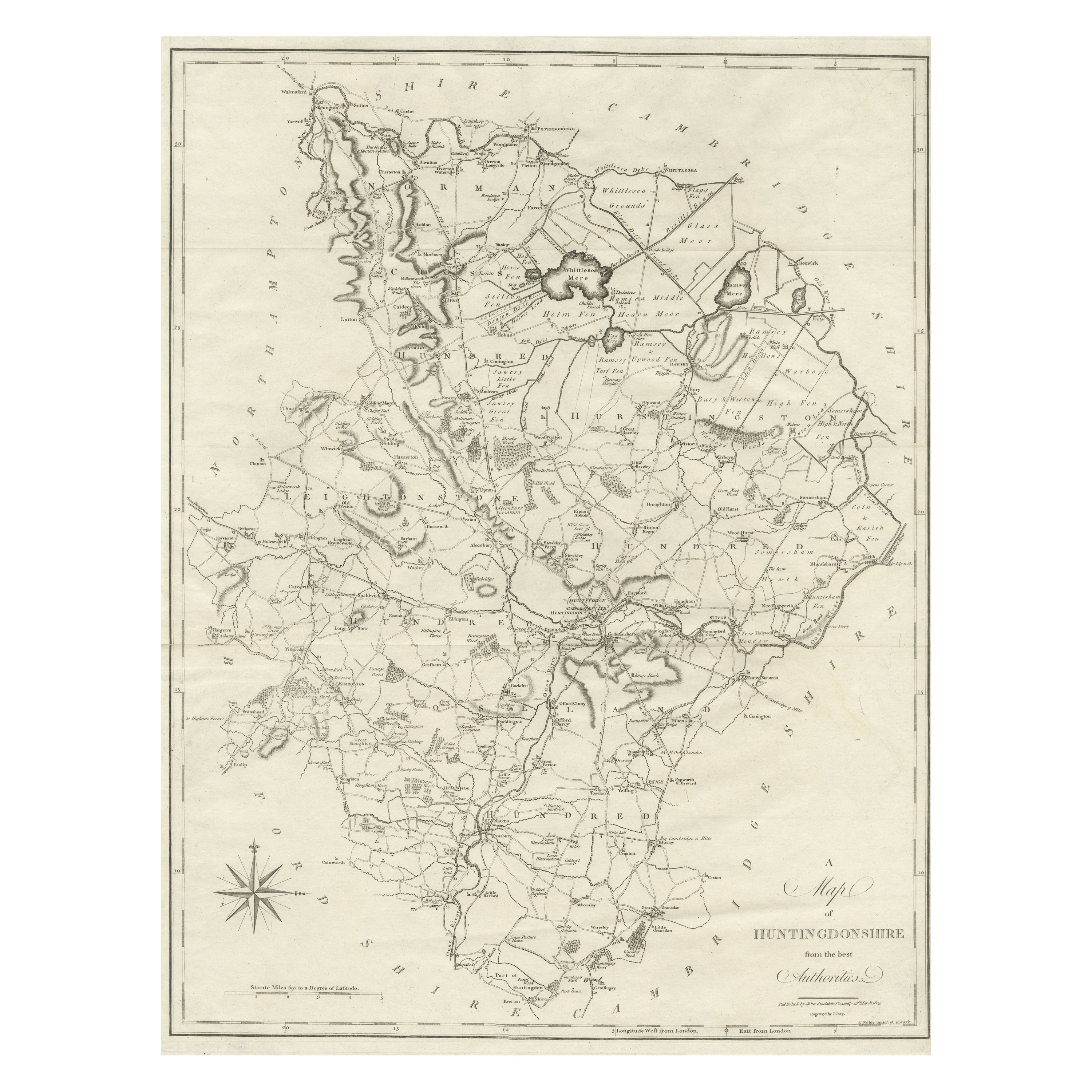
Items Similar to Antique Decorative County Map of Huntingdonshire, England, 1804
Want more images or videos?
Request additional images or videos from the seller
1 of 6
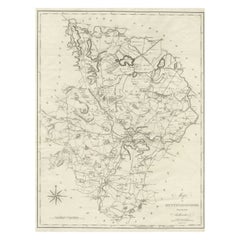
Antique Decorative County Map of Huntingdonshire, England, 1804
$311.79
$389.7320% Off
£231.94
£289.9220% Off
€260
€32520% Off
CA$426.94
CA$533.6820% Off
A$474.70
A$593.3820% Off
CHF 247.86
CHF 309.8320% Off
MX$5,778.28
MX$7,222.8520% Off
NOK 3,162.63
NOK 3,953.2820% Off
SEK 2,963.23
SEK 3,704.0420% Off
DKK 1,979.24
DKK 2,474.0520% Off
Shipping
Retrieving quote...The 1stDibs Promise:
Authenticity Guarantee,
Money-Back Guarantee,
24-Hour Cancellation
About the Item
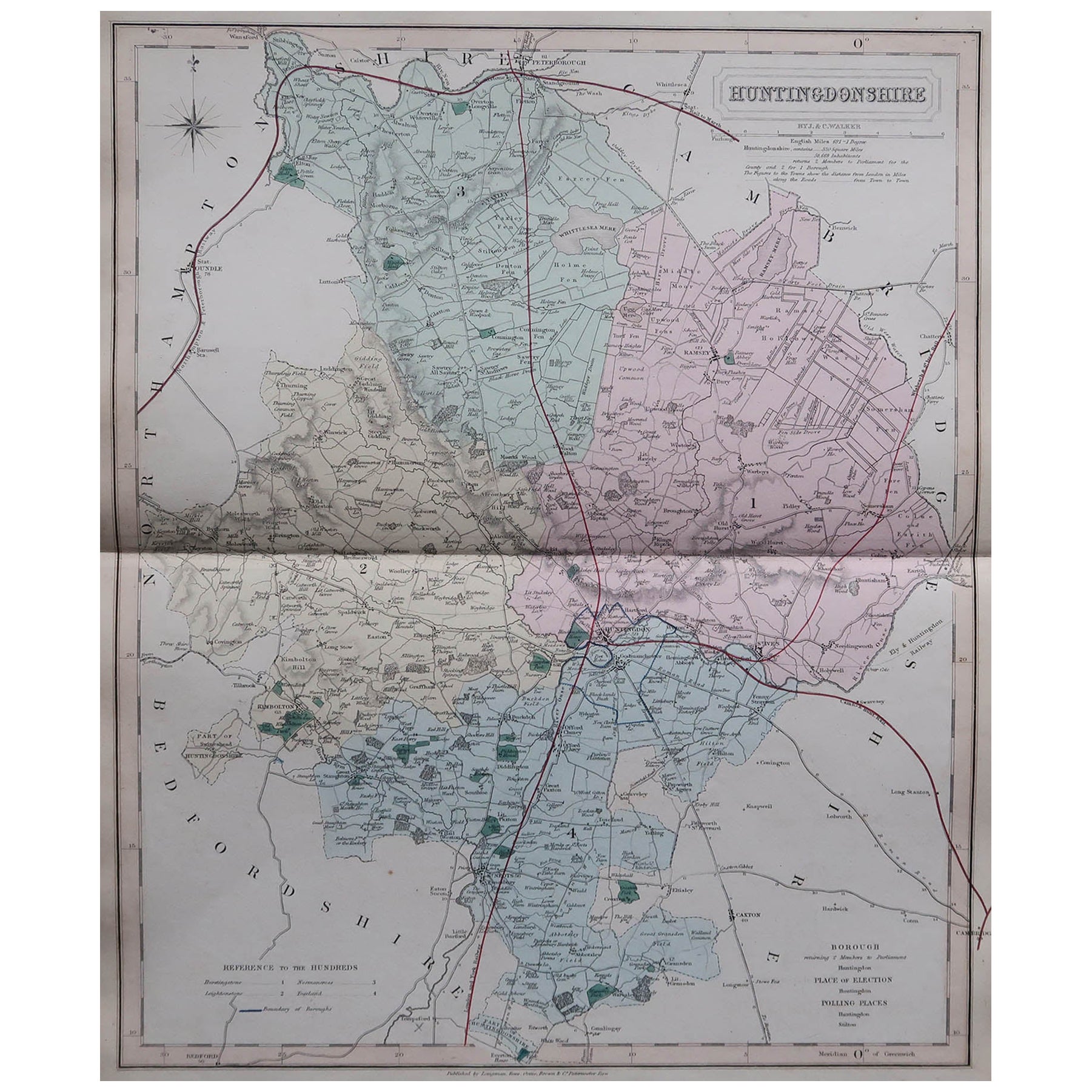
Antique county map of Huntingdonshire first published c.1800. Cities illustrated include Kimbolton, Chesterton, Folkesworth, and Great Stewkeley.
Charles Smith was a cartographer working in London from circa 1800. His maps were finely engraved on copper and featured beautiful hand colouring. The county maps were initially issued as single sheets for travelers from 1800. In 1804 they were published as an atlas, Smith's New English Atlas.
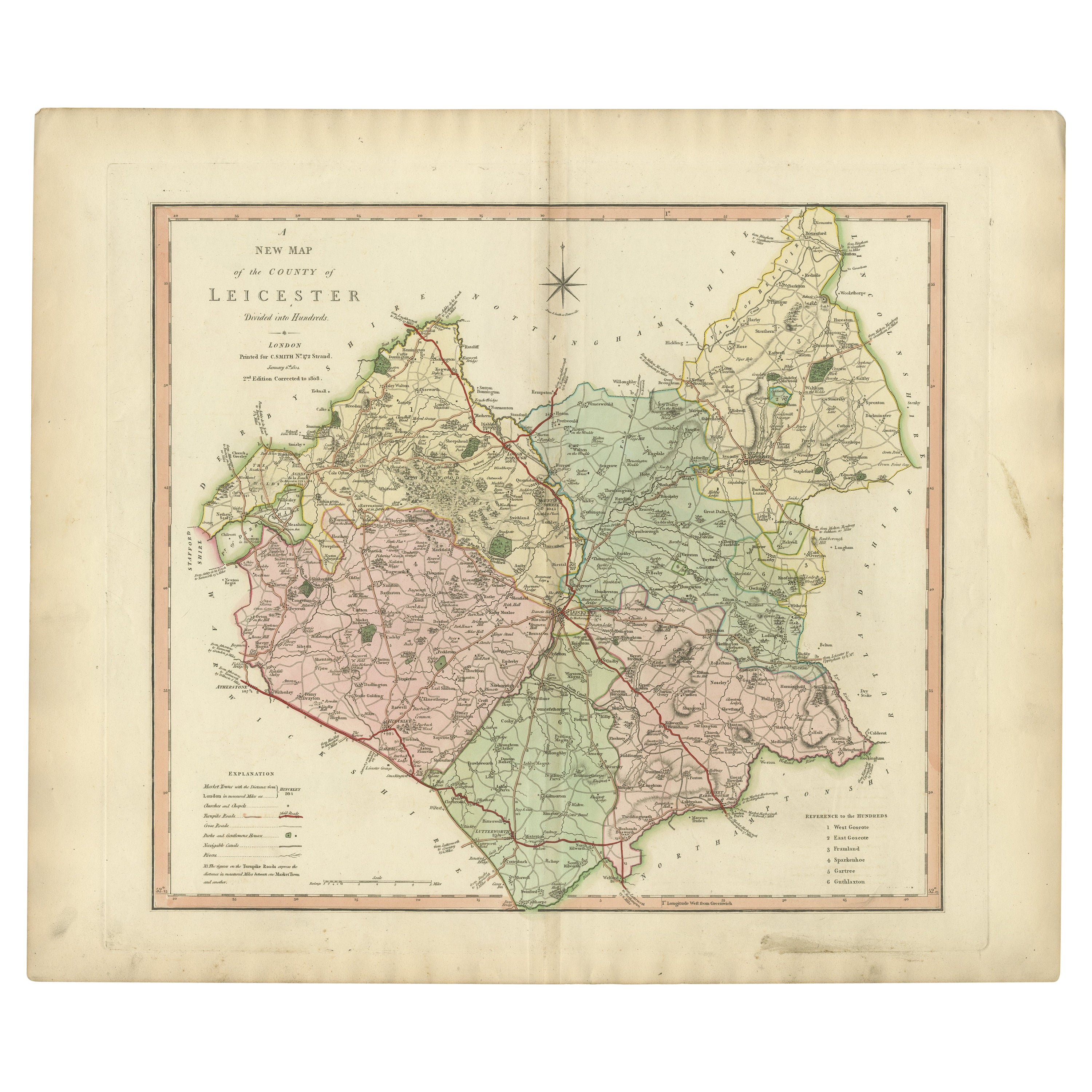
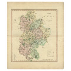
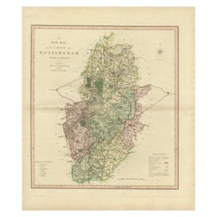
The maps are large and contain information required by a traveler of the time. All the principal turnpike roads are shown with distances from town to town. The local administrative divisions, such as the hundreds, are indicated by different colours. The hundred was of Saxon origin and was an area of approximately 100 households. As its head was an Elderman who was held responsible for supplying fully equipped men for the King in times of war and for the administration of justice. The hundred court was where justice was administered and by the 13th century they were held 12 times a year in a meeting place in the principal town. Local issues were also discussed here and decisions made, the town usually giving its name to the hundred.
- Dimensions:Height: 25.2 in (64 cm)Width: 21.26 in (54 cm)Depth: 0 in (0.02 mm)
- Materials and Techniques:Paper,Engraved
- Period:
- Date of Manufacture:1804
- Condition:Wear consistent with age and use. General age-related toning with some minor foxing. Small tears outside the plate. Contemporary colouring. Folding line, as issued, a bit discoloured, but still a very decorative representable map of over 200 years old. Please study image carefully.
- Seller Location:Langweer, NL
- Reference Number:Seller: BG-12924-91stDibs: LU3054326993572
About the Seller
5.0
Recognized Seller
These prestigious sellers are industry leaders and represent the highest echelon for item quality and design.
Platinum Seller
Premium sellers with a 4.7+ rating and 24-hour response times
Established in 2009
1stDibs seller since 2017
2,510 sales on 1stDibs
Typical response time: <1 hour
- ShippingRetrieving quote...Shipping from: Langweer, Netherlands
- Return Policy
Authenticity Guarantee
In the unlikely event there’s an issue with an item’s authenticity, contact us within 1 year for a full refund. DetailsMoney-Back Guarantee
If your item is not as described, is damaged in transit, or does not arrive, contact us within 7 days for a full refund. Details24-Hour Cancellation
You have a 24-hour grace period in which to reconsider your purchase, with no questions asked.Vetted Professional Sellers
Our world-class sellers must adhere to strict standards for service and quality, maintaining the integrity of our listings.Price-Match Guarantee
If you find that a seller listed the same item for a lower price elsewhere, we’ll match it.Trusted Global Delivery
Our best-in-class carrier network provides specialized shipping options worldwide, including custom delivery.More From This Seller
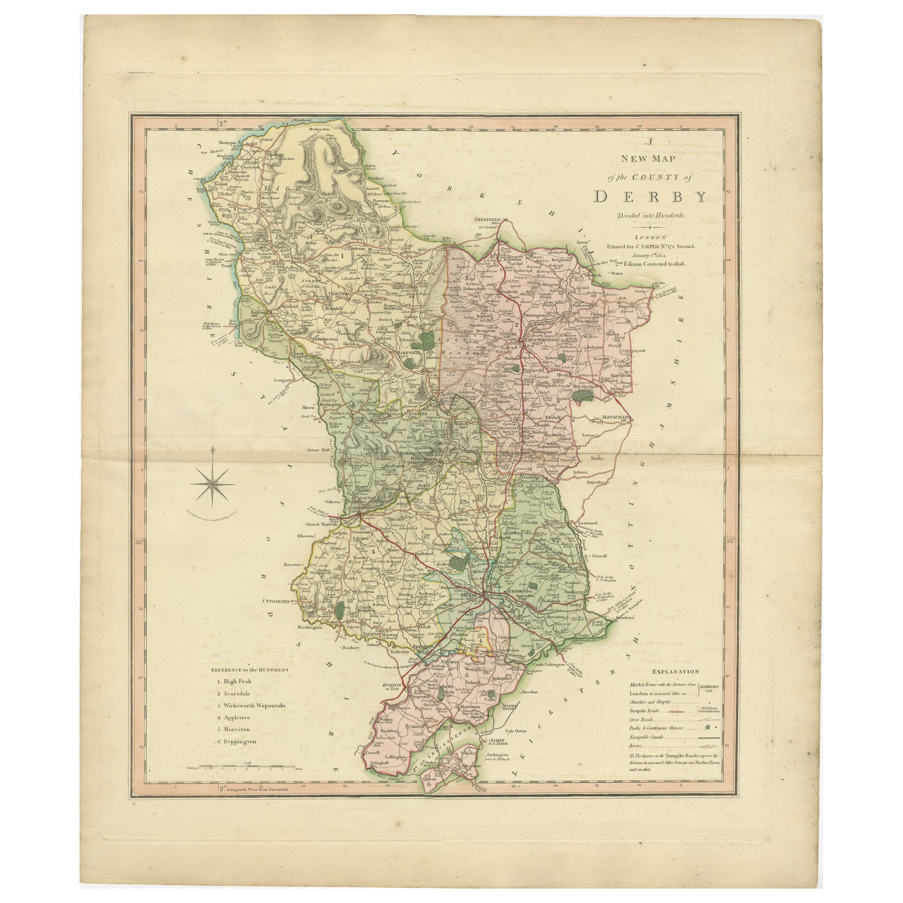
View AllAntique County Map of Derbyshire, England, 1804
Located in Langweer, NL
Antique county map of Derbyshire first published, circa 1800. Villages, towns, and cities illustrated include Chesterfield, Wirksworth, Derby, and ...
Category
Antique Early 1800s Maps
Materials
Paper

$311 Sale Price
20% Off
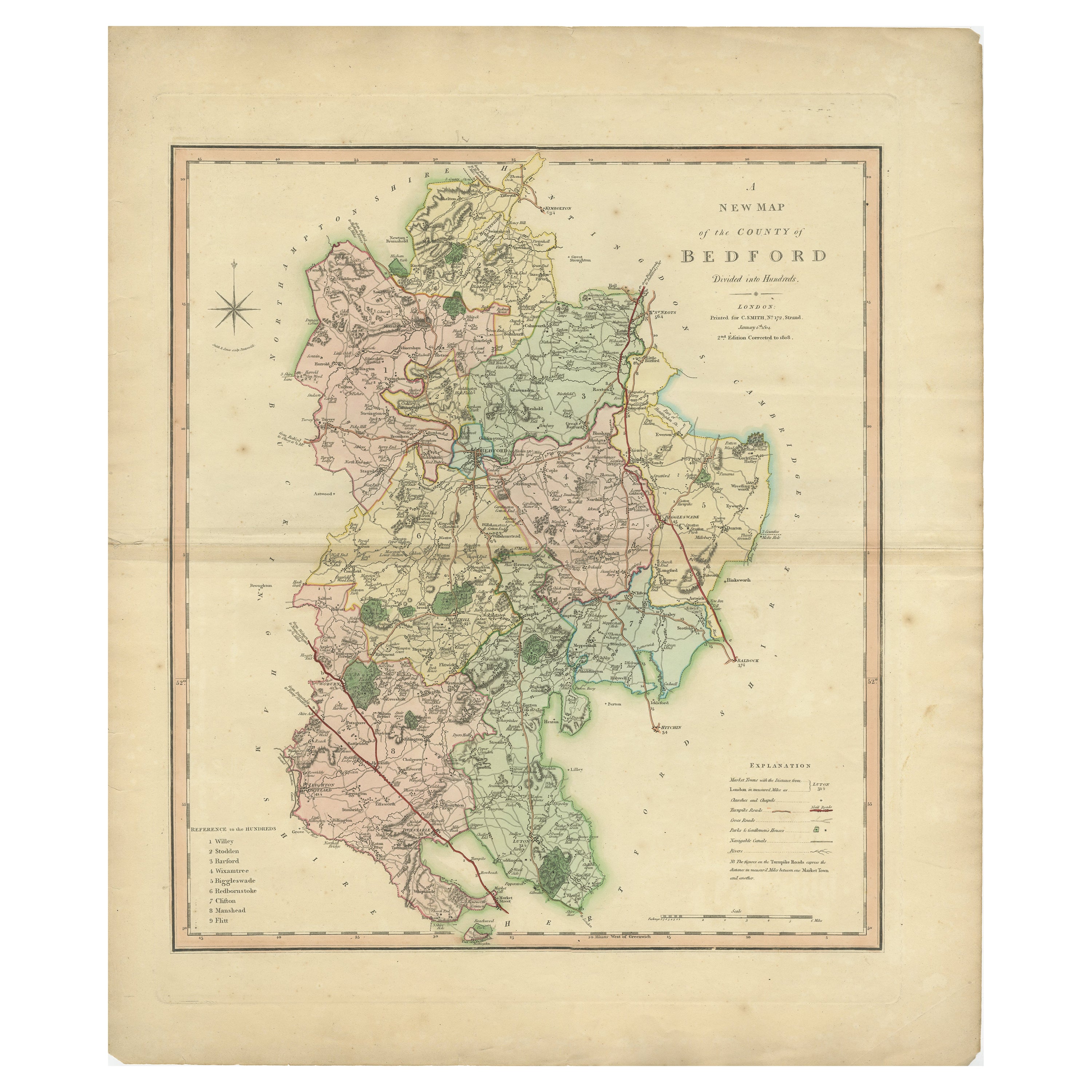
Antique Colourful and Decorative County Map of Bedfordshire, England, 1804
Located in Langweer, NL
Antique county map of Bedfordshire first published c.1800. Villages, towns, and cities illustrated include Bedford, Todington, and Potton.
Charl...
Category
Antique Early 1800s Maps
Materials
Paper
$311 Sale Price
20% Off
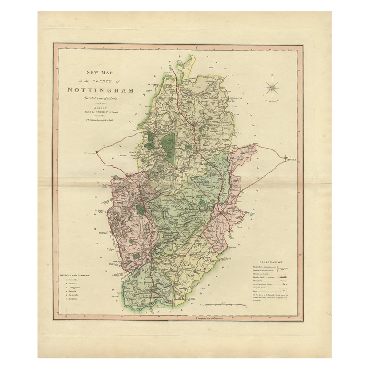
Antique Decorative Map of The County of Nottinghamshire, England, 1804
Located in Langweer, NL
Antique county map of Nottinghamshire first published c.1800. Villages, towns, and cities illustrated include Worksop, Neware, Tuxford, and Maplebe...
Category
Antique Early 1800s Maps
Materials
Paper
$311 Sale Price
20% Off
Large Antique County Map of Huntingdonshire, England
Located in Langweer, NL
Antique map titled 'A Map of Huntingdonshire from the best Authorities'. Original old county map of Huntingdonshire, England. Engraved by John Cary. Originates from 'New British Atla...
Category
Antique Early 19th Century Maps
Materials
Paper
$220 Sale Price
20% Off
Antique County Map of Leicestershire, England, 1804
Located in Langweer, NL
Antique county map of Leicestershire first published c.1800. Villages, towns, and cities illustrated include Lutterworth, Ashby, Hinkley, and Marke...
Category
Antique Early 1800s Maps
Materials
Paper
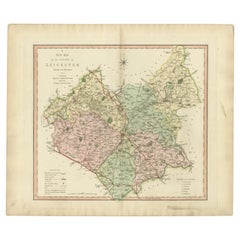
$311 Sale Price
20% Off
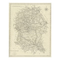
Large Antique County Map of Wiltshire, England, 1805
Located in Langweer, NL
Antique map titled 'A Map of Wiltshire from the best Authorities'. Original old county map of Wiltshire, England. Engraved by John Cary. Originates from 'New British Atlas' by John S...
Category
Antique Early 19th Century Maps
Materials
Paper
You May Also Like
Original Antique English County Map, Huntingdonshire, J & C Walker, 1851
Located in St Annes, Lancashire
Great map of Huntingdonshire
Original colour
By J & C Walker
Published by Longman, Rees, Orme, Brown & Co. 1851
Unframed.
Category
Antique 1850s English Other Maps
Materials
Paper

Original Antique English County Map, Derbyshire, J & C Walker, 1851
Located in St Annes, Lancashire
Great map of Derbyshire
Original colour
By J & C Walker
Published by Longman, Rees, Orme, Brown & Co. 1851
Unframed.
Category
Antique 1850s English Other Maps
Materials
Paper

Original Antique English County Map, Leicestershire, J & C Walker, 1851
Located in St Annes, Lancashire
Great map of Leicestershire
Original colour
By J & C Walker
Published by Longman, Rees, Orme, Brown & Co. 1851
Unframed.
Category
Antique 1850s English Other Maps
Materials
Paper

Original Antique English County Map, Buckinghamshire, J & C Walker, 1851
Located in St Annes, Lancashire
Great map of Buckinghamshire
Original colour
By J & C Walker
Published by Longman, Rees, Orme, Brown & Co. 1851
Unframed.
Category
Antique 1850s English Other Maps
Materials
Paper

Original Antique English County Map, Nottinghamshire, J & C Walker, 1851
Located in St Annes, Lancashire
Great map of Nottinghamshire
Original colour
By J & C Walker
Published by Longman, Rees, Orme, Brown & Co. 1851
Unframed.
Category
Antique 1850s English Other Maps
Materials
Paper

Original Antique English County Map, Cambridgeshire, J & C Walker, 1851
Located in St Annes, Lancashire
Great map of Cambridgeshire
Original colour
By J & C Walker
Published by Longman, Rees, Orme, Brown & Co. 1851
Unframed.
Category
Antique 1850s English Other Maps
Materials
Paper

More Ways To Browse
Ottoman Map
Antique Map Of Korea
Maps South East Asia
Antique Furniture Kansas City
Antique Great Lakes Map
Arnold And Son
Indianapolis Antique Furniture
Antique Map Of Jerusalem
Antique Maps Of Sicily
Antique Celestial Maps
Antique Compass Maritime Compasses
Bengal Map
J C Walker Map
Map Of Ancient Greece
Ptolemy Map
Antique Marine Compass
Map Of Jerusalem
1820 World Map