Items Similar to Antique Habsburg Empire Map – Southeastern Germany to Venice, 1858


Want more images or videos?
Request additional images or videos from the seller
1 of 10
Antique Habsburg Empire Map – Southeastern Germany to Venice, 1858
$583.42
£439.43
€495
CA$804.56
A$903.89
CHF 472.28
MX$11,032.35
NOK 5,996.60
SEK 5,644.53
DKK 3,767.75
About the Item
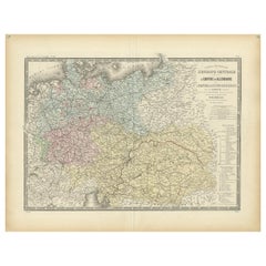
Map of Southeastern Germany & Northern Italy – Antique Engraving, 1858
Antique map titled "Süd-Östliches Deutschland nebst einem Theil des nördlichen Italien," published by Justus Perthes in Gotha in 1855. This finely engraved map offers a detailed view of Southeastern Germany, the Austrian Empire, and Northern Italy in the mid-19th century, just before the unification of Italy and the consolidation of German states.
The map covers southern Bavaria, Tyrol, Styria, Carinthia, Carniola, the Kingdom of Lombardy-Venetia, and regions extending into modern-day Slovenia, Croatia, and northeastern Italy. Cities such as Vienna, Salzburg, Venice, Trieste, Graz, and Milan are clearly marked, alongside a dense network of towns, rivers, roads, and railway lines.
Provincial borders are delicately hand-colored, and a legend at lower right classifies territories based on their political status within the Austrian monarchy. Elevation is indicated through fine hachuring, and both horizontal and vertical elevation profiles frame the map, offering insight into the mountainous Alpine and Dinaric terrain.
This map provides a valuable historical snapshot of Central Europe and the northern Adriatic region under Habsburg rule. It is particularly appealing for collectors interested in 19th-century European cartography, the Austro-Italian relationship, or antique maps of the Alps and Adriatic.
Condition report:
Very good condition. Minor toning to outer margins. Hand-coloring remains vivid. No tears, foxing, or repairs.
Framing suggestions:
Best displayed in a dark or natural wood frame with a soft ivory mat. A thin blue or red inner mat line may highlight the delicate border colors. Perfect for a study, library, or historic-themed interior.
Technique: Copperplate engraving with original hand-coloring
Maker: Justus Perthes, Gotha, 1858
- Dimensions:Height: 14.77 in (37.5 cm)Width: 17.88 in (45.4 cm)Depth: 0.01 in (0.2 mm)
- Materials and Techniques:Paper,Engraved
- Place of Origin:
- Period:
- Date of Manufacture:1858
- Condition:Very good condition. Minor toning to outer margins. Hand-coloring remains vivid. No tears, foxing, or repairs.
- Seller Location:Langweer, NL
- Reference Number:Seller: BG-05552-331stDibs: LU3054346118502
About the Seller
5.0
Recognized Seller
These prestigious sellers are industry leaders and represent the highest echelon for item quality and design.
Platinum Seller
Premium sellers with a 4.7+ rating and 24-hour response times
Established in 2009
1stDibs seller since 2017
2,533 sales on 1stDibs
Typical response time: <1 hour
- ShippingRetrieving quote...Shipping from: Langweer, Netherlands
- Return Policy
Authenticity Guarantee
In the unlikely event there’s an issue with an item’s authenticity, contact us within 1 year for a full refund. DetailsMoney-Back Guarantee
If your item is not as described, is damaged in transit, or does not arrive, contact us within 7 days for a full refund. Details24-Hour Cancellation
You have a 24-hour grace period in which to reconsider your purchase, with no questions asked.Vetted Professional Sellers
Our world-class sellers must adhere to strict standards for service and quality, maintaining the integrity of our listings.Price-Match Guarantee
If you find that a seller listed the same item for a lower price elsewhere, we’ll match it.Trusted Global Delivery
Our best-in-class carrier network provides specialized shipping options worldwide, including custom delivery.More From This Seller
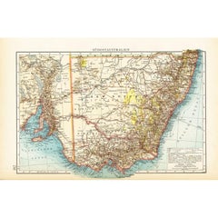
View AllGerman Antique Map of Southeastern Australia, 1904
Located in Langweer, NL
This large antique map is taken from; 'Andrees Allgemeiner Handatlas in 126 Haupt-Und 139 Nebenkarten', Bielefeld; Leipzig: Velhagen & Klasing 1899. Andrees Allgemeiner Handatlas was...
Category
20th Century Maps
Materials
Paper
$70 Sale Price
20% Off
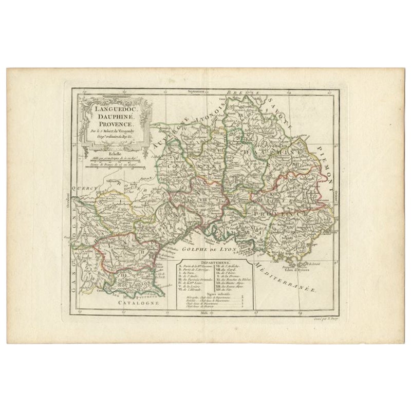
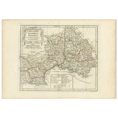
Antique Map of Southeastern France by Vaugondy, c.1790
Located in Langweer, NL
"Antique map titled 'Languedoc, Dauphiné, Province'. Beautiful antique map of Southeastern France with decorative cartouche. Map includes topographical detail as well as a reference ...
Category
Antique 18th Century Maps
Materials
Paper
$150 Sale Price
20% Off
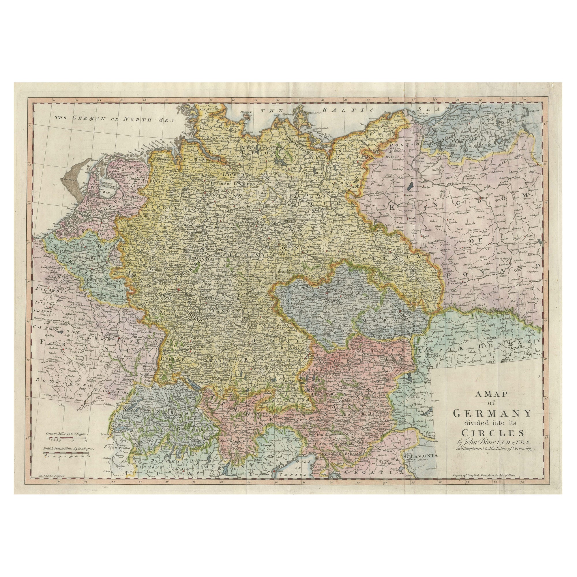
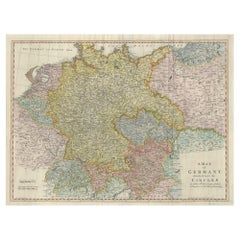
Large Antique Map of the German Empire
Located in Langweer, NL
Antique map titled 'A Map of Germany (..)'. Large antique map of the German Empire, highly detailed. Engraved by T. Kitchin. Published J. Blair, cir...
Category
Antique Late 18th Century Maps
Materials
Paper
$641 Sale Price
20% Off
Antique Map of Southeastern Australia by F. von Stülpnagel, 1850
Located in Langweer, NL
Antique map titled 'Süd-Östlichen Australien'. Map of southeastern Australia with inset maps of southwest Australia and Tasmania compiled by the military cartographer Friedrich von S...
Category
Antique Mid-19th Century Maps
Materials
Paper

$168 Sale Price
35% Off
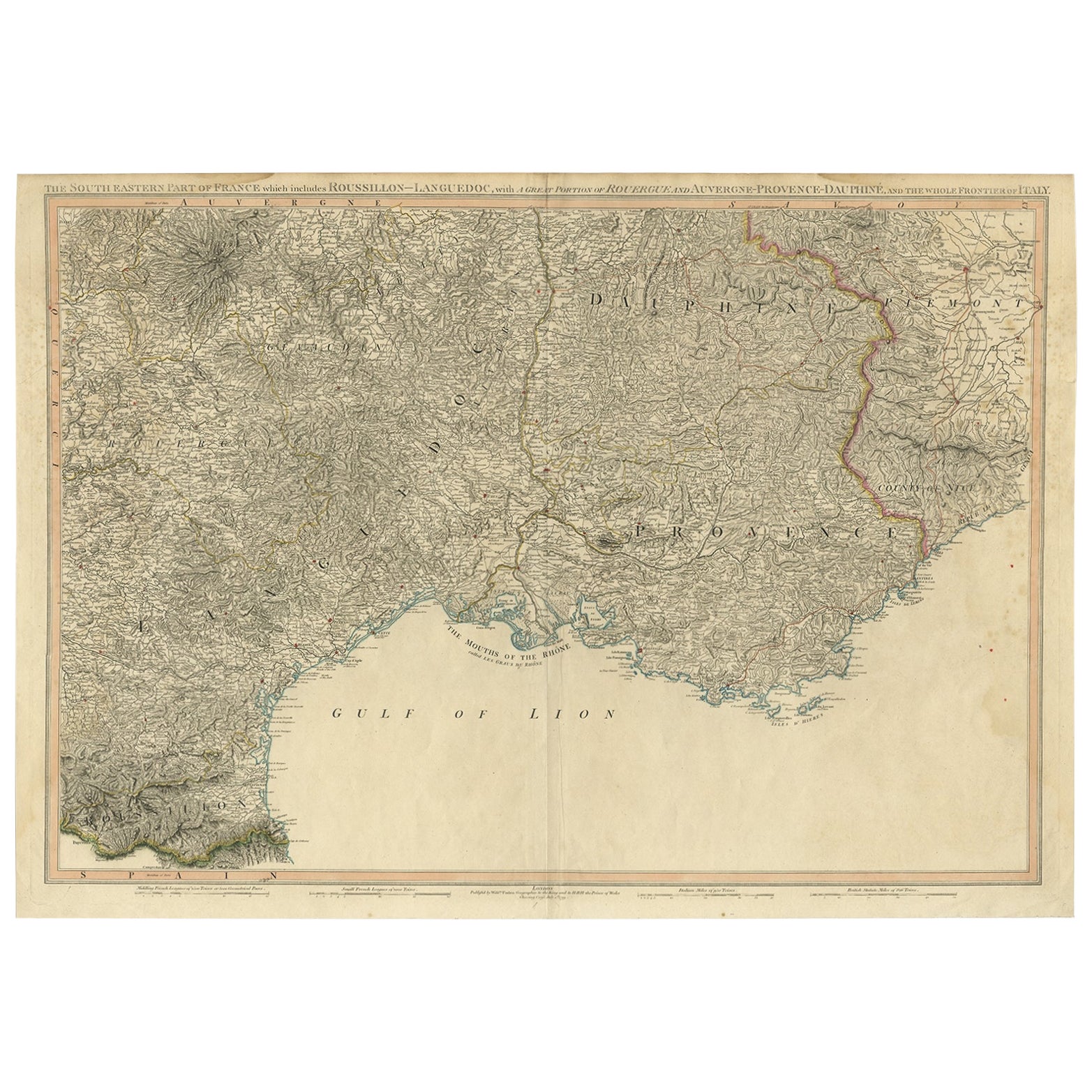
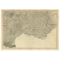
Striking Large Format Antique Map of Southeastern France, 1799
Located in Langweer, NL
Antique map titled 'The South Eastern Part of France which includes Roussillon-Languedoc, with a Great Portion of Rouergue and Auvergne-Provence-Dauphine, and the Whole Frontier of Italy'.
Striking large format map...
Category
Antique 1790s Maps
Materials
Paper
$612 Sale Price
20% Off
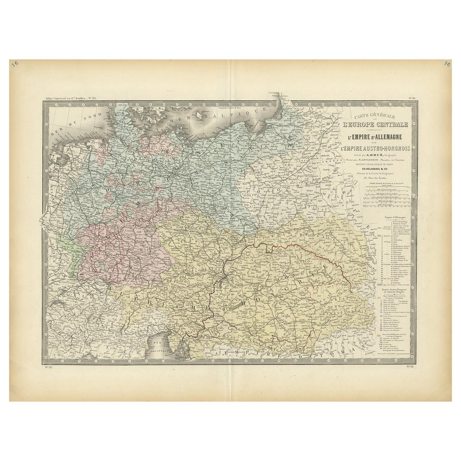
Antique Map of the German Empire by Levasseur, '1875'
Located in Langweer, NL
Antique map titled 'Carte générale de l'Europe Centrale (..)'. Large map of the German Empire. This map originates from 'Atlas de Géographie Moderne Phys...
Category
Antique Late 19th Century Maps
Materials
Paper
$377 Sale Price
20% Off
You May Also Like
17th Century Nicolas Visscher Map of Southeastern Europe
Located in Hamilton, Ontario
A beautiful, highly detailed map of southeastern Europe by Nicolas Visscher. Includes regions of Northern Italy (showing the cities Bologna, Padua, and Venice), Bohemia, Austria (sho...
Category
Antique 17th Century Dutch Maps
Materials
Paper

$1,350 Sale Price
38% Off
1858 Colton's Map of New York, Ric.B011
Located in Norton, MA
An 1858 Colton's map of New York
Ric.b011
Colton’s New York, 1858 - A large original color engraved and very detailed map of the state of New York,...
Category
Antique 19th Century Unknown Maps
Materials
Paper

Southeastern Ireland: A 17th Century Hand Colored Map by Mercator and Hondius
By Gerard Mercator
Located in Alamo, CA
A 17th century copperplate hand-colored map entitled "The Second Table of Ireland, Udrone" by Gerard Mercator and Jodocus Hondius, published in Amsterdam in 1635 in 'Cosmographicall ...
Category
Antique Mid-17th Century Dutch Maps
Materials
Paper

17th Century Hand-Colored Map of Southeastern England by Mercator and Hondius
By Gerard Mercator
Located in Alamo, CA
A 17th century copperplate hand-colored map entitled "The Sixt Table of England" by Gerard Mercator and Jodocus Hondius, published in Amsterdam in 1635 in 'Cosmographicall Descriptio...
Category
Antique Mid-17th Century Dutch Maps
Materials
Paper

Original Antique Map or City Plan of Venice, Italy. Circa 1835
Located in St Annes, Lancashire
Nice map of Venice
Drawn and engraved by J.Dower
Published by Orr & Smith. C.1835
Unframed.
Free shipping
Category
Antique 1830s English Maps
Materials
Paper

Large Original Antique Map of Lombardy and Venice, Italy. John Dower, 1861
Located in St Annes, Lancashire
Great map of Lombardy and Venice
Lithograph engraving by John Dower
Original colour
Published, 1861
Unframed
Good condition / crease to bottom left corner
Free shipping
Category
Antique 1860s English Victorian Maps
Materials
Paper
