Items Similar to Antique Map of Algeria, Tunisia & Tripolitania – Andriveau-Goujon, Paris 1865


Want more images or videos?
Request additional images or videos from the seller
1 of 10
Antique Map of Algeria, Tunisia & Tripolitania – Andriveau-Goujon, Paris 1865
$464.28
£344.80
€390
CA$638.22
A$711.44
CHF 374.46
MX$8,624.67
NOK 4,767.54
SEK 4,432.66
DKK 2,969.10
About the Item
Antique Map of Algeria, Tunisia & Tripolitania – Andriveau-Goujon, Paris 1865
This finely detailed and beautifully colored map was engraved and published in Paris in 1865 by the renowned cartographer E. Andriveau-Goujon. Titled *Carte d’Algérie, de la Tunisie et de la Tripolitaine*, it captures a key region of North Africa during the 19th century, when colonial interests were rapidly expanding and geopolitical dynamics were in flux.
The map focuses on the northern stretch of Africa along the Mediterranean, showing the territories of modern-day Algeria, Tunisia, western Libya (then known as Tripolitaine), and parts of the Sahara. Coastal cities such as Algiers, Tunis, and Tripoli are prominently marked, as are key inland locations such as Constantine, Biskra, and Ghadames.
What sets this map apart is the inclusion of detailed topographic information, including mountain ranges, wadis (riverbeds), and the extensive desert terrain that defines much of the interior. French military routes and administrative boundaries are overlaid across Algeria, which by this time had been colonized by France (since 1830), and whose mapping was of both strategic and political significance.
In the bottom right corner, the map features a well-detailed inset titled Carte d’Ensemble de l’Afrique Septentrionale, providing an overview of the broader Maghreb and Sahel regions, including Morocco, Mauritania, Senegal, and parts of modern-day Mali and Niger. The inset serves as a geographic context for the larger regional interactions in West and North Africa, particularly with regard to trade, French exploration, and colonial expansion.
The map is a compelling document for collectors interested in the history of French colonial cartography, North African geopolitics, and the shifting understanding of Africa’s geography in the mid-19th century.
Condition: Very good condition with original hand color. Light toning at the edges and some minor creases near the centerfold, typical for atlas maps of this age. No tears or repairs.
Framing tips: A dark brown or matte black frame with an ivory or sand-colored mat would best highlight the map’s delicate coloration and historical detail.
Technique: Engraving with original hand coloring
Maker: E. Andriveau-Goujon, Paris, 1865
- Dimensions:Height: 27.64 in (70.2 cm)Width: 20.91 in (53.1 cm)Depth: 0.01 in (0.2 mm)
- Materials and Techniques:Paper,Engraved
- Place of Origin:
- Period:
- Date of Manufacture:1865
- Condition:Condition: Very good condition with original hand color. Light toning at the edges and some minor creases near the centerfold, typical for atlas maps of this age. No tears or repairs.
- Seller Location:Langweer, NL
- Reference Number:Seller: BG-14099-181stDibs: LU3054346188392
About the Seller
5.0
Recognized Seller
These prestigious sellers are industry leaders and represent the highest echelon for item quality and design.
Platinum Seller
Premium sellers with a 4.7+ rating and 24-hour response times
Established in 2009
1stDibs seller since 2017
2,567 sales on 1stDibs
Typical response time: <1 hour
- ShippingRetrieving quote...Shipping from: Langweer, Netherlands
- Return Policy
Authenticity Guarantee
In the unlikely event there’s an issue with an item’s authenticity, contact us within 1 year for a full refund. DetailsMoney-Back Guarantee
If your item is not as described, is damaged in transit, or does not arrive, contact us within 7 days for a full refund. Details24-Hour Cancellation
You have a 24-hour grace period in which to reconsider your purchase, with no questions asked.Vetted Professional Sellers
Our world-class sellers must adhere to strict standards for service and quality, maintaining the integrity of our listings.Price-Match Guarantee
If you find that a seller listed the same item for a lower price elsewhere, we’ll match it.Trusted Global Delivery
Our best-in-class carrier network provides specialized shipping options worldwide, including custom delivery.More From This Seller
View AllAntique Map of Algeria and the French Colonies, 1875
Located in Langweer, NL
Antique map titled 'Algérie et Colonies Francaises'. Large map of Algeria and the French Colonies. This map originates from 'Atlas de Géographie Moderne Physique et Politique' by A. ...
Category
Antique Late 19th Century French Maps
Materials
Paper

$309 Sale Price
35% Off
Antique Map of Algeria, 1880
Located in Langweer, NL
Antique map titled 'Algérie. Old map of Algeria. This map originates from 'Géographie Universelle Atlas-Migeon' by J. Migeon.
Artists and Engravers: Published by J. Migeon. Review...
Category
Antique 19th Century Maps
Materials
Paper
$209 Sale Price
20% Off
Antique Map of the French Colony of Algeria by V. Levasseur, 1854
By Victor Levasseur
Located in Langweer, NL
Antique map titled 'Algérie, Colonie Francaise'. Shows the region divided into the administrative provinces of Oban, Alger, and Constantine. The map proper is surrounded by elaborate...
Category
Antique Mid-19th Century Maps
Materials
Paper

$190 Sale Price
20% Off
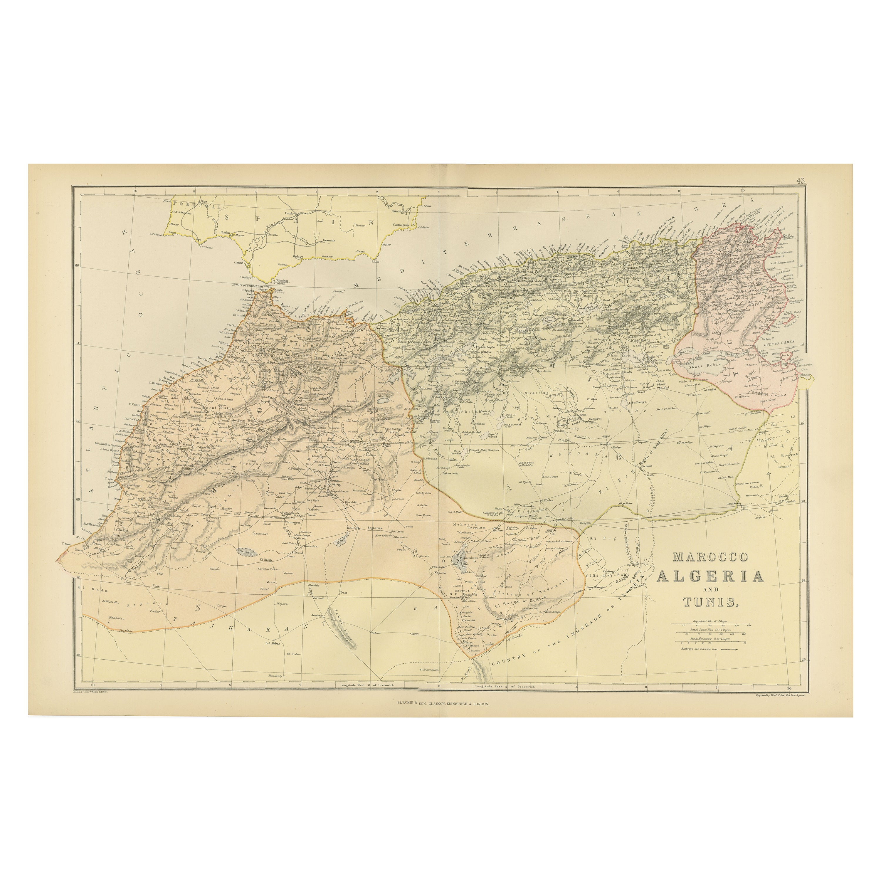
Antique Decorative Coloured Map Marocco, Algeria and Tunis, 1882
Located in Langweer, NL
The maps is from the 1882 atlas by Blackie & Son and offers a detailed view of the North African regions as understood in the late 19th century.
**Map of Morocco, Algeria, and Tun...
Category
Antique 1880s Maps
Materials
Paper

Antique Map of Northern Africa by Perthes, 1848
Located in Langweer, NL
Antique map titled 'Africa Propria (..)'. Old map of North Africa and the region of Babylon originating from 'Orbis Terrarum Antiquus in usum Scholarum'. Artists and Engravers: Publi...
Category
Antique 19th Century Maps
Materials
Paper

$94 Sale Price
20% Off
Antique Map of Northern Africa by Levasseur, '1875'
Located in Langweer, NL
Antique map titled 'Carte de l'Afrique Septentrionale'. Large map of Northern Africa. This map originates from 'Atlas de Géographie Moderne Physique et...
Category
Antique Late 19th Century Maps
Materials
Paper
$380 Sale Price
20% Off
You May Also Like
Africa. North-West Part. Century Atlas antique vintage map
Located in Melbourne, Victoria
'The Century Atlas. Africa. Southern Part'
Original antique map, 1903.
Central fold as issued. Map name and number printed on the reverse corners.
Sheet 40cm by 29.5cm.
Category
Early 20th Century Victorian More Prints
Materials
Lithograph

Large Original Antique Map of Afghanistan. Edward Weller, 1861
Located in St Annes, Lancashire
Great map of Afghanistan
Lithograph engraving by Edward Weller
Original colour
Published, 1861
Unframed
Good condition
Category
Antique 1860s English Victorian Maps
Materials
Paper

Large Original Antique Map of Morocco. Edward Weller, 1861
Located in St Annes, Lancashire
Great map of Morocco
Lithograph engraving by Edward Weller
Original colour
Published, 1861
Unframed
Good condition.
Category
Antique 1860s English Victorian Maps
Materials
Paper

Africa. North-East Part. Century Atlas antique vintage map
Located in Melbourne, Victoria
'The Century Atlas. Africa. North-East Part'
Original antique map, 1903.
Inset map of 'Nile Delta and Suez Canal'.
Central fold as issued. Map name and nu...
Category
Early 20th Century Victorian More Prints
Materials
Lithograph

Map of Eastern Roman Empire -Vintage Offset Print - Early 20th Century
Located in Roma, IT
This map of Eastern Roman Empire is a vintage offset print realized in the early 20th Century.
The state of preservation of the artwork is aged with dif...
Category
Early 20th Century Figurative Prints
Materials
Offset

Original Antique Map of Ancient Greece, Achaia, Corinth, 1786
Located in St Annes, Lancashire
Great map of Ancient Greece. Showing the region of Thessaly, including Mount Olympus
Drawn by J.D. Barbie Du Bocage
Copper plate engraving by P.F Tardieu
Original hand color...
Category
Antique 1780s French Other Maps
Materials
Paper
