Items Similar to Antique Map of Bavaria in Southern Germany and Austria, 1806


Want more images or videos?
Request additional images or videos from the seller
1 of 5
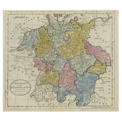
Antique Map of Bavaria in Southern Germany and Austria, 1806
$330.81
$413.5120% Off
£247.96
£309.9520% Off
€280
€35020% Off
CA$454.47
CA$568.0920% Off
A$507.38
A$634.2220% Off
CHF 265.86
CHF 332.3220% Off
MX$6,210.77
MX$7,763.4720% Off
NOK 3,376.39
NOK 4,220.4920% Off
SEK 3,183.51
SEK 3,979.3820% Off
DKK 2,131.46
DKK 2,664.3320% Off
Shipping
Retrieving quote...The 1stDibs Promise:
Authenticity Guarantee,
Money-Back Guarantee,
24-Hour Cancellation
About the Item
Antique map titled 'Cercles de Baviere et d'Autriche.' This map shows Bavaria in southern Germany and Austria. By Robert de Vaugondy, revised and published by Delamarche. Source unknown, to be determined.
Artists and Engravers: Charles Francois Delamarche (1740-1817) founded the important and prolific Paris based Maison Delamarche map publishing firm in the late 18th century. A lawyer by trade Delamarche entered the map business with the acquisition from Jean-Baptiste Fortin of Robert de Vaugondy's map plates and copyrights and later addes many plates from other sources as well. Charles Delamarche eventually passed control of the firm to his son Felix Delamarche (18th C. - 1st half 19th C.) and geographer Charles Dien (1809-1870). It was later passed on to Alexandre Delamarche, who revised and reissued several Delamarche publications in the mid-19th century. The firm continued to publish maps and globes until the middle part of the 19th century.
Condition: Good, given age. Original middle fold as issued. General age-related toning and/or occasional minor defects from handling. Please study image carefully.
Date: 1806
Overall size: 33.5 x 28.3 cm.
Image size: 24 x 28.2 cm.
- Dimensions:Height: 11.15 in (28.3 cm)Width: 13.19 in (33.5 cm)Depth: 0 in (0.01 mm)
- Materials and Techniques:
- Period:
- Date of Manufacture:1806
- Condition:
- Seller Location:Langweer, NL
- Reference Number:Seller: PCT-615971stDibs: LU3054326145562
About the Seller
5.0
Recognized Seller
These prestigious sellers are industry leaders and represent the highest echelon for item quality and design.
Platinum Seller
Premium sellers with a 4.7+ rating and 24-hour response times
Established in 2009
1stDibs seller since 2017
2,511 sales on 1stDibs
Typical response time: <1 hour
- ShippingRetrieving quote...Shipping from: Langweer, Netherlands
- Return Policy
Authenticity Guarantee
In the unlikely event there’s an issue with an item’s authenticity, contact us within 1 year for a full refund. DetailsMoney-Back Guarantee
If your item is not as described, is damaged in transit, or does not arrive, contact us within 7 days for a full refund. Details24-Hour Cancellation
You have a 24-hour grace period in which to reconsider your purchase, with no questions asked.Vetted Professional Sellers
Our world-class sellers must adhere to strict standards for service and quality, maintaining the integrity of our listings.Price-Match Guarantee
If you find that a seller listed the same item for a lower price elsewhere, we’ll match it.Trusted Global Delivery
Our best-in-class carrier network provides specialized shipping options worldwide, including custom delivery.More From This Seller
View AllAntique Map of Bavaria and Salzburg by Cary, 1811
By John Cary
Located in Langweer, NL
Antique map titled 'A New Map of the Circle of Bavaria'. Antique map of Bavaria and Salzburg, Germany. Covers the Duchy of Bavaria and the mountainous A...
Category
Antique Early 19th Century Maps
Materials
Paper

$236 Sale Price
20% Off
Antique Map of Franconia, a region of Germany, '1811'
By John Cary
Located in Langweer, NL
Antique map titled 'A New Map of the Circle of Franconia'. Detailed map of Franconia in Northwestern Germany. Covers from Upper Saxony south to Swabia, west to the Lower Rhine and we...
Category
Antique Early 19th Century Maps
Materials
Paper

$236 Sale Price
20% Off
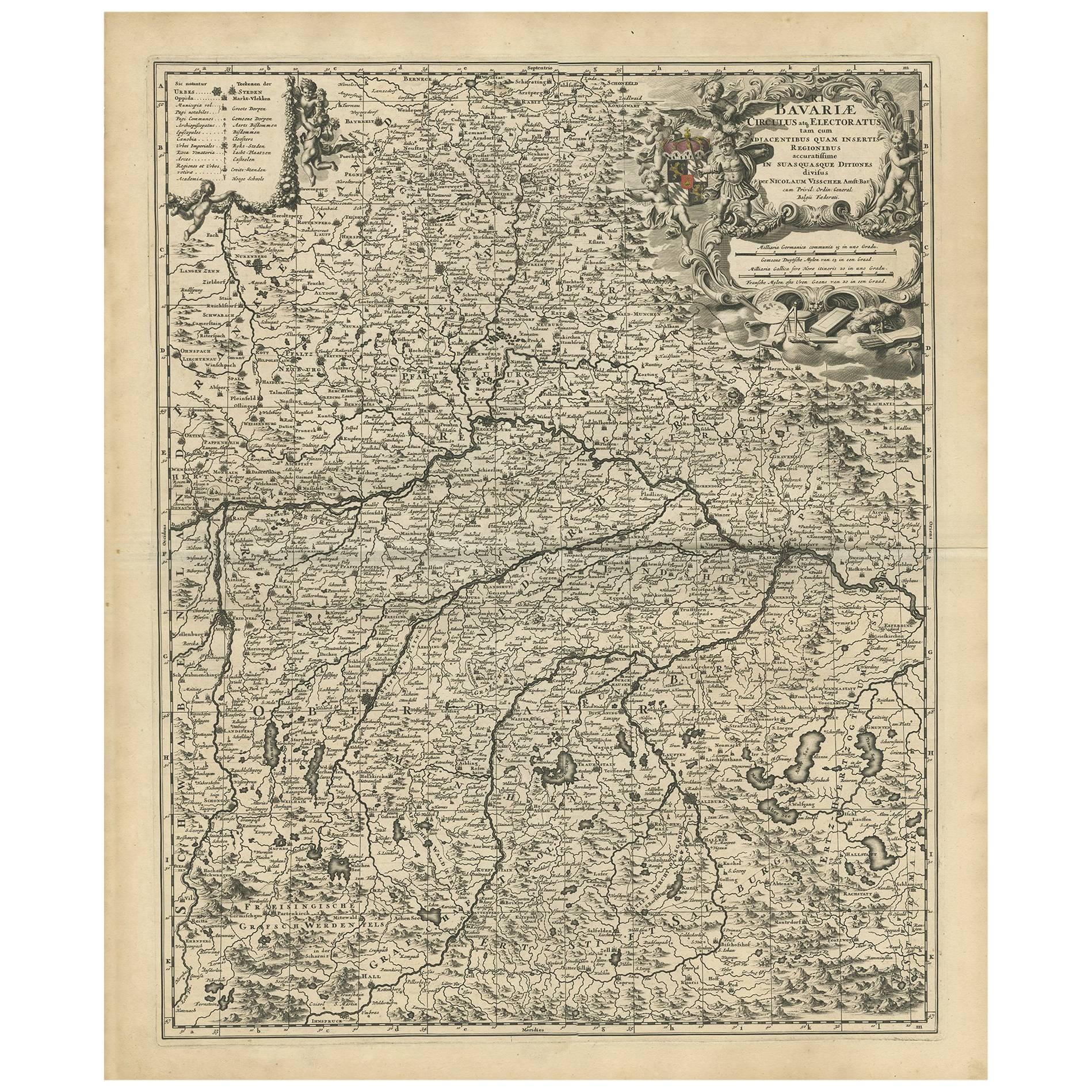
Antique Map of Bavaria with many details, Germany
Located in Langweer, NL
Antique map titled 'Bavariae Circulus atq Electoratus tam cum Adiacentibus quam insertis Regionibus (..)'. Dutch map of Bavaria, showing the many cities, towns, and other features of...
Category
Antique Late 17th Century Maps
Materials
Paper
$623 Sale Price
20% Off
Antique Map of Lower Saxony by Clouet, 1787
Located in Langweer, NL
Antique map titled 'Basse Saxe'. Antique map of Lower Saxony, Germany. Originates from 'Geographie moderne avec une introduction' by J.B.L. Clouet.
Category
Antique Late 18th Century Maps
Materials
Paper

$283 Sale Price
20% Off
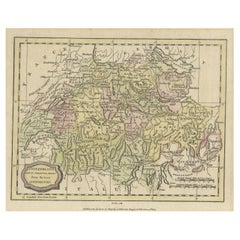
Small Original Antique Map of Switzerland and Surroundings, 1807
Located in Langweer, NL
Antique map titled 'Switzerland with its subjects & allies from the best authorities'.
Small map of Switzerland and surroundings. Originates from 'A general view of the world' by...
Category
Antique Early 1800s Maps
Materials
Paper
$122 Sale Price
20% Off
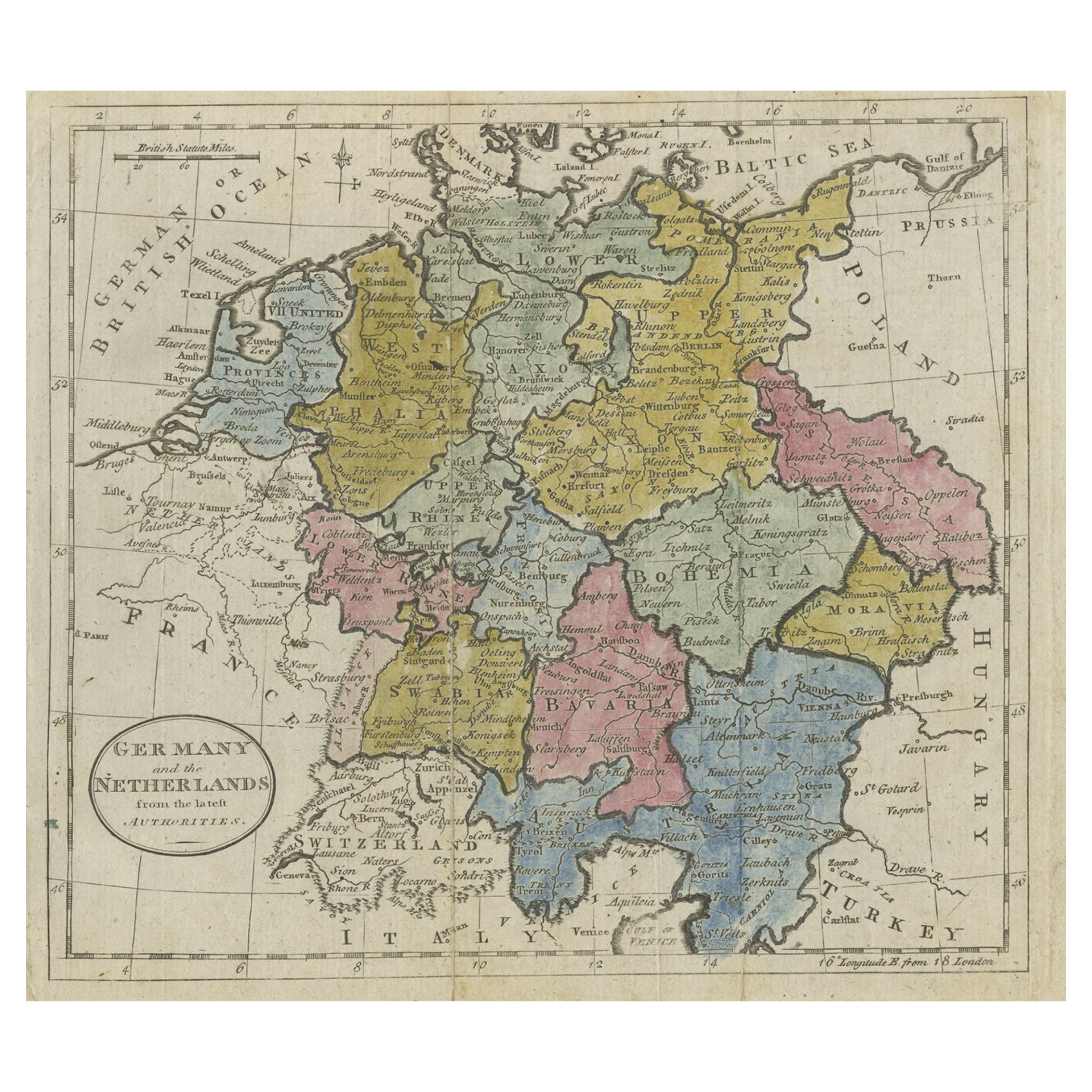
Antique Map of Germany, the Netherlands, Bohemia, Bavaria and Switzerland, 1785
Located in Langweer, NL
Antique map titled 'Germany and the Netherlands from the latest authorities'. Depicts Germany, the Netherlands and the surrounding region including Bohemia, Bavaria, and Switzerland....
Category
Antique 18th Century Maps
Materials
Paper
$132 Sale Price
20% Off
You May Also Like
1839 Map of Karte Des "Russischen Reiches in Europa Und Asien" Ric.R0013
Located in Norton, MA
1839 map of Karte Des
"Russischen Reiches in Europa and Asien"
Ric.r013
Map of the European and Asian parts of Russian Empire. Karte der Russischen Reiches in Europa und Asien...
Category
Antique 19th Century Unknown Maps
Materials
Paper

Original Antique Map of Switzerland, Engraved By Barlow, Dated 1807
Located in St Annes, Lancashire
Great map of Switzerland
Copper-plate engraving by Barlow
Published by Brightly & Kinnersly, Bungay, Suffolk.
Dated 1807
Unframed.
Category
Antique Early 1800s English Maps
Materials
Paper

18th Century Hand-Colored Homann Map of Germany, Including Frankfurt and Berlin
By Johann Baptist Homann
Located in Alamo, CA
An 18th century hand-colored map entitled "Tabula Marchionatus Brandenburgici et Ducatus Pomeraniae quae sunt Pars Septentrionalis Circuli Saxoniae Superioris" by Johann Baptist Homa...
Category
Antique Early 18th Century German Maps
Materials
Paper

17th Century Hand-Colored Map of a Region in West Germany by Janssonius
By Johannes Janssonius
Located in Alamo, CA
This attractive highly detailed 17th century original hand-colored map is entitled "Archiepiscopatus Maghdeburgensis et Anhaltinus Ducatus cum terris adjacentibus". It was published ...
Category
Antique Mid-17th Century Dutch Maps
Materials
Paper

Hand Colored 18th Century Homann Map of Austria Including Vienna and the Danube
By Johann Baptist Homann
Located in Alamo, CA
"Archiducatus Austriae inferioris" is a hand colored map of Austria created by Johann Baptist Homann (1663-1724) and published in Nuremberg, Germany in 1728 shortly after his death. ...
Category
Antique Early 18th Century German Maps
Materials
Paper

Original Antique Map of Hungary, Arrowsmith, 1820
Located in St Annes, Lancashire
Great map of Hungary
Drawn under the direction of Arrowsmith.
Copper-plate engraving.
Published by Longman, Hurst, Rees, Orme and Brown, 1820
Unframed.
Category
Antique 1820s English Maps
Materials
Paper

More Ways To Browse
Bavaria Antique
Bavaria Plate
Joan Blaeu
Antique Nautical Maps
Antique Portuguese Plates
New Zealand Map
Antique Railroad Collectibles
Blaeu World Map
Roman Empire Map
Antique Map Of Middle East
Caribbean Map
Antique Map Of Egypt
Antique Map Ortelius
Antique Farm Antiques Collectibles
Antique Galleon
Biblical Maps
Medieval Capital
Civil War Map