Items Similar to Antique Map of the Caroline Islands – Early Exploration of the Pacific, c.1760


Want more images or videos?
Request additional images or videos from the seller
1 of 11
Antique Map of the Caroline Islands – Early Exploration of the Pacific, c.1760
$464.78
£344.20
€390
CA$640.33
A$711.93
CHF 374.88
MX$8,637.91
NOK 4,746.12
SEK 4,436.47
DKK 2,968.61
About the Item
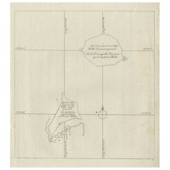
Map of the Caroline Islands – “Nouvelle Description des Isles Carolines”, c.1760
This 18th-century copperplate map, titled Nouvelle Description des Isles Carolines, charts the Caroline Islands in the western Pacific Ocean. It is credited to the Jesuit missionary Father Pierre Daubenton (R.P. Daubenton, de la Compagnie de Jésus), who served as confessor to the King of Spain. The chart provides a detailed view of the island groups between the Philippines and the Mariana Islands to the west and the Marshall Islands to the east.
The map spans from the eastern edge of the Philippines, marked with “Pointe de Guingam,” to widely scattered island chains including Ulithi, Yap, and Palau to the west, and islands such as Lamurrec, Fais, and Falalop toward the center. Further east, the chart identifies individual islands and reefs with French-transliterated names, along with navigational hazards such as the Banc de Falrey. Radiating rhumb lines suggest maritime routes and navigational bearings across the archipelago.
The inclusion of numerous small atolls, shoals, and islets reflects both Spanish exploration in the Pacific and Jesuit involvement in the dissemination of geographical knowledge during the Enlightenment. The Caroline Islands, under nominal Spanish control at the time, were important waypoints in the trans-Pacific Manila galleon trade linking the Philippines to New Spain (Mexico).
Marked “P. 408” in the upper right, the plate likely comes from a French encyclopedic or voyage collection documenting global geography. The style of the engraving, with clean coastal outlines and minimal inland detail, is characteristic of nautical charts designed for navigation rather than political mapping.
Condition: Good for age, with central folds as issued. Minor toning and light spotting near the fold. Strong plate impression with fine island detail.
Framing tips: A black or dark walnut frame with a cream or off-white mount will emphasize the crisp engraving and navigational features. For a thematic display, it pairs well with other 18th-century Pacific exploration charts.
Technique: Copperplate engraving
Maker: Father Pierre Daubenton (source), French school, c.1760
- Dimensions:Height: 9.45 in (24 cm)Width: 15.36 in (39 cm)Depth: 0.01 in (0.2 mm)
- Materials and Techniques:Paper,Engraved
- Place of Origin:
- Period:
- Date of Manufacture:circa 1760
- Condition:Condition: Good for age, with central folds as issued. Minor toning and light spotting near the fold. Strong plate impression with fine island detail.
- Seller Location:Langweer, NL
- Reference Number:Seller: BG-14078-341stDibs: LU3054346218402
About the Seller
5.0
Recognized Seller
These prestigious sellers are industry leaders and represent the highest echelon for item quality and design.
Platinum Seller
Premium sellers with a 4.7+ rating and 24-hour response times
Established in 2009
1stDibs seller since 2017
2,569 sales on 1stDibs
Typical response time: <1 hour
- ShippingRetrieving quote...Shipping from: Langweer, Netherlands
- Return Policy
Authenticity Guarantee
In the unlikely event there’s an issue with an item’s authenticity, contact us within 1 year for a full refund. DetailsMoney-Back Guarantee
If your item is not as described, is damaged in transit, or does not arrive, contact us within 7 days for a full refund. Details24-Hour Cancellation
You have a 24-hour grace period in which to reconsider your purchase, with no questions asked.Vetted Professional Sellers
Our world-class sellers must adhere to strict standards for service and quality, maintaining the integrity of our listings.Price-Match Guarantee
If you find that a seller listed the same item for a lower price elsewhere, we’ll match it.Trusted Global Delivery
Our best-in-class carrier network provides specialized shipping options worldwide, including custom delivery.More From This Seller
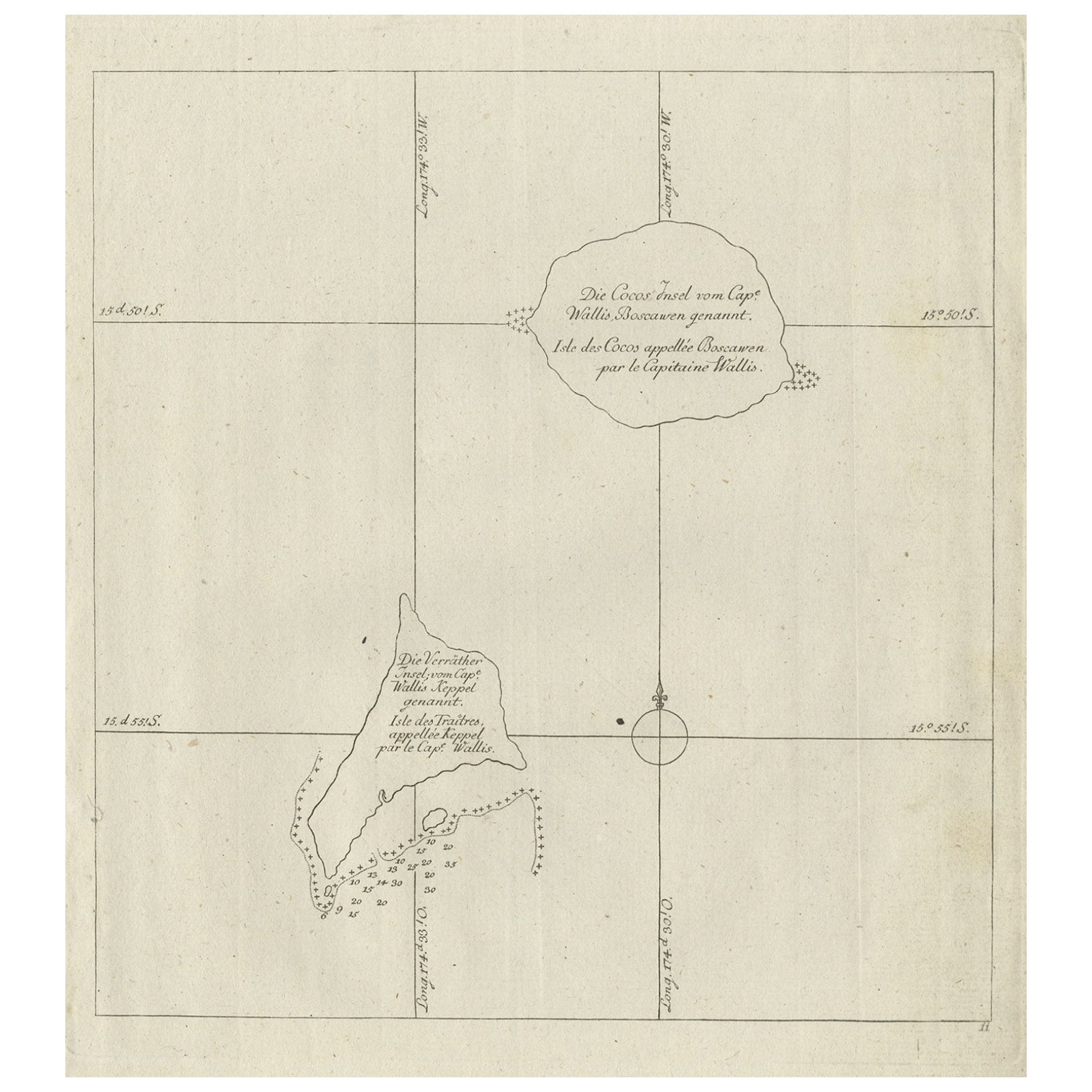
View AllAntique Map of the Cocos or Keeling Islands, 1778
Located in Langweer, NL
Antique map titled 'Die Cocos Insel vom Capt. Wallis Bosawren. Die Verrather Islel von Capt. Wallis Keppel Genannt'. Also with French subtitles. Old map of the Cocos or Keeling Islan...
Category
Antique 18th Century Maps
Materials
Paper
$276 Sale Price
20% Off
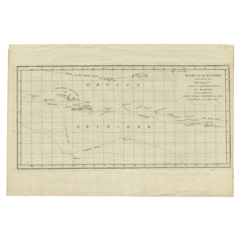
Antique Map of French Polynesia by Cook Showing His Route, 1803
Located in Langweer, NL
Antique map Tahiti titled 'Kaart van de Eilanden in den omtrek van Otahiti (..)'. Antique map of French Polynesia with the tracks around the island of Tahiti by Captain Byron, Wallis...
Category
Antique 19th Century Maps
Materials
Paper
$452 Sale Price
20% Off
Antique Map of New Guinea and New Britain by P. Carteret, circa 1773
Located in Langweer, NL
Antique Map: A Chart of Captain Carteret's Discoveries at New Britain (1769)
This rare and historically significant 18th-century map, titled *A Chart of Captn Carteret's Discoveries at New Britain,* offers a fascinating glimpse into early European explorations of the Pacific. Published in 1769, the map meticulously charts Captain Philip Carteret's 1767 voyage through New Guinea and the islands of New Britain and New Ireland, showcasing his contributions to the understanding of the Bismarck Archipelago. Adding to its significance, the map traces the paths of earlier explorer William Dampier...
Category
Antique Late 18th Century Maps
Materials
Paper

$524 Sale Price
20% Off
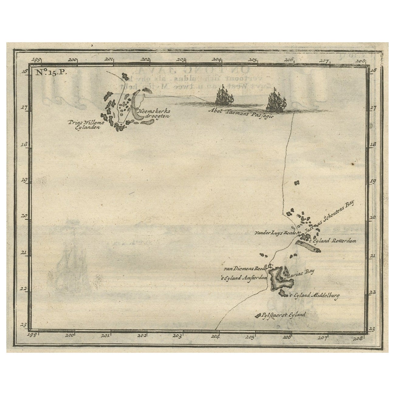
Antique Map of the Friendly Islands by Cook, 1803
Located in Langweer, NL
Antique map Friendly Islands titled 'Kaart van de Vrienden Eilanden'. Antique map of the Friendly Islands depicting Rotterdam or Anamocka, Middelburg or Eaoowe and Amsterdam or Tonga...
Category
Antique 19th Century Maps
Materials
Paper

$204 Sale Price
20% Off
Antique Map of the Banda Islands and the Route of Abel Tasman, Indonesia, 1726
Located in Langweer, NL
Antique print Indonesia with an image on each side. The first image depicts Ontong Java, one of the largest atolls on earth. On verso: antique map of the Banda Islands. With the rout...
Category
Antique 1720s Maps
Materials
Paper
$402 Sale Price
24% Off
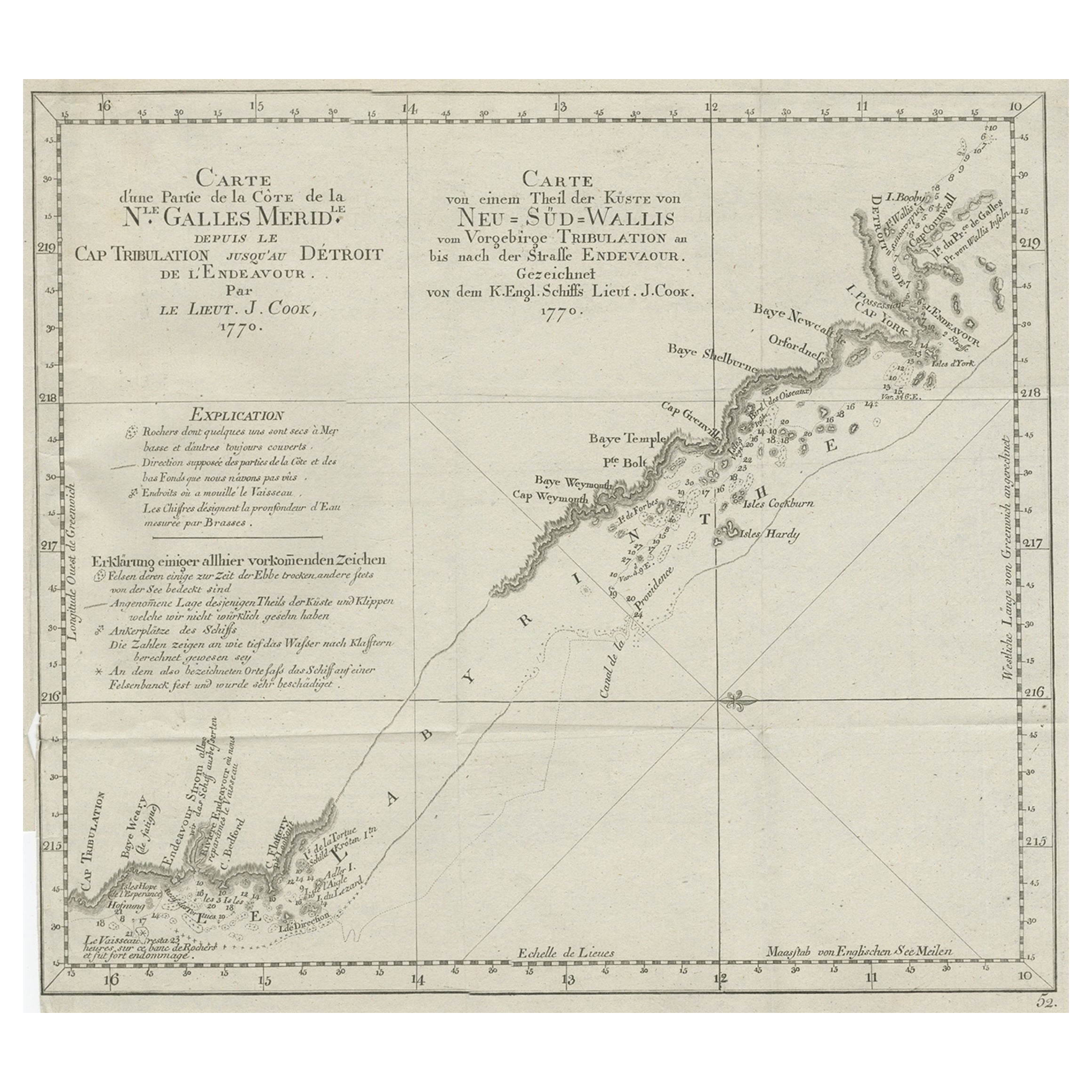
Old Chart of the North-Eastern Coast of Australia Discovered by Cook, 1774
Located in Langweer, NL
Antique print titled Carte d'une Partie de la Cote de la N.le Galles Merid etc.
An interesting chart of the north-eastern coast of Australia discovered by Cook in 1770, showing th...
Category
Antique 1770s Maps
Materials
Paper
$724 Sale Price
20% Off
You May Also Like
Ancient Map of Oceania - Original Etching - 19th century
Located in Roma, IT
This Map of Oceania is an etching realized in the 19th century.
The state of preservation of the artwork is good. At the top of the paper, the inscription “Longitudine del Meridiano...
Category
19th Century More Prints
Materials
Etching

Original Antique Map of US Possessions In The Pacific Ocean, C.1900
Located in St Annes, Lancashire
Fabulous map of US possessions in the Pacific Ocean
Original color.
Engraved and printed by the George F. Cram Company, Indianapolis.
Published, C.1900.
Unframed.
Free shipping.
Category
Antique 1890s American Maps
Materials
Paper

Large Original Antique Map of The Pacific Ocean, Fullarton, C.1870
Located in St Annes, Lancashire
Great map of The Pacific Ocean
From the celebrated Royal Illustrated Atlas
Lithograph by Swanston. Original color.
Published by Fullarton,...
Category
Antique 1870s Scottish Maps
Materials
Paper

Large Original Antique Map of The Leeward Islands. 1894
Located in St Annes, Lancashire
Superb Antique map of The Leeward Islands
Published Edward Stanford, Charing Cross, London 1894
Original colour
Good condition
Unframed.
Free shipping
Category
Antique 1890s English Maps
Materials
Paper

Original Antique Map of Australia by Dower, circa 1835
Located in St Annes, Lancashire
Nice map of Australia
Drawn and engraved by J.Dower
Published by Orr & Smith. C.1835
Unframed.
Free shipping
Category
Antique 1830s English Maps
Materials
Paper

Large Original Vintage Map of The Pacific Islands Including Hawaii
Located in St Annes, Lancashire
Great map of The Pacific Islands
Unframed
Original color
By John Bartholomew and Co. Edinburgh Geographical Institute
Published, circa 1...
Category
Vintage 1920s British Maps
Materials
Paper
