Items Similar to Old Chart of the North-Eastern Coast of Australia Discovered by Cook, 1774
Want more images or videos?
Request additional images or videos from the seller
1 of 6
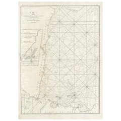
Old Chart of the North-Eastern Coast of Australia Discovered by Cook, 1774
About the Item
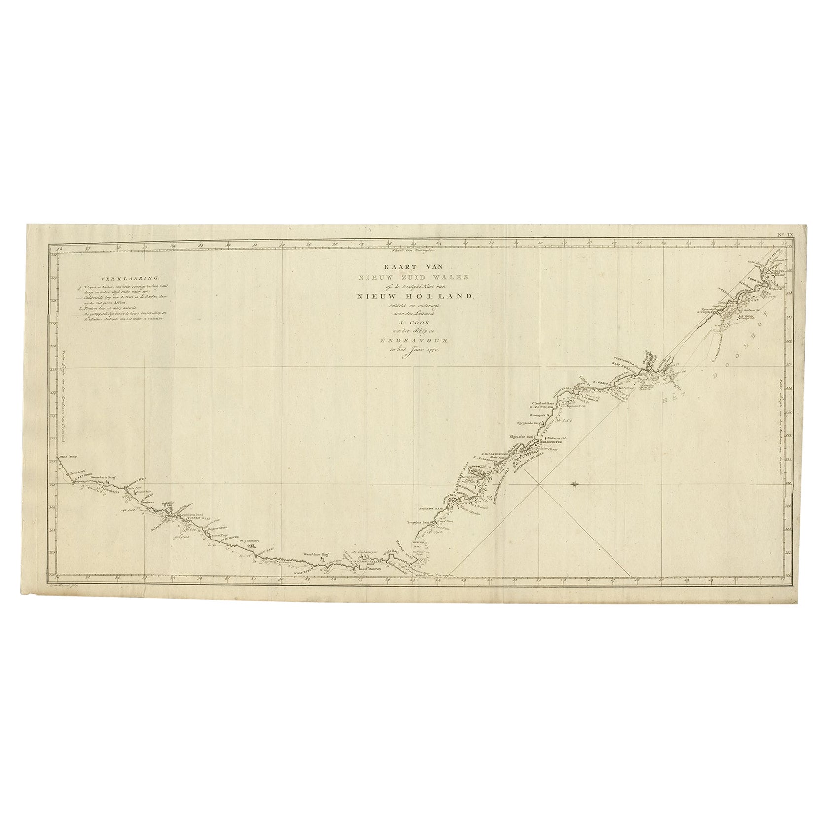
Antique print titled Carte d'une Partie de la Cote de la N.le Galles Merid etc.
An interesting chart of the north-eastern coast of Australia discovered by Cook in 1770, showing the Endeavour River and the Endeavour Strait, so named by Cook after his ship was careened and repaired on the banks of the river following grounding on a coral reef offshore, the site of present day Cooktown.
Originates from 'Geschichte der See-Reisen und Entdeckungen im Süd-Meer welche auf Befehl Sr. Großbrittanischen Majestät unternommen, und von Commodore Byron, Capitain Wallis, Capitain Carteret und Capitain Coockim Dolphin, der Swallow, und dem Endeavour nach einander ausgeführt worden sind..
Artists and Engravers: Published by Haude & Spener, Berlin.
- Dimensions:Height: 13.19 in (33.5 cm)Width: 15.95 in (40.5 cm)Depth: 0 in (0.02 mm)
- Materials and Techniques:
- Period:1770-1779
- Date of Manufacture:1774
- Condition:Wear consistent with age and use. Condition: Good, general age-related toning. Defect lower left margin, slightly affecting image. Please study image carefully.
- Seller Location:Langweer, NL
- Reference Number:
About the Seller
5.0
Platinum Seller
These expertly vetted sellers are 1stDibs' most experienced sellers and are rated highest by our customers.
Established in 2009
1stDibs seller since 2017
1,929 sales on 1stDibs
Typical response time: <1 hour
- ShippingRetrieving quote...Ships From: Langweer, Netherlands
- Return PolicyA return for this item may be initiated within 14 days of delivery.
More From This SellerView All
- Old Map of Cook's Discovery and Charting of the East Coast of Australia, 1803Located in Langweer, NLAntique map titled 'Kaart van Nieuw Zuid Wales of de Oostlyke Kust van Nieuw Holland ontdekt en onderzogt door den Luitenant J. Cook met het Schip de Endeavour in het Jaar 1770'. ...Category
Antique Early 1800s Maps
MaterialsPaper
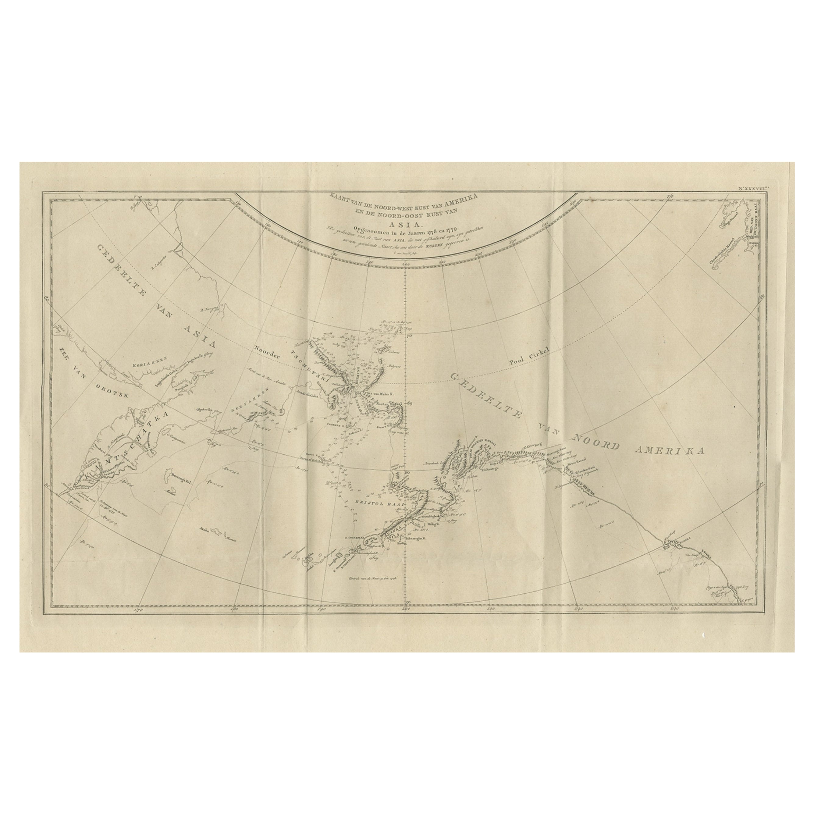
- Old Map Showing the Tracks of Cook Between North America and Asia's Coast, 1803Located in Langweer, NLDescription: Antique map titled 'Kaart van de Noord-West kust van Amerika en de Noord-Oost kust van Asia'. Antique chart depicting America's northwest coast and Asia's northeast ...Category
Antique Early 1800s Maps
MaterialsPaper
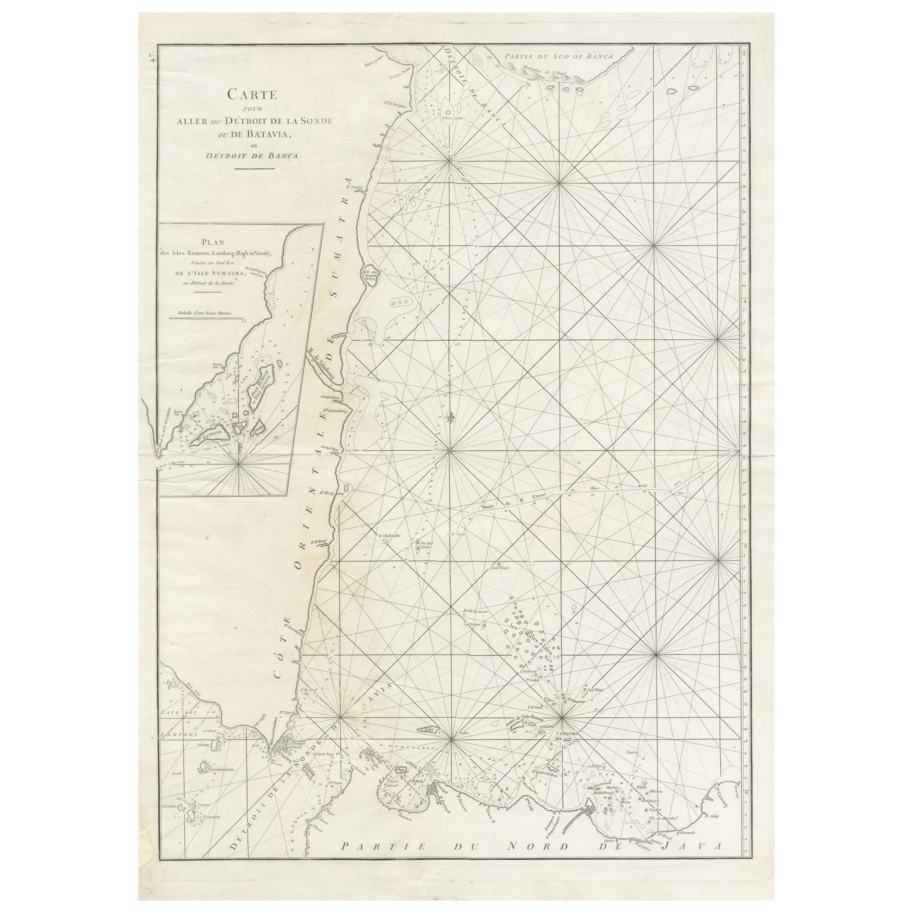
- Large Antique Sea Chart of the South-Eastern Coast of Sumatra, IndonesiaLocated in Langweer, NLAntique map titled 'Carte pour aller du Détroit de la Sonde ou de Batavia, au Détroit de Banca'. This uncommon sea chart shows northern Java and eastern Sumatra along with an inset of the small islands in the Detroit Sound. The handsome chart provides detailed navigational information, including the route of Julien Crozet in April 1772, who led a French expedition to the South Pacific after the voyage's commander, Marion De Fresne, and 26 crew members were killed (and allegedly eaten) by a Maori tribe in the Bay of Islands off the coast of New Zealand. With title upper left corner and small inset map of the small isles nearby the south-eastern coast of Sumatra. J. B. d'Apres de Mannevillette, from his atlas "Neptune orientale". French sailor...Category
Antique Late 18th Century Maps
MaterialsPaper
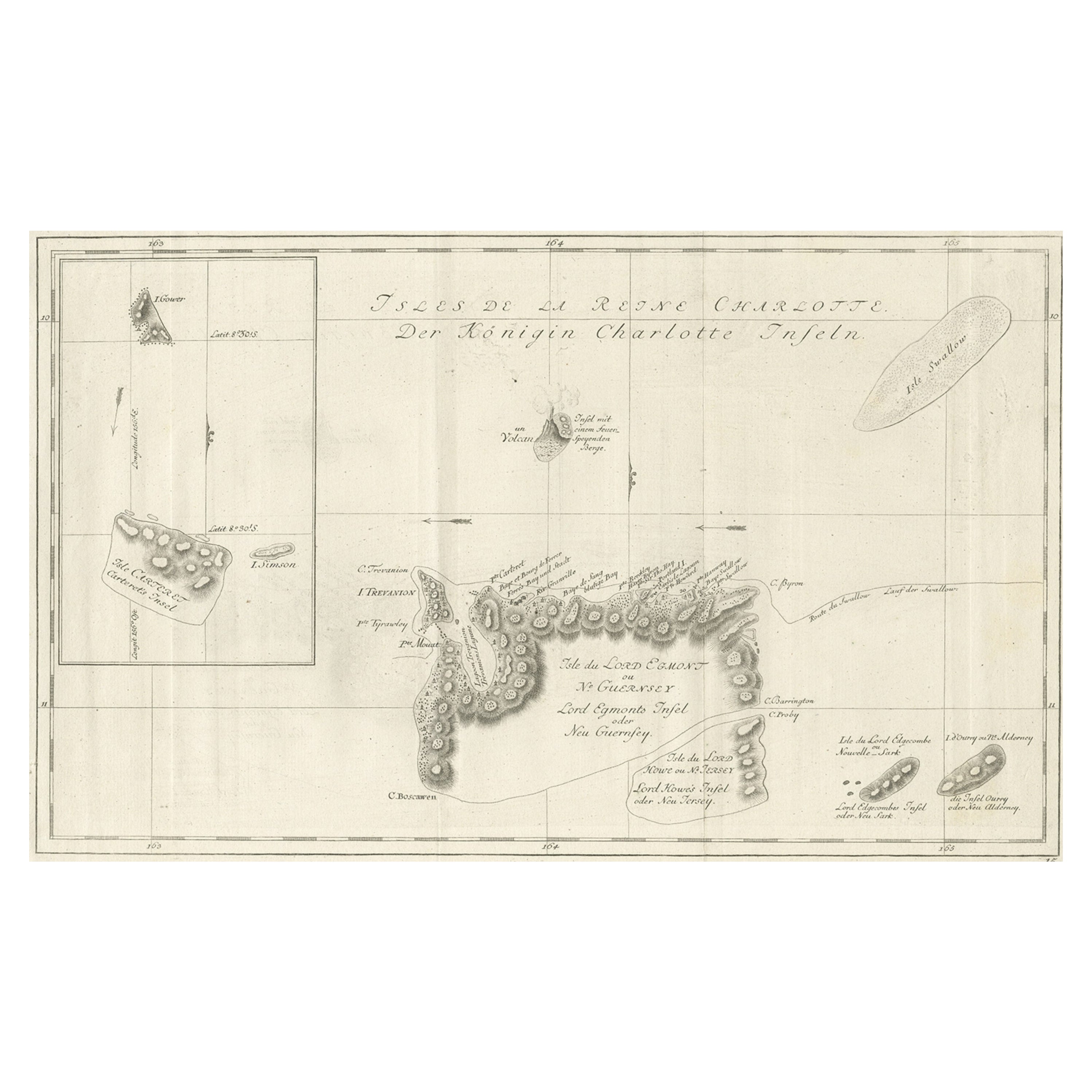
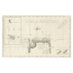
- Original Antique Chart of the Santa Cruz Islands, 1774Located in Langweer, NLAntique print titled 'Isles de la Reine Charlotte (..)'. A detailed chart of the Santa Cruz islands, to the north of the New Hebrides, with Carte...Category
Antique 1770s Maps
MaterialsPaper
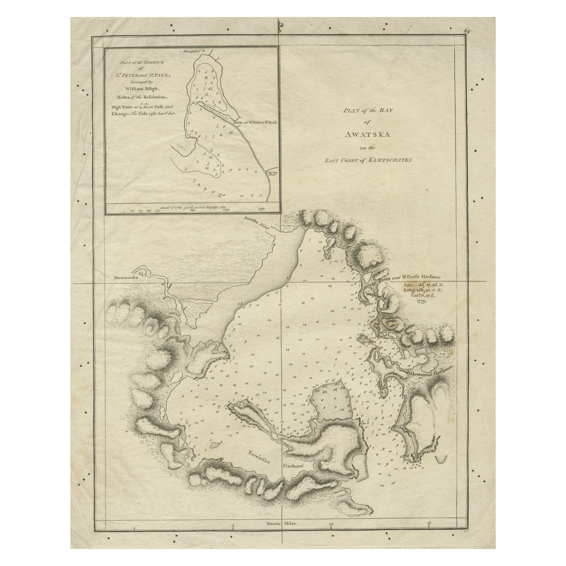
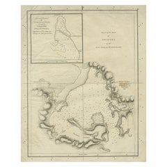
- Old Map of Awatska Bay on the Coast of Kamchatka Peninsula, Russia by Cook, 1784Located in Langweer, NLAntique map Awatska titled 'Plan of the Bay of Awatska (..)'. Antique map of Awatska Bay on the east coast of the Russian peninsula of Kamtschatka. Inset plan of St. Peter’s and St. ...Category
Antique 18th Century Maps
MaterialsPaper
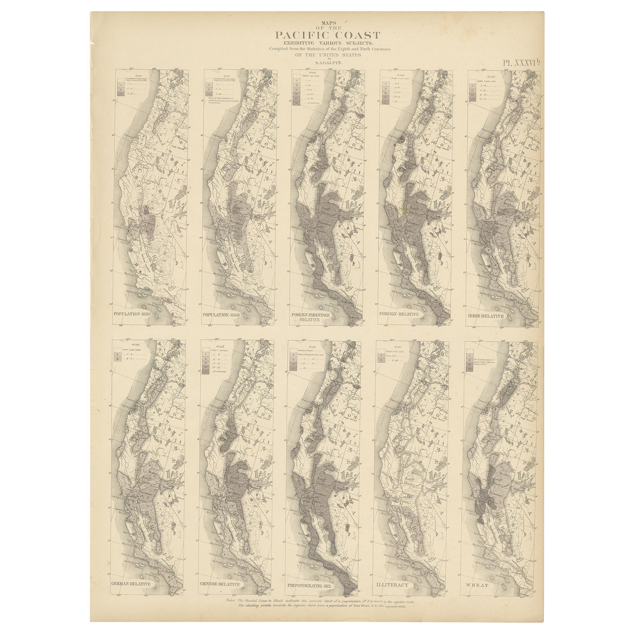
- Antique Chart of the Pacific Coast '1874'Located in Langweer, NLAntique chart titled 'Maps of the Pacific Coast exhibiting various subjects. Compiled from the statistics of the eight and ninth census of the United Sta...Category
Antique Late 19th Century Maps
MaterialsPaper

You May Also Like
- Chart of the East Coast of EnglandLocated in Norwell, MAChart of the East Coast of England, from Dungeness to Flamborough, including the entrances to the Thames River. Drawn by hydrographer J.W. Norie in 1841. Includes Kent, Essex and Suf...Category
Antique 1840s English Nautical Objects
MaterialsPaper
- Old Nautical Print Depicting the Bombardment of Cadiz by the French Navy 1823Located in Milan, ITPrint by engraving on copper plate of the first half of the 19th century, depicting the bombardment of Cadiz by the French Navy, 23 September 1823. The print is signed peint par Crep...Category
Antique 1830s French Nautical Objects
MaterialsPaper
- New Map of North America from the Latest Discoveries, 1763Located in Philadelphia, PAA fine antique 18th century map of the North American seaboard. Entitled "A New Map of North America from the Latest Discoveries 1763". By the Cartographer/Engraver - John Spil...Category
Antique Mid-18th Century English Georgian Maps
MaterialsPaper
- Antique Anatomical Wall Chart Depicting the Human SkeletonLocated in Berghuelen, DEA rare 19th century anatomical wall chart depicting the human skeleton. On the sides On the sides are detailed description in German language. The wall...Category
Early 20th Century German Victorian Prints
MaterialsPaper
- Captain Cook's Exploration of Tahiti 18th C. Hand-Colored Map by BellinBy Jacques-Nicolas BellinLocated in Alamo, CAThis beautiful 18th century hand-colored copper plate engraved map is entitled "Carte de l'Isle de Taiti, par le Lieutenant J. Cook" was created by Jacques Nicolas Bellin and publish...Category
Antique Mid-18th Century French Maps
MaterialsPaper
- Anatomical Wall Chart Depicting the Human Lymphatic and Blood VesselsLocated in Berghuelen, DEA rare 19-carat anatomical wall chart depicting the human lymphatic and blood vessels. On the sides with detailed description in German language. Print...Category
Early 20th Century German Victorian Prints
MaterialsPaper


Recently Viewed
View AllMore Ways To Browse
Australian Antique Furniture
Antique Furniture In Australia
Australia Antique Furniture
Antique Sr
Antique Swallow
A La Carte
Collectible Banks Antique
Antique Collectables Australia
Antique Maps Australia
Antique Map Australia
Australia Antique Map
Antique Maps Of Australia
Antique Map Of Australia
Antique Australia Map
Antique Australian Map
Antique Australian Maps
Le Sud
De La Sud