Items Similar to Large Antique Sea Chart of the South-Eastern Coast of Sumatra, Indonesia


Want more images or videos?
Request additional images or videos from the seller
1 of 6
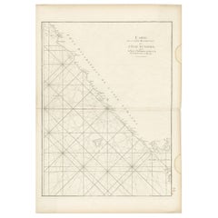
Large Antique Sea Chart of the South-Eastern Coast of Sumatra, Indonesia
About the Item
Antique map titled 'Carte pour aller du Détroit de la Sonde ou de Batavia, au Détroit de Banca'. This uncommon sea chart shows northern Java and eastern Sumatra along with an inset of the small islands in the Detroit Sound. The handsome chart provides detailed navigational information, including the route of Julien Crozet in April 1772, who led a French expedition to the South Pacific after the voyage's commander, Marion De Fresne, and 26 crew members were killed (and allegedly eaten) by a Maori tribe in the Bay of Islands off the coast of New Zealand. With title upper left corner and small inset map of the small isles nearby the south-eastern coast of Sumatra.
J. B. d'Apres de Mannevillette, from his atlas "Neptune orientale". French sailor and hydrographer, D' Après de Mannevillette (1707-1780) used new instruments to correct the latitudes measured by previous explorers. His atlas Le Neptune Oriental, first published in 1745, was considered a major achievement and an indispensable resource for navigators.
- Dimensions:Height: 30.2 in (76.7 cm)Width: 20.87 in (53 cm)Depth: 0.02 in (0.5 mm)
- Materials and Techniques:
- Period:
- Date of Manufacture:circa 1780
- Condition:Repaired: Professionally restored in several places (mainly on the coast line) and restoration on the folding line. Wear consistent with age and use. General age-related toning. Shows some wear and soiling. Blank verso. Please study images carefully.
- Seller Location:Langweer, NL
- Reference Number:
About the Seller
5.0
Platinum Seller
These expertly vetted sellers are 1stDibs' most experienced sellers and are rated highest by our customers.
Established in 2009
1stDibs seller since 2017
1,928 sales on 1stDibs
Typical response time: <1 hour
- ShippingRetrieving quote...Ships From: Langweer, Netherlands
- Return PolicyA return for this item may be initiated within 14 days of delivery.
More From This SellerView All
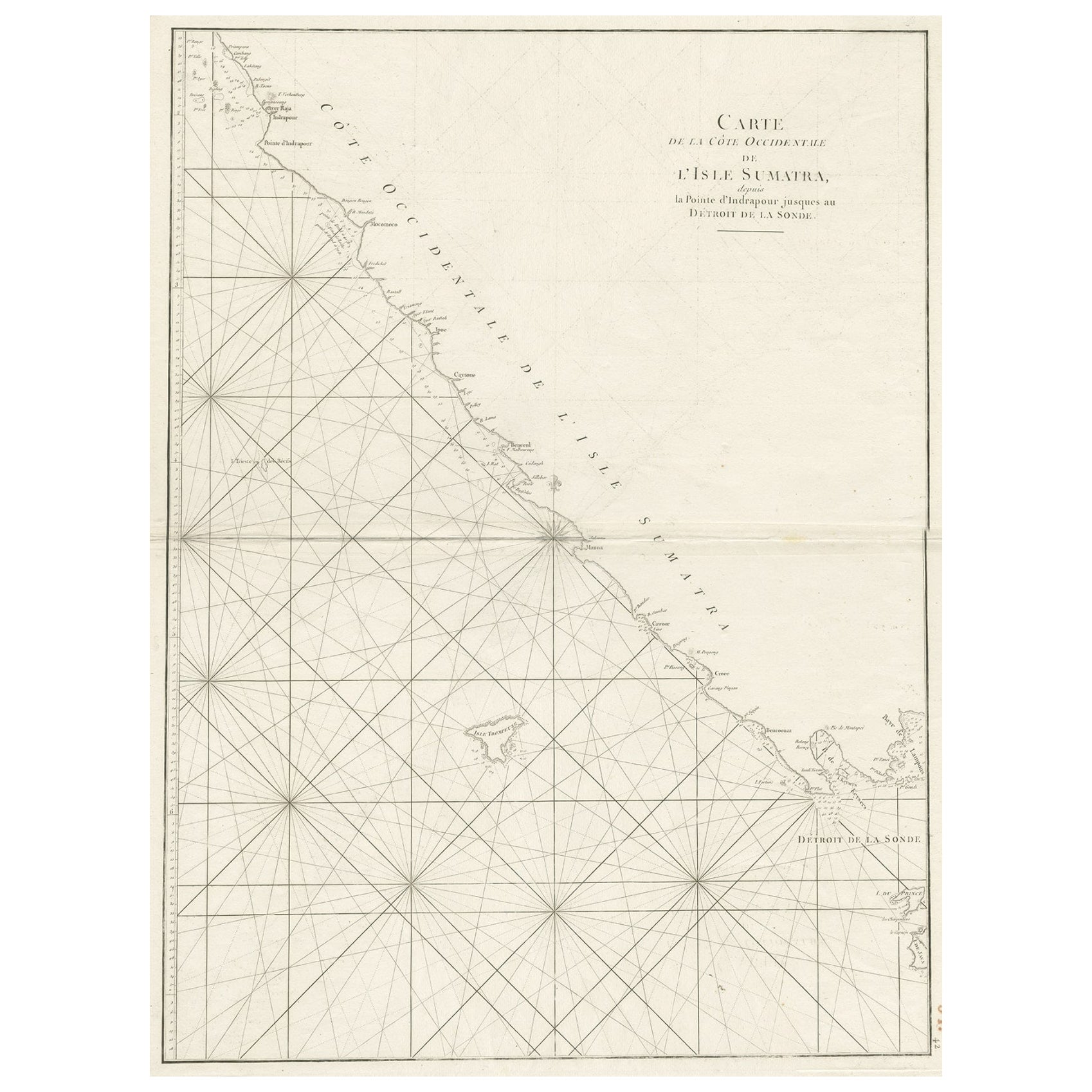
- Sea Chart of Part of the Southwestern Coast of Sumatra & Nias, Indonesia, C1775Located in Langweer, NLAntique map titled 'Carte de la Côte Occidentale de l'Isle Sumatra'. Sea chart of the part of the south-western coast of Sumatra with the Nassau (Nias) and Fortune isles. Artists ...Category
Antique 1770s Maps
MaterialsPaper
- Antique Map of the East Coast of Sumatra , Indonesia, 1900Located in Langweer, NLAntique map of the East Coast of Sumatra. Also depicting the Strait of Malacca. This map originates from 'Atlas van Nederlandsch Oost- en West-Indië' by I. Dornseiffen. Artists and...Category
20th Century Maps
MaterialsPaper
- Antique Sea Chart of the Coast of Sumatra, Indonesia, circa 1775Located in Langweer, NLAntique map titled 'Carte de la Côte Occidentale de l'Isle Sumatra'. Sea chart of the part of the south-western coast of Sumatra with the Nassau (Nias) and Fortune isles. Artists ...Category
Antique 18th Century Maps
MaterialsPaper
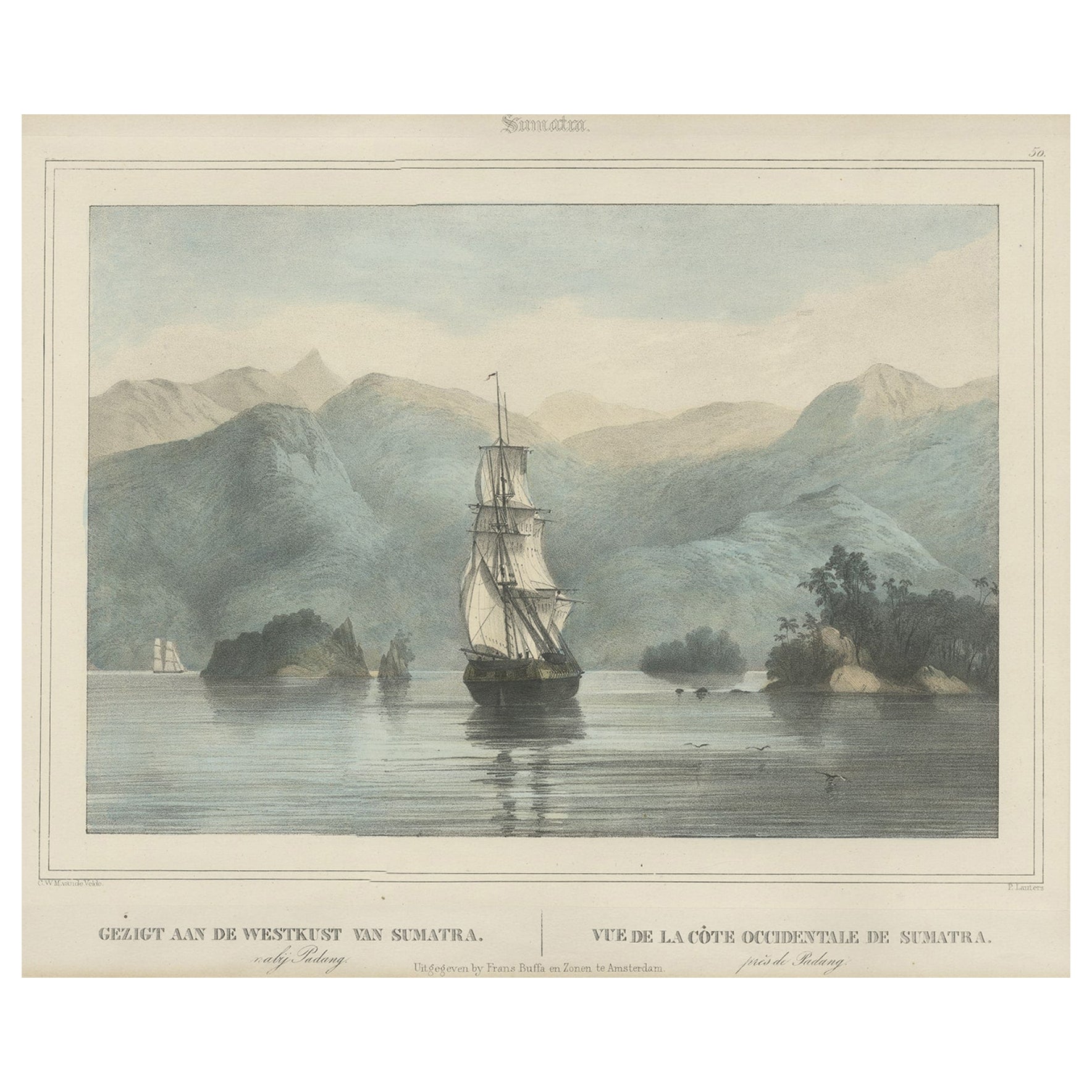
- Antique Print of a Ship Near the Coast of Sumatra, Indonesia, c.1845Located in Langweer, NLAntique print titled 'Gezigt aan de Westkust van Sumatra - Vue de la Côte Occidentale de Sumatra'. Lithograph on chine collé with a view of a ship near the coast of Sumatra, Indonesi...Category
Antique 19th Century Prints
MaterialsPaper
- Large Chart of the island and sea of Java, IndonesiaLocated in Langweer, NLAntique map titled 'Carte Esférica de la Isla Y Mar de Java'. Large chart of the island and sea of Java, Indonesia. Beautiful nautical chart, published 1863 in Spain.Category
Antique Mid-19th Century Maps
MaterialsPaper
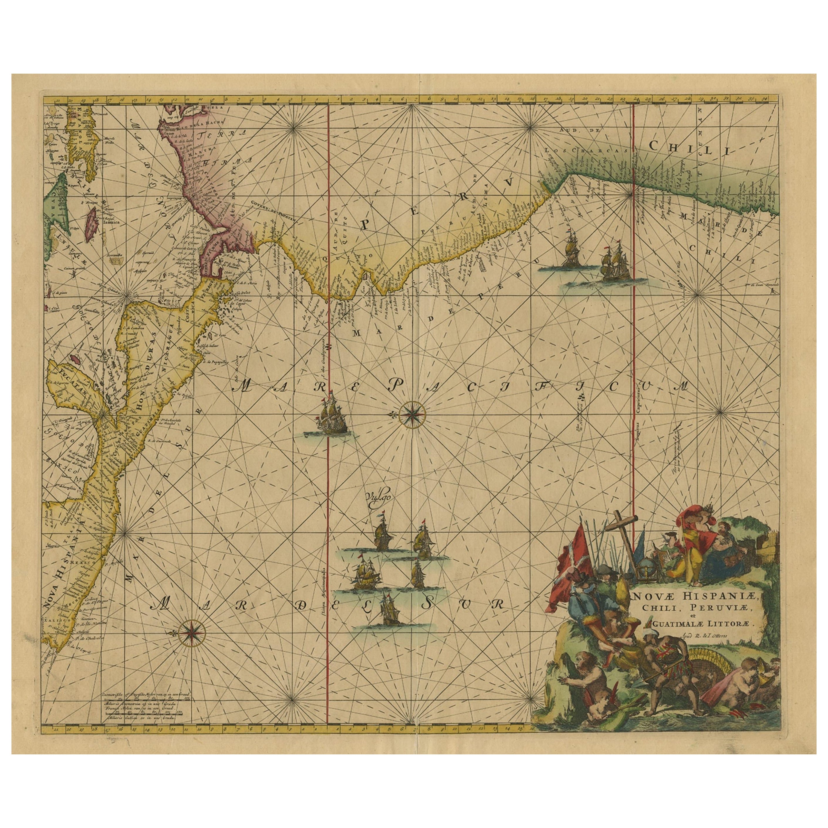
- Sea Chart of Central America and the Northwest Coast of South America, ca.1745Located in Langweer, NLAntique map titled 'Novae Hispaniae, Chili, Peruviae et Guatamala Littorae.' Sea chart of Central America and the northwest coast of South America, oriented to the east, by Reini...Category
Antique 1740s Maps
MaterialsPaper


You May Also Like
- Antique Anatomical Wall Chart Depicting the Human SkeletonLocated in Berghuelen, DEA rare 19th century anatomical wall chart depicting the human skeleton. On the sides On the sides are detailed description in German language. The wall...Category
Early 20th Century German Victorian Prints
MaterialsPaper
- Chart of the East Coast of EnglandLocated in Norwell, MAChart of the East Coast of England, from Dungeness to Flamborough, including the entrances to the Thames River. Drawn by hydrographer J.W. Norie in 1841. Includes Kent, Essex and Suf...Category
Antique 1840s English Nautical Objects
MaterialsPaper
- Chart of West Coast of South America by James Imray and SonLocated in Norwell, MAChart of West Coast of South America compiled by James F. Imray and published in 1880. The chart captures the west coast from Valparaiso to Truxillo. Includes ...Category
Antique 1880s English Nautical Objects
MaterialsPaper
- Original Antique Map of South America, circa 1830Located in St Annes, LancashireGreat map of South America Copper plate engraving Published by Butterworth, Livesey & Co., circa 1830 Unframed.Category
Antique Early 1800s English Other Maps
MaterialsPaper
- Original Antique Map of South Africa, Arrowsmith, 1820Located in St Annes, LancashireGreat map of South Africa. Drawn under the direction of Arrowsmith. Copper-plate engraving. Published by Longman, Hurst, Rees, Orme and Br...Category
Antique 1820s English Maps
MaterialsPaper
- Antique Foldable Anatomical Wall Chart Depicting Human MusculatureLocated in Berghuelen, DEAntique Foldable Anatomical Wall Chart Depicting Human Musculature The rare 19th century anatomical wall chart depicts the human musculature and inter...Category
Early 20th Century German Victorian Prints
MaterialsWood, Paper


Recently Viewed
View AllMore Ways To Browse
Sea Antique
Antique Nearby
French Sailor
Antique Voyage
Voyage Antique
Antique Furniture Nearby
Used Office Furniture Nearby
18th Century Indonesia
18th Century Indonesian
Oriental Antiques Collectables
Antique New Zealand
Sea Isle
Antique Furniture New Zealand
New Zealand Antique Furniture
Northern France Map
Antique Furniture Detroit
Sea Chart
Map Zealand