Items Similar to Chart of West Coast of South America by James Imray and Son


Want more images or videos?
Request additional images or videos from the seller
1 of 11
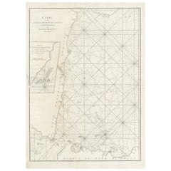
Chart of West Coast of South America by James Imray and Son
About the Item
Chart of West Coast of South America compiled by James F. Imray and published in 1880. The chart captures the west coast from Valparaiso to Truxillo. Includes cities along the coast, including the Guanape Islands. Massive and impressive piece.
Overall Dimensions: Weight is 21 pounds. 80"H x 45"W.
- Dimensions:Height: 80 in (203.2 cm)Width: 43 in (109.22 cm)Depth: 1 in (2.54 cm)
- Materials and Techniques:
- Place of Origin:
- Period:
- Date of Manufacture:1880
- Condition:
- Seller Location:Norwell, MA
- Reference Number:
About the Seller
5.0
Vetted Seller
These experienced sellers undergo a comprehensive evaluation by our team of in-house experts.
Established in 1967
1stDibs seller since 2015
346 sales on 1stDibs
Typical response time: 2 hours
- ShippingRetrieving quote...Ships From: Norwell, MA
- Return PolicyThis item cannot be returned.
More From This SellerView All
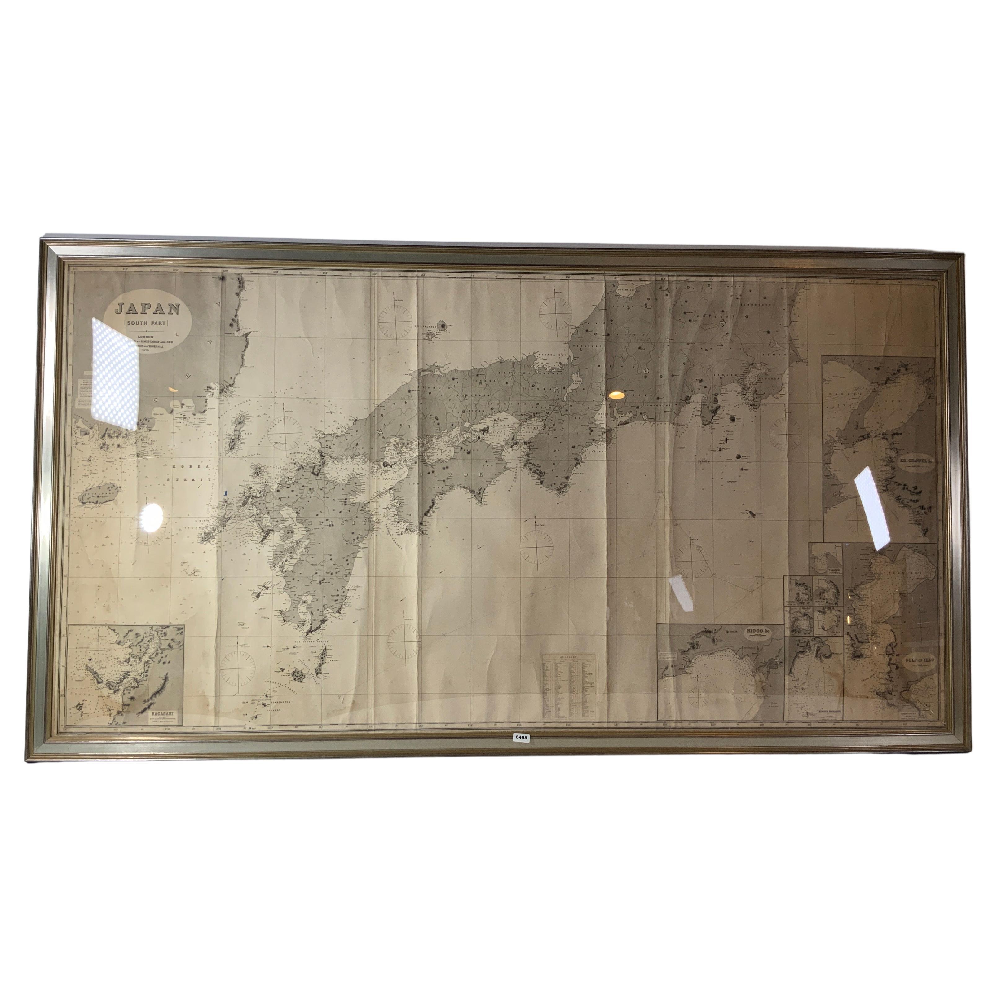
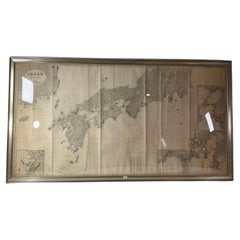
- Chart of Japan by James Imray and SonLocated in Norwell, MAChart of southern Japan compiled by James F. Imray and published in 1870. The chart captures the coast and islands. Includes Nagasaki, Kii Channel, Gulf of Yed...Category
Antique 1870s English Nautical Objects
MaterialsPaper
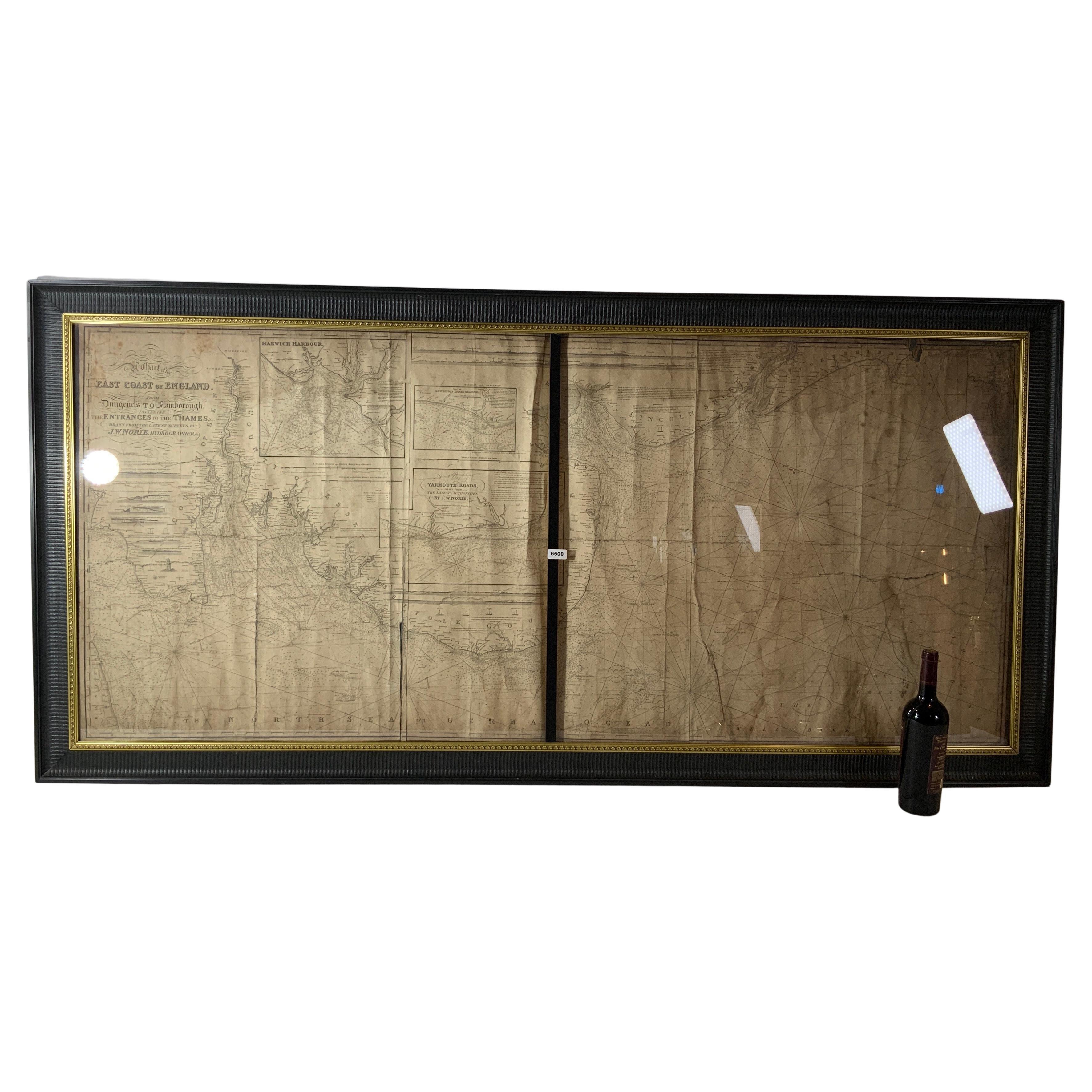
- Chart of the East Coast of EnglandLocated in Norwell, MAChart of the East Coast of England, from Dungeness to Flamborough, including the entrances to the Thames River. Drawn by hydrographer J.W. Norie in 1841. Includes Kent, Essex and Suf...Category
Antique 1840s English Nautical Objects
MaterialsPaper
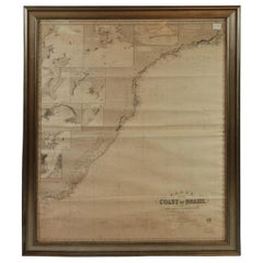
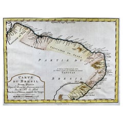
- Imray Ocean Chart of the Coast of Brazil 1876Located in Norwell, MAImray & Son 1876 Nautical chart of the Coast of Brazil between Cape Frio and the River Plate. Nicely framed. Overall Dimensions: 46" H x 56" W.Category
Antique 1870s Nautical Objects
MaterialsPaper
- Original Imray & Son Chart of North Atlantic, 1876Located in Norwell, MANautical chart of the North Atlantic showing the Eastern United States coast, Caribbean Islands, South America (Venezuela and ), British Possessions (Canada - Gulf of Lawrence, Newfo...Category
Antique 1870s Nautical Objects
MaterialsPaper
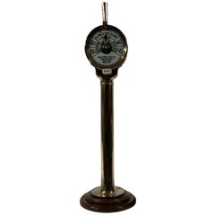
- Ship's Engine Order Telegraph by Charles Cory and Son of New YorkLocated in Norwell, MASolid brass ship's engine order telegraph with faceplates from Charles Cory and Son Patentees, New York. Smaller size than most, meticulously polished and lacquered. Overall Dime...Category
Vintage 1920s American Nautical Objects
MaterialsBrass
- Long Island Chart from 1828Located in Norwell, MARare original chart of Long Island Sound by E + G Blunt of New York, 179 Water St. "Surveyed in the years 1828, 29 & 30" Exceedingly rare and early chart, titled Long Island Sound fr...Category
Antique 1830s Nautical Objects
MaterialsPaper


You May Also Like
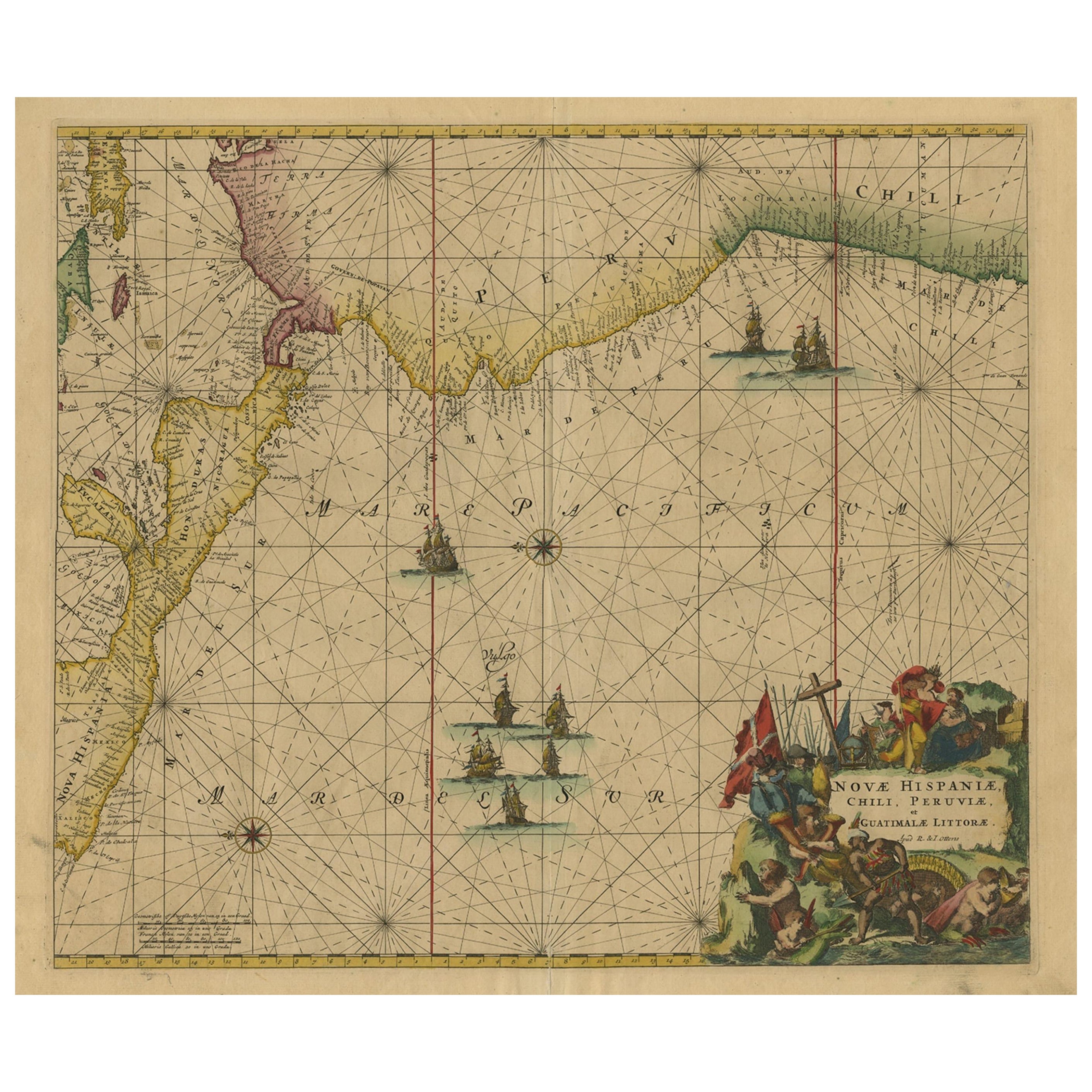
- Sea Chart of Central America and the Northwest Coast of South America, ca.1745Located in Langweer, NLAntique map titled 'Novae Hispaniae, Chili, Peruviae et Guatamala Littorae.' Sea chart of Central America and the northwest coast of South America, oriented to the east, by Reini...Category
Antique 1740s Maps
MaterialsPaper
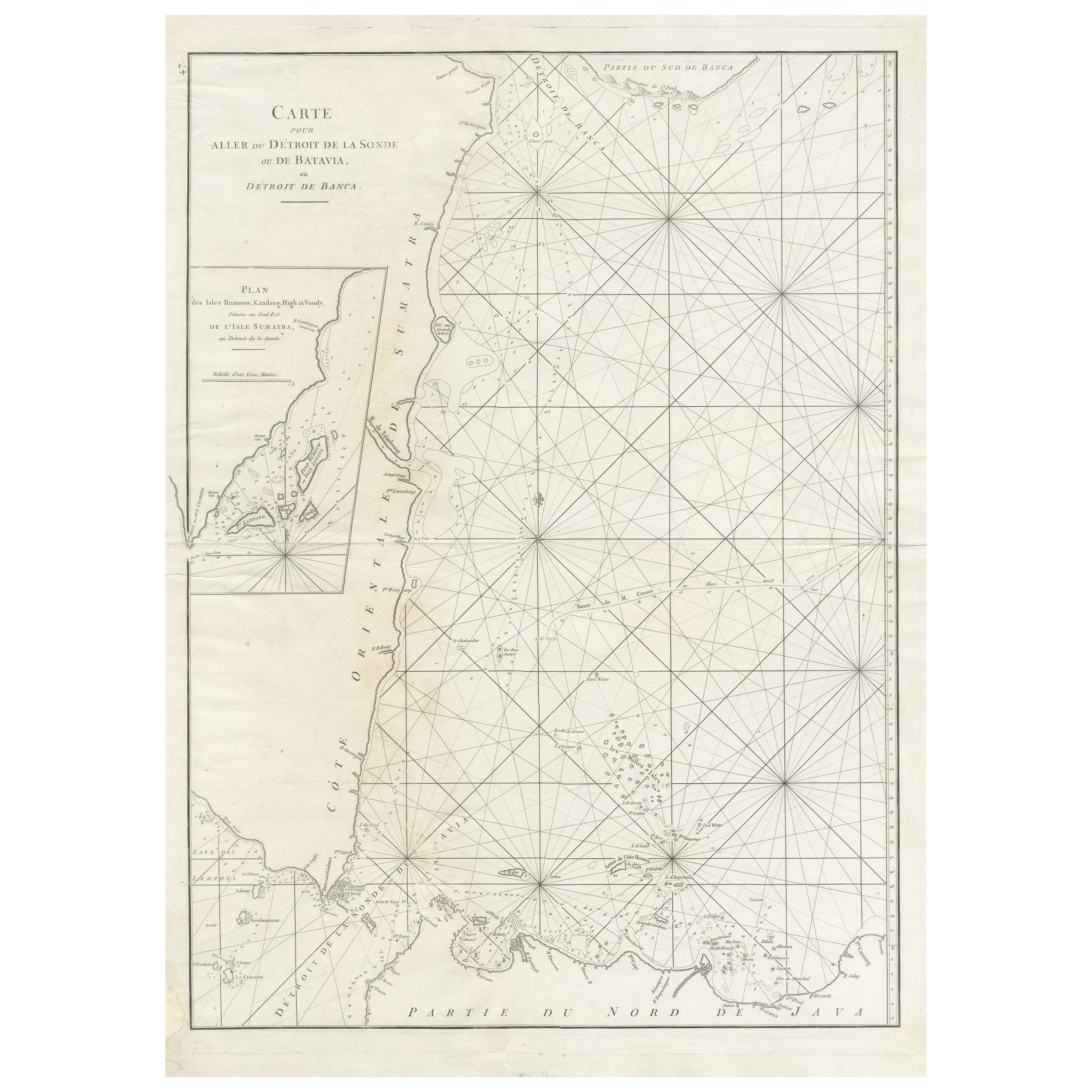
- Large Antique Sea Chart of the South-Eastern Coast of Sumatra, IndonesiaLocated in Langweer, NLAntique map titled 'Carte pour aller du Détroit de la Sonde ou de Batavia, au Détroit de Banca'. This uncommon sea chart shows northern Java and eastern Sumatra along with an inset of the small islands in the Detroit Sound. The handsome chart provides detailed navigational information, including the route of Julien Crozet in April 1772, who led a French expedition to the South Pacific after the voyage's commander, Marion De Fresne, and 26 crew members were killed (and allegedly eaten) by a Maori tribe in the Bay of Islands off the coast of New Zealand. With title upper left corner and small inset map of the small isles nearby the south-eastern coast of Sumatra. J. B. d'Apres de Mannevillette, from his atlas "Neptune orientale". French sailor...Category
Antique Late 18th Century Maps
MaterialsPaper
- Antique Map of the West Coast of North America & North East Coast of Asia '1772'Located in Langweer, NLAntique map titled 'Carte des nouvelles decouvertes/ Extrait d'une Carte Japonoise de l'Universe'. Map of the West Coast of North America and North-East Coast of Asia, based upon Buache's report of the various Russian Discoveries between 1731 and 1742 including the various explorers routes and notes. The lower map is based upon a Japanese map...Category
Antique Late 18th Century Maps
MaterialsPaper
- Antique Print of a Woman of the West Coast of North America by Cook, 1803By CookLocated in Langweer, NLAntique print titled 'Vrouw van Prins Willems Kanaal'. Antique print depiciting a native of the west coast of North America. Originates from 'Reizen Rondom de Waereld door James Cook...Category
Antique 19th Century Prints
MaterialsPaper
- 19th Century Chromolithograph of a Sailor BoyLocated in Nantucket, MA19th Century chromolithograph of a sailor boy, circa 1880, a colored print on canvas view of a young American sailor boy sitting astride a bowsprit. A class...Category
Antique Late 19th Century American Victorian Prints
MaterialsCanvas
- Krevelt, Map, Coast of Brazil, South America, Amazon, Hand ColouredLocated in Norwich, GBCarte Du Bresil Prem. Partie Depuis la Riviere des Amazones jusqu' à la Baie de Tous les Saints Pour servir à l'Histoire des Etablissemens Europeens. A. v. Krevelt, sculpsit, ...Category
Antique Late 18th Century French Prints
MaterialsPaper


Recently Viewed
View AllMore Ways To Browse
South America
England 1889
South West Furniture
Paper Weight Antique
Antique Paper Weights
Antique Paper Weight
Nautical Chart Nautical Chart
Used Nautical Charts
Nautical Charts
Antique Nautical Charts
Sailors Valentine Art
Nautical Whale
Retro Signal Flags
Sailor Rope
Sperm Whale
Shell Valentine
Antique Ship Figurehead
Retro Nautical Signal Flags