Items Similar to Antique Sea Chart of the Coast of Sumatra, Indonesia, circa 1775

Want more images or videos?
Request additional images or videos from the seller
1 of 6
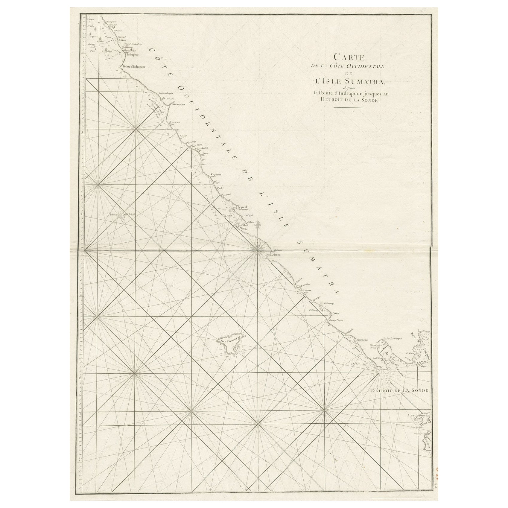
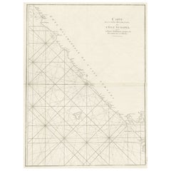
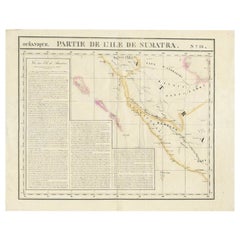
Antique Sea Chart of the Coast of Sumatra, Indonesia, circa 1775
About the Item
Antique map titled 'Carte de la Côte Occidentale de l'Isle Sumatra'. Sea chart of the part of the south-western coast of Sumatra with the Nassau (Nias) and Fortune isles.
Artists and Engravers: D' Après de Mannevillette (1707-1780) was a famous French sailor and hydrograph. During a voyage to China in 1728 he succeeded in correcting the latitudes of many places using new instruments. Back in France he devised a plan to correct and publish all the existing maps of the route to China: the Red Sea, the coasts of India, Malaya, the northern parts of Indonesia, Indochina and China
Condition: Good, general age-related toning. Few stains, blank verso. Please study image carefully.
Date: circa 1775
Overall size: 55 x 78 cm.
Image size: 48.5 x 66 cm.
We sell original antique maps to collectors, historians, educators and interior decorators all over the world. Our collection includes a wide range of authentic antique maps from the 16th to the 20th centuries. Buying and collecting antique maps is a tradition that goes back hundreds of years. Antique maps have proved a richly rewarding investment over the past decade, thanks to a growing appreciation of their unique historical appeal. Today the decorative qualities of antique maps are widely recognized by interior designers who appreciate their beauty and design flexibility. Depending on the individual map, presentation, and context, a rare or antique map can be modern, traditional, abstract, figurative, serious or whimsical. We offer a wide range of authentic antique maps for any budget.
- Dimensions:Height: 30.71 in (78 cm)Width: 21.66 in (55 cm)Depth: 0 in (0.01 mm)
- Materials and Techniques:
- Period:
- Date of Manufacture:circa 1775
- Condition:Condition: Good, general age-related toning. Few stains, blank verso. Please study image carefully.
- Seller Location:Langweer, NL
- Reference Number:
About the Seller
5.0
Platinum Seller
These expertly vetted sellers are 1stDibs' most experienced sellers and are rated highest by our customers.
Established in 2009
1stDibs seller since 2017
1,928 sales on 1stDibs
Typical response time: <1 hour
- ShippingRetrieving quote...Ships From: Langweer, Netherlands
- Return PolicyA return for this item may be initiated within 14 days of delivery.
More From This SellerView All
- Sea Chart of Part of the Southwestern Coast of Sumatra & Nias, Indonesia, C1775Located in Langweer, NLAntique map titled 'Carte de la Côte Occidentale de l'Isle Sumatra'. Sea chart of the part of the south-western coast of Sumatra with the Nassau (Nias) and Fortune isles. Artists ...Category
Antique 1770s Maps
MaterialsPaper
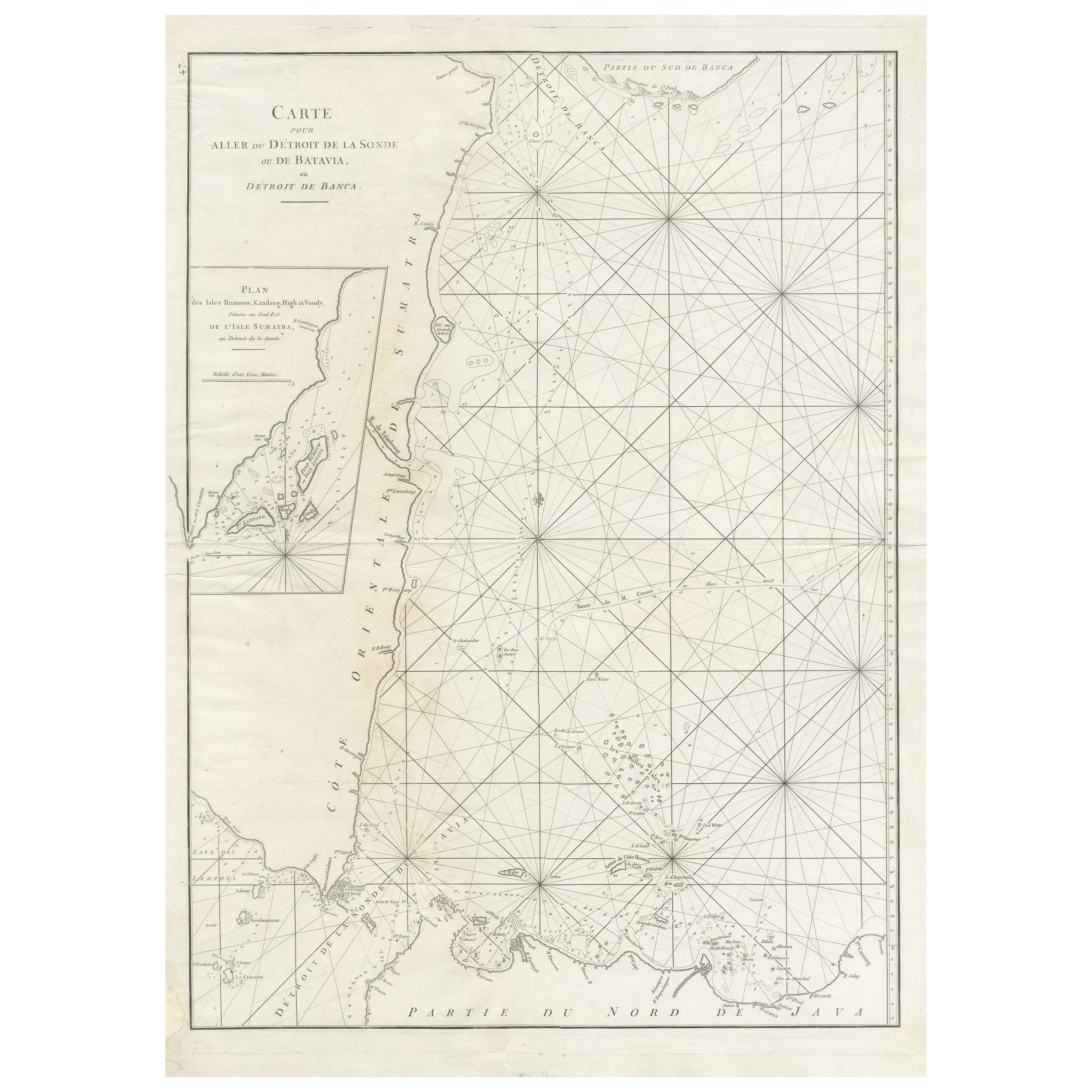
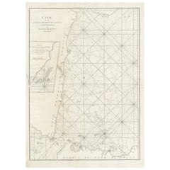
- Large Antique Sea Chart of the South-Eastern Coast of Sumatra, IndonesiaLocated in Langweer, NLAntique map titled 'Carte pour aller du Détroit de la Sonde ou de Batavia, au Détroit de Banca'. This uncommon sea chart shows northern Java and eastern Sumatra along with an inset of the small islands in the Detroit Sound. The handsome chart provides detailed navigational information, including the route of Julien Crozet in April 1772, who led a French expedition to the South Pacific after the voyage's commander, Marion De Fresne, and 26 crew members were killed (and allegedly eaten) by a Maori tribe in the Bay of Islands off the coast of New Zealand. With title upper left corner and small inset map of the small isles nearby the south-eastern coast of Sumatra. J. B. d'Apres de Mannevillette, from his atlas "Neptune orientale". French sailor...Category
Antique Late 18th Century Maps
MaterialsPaper
- Antique Map of the East Coast of Sumatra , Indonesia, 1900Located in Langweer, NLAntique map of the East Coast of Sumatra. Also depicting the Strait of Malacca. This map originates from 'Atlas van Nederlandsch Oost- en West-Indië' by I. Dornseiffen. Artists and...Category
20th Century Maps
MaterialsPaper
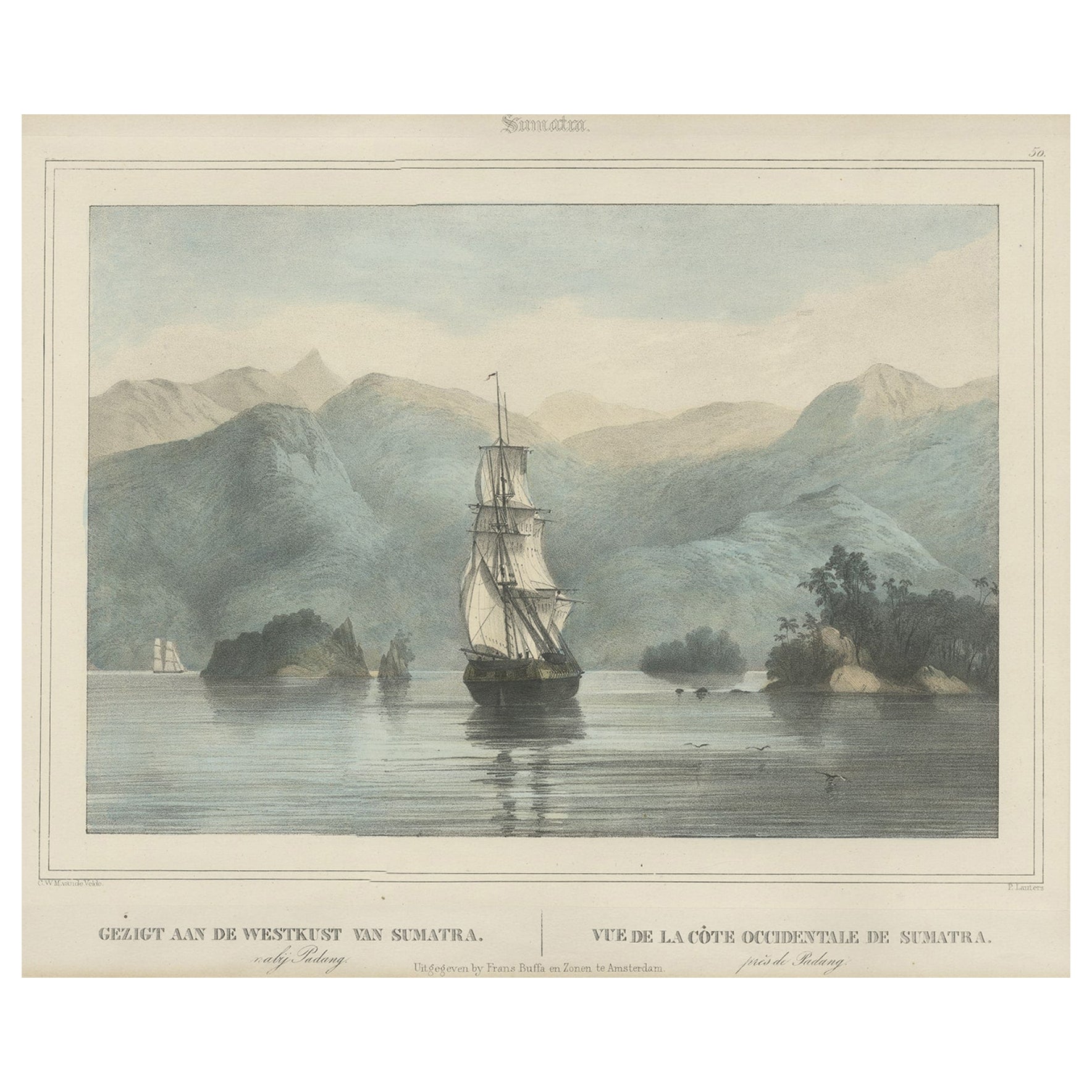
- Antique Print of a Ship Near the Coast of Sumatra, Indonesia, c.1845Located in Langweer, NLAntique print titled 'Gezigt aan de Westkust van Sumatra - Vue de la Côte Occidentale de Sumatra'. Lithograph on chine collé with a view of a ship near the coast of Sumatra, Indonesi...Category
Antique 19th Century Prints
MaterialsPaper
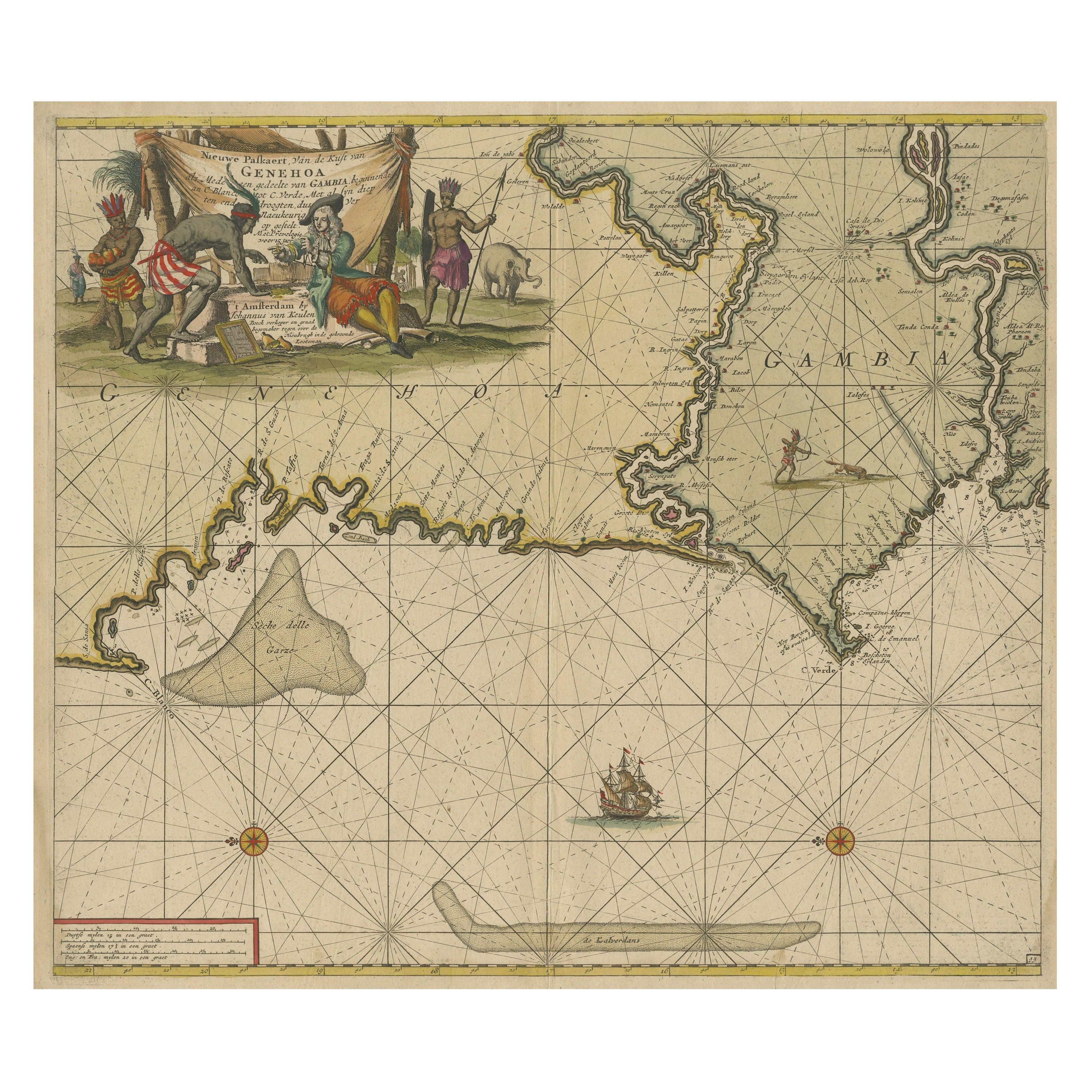
- Antique Sea Chart of the Western Coast of AfricaLocated in Langweer, NLAntique map titled 'Nieuwe Paskaert van de Kust van Genehoa (..)'. This attractive sea chart covers the western coast of Africa from Cape Blanco (Ras Nouadhibou) to Cape Verde (Dakar...Category
Antique Late 17th Century Maps
MaterialsPaper
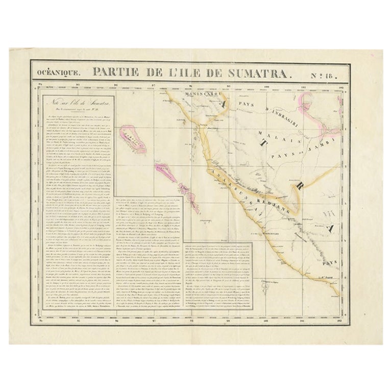
- Detailed Antique Map of the Western Sumatra, Indonesia, circa 1825Located in Langweer, NLAntique map titled 'Partie de l'Ile de Sumatra'. Chart showing the western part of Sumatra. Originates from 'Atlas Universel' by P.M. Vandermaelen. Artists and Engravers: Philipp...Category
Antique 19th Century Maps
MaterialsPaper


You May Also Like
- Imray Ocean Chart of the Coast of Brazil 1876Located in Norwell, MAImray & Son 1876 Nautical chart of the Coast of Brazil between Cape Frio and the River Plate. Nicely framed. Overall Dimensions: 46" H x 56" W.Category
Antique 1870s Nautical Objects
MaterialsPaper
- Red Sea, The Saudi CoastBy Assouline PublishingLocated in NEW YORK, NYBordering the coastlines of eight countries, the Red Sea is a melting pot of civilizations, faiths and hopes. With unique coral reefs and diverse underwater life...Category
2010s American Books
MaterialsLinen
- Set of 5 Large Original Vintage Sea Charts, circa 1920Located in St Annes, Lancashire5 great maps or charts of the oceans I particularly like the color of these maps Unframed Original color By John Bartholomew and Co. Edinburgh Geographical Institute Published, ...Category
Vintage 1920s British Maps
MaterialsPaper
- Edinburgh, Scotland Coast: A 17th Century Hand-Colored Sea Chart by CollinsBy Captain Greenvile CollinsLocated in Alamo, CAThis hand-colored sea chart is entitled "Edinburgh Firth" from "Great Britain's Coasting Pilot. Being a New and Exact Survey of the Sea-Coast of England" by Captain Greenville Collin...Category
Antique Late 17th Century English Maps
MaterialsPaper
- 1775 A Dictionary of the English LanguageBy Samuel JohnsonLocated in Bath, GBAn important edition of Samuel Johnson's dictionary of the English language, being the first complete edition to be printed in Ireland. The first edition thus, being the first quart...Category
Antique 1770s British Books
MaterialsPaper
- Chart of the Harbour of LiverpoolLocated in Cheshire, GBPL Burdett A Chart of the Harbour of Liverpool hand coloured. Encased in an ebonised frame. Dimensions Height 23.5 Inches Width 28 Inches Depth 1 InchesCategory
Early 20th Century British Maps
MaterialsPaper


Recently Viewed
View AllMore Ways To Browse
Leicestershire Antique Map
Alabama Antique Map
Antique Alabama Map
Berkshire Antique Map
Ontario Map
Warwickshire Antique Map
Antique Map Of Alabama
Heinrich Kiepert On Sale
Hertfordshire Antique Map
Poired Metal
Ruscelli Map
Antique Map Kentucky
Antique Map Tennessee
Antique Maps Of Tennessee
Huntingdonshire Antique Map
Mappemonde Antique
Tennessee Map
Antique Bermuda Maps